A confined area is an area where the flight of the helicopter is limited in some direction by terrain or the presence of obstructions, natural or manmade. For example, a clearing in the woods, a city street, a road, a building roof, and so on, can each be regarded as a confined area.
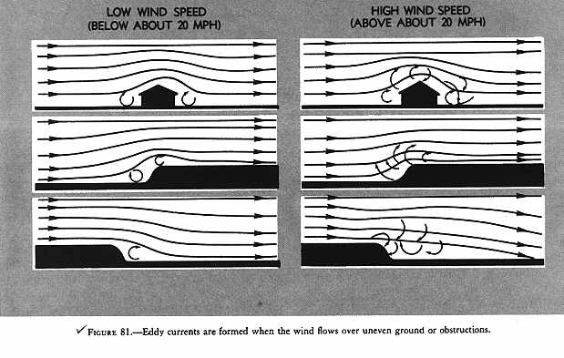
Barriers on the surface and the surface itself may interfere with the smooth flow of air, resulting in turbulence. This interference is transmitted to upper air levels as larger but less intense disturbances. Therefore, the greatest turbulence is usually found at low altitudes. Gusts are unpredictable variations in wind velocity. Ordinary gusts are dangerous only in slow flight at very low altitudes. The pilot may be unaware of the gust, and its cessation may reduce airspeed below that required to sustain flight due to the loss in effective translational lift. Gusts cannot be planned for or anticipated. Turbulence, however, can generally be predicted. Turbulence will be found in the following areas when wind velocity exceeds 10 MPH (fig. 81):
1 - Near the ground of the downwind side of trees, buildings, hills, or other obstructions. The turbulent area is always relative in size to that of the obstacle, and relative in intensity to the velocity of the wind.
2 - Near the surface on the immediate upwind side of any solid barrier such as trees in leaf, and buildings. This condition is not generally dangerous unless the wind velocity is approximately 20 MPH or higher.
3 - In the, air, above and slightly downwind of any sizable obstruction, such as a hill or mountain range. The size of the obstruction and the wind velocity govern the severity and the height to which the turbulence extends.
GENERAL RULES FOR CONFINED AREA OPERATIONS
Some general rules can be stated that apply to helicopter operations in any type of confined area. The following are some of the more important ones to consider regardless of whether such areas are enclosed, or are slopes or pinnacles.
1. Know the direction and approximate speed of the wind at all times, and plan landings and takeoffs with these wind conditions in mind. This does not necessarily mean that takeoffs and landings will always be made into the wind, but wind must be considered, and many times its velocity will determine proper avenues of approach and takeoff.
2. If possible, plan a flightpath over areas suitable for forced landings in case of engine failure. It may be necessary to choose between an approach which is crosswind but over an open area and one directly into the wind but over heavily wooded or extremely rough terrain where a safe forced landing would be impossible. Perhaps the initial phase of the approach can be made crosswind over the open area and then a turn made into the wind for the final portion of the approach.
3. Always operate the helicopter as closely to its normal capabilities as possible considering the situation at hand. In all confined area operations, with the exception of the pinnacle operation, the angle of descent should be no steeper than necessary to clear any barrier in the avenue of approach and still land on the selected spot. The angle of climb, on takeoff, should be normal, or not steeper than necessary to clear any barrier. Clearing a barrier by a few feet and maintaining normal operating RPM, with perhaps a reserve of power, is better than clearing a barrier by a wide margin but with a dangerously low RPM and no power reserve.
4. Always make the landing to a specific point and not to some general area. This point should be located well forward - away from the approach end of the area. The more confined the area, the more essential it is that the helicopter be landed precisely at a definite point. This point must be kept in sight during the entire final approach.
Figure 81 - Eddy currents are formed when the wind flows over uneven ground or obstructions.
5. Any large increase in elevation between the point of takeoff and the point of intended landing must be given due consideration, as sufficient power must be available to bring the helicopter to a hover at the point of the intended landing. A decrease in wind should also be allowed for because of the presence of obstructions.
6. When flying a helicopter near obstructions, always consider the tail rotor. A safe angle of descent over barriers must be established to ensure tail rotor clearance of all obstructions. After coming to a hover, care must be taken to avoid turning the tail into obstructions.
7. If possible, a normal takeoff from a hover should be made when departing a confined area. However, if barriers of sufficient height exist that would make this impossible, then a maximum performance takeoff should be made.
PINNACLE AND RIDGELINE OPERATIONS
A pinnacle is an area from which the surface drops away steeply on all sides. A ridgeline is a long area from which the surface drops away steeply on one or two sides, such as a bluff or precipice. Barriers are not usually present on pinnacles or ridgelines; but, if they are, a combination of pinnacle and confined area operations may be necessary when operating into and out of such areas. That is, an area may require a pinnacle-type operation during the approach and landing, but if the strength of the wind dictates the takeoff path and barriers exist under that path, a confined area-type takeoff may be required when departing that area. Conversely, conditions and terrain may justify a confined area-type approach into an area and a pinnacle-type departure from that area.
The absence of barriers does not necessarily lessen the difficulty of pinnacle or ridgeline operations. Updrafts, downdrafts, and turbulence, together with unsuitable terrain in which to make a forced landing, may still present extreme hazards.
General rules for pinnacle and ridgeline operations
The following are some of the more important rules to consider when conducting pinnacle or ridgeline operations:
1. If necessary to climb to a pinnacle or ridgeline, the climb should be performed on the upwind side, when practicable, to take advantage of any updrafts.
2. Load, altitude, wind conditions, and terrain features determine the angle to use in the final part of an approach. A steeper-than-normal approach may be used when barriers or excessive downdrafts exist. A shallower-than-normal approach may be used when there are no barriers or downdrafts and when it is suspected that the helicopter cannot be hovered out of ground effect. In this case, an approach to the surface may be necessary.
3. The approach path to a ridgeline is usually parallel to that ridgeline and as nearly into the wind as possible. If a crosswind exists, remain clear of downdrafts on the leeward or downwind side of the ridgeline. If the wind velocity makes the crosswind landing hazardous, a low coordinated turn into the wind may be made just prior to terminating the approach.
4. When making an approach to a pinnacle, avoid leeward turbulence and keep the helicopter within reach of a forced landing area as long as possible.
5. Since pinnacles and ridgelines are generally higher than the immediate surrounding terrain, gaining airspeed on the takeoff is more important than gaining altitude. The airspeed gained will cause a more rapid departure from the area. In addition to covering unfavorable terrain rapidly, a higher airspeed affords a more favorable glide angle and thus contributes to the chances of reaching a safe area in the event of a forced landing. If no suitable area is available, a higher airspeed will permit a more effective flare prior to making an autorotative landing.
HIGH RECONNAISSANCE
The primary purpose of the high reconnaissance is to determine the suitability of an area for a landing. In a high reconnaissance, the following items should be accomplished:
1 - Determine wind direction and speed.
2 - Select the most suitable flightpaths into and out of the area, with particular consideration being given forced landing areas.
3 - Plan the approach and select a point for touchdown.
4 - Locate and determine the size of barriers, if any, immediately around the area. A high reconnaissance is flown at approximately 500 feet above the surface; however, a higher altitude may be required in some helicopters. A general rule to follow is to ensure that sufficient altitude is available at all times to land into the wind in case of engine failure. This means the greatest altitude will be required when headed downwind. A 45° angle of observation will generally allow the best estimate of the height of barriers, the presence of obstacles, the size of the area, and the slope of the terrain. Safe altitudes and airspeeds should be maintained and a forced landing area should be kept within reach whenever possible.
The approach path should be generally into the wind and over terrain that minimizes the time that the helicopter is not in reach of a forced landing area. If by flying at an angle to the wind, a forced landing area can be kept in reach, then do so. Having a forced landing area available is more important than to fly directly into the wind, especially if the wind is not too strong. The decision should be made as to the type of approach that will be made. If at all possible, a normal approach should be made; however, if there are high barriers, a steeper approach will be required.
LOW RECONNAISSANCE
In the low reconnaissance, verify what was seen in the high reconnaissance and check for anything new that may have been missed. Check especially for wires, slopes, and small crevices because these are especially difficult to see from a higher altitude.
A low reconnaissance begins shortly after entry to the approach and ends at touchdown. During this time, objects on the surface can be better identified and the height of barriers, if any, better estimated. The view of the approach path is greatly improved. The approach should be as close to a normal approach as possible. If new information warrants a change in flightpath or angle of descent, it should be made; however, if a major change in angle of descent is required, a go-around should be made. If a decision to go around is made, it should be done prior to losing effective translational lift.
If a decision is made to complete the approach, the termination should normally be to a hover so the landing point can be carefully checked before the landing is made. Under certain conditions, however, it may be desirable to terminate the approach to the surface. Whether terminating at a hover or on the surface, once the helicopter is on the surface, operating RPM should be maintained until the stability of the helicopter is checked to be sure of a secure and safe position.
GROUND RECONNAISSANCE
Before takeoff, a ground reconnaissance is made to determine the type takeoff to be performed, to determine the point from which the takeoff should be initiated to ensure the maximum amount of available area and, finally, how to best get the helicopter from the landing point to the proposed takeoff position.
The first thing to check is the wind. If the engine is running, walk a sufficient distance from the helicopter to ensure that the downwash of the blades does not interfere. Dust or grass may be dropped and the direction observed in which they are blown.
The next step is to go to the downwind end of the available area and mark a position for takeoff so that the tail and main rotors will have sufficient clearance from the obstructions, if any, behind the helicopter. A sturdy marker such as a heavy stone or log should be used so it will not blow away.
If wind conditions and available area permit, the helicopter should
be brought to a hover, turned around, and hovered forward from the landing
position to the takeoff position. Under certain conditions, sideward flight
to the takeoff position may be necessary. If rearward flight is required
to reach the takeoff position, reference markers should be placed in front
of the helicopter in such a way that a ground track can be safely followed
to the takeoff position and so the pilot can see the marker for the takeoff
position without going beyond it.