1. INTRODUCTION.
This Chapter provides guidance to the general aviation pilot who is flying a light, general aviation aircraft in oceanic operations, and specifically addresses aircraft with a relatively short range that cannot transverse an ocean without intermediate fuel stops.
Many of the chapters in this advisory circular (AC) contain important information relative to oceanic operations. All pilots should scan each of these chapters and determine the pertinence of each chapter relative to the flight being planned. In addition, the information contained in this Chapter should be read in detail. It is important to note that this Chapter includes International Civil Aviation Organization (ICAO) rules and Canadian departure requirements for transoceanic flights. These requirements become regulatory to U.S. pilots by virtue of the content of FAR 91.703. Most short range aircraft crossing the North Atlantic (NAT) will, out of necessity, make a Canadian departure. These aircraft are bound by Canadian regulations in addition to U.S. regulations and ICAO rules. Although emphasis in this Chapter is on NAT flights by short range aircraft, the majority of the information is pertinent to all oceanic operations by short range aircraft with the exception of operations in minimum navigation performance specifications (MNPS) airspace. MNPS operations are covered in detail in Chapter 3.
2. ICAO GUIDANCE.
A number of incidents have occurred with NAT international general aviation (IGA) flights that were caused by noncompliance with basic requirements for navigation and communication equipment needed for oceanic flights or flights over remote areas. Most of the incidents were potentially hazardous to the aircraft occupants and to aircrew members called upon to conduct the searches. Some of the incidents resulted in needless and expensive alert activities on the part of the air traffic control (ATC) communicators and controllers, and in search activities by rescue facilities. The incidents generally involved flights that were considerably off-course or had not made the required position reports. This Section provides information for flight planning and operation of IGA flights across the NAT, in particular those operations carried out by light aircraft. IGA pilots planning to cross the Atlantic at altitudes between flight level (FL) 275 and FL 400 (the altitude limits of MNPS airspace) must obtain a Letter of Authorization (LOA) for FAR Part 91 operations, or must receive operations specifications approval if conducting an air carrier operation. The approval processes are discussed in Chapter 3, Section 4 of this AC. Pilots planning to cross the Atlantic above MNPS airspace (FL 410 or higher) may wish to take advantage of the special climb-out provision detailed in Chapter 3, Section 2 of this AC.
a. The NAT Environment. The climate affecting NAT flight operations
is demanding throughout the year, with storms or other adverse weather
likely to be encountered during any season. It is probable that any transatlantic
flight will encounter adverse weather on at least a portion of the flight.
The scarcity of alternate airports available to transatlantic flights requires
that all significant weather systems along the route be considered during
the flight planning phase. Flights at higher NAT FLs (FL 275 - FL 400)
are required to be equipped and authorized by the FAA for flights in the
NAT MNPS airspace. Radio navigation systems available to pilots include
Omega/very low frequency (VLF), Loran C, and global positioning system
(GPS). However, Loran C coverage is incomplete in many areas, Omega equipped
aircraft using E-field antennae are likely to suffer prolonged loss of
signal reception when in or near a cloud covering, and a GPS system or
sensor that meets the requirements specified in TSO C-129 may be approved
as a means, but not the sole means, of oceanic navigation in NAT MNPS airspace.
Therefore, it is extremely important that pilots understand the capabilities
of their equipment and ensure that accurate navigation facilities exist
to support their equipment throughout all of their proposed flight route.
Several high power non-directional radio beacons (NDB) located in the NAT
region are useful to automatic direction finder (ADF) equipped aircraft.
Some of these stations, including commercial band transmitters, are not
monitored for outages or interference by transmitters on adjacent frequencies
and may be severely affected by atmospheric conditions without warning.
Very high frequency (VHF) communications coverage extends to line-of-sight distance from facilities in Canada, Iceland, Greenland, the Azores and coastal Europe. The Canadian VHF coverage is extended by use of a remote facility in southern Greenland. High frequency (HF) communications are available throughout the NAT region for ATC purposes. Use of HF by pilots on IGA flights permits proper monitoring of the flight's progress. HF equipped flights should be able to receive HF meteorological information for aircraft in flight (VOLMET) broadcasts, including significant meteorological information (SIGMET) and continuous meteorological updates, at major terminals in Europe and North America. Search and rescue (SAR) vessels and aircraft are stationed at some locations in the NAT region, but SAR aircraft may not always be available. The availability of SAR vessels may depend on the disposition of a nation's civil emergency fleet. These fleets are often composed of a nation's fishing fleet, and their proximity may depend on the current fishing situation.
b. Pilot Qualification Requirements. The minimum pilot qualification for any flight across the NAT is a private pilot certificate. Unless operating below FL 60 (6000 feet mean sea level (MSL), the pilot in command (PIC) must hold an instrument rating. The demanding NAT operational environment requires that the PIC have the following flight experience in addition to cross-country flight time:
(1) The PIC must meet the recency of experience requirements stipulated in FAR Part 91.
(2) The PIC must have adequate recent flight experience in the use of the long range navigation and communication equipment to be used. It is highly recommended that pilots document training received and their experience using this equipment prior to embarking on any oceanic flights. This documentation will be invaluable should a navigation error report be filed due to equipment difficulties that cause an error.
c. National Regulations. Pilots of U.S. registered aircraft must comply with all applicable U.S. regulations, ICAO Annex 2, and the regulations of the states in which they land or overfly. In cases when U.S. regulations are more stringent than ICAO rule or vice versa, pilots are bound to adhere to the more stringent regulation or rule.
d. Flight Rules Over the High Seas. ICAO member states have agreed that ICAO flight rules will be in effect for operations over the high seas. However, responsibility for enforcement of these rules rests with the state of registry of the aircraft or the state of registry of the operator. ICAO flight rules are contained in ICAO Annex 2. Procedural aspects are covered in ICAO Document 7030/3-NAT, "Supplementary Procedures Applicable in the NAT Region." Under FAR 91.703, U.S. registered aircraft must comply with ICAO Annex 2. U.S. registered aircraft planning to operate in MNPS airspace must also comply with FAR 91.705. Some of the more significant ICAO rules are paraphrased below:
(1) All flights that cross an international border must file a flight plan.
(2) All flights must file an instrument flight rules (IFR) flight plan when intending to fly in NAT airspace at FL 60 and above in New York, Gander, Shanwick, Santa Maria and Reykjavik Oceanic flight information regions (FIR); at FL 60 and above in the Bodo Oceanic FIR beyond 100 nautical miles (NM) seaward from the shoreline; and at FL 200 and above in the Sondrestrom. FIR.
(3) While enroute, all changes to IFR flight plans shall be reported as soon as practicable to the appropriate air traffic service (ATS) as prescribed.
(4) An arrival report must be sent to the appropriate ATS unit. When
the flight plan cannot be closed by means of the aircraft radio, either
a telephone or telegraphic message should be sent. Failure to close flight
plans may result in a needless search operation.
e. Operation of Aircraft. ICAO member states have agreed that aircraft with their registration mark will comply with the standards concerning the operation of aircraft contained in ICAO Annex 6, as a minimum. Some of the more pertinent standards are paraphrased below:
(1) Before commencing the flight, the pilot must be satisfied that the aircraft is airworthy, duly registered, and that appropriate certificates are on board. Pilots flying U.S. registered aircraft should be especially concerned with the "duly registered" aspects of this section. FAR 47.3 through 47.11 are specific regulations relative to the legality of U.S. registered aircraft
(2) Aircraft instruments and equipment must be appropriate for the operation, considering expected flight conditions. Chapter 2, Section 5 of this AC provides details of required instruments and equipment in addition to the information provided below.
(3) Meteorological information relevant to the flight must be obtained by the PIC and evaluated with regard to the planned route, destination, and alternative courses of action.
(4) Maps and charts that are current, suitable for the flight, and include alternative routes must be available on the aircraft.
(5) SAR information, including location of facilities and procedures to be used, should be obtained by the PIC.
(6) Notices to Airmen (NOTAM) should be checked by the PIC prior to departure to ascertain the status of radio navigational aids (navaids) and airport restrictions.
(7) Night operations can present additional problems that the PIC must consider, such as increased navigation difficulties, fatigue, more demanding pilot skills, and other factors.
(8) The PIC should check the Aeronautical Information Publication (AIP) of states where landings will be made or for states that will be overflown prior to departure. Various chapters in this AC provide the necessary operational information derived from the AIPs, particularly with respect to the requirements for the carriage of survival equipment.
f. Equipment Requirements. Life rafts will be carried when single-engine aircraft operate more than 100 NM from shore, and when multiengine aircraft operate more than 200 NM from shore. These life rafts will contain at least the following:
(1) Pyrotechnic distress signals
(2) Food and water
(3) A VHF survival radio
g. Navigation Equipment. On transatlantic flights, aircraft shall be equipped with navigation equipment that will enable it to proceed in the following capacities:
(1) In accordance with the flight plan
(2) In accordance with the requirements of the ATSs
(3) In accordance with MNPS requirements when operating in that airspace
(also see Chapter 3 for additional information relative to navigation equipment
requirements in MNPS airspace)
h. Communication Equipment. In controlled airspace, flights must be able to conduct two-way radio communication on required frequencies. Use of emergency frequencies as a planned operation is in conflict with this rule. The VHF emergency frequency 121.5 megahertz (MHz) is not authorized for routine use. The frequency 131.800 MHz has been designated for use as the air-to-air communication channel in the NAT region. In the Gander, Shanwick, Santa Maria, Reykjavik, Sondrestrom and New York FIRs, HF radios are required to contact ATS units when beyond the range of VHF. Subject to prior arrangement, VHF-only flights may be made via Canada/Greenland/Iceland/Europe, provided the Shanwick FIR is avoided. It is recommended that pilots planning these types of flights obtain and study the individual AIPs pertaining to their route of flight.
{c11p3}
i. Special Requirements for Flights Transiting Greenland. The elevation of the highest point in Greenland is 13,120 feet MSL, and the general elevation of the icecap is 9,000 feet MSL. Due to the low temperatures and high wind speeds, the lowest useable FL under certain conditions may be FL 235 near the highest point, and FL 190 near the icecap. High-capacity cabin heating systems are needed due to the very low inflight temperatures usually encountered, even in summer. Rapidly changing weather situations involving severe icing, severe turbulence, and heavy precipitation are common and require extra vigilance by pilots. The changes may be so rapid that they are difficult to forecast. An emergency locator transmitter (ELT) is required to transit Greenland due to the very difficult terrain that hampers searches. Regulatory compliance is monitored and states will be informed of any infractions.
Airport flight information is provided at Narssarssuaq Airport, Nuuk/Godthab Airport, Kulusuk Airport and Ilulissat/Jakobshavn Airport at Constable Point. The general locations of these airports are as follows:
* Narssarssuaq is on the southern tip of Greenland at the end of a fjord
* Nuuk/Godthab is on the west coast of Greenland halfway between Narssarssuaq
and Sondrestrom
* Kulusuk is on the east coast of Greenland 343 NM northeast of Narssarssuaq
* Ilulissat/Jakobshavn is on the west coast of Greenland 137 NM north
of Sondrestrom
Only flight information service and alerting service are provided within the Sondrestrom FIR below FL 195. IFR flights operating within the Sondrestrom FIR below FL 195 must have functional radio equipment capable of operating on the published HF's for Sondrestrom. Flights operating within the Sondrestrom FIR below FL 195 must have functional radio equipment capable of operating on the published HF's for Sondrestrom. Flights operating within the Sondrestrom FIR above FL 195 (that is, Reykjavik or Gander control areas (CTA)), and outside of VHF coverage of Iceland or Gander, must have functional radio equipment capable of operating on the published HF's for Iceland/Gander.
j. Special Requirements for Flights Transiting Iceland. The general
elevation of mountainous areas in Iceland is approximately 8000 feet MSL.
Due to the great difference in pressure and high wind speeds, the lowest
useable FL may, under certain conditions, be FL 120. An ELT with an energy
supply independent of the aircraft shall be carried. The ELT must be capable
of functioning continuously outside the aircraft for at least 48 hours,
and of transmitting simultaneously on the frequencies 121.5 and 243 MHz.
Aircraft should be equipped with sufficient and appropriate arctic survival
equipment. Aircraft operating in the oceanic sector of the Reykjavik FIR
must maintain a continuous watch on the appropriate frequency of Iceland
Radio. When operations take place outside of VHF coverage of the air-ground
station, carriage of an HF transceiver operational on appropriate frequencies
is mandatory. However, prior approval may be obtained for flight outside
VHF coverage and without HF equipment. Flights operating under this special
approval are responsible for obtaining similar approval for operating in
the airspace of adjacent ATC units. Flights between FL 80 and FL 195 on
the route between Sondrestrom and Keflavik passing through 65 N 30 W and
Kulusuk, and flights above FL 240 operating between the United Kingdom
and Iceland that are routed at or north of 61 N 10 W, are considered adequately
covered by VHF and are exempted from HF requirements. Navigation equipment
adequate to navigate in accordance with the flight plan and in accordance
with ATC clearances will be carried aboard the aircraft. Secondary surveillance
radar (SSR) transponders with Mode 3/A and C are required in Iceland. Pilots
shall operate SSR transponders continuously on Mode A, Code 2000, except
that departing aircraft shall retain the last assigned code for 30 minutes
after entry into NAT oceanic airspace unless otherwise instructed by ATC.
AIPs and NOTAM information are available on request at all Iceland airports
of entry and from the following:
|
k. Special Requirements for Canadian Departures. Canadian Air Regulation S.540 prohibits single engine aircraft from transoceanic flight departing Canada unless authorization is obtained from the Minister. This regulation also applies to multiengine aircraft that cannot maintain flight after failure of the critical engine. Authorization to commence a transatlantic flight from Canada must be obtained by the PIC of a single engine or multiengine aircraft as described above after landing at Moncton, New Brunswick, Canada. When the Regional Director, Aviation Regulation (or a representative) is satisfied that requirements are met, the authorization will be granted. At least 48 hours prior to landing at Moncton, the pilot should inform the Regional Director, Aviation Regulation, 95 Foundry Street, Moncton, New Brunswick, Canada, E1C 8K6, Telex 0142 666, of the intended transatlantic flight, stating date and time of arrival at Moncton, aircraft type, registration mark, and pilots' and passengers' names and addresses. Inspections are also possible at other regional offices in Montreal, Toronto, Winnipeg, Edmonton, and Vancouver. However, it is requested that the first contact be made with Moncton to coordinate the details of an alternate inspection site.
(1) At Moncton or the alternate inspection site, the PIC shall satisfy an examining officer of the following:
(a) Certification as a pilot with a valid and current instrument rating
(b) Knowledge of the meteorological, communication, ATC, and SAR facilities and procedures on the route to be flown
(c) Knowledge of radio and other navaids, and ability to use these aids enroute
(2) Authorized routes will be those that will provide a minimum of 3 hours fuel reserve at destination considering useable fuel, an appropriate flight manual fuel consumption and true airspeed (TAS) indication (documented or charted), and a ZERO wind component. The PIC must present a complete navigation log for the ocean crossing. The log must show 5 degree longitude checkpoints, tracks, variation, and distances with the capability to recalculate on the basis of the most recent forecast enroute winds. In anticipation of equipment problems, pilots should make preparations to complete the flight using dead reckoning (DR) navigation techniques.
NOTE: Some experienced ferry pilots apply the forecast wind to each 5 degree longitude segment of track to the nearest 10 degrees, then add 10 knots if a headwind, or subtract 10 knots if a tailwind. Next they ensure that both wind direction and track are in magnetic units by applying variation to the true course. If the crosstrack wind component is over 20 knots, or the drift angle is over 10 degrees, they wait for a better wind before departing. High speed, unforecast winds can easily increase the flight time to the extent that a short range aircraft cannot comply with the 3 hour fuel reserve regulation.
(3) Upon arrival at the inspection site, the PIC shall present the following documents for inspection:
(a) Certificate of Registration from the state of registry. U.S. registered aircraft are required to have a permanent registration. Temporary (pink slips) are not satisfactory for oceanic flights.
(b) Certificate of Airworthiness, Flight Permit, or Special Airworthiness Certificate.
(c) Certification and special conditions issued by the state of registry
to allow over gross weight operations, if applicable.
(d) Certification issued by the state of registry for fuel tank modifications and/or the installation of temporary long range tanks. For U.S. registered aircraft, the certification requirements are satisfied by obtaining a completed FAA Form 337, "Major Repair and Alteration."
(e) Revised weight and balance records in the case of aircraft modified to carry extra fuel.
CAUTION: An export Certificate of Airworthiness does not constitute authority to operate an aircraft It must be accompanied by one of the authorities listed in (b) above. These documents are not available at Moncton, and Canadian authorities have no authority to issue these documents to U.S. registered aircraft.
(4) Aircraft are required to carry the following sea survival equipment:
(a) A readily accessible watertight immersion suit for each occupant, including undergarments which provide thermal protection
(b) A readily accessible life jacket, complete with light, for each occupant
(c) A readily accessible Type W, water-activated, self-buoyant, water-resistant ELT
(d) A readily accessible life raft sufficient to accommodate all persons on board the aircraft. The life raft must be fitted with the following items:
(aa) Water, or a means of desalting or distilling saltwater, sufficient to provide at least one pint of water per person
(bb) A water bag
(cc) Water purification tablets
(dd) Food that:
* is in the form of carbohydrates
* has a caloric value of at least 500 calories per person
* is not subject to deterioration by heat or cold
(e) Flares (at least three per life raft)
(f) Hole plugs
(g) A bail bucket and sponge
(h) A signal mirror
(i) A whistle
(j) A knife
(k) A survival-at-sea manual
(l) Waterproof flashlights (minimum two per life raft)
(m) A first aid kit containing eye ointment, bum ointment, compresses, bandages, merthiolate, and seasick pills
(n) A dye marker
(5) The water and food may be stored and carried in appropriate containers separate from the rafts if the containers can be readily and quickly attached to the raft. In addition to the items listed as "sea survival equipment" (above), aircraft shall carry the following polar survival equipment for flights over Labrador, and for any flight routing north of Prins Christian Sund over Greenland:
(a) A signalling sheet (minimum 1 by 1 meters = 3.28 feet by 3.28 feet)
in a reflecting color
(b) A magnetic compass
(c) Winter sleeping bags in sufficient quantity to accommodate all
persons carried
(d) Matches in waterproof covers
(e) A ball of string
(f) A stove and supply of fuel or a self-contained means of providing
heat for cooking and the accompanying messkits,
(g) A snow saw
(h) Candles or some other self-contained means of providing heat with
a burning time of about 2 hours per person. The minimum candles to be carried
shall not be less than 40 hours of burning time
(i) Personal clothing suitable for the climatic conditions along the
route to be overflown
(j) A suitable instruction manual in polar survival techniques
(k) Mosquito netting and insect repellant
(6) Aircraft must be equipped with the following instruments and equipment in serviceable condition:
(a) An airspeed indicator and heated pitot head
(b) A sensitive pressure altimeter
(c) A direct reading magnetic compass that has been swung within the
preceding 30 days with the aircraft in the same configuration as for the
intended transoceanic flight
(d) A gyroscopic direction indicator or a gyromagnetic compass
(e) A turn and bank indicator
(f) A rate of climb and descent indicator
(g) An outside air temperature gauge
(h) A gyroscopic bank and pitch indicator
(i) Unless another timepiece with a sweep-second hand is available,
a reliable, installed timepiece with a sweep-second hand
(j) If there is a probability of encountering icing conditions along
the route to be flown, deicing or anti-icing equipment for the engine,
propeller, and airframe
(k) If any portion of the flight is to be made at night, the following
must be included:
* Navigation lights
* Two landing lights or a single landing light having two separately
energized filaments
* Illumination for all instruments that are essential for the safe
operation of the aircraft
* An electric flashlight at each required flight crewmember's station
NOTE: All equipment and cargo carried in the cabin shall be secured to prevent shifting in flight and placed in such a position so as to not block or restrict the aircraft's exits.
NOTE: Portable oxygen equipment is recommended. This equipment is useful
when trying to avoid icing and/or for the additional altitude required
over the Greenland icecap.
(7) In the oceanic control areas (OCA) and FIRs, VHF coverage is not sufficient to ensure continuous two-way communications with ground stations. Although relay through other aircraft is sometimes possible, it is not guaranteed. As mentioned elsewhere in this AC, emergency frequencies are not to be used for planned position relays or any other purposes except for bona fide emergencies. HF radio is mandatory for each aircraft crossing the Atlantic. The only exception is for aircraft flying at FL 250 or above crossing Greenland. Route specific navigation equipment requirements for navigation in accordance with the flight plan and any ATC clearances are listed below:
(a) Iqualuit [Frobisher Bay] (CFYB) to Greenland: Two independent ADF receivers with BFQ/CW capability. Portable ADFs are no longer acceptable.
(b) Goose Bay, Labrador to Narssarssuaq, Greenland: Two independent ADF receivers with BFO/CW capability.
(c) Goose Bay to Reykjavik, Iceland via Prins Christian Sund, Greenland: Two independent ADF receivers as above, or one ADF set and one Loran C set. Danish CAA strongly recommends two ADF sets because of poor Loran C reception around Greenland.
(d) Gander, Newfoundland to Shannon, Ireland: One Loran C set and one ADF set.
(e) St John's, New Brunswick to Santa Maria (Azores): One Loran C set and one ADF set. Note that Loran C reception ends short of the Azores.
NOTE: Extended range mode or X-range will not provide reliable Loran C reception in Labrador and Greenland, in spite of manufacturer's claims. Appendix 2 depicts the coverage of Loran C chains. It should be noted that short range aircraft routes across the NAT are at best only on the fringes of Loran C coverage if within coverage at all.
(8) Each aircraft shall carry current aeronautical maps, charts, airport
data, and IFR Approach Plates covering the area over which the aircraft
might be flown and for airports along the route of flight. This includes
enroute and potential departure diversions as well as destination alternates.
Although a flight is planned as a VFR flight, the Canadian government insists
that pilots carry IFR publications due to the ubiquitous potential for
instrument meteorological conditions (IMC) in the NAT region. Aircraft
intending to land or anticipating a possible diversion to Narssarssuaq,
Greenland shall carry either the BGBW Visual Approach Chart depicting the
fjord approach, or a topographical chart of large enough scale to permit
map reading up, the fjord. Pilots must have charts in the aircraft at the
time of inspection in Moncton. Charts are not for sale at Moncton or at
any of the coastal airports in the vicinity of Moncton. It is advisable
for pilots who do not have an available source of publication to contact
one of the commercial publishers of "Trip Kits" to obtain the necessary
publications. Flights should be planned using current aeronautical charts
and the latest Class I and Class II NOTAMs. It is extremely important that
the PIC be familiar with the nature of the terrain over which the flight
is to be conducted. If unfamiliar with the terrain, the PIC should consult
with officials at the appropriate local aviation field offices before departure.
These officials, as well as local pilots and operators, can provide a great
deal of useful advice, especially on the ever-changing supply situation
at remote locations such as Frobisher Bay, the location and condition of
possible emergency landing strips, potential hazards, and enroute weather
conditions. During preflight planning, the PIC must ensure that required
fuel, food, accommodations, and services are available at intermediate
stops and at the destination airport.
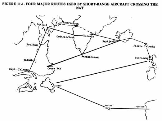
FIGURE 11-1. FOUR MAJOR ROUTES USED BY SHORT RANGE AIRCRAFT CROSSING THE NAT
(9) The four major routes used by short range aircraft to cross the NAT are depicted in Figure 11-1 above. All except the northern route require the installation of long range fuel tanks to satisfy the 3 hour reserve fuel requirement. In addition, each of these routes presents its own peculiar set of problems.
(a) The northern route is the longest route, but has the shortest overwater legs. It does, however, transverse long distances over remote, hostile, unpopulated terrain. This route for relatively short range aircraft normally follows a route that heads almost due north from Moncton to Sept-Isle to Shefferville to Kuujjuaq to Iqualuit (formerly known as Frobisher). At Iqualuit, the flight heads eastbound overwater to Greenland. Pilot reports from KuujJuaq indicate that there are times when fuel is not available at Kuujjuaq, and that quarters are primitive (if available at all). Once reaching Greenland, the route traverses the icecap, which can mean flying at FL 130 or higher. This presents the potential for cold temperature, icing, and severe weather. Pilots should expect no Loran C reception; good ADF tracking is essential.
(b) The direct route from Goose Bay, Labrador (CYRR) to Reykjavik, Iceland via Prins Christian Sund, Greenland NDB is one of the best routes with Narssarssuaq a midway alternate, although the NAT storm track can cause problems with wind and weather. This route means potential icing and weather problems over the Davis Straight (between Greenland and Iceland), plus coping with a demanding day only VFR approach. Loran C is unreliable at both ends of this approach, and there is steeply rising terrain on both sides and at the end of the approach.
(c) Gander, Newfoundland direct to Shannon, Ireland presents the usual problems of NAT severe weather, plus the significant effect that an unforecast wind shift can have on a slow aircraft flying a 1700 NM leg. In addition, the amount of extra fuel that would be used with even a 5 knot unanticipated headwind would be significant over such a long range. The one positive factor that favors this route is that Loran C coverage is continuous throughout the route.
(d) The route from St. John's, New Brunswick in Canada to Santa Maria in the Azores has the advantages of generally better weather and higher temperatures. The airport at Flores, located 300 NM west of Santa Maria, is a good alternate. The disadvantages are that Loran C coverage is not reliable for the whole distance, and an unforecast or unsuspected wind shift coupled with poor ADF equipment and/or procedures could mean missing the Azores altogether.
l. Additional Notes. Since icing is a severe hazard for light aircraft, temperatures should play a significant part in flight planning. June to September is the best time of year for all of the routes. At other times, the St. John's to Santa Maria route is the best choice because it overflies the Gulf Stream. An analysis of the most favored routes by professional ferry companies indicates that the route from Goose Bay direct to Reykjavik is the most popular, with the Santa Maria route being the next in popularity. However, it must be emphasized that most light aircraft need to have long range tanks installed to traverse these routes.
m. Flight Plans. Flight plans for international flights originating in Canada, flights in Europe, and flights entering Canada from overseas must be filed in the ICAO format. A sample ICAO flight plan is located in Appendix 1 of this AC. IFR (ICAO) flight plans are mandatory at or above FL 60 (6000 feet MSL in all oceanic CTAs, the Reykjavik FIR, and at or above FL 195 in the Sondrestrom. FIR (Greenland and off the coast of Greenland). Although VFR flight under the OCA (5500 MSL and below) is possible, there is little advantage in flying VFR. In fact, the Canadian government predicates their requirements upon the assumption that IFR will be encountered at some time during the flight. Therefore, it is prudent to take advantage of the flexibility, winds, safety factor, and navigation/communication radio reception of the higher altitudes afforded by an IFR flight.
n. Additional Canadian Inspection Notes. Transport Canada will no longer approve for transatlantic flight an aircraft fitted with a "placarded" ferry tank where it is obvious that the intent of the placarding is to avoid regulatory inspection of the installation, and issue of a Special Airworthiness Certificate for over-gross operation. A permanent waiver of the Canadian transoceanic inspection is available providing a pilot has successfully completed at least two inspections and transoceanic flights. However, a waivered pilot is still subject to spot checks by any NAT ICAO Provider State.
o. Canadian Customs Procedures. Pilots must land at a Canadian Customs authorized airport of entry (AOE), and a flight plan must be filed for all transborder operations. It should also be noted that VFR at night is not allowed, nor is VFR-on-top allowed in Canada. Canadian customs must receive notification in sufficient time to enable designated customs officers to inspect the aircraft.
3. OTHER CONSIDERATIONS.
a. Personal Physical Needs. These include nourishment, body comfort,
and provisions for biological relief. Certain foodstuffs are required for
Canadian departures, but all pilots should familiarize themselves of the
caloric content, sugar content, ease of access, digestibility and weight
of the food that they intend to use during flight. Foods should be high
in calories but low in sugar content. Sweets will provide the body with
an immediate energy lift but will dissipate in effectiveness very rapidly
and will have a tendency to create thirst. Biological relief is an extremely
important factor to consider. A pilot who has overextended his/her human
range (HR) can be distracted by pain to the point where intelligent decision
making and physical skills will deteriorate to the point of creating a
serious safety hazard. Pilots can increase HR by eating and drinking prudently
prior to each leg of the flight. Another consideration is that of body
comfort. Although watertight immersion suits are required for flights departing
Canada, this is only one form of protective clothing that should be considered.
The potential need to climb to a high altitude to escape detrimental winds
or to fly over the icecap in Greenland demands that the pilot has warm
clothing readily available and easily accessible. Glare is also a significant
hazard when flying above the clouds or flying over an icecap which indicates
that a pair of good sunglasses are an important consideration. Noise creates
a fatigue factor and should be reduced as much as possible. If not intending
to use a head set for the complete flight, pilots should have a set of
ear plugs available. The last consideration is extremely important if flights
above 10,000 feet are anticipated (as part of the planned flight or as
a possible contingency). This consideration is for oxygen requirements.
No matter what a pilot's health status happens to be, prolonged flights
above 10,000 feet without oxygen are an invitation to disaster.
b. The Aircraft. Fuel burn and the range of an aircraft are important considerations in the preflight planning stage of any trip, whether, international or domestic, and most pilots will take great care in ensuring that there is adequate fuel for a flight. One consideration, however, that is not quite so evident is oil usage. Domestically, one can make an emergency landing if some indication of excessive oil usage presents itself. On an oceanic flight, the preflight oil level is the maximum oil available for a trip leg unless some ingenious invention is devised to measure oil levels and to replenish the oil inflight. Because this situation is nearly impossible (early pilots were known to climb out on struts, etc., and replenish oil), it is advisable to make oceanic crossings only with aircraft that have engines which have not exceeded their half-life.
c. Equipment. Various equipment requirements including navigation and communication equipment are discussed in above sections of this Chapter. It is important, however, to make another equipment check: the condition of the magnetic compass, its accuracy, and the extreme variations that can be encountered in various sections of the world. Pilots should also review those turning errors that may have been forgotten since their last check ride.
d. Charts. When making a transoceanic flight, no one type of chart is totally adequate. It is important that the characteristics of various types of charts be known and carried. Some of these characteristics are itemized below.
(1) Jeppesen Plotting Charts. These charts have magnetic variation information, but the NAT charts have no radio navigation or topographic information although the Pacific charts do have the radio navigation frequencies. These charts do have up-to-date OCA boundaries, FIR, air defense identification zone (ADIZ), distant early warning identification zone (DEWIZ), and their required reporting points. The scale of these charts is 1: 10,000,000, and their size make them convenient for cockpit use.
(2) Defense Mapping Agency's Global Navigation Chart (GNC). These charts indicate variation, topography, ADIZ, and the location of VHF omnidirectional radio ranges (VOR) and NDBs. They do not have the FIR boundaries shown or the navigation frequencies listed.
(3) Global Loran C Charts (GLCC). These charts only contain Loran C information for navigation and isogonic lines. They do not depict topography, and the OCA information is not necessarily up-to-date.
(4) National Oceanic and Atmospheric Administration (NOAA) Route Charts. These charts are primarily designed for planners and controllers. Although not particularly useful to pilots, the charts do depict latitude and longitude information and the frequencies of some VORs and NDBs. These charts are particularly useful to pilots planning their first transoceanic flight because they cover a large geographical area and provide an excellent overview of the area to be overflown.
(5) Operational Navigation Charts (ONC). These charts are similar to the U.S. World Aeronautical Charts (WAC) and detail topographical features. They are extremely important to a pilot planning routes which have long legs over land masses (such as the route from Moncton to Frobisher).
(6) Approach Plates (Jeppesen or NOAA). On trips of the length required
for a transoceanic crossing, the potential for having to make an IFR approach
is a real possibility. These plates become a real necessity when one is
forced to make an unscheduled landing at an airport with a hazardous NDB
approach such as Narssarssuaq, Greenland. It would be nearly impossible,
even in an emergency, to try and make an approach to this airport without
any guidance. In fact, a note appears on the Jeppesen version of this approach
which states, "Caution: Pilots w/o a good knowledge of the local topographical
and met conditions are advised not to make any attempt to approach through
the fjords, unless ceiling at least 4000' and visibility 800 m." (2624.67
feet or approximately 1/2 mile). Approach plates should not only be carried
for airports of intended landing and alternate airports, but also for every
airport along the intended route of flight. Flight information publication
(FLIP) charts may be preferred by some pilots, but a word of caution is
needed regarding these charts: they do not depict every airport for which
an instrument approach is available.
e. Weather. Although pilots are required to have a knowledge of weather,
weather charts, and the procedures for accessing weather information, in
the United States weather information is readily accessible and easy to
decipher. On transoceanic flights weather information is often outdated,
difficult to obtain, and is in a format unique to the geographical area
in which it is disseminated. Pilots must hone those long forgotten skills
of interpreting charts and making their own prognosis of pending weather.
They must also be aware of all of the available sources of weather along
the route of their flight. Terminal area forecasts (TAFORS) are similar
to the U.S. terminal forecasts, and they are referred to as airport forecasts
(TAF). A complete listing of TAF codes is included in Appendix
1 of this AC. It is important that pilots have a knowledge of these
codes, and are able to interpret them and apply their meanings to an actual
flight situation.
FIGURE 11-2. GENERAL SAFETY NOTES
1. Know your aircraft. Pull cowling and inspect for leaks and check the general condition of the aircraft. The following aircraft components must be reviewed:
* Fuel system and management
* Radio equipment and condition
* Engine condition
* Oil consumption
* Oil pressure
* Oil temperature
* Instruments
2. Check compass on nearest runway heading to your course (use a compass rose if one is available):
* Swing compass with radios and navigation lights ON
* Check compass deviation with master switch OFF
* Check compass deviation with VHF OFF
* Check compass deviation with HF ON and then OFF
* Check compass deviation with pitot heat ON
* Check compass deviation with rotating beacon ON and then OFF Log
results of the above deviations
* Keep alternator load at or below 50 percent during compass testing,
if possible
* DO NOT assume that the compass card is accurate
3. ADF may be affected by the alternator, the VHF, the HF, the pitot heat, the rotating beacon, the autopilot, costal refraction, and atmospheric conditions. Check and recheck all navigation equipment under all operating conditions.
4. Enroute freezing levels should be 3000 feet AGL or higher to allow room for ridding aircraft of ice. If a departure must be made in below freezing temperature, it is imperative that the flight is in VFR conditions and clear of clouds until an area with higher freezing levels is reached.
5. Significant icing has been encountered at Goose Bay, Narssarssuaq, and Reykjavik as late in the year as early June.
6. The departure alternate should be VFR.
7. Destination weather should be well above IFR minimums and forecast to remain above minimum or improving. It is important to remember that after long flights at altitude, a pilot's capability to handle marginal weather will be in serious doubt. Personal weather minimums should be much higher than published minimums. An alternate airport should be selected with the-same minimums criteria.
8. Do not deviate from the flight plan unless the aircraft's position can be positively identified without navigation equipment. This prevents serious consequences in the event of radio failure.
9. Make all position reports when required, and report any problems to ATC as soon as possible. When reporting, it is prudent to provide ATC with a fuel remaining report in hours and minutes. Although not required, this information can be invaluable to ATC in the event of an emergency.
10. If in trouble, report the situation to ATC immediately by HF or
VHF on 121.5 MHz and request assistance. Do not wait to report. It might
take SAR an extended period of time to reach a troubled aircraft's position.
The aircraft should not deviate from its flight plan unless Air/Sea Rescue
advises the use of a new heading. If unable to make contact by radio, the
ELT should be manually activated.
FIGURE 11-2. GENERAL SAFETY NOTES - Continued
11. Air carrier traffic over the Atlantic is heavy. Do not hesitate to enlist the assistance of these aircraft in relaying a position fix, obtaining weather updates, or reporting an emergency. Air carriers are quite willing to assist anyone having difficulties and often their FL is high enough to relay communications. However, emergency frequencies should only be used for actual emergencies. It is acceptable to utilize emergency frequencies to make an initial contact, but only to request that someone communicate with the caller on another frequency.
12. Fatigue is a "sneaky" killer. A pilot often does not realize that he/she was fatigued until after an accident has taken place. Realistic work loads should be determined prior to commencing a flight and should not be exceeded unless an extreme emergency requires one to do so. The following situation is one in which it is very evident that fatigue contributed to a dual fatality.
A ferry pilot and his passenger departed Goose Bay in a Bonanza early one morning. They refueled in Reykjavik, then flew on to Scotland. The aircraft crashed 2 miles short of the runway at Glasgow, Scotland during a standard ILS approach. No severe weather existed and no aircraft problems were reported. Investigation revealed that all systems had been operating correctly and that the engine was running at the time of the crash. A synopsis of all factors involved indicated that pilot fatigue was the course of this accident.
No person shall fly an aircraft, nor should an operator require a person to fly an aircraft, when the person is suffering from fatigue or will encounter a workload that will induce fatigue.
13. Pilot reports (PIREPS) are significantly more important in remote
areas and in oceanic areas of operation. The absence of weather reporting
stations demands that pilots experiencing weather conditions that are likely
to affect the safety of other aircraft or other hazardous flight conditions,
report these to ATC as soon as possible.