1. GULF OF MEXICO.
a. Background. Although helicopter operations in the Gulf of Mexico have had an enviable safety record, recent statistics indicate that a significant rise in weather related accidents has occurred. It is imperative that pilots performing oceanic (offshore) operations do not exceed the minimum weather criteria for visual flight rules (VFR) and instrument flight rules (IFR) flight or the minimum flight altitude parameters for all phases of flight. The operator must comply with all applicable minimum equipment requirements for the operation.
Two documents that address issues and requirements for improving rotorcraft operations within the National Airspace System are "Rotorcraft Terminal ATC Route Standards" (FAA/RD-90/18) and "Rotorcraft Enroute ATC Route Standards" (FAA/RD-90-19). These documents are available to the public through the National Technical Information Service, Springfield, Virginia 22161. All operators should obtain these two documents and ensure that crews are familiar with the operating procedures discussed in these documents.
b. Flight in Environmentally Sensitive Areas. Protection of endangered species and the overflight of environmentally sensitive areas are of increasing concern in the Gulf of Mexico. Infringements by low flying airplanes and/or rotorcraft operating enroute to airways in the Gulf of Mexico or to helidecks can be disruptive to wildlife while over the shore or near the shore. Guidelines for flights in these areas are contained in the Airman's Information Manual (AIM) {Should be Aeronautical Information Manual - Ed.}, in Advisory Circular (AC) 91-36 "VFR Flight Near Noise Sensitive Areas," on VFR sectional maps, and on specially designed maps published by Minerals Management Service of the Department of the Interior.
2. IFR OFFSHORE OPERATIONS.
a. General. Any operator that desires to conduct IFR operations in uncontrolled airspace shall submit a letter describing the proposed operation to the certificate holding district office (CHDO). This letter should include the specific routes to be flown, the exact location of the destination, the type of aircraft to be used, the navigation equipment on the aircraft, and the specific navigational aids (navaids) to be used at the offshore facility, if any.
b. Offshore Operators. FAR Part 91 offshore operators are required to obtain a Letter of Authorization (LOA) for IFR operations. The LOA will be issued once all certification requirements are met.
c. FAA Coordination. After reviewing the request, the CHDO will arrange a coordination meeting with air traffic elements that will be involved (such as the center, approach control, flight service station (FSS), etc.). If a navaid exists at the offshore facility, the regional flight procedures branch may also be represented at the coordination meeting. If the proposed operations are to be conducted in a region other than that of the CHDO, the CHDO will coordinate with the FSDO having jurisdiction of the geographic area where operations are to be conducted. The jurisdictional flight standards district office (FSDO) will perform route checks and other required inspections, and forward reports of these inspections to the CHDO. When all requirements have been met, the CHDO approves the operation and issues operation specifications or an LOA.
d. Navigation Requirements and Procedures. Operators will be inspected to ensure that the required navigational equipment, including radar altimeter and mapping radar, is appropriately installed and approved for the proposed operation. If flight routes are predicated on the use of an area navigation (RNAV) system, operators should ensure dud they are in compliance with AC 90-45, "Approval of Area Navigation Systems for use in the U.S. National Airspace System." An operator that seeks approval for IFR operations must ensure dug the following navigation requirements are met.
(1) Route Requirements. Operators may develop proposed routes using Class I station referenced navaids where adequate signal coverage is available. In areas where signal coverage is not available, the operator must provide a suitable means of Class II navigation. The FAA will require a validation test in VFR conditions to ensure that the operator is able to demonstrate adequate navigational performance for the route(s) before granting approval for use of the route(s).
(a) For approval of IFR operations using Class I navaids, appropriate approach plates and operating procedures must be approved by the FAA and published in the operator's manual. Use of the procedures will be authorized through a nonstandard operations specifications paragraph that refers to the operator's manual containing these procedures.
(b) For approval of IFR operations using nonterminal navaid facilities, the operator must submit a written request to the CHDO for a helicopter offshore procedure according to AC 90-80, "Approval of Offshore Helicopter Approaches."
(2) Extended Overwater or IFR Operations Equipment. All navigation equipment to be used in extended overwater or IFR operations must meet FAR 135.165(b) requirements. If positive course guidance for any portion of the route is obtained through the use of long range navigation equipment such as very low frequency (VLF), Omega, or Loran C, two independent receivers for navigation must be installed and be operative before approval is granted.
e. Weather Reporting Requirements. A weather reporting facility approved by the National Weather Service (NWS) or the FAA must be present and operable within 10 nautical miles (NM) of the destination. A remote source may be approved by the FAA (with NWS concurrence) as a deviation from the provisions of FAR 135.213(b) when the operator is able to demonstrate an adequate level of safety for the proposed operations. The approval for this deviation will be published in the operation specifications.
f. Helicopter Enroute Descent Areas (HEDA). An operator that desires to establish a HEDA shall submit a written request to its CHDO. If the proposed HEDA is outside the CHDO's geographic area of responsibility, the CHDO will forward the request to the jurisdictional FSDO. The letter of request should include the following information:
(1) A pictorial and/or a written description of the proposed HEDA
(2) The means by which positive course guidance is to be established
(3) Equipment requirements for use in the HEDA
(4) Proposed operations and training manual revisions to incorporate HEDAs, if an initial application for approval of a HEDA
(5) The date of first intended use and the proposed length of service for which authorization is sought
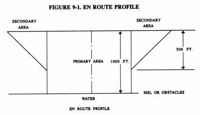
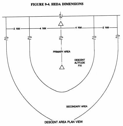
g. HEDA Procedures and Requirements. Prior to granting authorization, the CHDO or jurisdictional FSDO will coordinate with a flight inspection procedures specialist to determine if the proposed HEDA is clear of obstructions and that positive course guidance is available for the entire route, including descent to the lowest authorized altitude (LAA). All required flight and navigation equipment must be installed and operative to utilize the 400-foot minimum. Figures 9-1 and 9-2 portray the enroute dimensions contained in FAA Order 8260.3, "U.S. Standards for Terminal Instrument Procedures," that should be used to develop the primary and secondary areas for HEDA use. HEDA's have the profile of Figure 9-3 and the dimensions of the plan view as shown in Figure 9-4. The descent area begins at the descent fix and ends at the descent altitude fix. This area must be located over water and be free of obstacles.
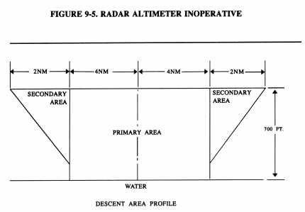
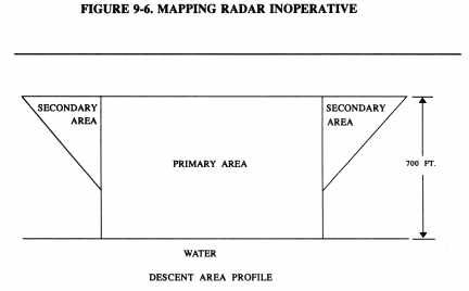
(1) Inoperative Equipment.
(a) The LAA will be increased to 700 feet as shown in Figure 9-5 with the radar altimeter inoperative.
(b) The LAA will be increased to 700 feet as shown in Figure 9-6 with the mapping radar inoperative.
(c) When the radar altimeter is inoperative, altitude will be adjusted upward 5 feet for each mile over 5 miles from the altimeter setting source to the descent altitude fix.
(2) Operations specifications for HEDAs are valid for 1 calendar year from the date of issue. Operators wishing to obtain HEDA revalidation must submit written confirmation to the CHDO that the HEDA is clear of obstructions and that positive course guidance is available. The operator must provide the means for any on-site inspections requested by the CHDO or FSDO.
FIGURE 9-1. ENROUTE PROFILE}
FIGURE 9-2. ENROUTE PLAN VIEW
FIGURE 9-3. HEDA PROFILE
FIGURE 9-4. HEDA DIMENSIONS
FIGURE 9-5. RADAR ALTIMETER INOPERATIVE
FIGURE 9-6. MAPPING RADAR INOPERATIVE
3. OFFSHORE INSTRUMENT APPROACH PROCEDURES.
a. General. These procedures are to be used by IFR approved helicopter operators in an offshore environment to conduct instrument approaches to rigs, platforms, or ships that are at least 5 NM offshore in uncontrolled airspace. The helicopter will use the airborne radar approaches (ARA) or the offshore standard approach procedures (OSAP) for conducting instrument approaches in this environment.
b. Approach Approval Procedures. AC 90-80, "Approval of Airborne Radar Approach (ARA) Procedures for Helicopters to Offshore Platforms," contains approval guidance, procedures criteria, and a sample training program for offshore instrument approaches. ARA procedures are special instrument approach procedures approved under the provisions of FAA Order 8260.19, "Flight Procedures and Airspace," and FAA Order 8260.3.
(1) ARA Approval Procedures.
(a) The FSDO with geographic responsibility for the area in which the ARA will be conducted must verify the adequacy of obstacle clearances.
(b) Operators must demonstrate acceptable performance of enroute and instrument approach procedures to the CHDO prior to the operator's obtaining approval to use these procedures.
(c) ARAs are documented on FAA Form 8260-7,"Special Instrument Approach Procedures."
(d) The FAA regional flight inspection and procedures (FIP) staff will inspect ARAs prior to approval by the CHDO. Minor changes of rig locations will be made in pen and ink, provided the enroute egress point and procedures remain the same and the controlling obstacle does not change. Otherwise, the FIP staff will develop a new procedure.
(2) OSAP Approval Procedures.
(a) Operators that desire to conduct OSAP's must submit a written request to the CHDO according to the procedures stated in AC 90-80, as amended.
(b) The procedures contained in the request for approval will be evaluated and tested by the CHDO. Additionally, the operator's maintenance and training programs will be inspected prior to issuance of the authorization.
(c) Authorization for FAR Part 135 operators to conduct OSAPs will be made as part of the operations specifications.
(d) Authorization for FAR Part 91 operators to conduct OSAPs will be
issued in an LOA (Figure 9-6)
FIGURE 9-7. SAMPLE LETTER OF AUTHORIZATION (LOA)
(Figure 9-7 is a sample LOA from AC 90-80, Appendix 5.)
January 20, 1993
Energy Resources, Inc.
1234 Fifth Avenue
Wellhead, LA 98765
Gentlemen:
Energy Resources, Inc. is authorized to conduct helicopter offshore standard approach procedures (OSAP) under Federal Aviation Regulations (FAR) Part 91 within the areas listed in this letter. Energy Resources, Inc. shall conduct all OSAP operations in compliance with the conditions, limitations, and procedures in this letter and shall conduct no other OSAP operations.
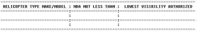
(a) Energy Resources, Inc. is authorized to use the following OSAP approach
and landing minimums for the helicopters listed in the following table,
provided that the conditions and limitations in paragraphs (b) and (e)
are met.
|
(b) The flight instruments, radio navigation, and other airborne systems
required by the applicable FAR must be installed and must be operational
for OSAP operations. The airborne radar, Loran C, and radar altimeter equipment
listed in the following table is also required and, except for the radar
altimeter, must be operational for OSAP operations.
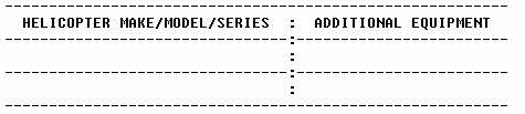 |
(c) Energy Resources, Inc. shall not conduct any OSAP operations unless an approved source of weather observations (including wave height) is located within 10 nautical miles of the approach target to which a particular OSAP is oriented, or extended operations are approved using enhanced weather information systems.
(d) No pilot or airborne radar operator shall conduct any OSAP operations in any helicopter unless that person has successfully completed the Energy Resources, Inc. training program and has been certified by an FAA inspector as qualified for OSAP operations.
(e) No pilot in command shall begin or continue the final approach segment of an OSAP unless all of the following conditions and limitations are met:
(1) the maximum indicated airspeed does not exceed 90 knots
(2) the maximum groundspeed does not exceed 70 knots (never slower than Vyse for multiengine helicopters) between the decision point altitude (DPA) and the missed approach point (MAP)
(3) there is no indication on the weather radar display of contouring due to the intensity of precipitation
(4) all obstructions that are observed on radar are avoided by at least 0.5 NM when below 900 feet MSL during a takeoff and departure procedure
(5) whenever a required radar altimeter is inoperative, the MDA must be increased by 5 feet for each NM in excess of 5 NM distance between the approach target and an approved altimeter setting source
(f) A missed approach shall be executed when any of the following conditions exist:
(1) any of the airborne equipment (other than a radar altimeter) required for the OSAP operations becomes inoperative
(2) at least 0.5 NM lateral separation from obstacles cannot be maintained after passing the DPA
(3) the approach target disappears from the radar display
(4) the reliability or accuracy of the Loran C signal cannot be ascertained
(5) whenever the approach target is not in visual contact at any distance less than 0.7 NM
[Signed by the FSDO or CHDO office manager]