3-2
| Altimeter
The altimeter measures the height of the airplane above a given level.
Since it is the only instrument that gives altitude information, the altimeter
is one of the most important instruments in the airplane. To use the altimeter
effectively, the pilot must thoroughly understand its principle of operation
and the effect of atmospheric pressure and temperature on the altimeter.
[Figure 3-2] |
 |
|
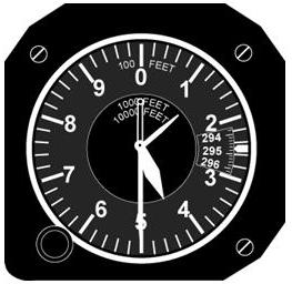
Figure 3-2.—Sensitive altimeter. The instrument is adjusted by the
knob (lower left) so the current altimeter setting (29.48) appears in the
window to the right. |
Principle of Operation
The pressure altimeter is simply an aneroid barometer that measures
the pressure of the atmosphere at the level where the altimeter is located,
and presents an altitude indication in feet. The altimeter uses static
pressure as its source of operation. Air is more dense at the surface of
the Earth than aloft, therefore as altitude increases, atmospheric pressure
decreases. This difference in pressure at various levels causes the altimeter
to indicate changes in altitude.
The presentation of altitude varies considerably between different
types of altimeters. Some have one pointer while others have more. Only
the multipointer type will be discussed in this handbook.
The dial of a typical altimeter is graduated with numerals arranged
clockwise from 0 to 9 inclusive as shown in figure 3-2. Movement of the
aneroid element is transmitted through a gear train to the three hands
which sweep the calibrated dial to indicate altitude. The shortest hand
indicates altitude in tens of thousands of feet; the intermediate hand
in thousands of feet; and the longest hand in hundreds of feet, subdivided
into 20-foot increments.
This indicated altitude is correct, however, only if the sea level
barometric pressure is standard (29.92 in. Hg.), the sea level free air
temperature is standard (+15° C or 59° F), and furthermore, the
pressure and temperature decrease at a standard rate with an increase in
altitude. Since atmospheric pressure continually changes, a means is provided
to adjust the altimeter to compensate for nonstandard conditions. This
is accomplished through a system by which the altimeter setting (local
station barometric pressure reduced to sea level) is set to a barometric
scale located on the face of the altimeter. Only after the altimeter is
set properly will it indicate the correct altitude.
Effect of Nonstandard Pressure and Temperature
If no means were provided for adjusting altimeters to nonstandard
pressure, flight could be hazardous. For example, if a flight is made from
a high pressure area to a low pressure area without adjusting the altimeter,
the actual altitude of the airplane will be LOWER than the indicated altitude,
and when flying from a low pressure area to a high pressure area, the actual
altitude of the airplane will be HIGHER than the indicated altitude. Fortunately,
this error can be corrected by setting the altimeter properly.
Variations in air temperature also affect the altimeter. On a
warm day, the expanded air is lighter in weight per unit volume than on
a cold day, and consequently the pressure levels are raised. For example,
the pressure level where the altimeter indicates 10,000 feet will be HIGHER
on a warm day than under standard conditions. On a cold day, the reverse
is true, and the 10,000-foot level would be LOWER. The adjustment made
by the pilot to compensate for nonstandard pressures does not compensate
for nonstandard temperatures. Therefore, if terrain or obstacle clearance
is a factor in the selection of a cruising altitude, particularly at higher
altitudes, remember to anticipate that COLDER-THAN-STANDARD TEMPERATURE
will place the aircraft LOWER than the altimeter indicates. Therefore,
a higher altitude should be used to provide adequate terrain clearance.
A memory aid in applying the above is “from a high to a low or
hot to cold, look out below.”
Setting the Altimeter
To adjust the altimeter for variation in atmospheric pressure,
the pressure scale in the altimeter setting window, calibrated in inches
of mercury (in. Hg.), is adjusted to correspond with the given altimeter
setting. Altimeter settings can be defined as station pressure reduced
to sea level, expressed in inches of mercury.
The station reporting the altimeter setting takes an hourly measurement
of the station’s atmospheric pressure and corrects this value to sea level
pressure. These altimeter settings reflect height above sea level only
in the vicinity of the reporting station. Therefore, it is necessary to
adjust the altimeter setting as the flight progresses from one station
to the next.
14 CFR part 91 provides the following concerning altimeter settings:
The cruising altitude of an aircraft below 18,000 feet mean sea level (MSL)
shall be maintained by reference to an altimeter that is set to the current
reported altimeter setting of a station located along the route of flight
and within 100 nautical miles (NM) of the aircraft. If there is no such
station, the current reported altimeter setting of an appropriate available
station shall be used. In an aircraft having no radio, the altimeter shall
be set to the elevation of the departure airport or an appropriate altimeter
setting available before departure.
Many pilots confidently expect that the current altimeter setting
will compensate for irregularities in atmospheric pressure at all altitudes.
This is not always true because the altimeter setting broadcast by ground
stations is the station pressure corrected to mean sea level. The altimeter
setting does not account for the irregularities at higher levels, particularly
the effect of nonstandard temperature.
It should be pointed out, however, that if each pilot in a given
area were to use the same altimeter setting, each altimeter will be equally
affected by temperature and pressure variation errors, making it possible
to maintain the desired separation between aircraft.
When flying over high mountainous terrain, certain atmospheric
conditions can cause the altimeter to indicate an altitude of 1,000 feet,
or more, HIGHER than the actual altitude. For this reason, a generous margin
of altitude should be allowed—not only for possible altimeter error, but
also for possible downdrafts which are particularly prevalent if high winds
are encountered.
To illustrate the use of the altimeter setting system, follow
a flight from Love Field, Dallas, Texas, to Abilene Municipal Airport,
Abilene, Texas, via Mineral Wells. Before takeoff from Love Field, the
pilot receives a current altimeter setting of 29.85 from the control tower
or automatic terminal information service (ATIS). This value is set in
the altimeter setting window of the altimeter. The altimeter indication
should then be compared with the known airport elevation of 485 feet. Since
most altimeters are not perfectly calibrated, an error may exist. If an
altimeter indication varies from the field elevation more than 75 feet,
the accuracy of the instrument is questionable and it should be referred
to an instrument technician for recalibration.
When over Mineral Wells, assume the pilot receives a current altimeter
setting of 29.94 and applies this setting to the altimeter. Before entering
the traffic pattern at Abilene Municipal Airport, a new altimeter setting
of 29.69 is received from the Abilene Control Tower, and applied to the
altimeter. If the pilot desires to fly the traffic pattern at approximately
800 feet above terrain, and the field elevation of Abilene is 1,778 feet,
an indicated altitude of 2,600 feet should be maintained (1,778 feet +
800 feet = 2,578 feet rounded to 2,600 feet).
The importance of properly setting and reading the altimeter cannot
be overemphasized. Let’s assume that the pilot neglected to adjust the
altimeter at Abilene to the current setting, and uses the Mineral Wells
setting of 29.94. If this occurred, the airplane, when in the Abilene traffic
pattern, would be approximately 250 feet below the proper traffic pattern
altitude of 2,600 feet, and the altimeter would indicate approximately
250 feet more than the field elevation (2,028 feet) upon landing.
Actual altimeter setting 29.94
Proper altimeter setting 29.69
Difference .25
(1 inch of pressure is equal to approximately 1,000 feet of altitude—.25
x 1,000 feet = 250 feet)
The above calculation may be confusing, particularly in determining
whether to add or subtract the amount of altimeter error. The following
additional explanation is offered and can be helpful in finding the solution
to this type of problem.
There are two means by which the altimeter pointers can be moved.
One utilizes changes in air pressure while the other utilizes the mechanical
makeup of the altimeter setting system.
When the aircraft altitude is changed, the changing pressure within
the altimeter case expands or contracts the aneroid barometer which through
linkage rotates the pointers. A decrease in pressure causes the altimeter
to indicate an increase in altitude, and an increase in pressure causes
the altimeter to indicate a decrease in altitude. It is obvious then that
if the aircraft is flown from a pressure level of 28.75 in. Hg. to a pressure
level of 29.75 in. Hg., the altimeter would show a decrease of approximately
1,000 feet in altitude.
The other method of moving the pointers does not rely on changing
air pressure, but the mechanical construction of the altimeter. When the
knob on the altimeter is rotated, the altimeter setting pressure scale
moves simultaneously with the altimeter pointers. This may be confusing
because the numerical values of pressure indicated in the window increase
while the altimeter indicates an increase in altitude; or decrease while
the altimeter indicates a decrease in altitude. This is contrary to the
reaction on the pointers when air pressure changes, and is based solely
on the mechanical makeup of the altimeter. To further explain this point,
assume that the proper altimeter setting is 29.50 and the actual setting
is 30.00 or a .50 difference. This would cause a 500-foot error in altitude.
In this case if the altimeter setting is adjusted from 30.00 to 29.50,
the numerical value decreases and the altimeter indicates a decrease of
500 feet in altitude. Before this correction was made, the aircraft was
flying at an altitude of 500 feet lower than was shown on the altimeter.
Types of Altitude
Knowing the aircraft’s altitude is vitally important to the pilot
for several reasons. The pilot must be sure that the airplane is flying
high enough to clear the highest terrain or obstruction along the intended
route; this is especially important when visibility is restricted. To keep
above mountain peaks, the pilot must note the altitude of the aircraft
and elevation of the surrounding terrain at all times. To reduce the possibility
of a midair collision, the pilot must maintain altitudes in accordance
with air traffic rules. Often certain altitudes are selected to take advantage
of favorable winds and weather conditions. Also, a knowledge of the altitude
is necessary to calculate true airspeeds.
Altitude is vertical distance above some point or level used as
a reference. There may be as many kinds of altitude as there are reference
levels from which altitude is measured and each may be used for specific
reasons. Pilots are usually concerned, however, with five types of altitudes:
• Absolute Altitude—The vertical distance of an aircraft above the terrain.
• Indicated Altitude—That altitude read directly from the altimeter
(uncorrected) after it is set to the current altimeter setting.
• Pressure Altitude—The altitude indicated when the altimeter setting
window (barometric scale) is adjusted to 29.92. This is the standard datum
plane, a theoretical plane where air pressure (corrected to 15° C)
is equal to 29.92 in. Hg. Pressure altitude is used for computer solutions
to determine density altitude, true altitude, true airspeed, etc.
• True Altitude—The true vertical distance of the aircraft above sea
level—the actual altitude. (Often expressed in this manner; 10,900 feet
MSL.) Airport, terrain, and obstacle elevations found on aeronautical charts
are true altitudes.
• Density Altitude—This altitude is pressure altitude corrected for
nonstandard temperature variations. When conditions are standard, pressure
altitude and density altitude are the same. Consequently, if the temperature
is above standard, the density altitude will be higher than pressure altitude.
If the temperature is below standard, the density altitude will be lower
than pressure altitude. This is an important altitude because it is directly
related to the aircraft’s takeoff and climb performance.