5-4
MOISTURE AND TEMPERATURE
The atmosphere always contains a certain amount of foreign matter—smoke,
dust, salt particles, and particularly moisture in the form of invisible
water vapor. The amount of moisture that can be present in the atmosphere
depends upon the temperature of the air. For each increase of 20° F,
the capacity of the air to hold moisture is about doubled; conversely,
for each decrease of 20° F, the capacity becomes only half as much.
Relative Humidity
“Humidity” is commonly referred to as the apparent dampness in
the air. A similar term used by the National Weather Service, is relative
humidity, which is a ratio of the amount of moisture present in any given
volume of air to the amount of moisture the air could hold in that volume
of air at prevailing temperature and pressure. For instance, “75 percent
relative humidity,” means that the air contains three-fourths of the water
vapor which it is capable of holding at the existing temperature and pressure.
Temperature/Dewpoint Relationship
For the pilot, the relationship discussed under relative humidity
is expressed in a slightly different way—as “temperature and dewpoint.”
It is apparent from the foregoing discussion that if a mass of air at 27°
C (80° F) has a relative humidity of 50 percent and the temperature
is reduced 11° C (20° F) to 16° C (60° F), the air will
then be saturated (100 percent relative humidity). In this case, the original
relationship will be stated as “temperature 80° F, dewpoint 60.” In
other words, dewpoint is the temperature to which air must be cooled to
become saturated.
Dewpoint is of tremendous significance to the pilot because it
represents a critical condition of the air. When temperature reaches the
dewpoint, water vapor can no longer remain invisible, but is forced to
condense, becoming visible on the ground as dew or frost, appearing in
the air as fog or clouds, or falling to the Earth as rain, snow, or hail.
NOTE: This is how water can get into the fuel tanks when the tanks are
left partially filled overnight. The temperature cools to the dewpoint,
and the water vapor contained in the fuel tank air space condenses. This
condensed moisture then sinks to the bottom of the fuel tank, since water
is heavier than gasoline.
Methods by Which Air Reaches the Saturation Point
It is interesting to note the various ways by which air can reach
the saturation point. As previously discussed, this is brought about by
a lowering of temperature such as might occur when warm air moves over
a cold surface, when cold air mixes with warm air, when air is cooled during
the night by contact with the cold ground, or when air is forced upward.
Only the fourth method needs any special comment.
When air rises, it uses heat energy in expanding. Consequently,
the rising air loses heat rapidly. If the air is unsaturated, the loss
will be approximately 3.0° C (5.4° F) for every 1,000 feet of altitude.
Warm air can be lifted aloft by three methods; by becoming heated
through contact with the Earth’s surface, resulting in convective currents;
by moving up sloping terrain (as wind blowing up a mountainside); and by
being forced to flow over another body of air. For example, when air masses
of different temperatures and densities meet. Under the last condition,
the warmer, lighter air tends to flow over the cooler, denser air. This
will be discussed in greater detail in this chapter under “Air Masses and
Fronts.”
Air can also become saturated by precipitation. Whatever the cause,
when temperature and dewpoint at the ground are close together, there is
a good possibility for low clouds and fog to form.
Effect of Temperature on Air Density
Atmospheric pressure not only varies with altitude, it also varies
with temperature. When air is heated, it expands and therefore has less
density. A cubic foot of warm air is less dense than a cubic foot of cold
air. This decrease in air density (increase in density altitude), brought
about by an increase in temperature, has a pronounced effect on flight.
Effect of Temperature on Flight
Since an increase in temperature makes the air less dense (increases
density altitude), the takeoff run will be longer, the rate of climb slower,
and the landing speed (groundspeed) faster on a hot day than on a cold
day. Thus, an increase in temperature has the same effect as an increase
in altitude. An airplane which requires a ground run of 1,000 feet on a
winter day when the temperature is –18° C (0° F), will require
a much longer run on a summer day when the temperature is 38° C (100°
F). An airplane that requires the greater portion of a short runway for
takeoff on a cold winter day may be unable to take off on this runway during
a hot summer day.
Effect of High Humidity on Air Density
A common misconception is that water vapor weighs more than an
equal volume of dry air. This is not true. Water vapor weighs approximately
five-eighths or 62 percent of an equal volume of perfectly dry air. When
the air contains moisture in the form of water vapor, it is not as heavy
as dry air and so is less dense.
Assuming that temperature and pressure remain the same, the air
density varies inversely with the humidity—that is, as the humidity increases,
the air density decreases, (density altitude increases); and, as the humidity
decreases, the air density increases (density altitude decreases).
The higher the temperature, the greater the moisture-carrying
ability of the air. Therefore, air at a temperature of 38° C (100°
F) and a relative humidity of 80 percent will contain a greater amount
of moisture than air at a temperature of 16° C (60° F) and a relative
humidity of 80 percent.
Effect of High Humidity on Flight
Since high humidity makes the air less dense (increases density
altitude), the takeoff roll will be longer, rate of climb slower, and landing
speed higher.
When all three conditions are present, the problem is aggravated.
Therefore, beware of “high, hot, and humid” conditions (high density altitudes),
and take the necessary precautions, by using performance charts, to assure
the runway is long enough for takeoff.
Dew and Frost
When the ground cools at night, the temperature of the air immediately
adjacent to the ground is frequently lowered to the saturation point, causing
condensation. This condensation takes place directly upon objects on the
ground as dew if the temperature is above freezing, or as frost if the
temperature is below freezing.
Dew is of no importance to aircraft, but frost creates friction
which interferes with the smooth flow of air over the wing surfaces, resulting
in a higher stall speed. Frost should always be removed before flight.
| Fog
When the air near the ground is four or five degrees above the dewpoint,
the water vapor condenses and becomes visible as fog. There are many types
of fog, varying in degree of intensity and classified according to the
particular phenomena which cause them. One type, “ground fog,” which frequently
forms at night in low places, is limited to a few feet in height, and is
usually dissipated by the heat of the Sun shortly after sunrise. Other
types, which can form any time conditions are favorable, may extend to
greater heights and persist for days or even weeks.
|
|
|
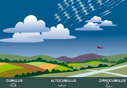
Figure 5-18.—Cumulus clouds as they appear at low, intermediate,
and high levels. |
 |
Along seacoasts fog often forms over the ocean and is blown inland.
All types of fog produce low visibility and therefore constitute a serious
hazard to aircraft.
Clouds
There are two fundamental types of clouds. First, those formed by vertical
currents carrying moist air upward to its condensation point are lumpy
or billowy and are called “cumulus,” which means an “accumulation” or a
“pile.” Second, those which develop horizontally and lie in sheets or formless
layers like fog are called “stratus,” which means “spread out.” [Figures
5-18 and 5-19] |
| Figure 5-19.—Stratus-type clouds at various altitudes. |
|
When clouds are near the Earth’s surface, they are generally designated
as “cumulus” or “stratus” unless they are producing precipitation, in which
case the word “nimbus” (meaning “rain cloud”) is added—as “nimbostratus”
or “cumulonimbus.” [Figure 5-20]
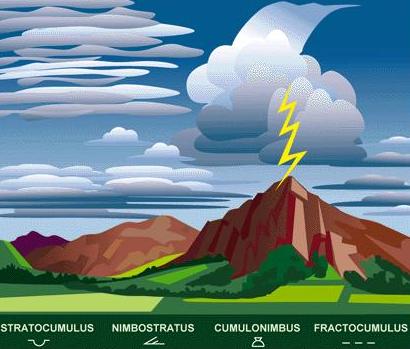 |
If the clouds are ragged and broken, the word “fracto” (meaning “broken”)
is added—as “fractostratus” or “fractocumulus.”
The word “alto” (meaning “high”) is generally added to designate
clouds at intermediate heights, usually appearing at levels of 5,000 to
20,000 feet—as “altostratus” or “altocumulus.”
Clouds formed in the upper levels of the troposphere (commonly
between 20,000 and 50,000 feet) are composed of ice crystals and generally
have a delicate, curly appearance, somewhat similar to frost on a windowpane.
For these clouds, the word “cirro” (meaning “curly”) is added—as “cirrocumulus”
or “cirrostratus.” At these high altitudes, there is also a fibrous type
of cloud appearing as curly wisps, bearing the single name “cirrus.” |
| Figure 5-20.—Various types of bad weather clouds. |
|
Under “Air Masses and Fronts” the relationship will be shown between
the various types of clouds and the kind of weather expected. At present
the chief concern is with the flying conditions directly associated with
the different cloud formations.
The ice-crystal clouds (cirrus group) are well above ordinary
flight levels of light aircraft and normally do not concern the pilots
of these aircraft, except as indications of approaching changes in weather.
The clouds in the “alto” group are not normally encountered in flights
of smaller planes, but they sometimes contain icing conditions important
for commercial and military planes. Altostratus clouds usually indicate
that unfavorable flying weather is near.
The low clouds are of great importance to the pilot because they
create low ceilings and low visibility. They change rapidly, and frequently
drop to the ground, forming a complete blanket over landmarks and landing
fields. In temperatures near freezing, they are a constant threat because
of the probability of icing. The pilot should be constantly alert to any
changes in conditions, and be prepared to land before visibility lowers
to the point where objects are suddenly obscured.
Cumulus clouds vary in size from light “scud” or fluffy powder
puffs to towering masses rising thousands of feet in the sky. Usually they
are somewhat scattered, and the pilot can fly around them without difficulty.
Under some conditions, particularly in the late afternoon, they are likely
to multiply, flatten out, and cover the sky.
Cumulonimbus clouds are very dangerous. When they appear individually
or in small groups, they are usually of the type called “air mass thunderstorms”
(caused by heating of the air at the Earth’s surface) or “orographic thunderstorms”
(caused by the upslope motion of air in mountainous regions). On the other
hand, when these clouds take the form of a continuous or almost continuous
line, they are usually caused by a front or squall line. The most common
position for a squall line is in advance of a cold front, but one can form
in air far removed from a front.
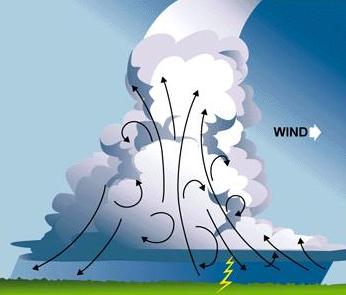
| Since cumulonimbus clouds are formed by rising air currents,
they are extremely turbulent; moreover, it is possible for an airplane
flying nearby to be drawn into the cloud. Once inside, an airplane may
encounter updrafts and downdrafts with velocities of 3,000 feet per minute
or greater. Airplanes have been torn apart by the violence of these currents.
In addition, the clouds frequently contain large hailstones capable of
severely damaging aircraft, lightning, and great quantities of water at
temperatures conducive to heavy icing. The only practical procedure for
a pilot caught within a thunderstorm is to reduce airspeed. A recommended
safe speed for an airplane flying through turbulence is an airspeed which
provides a safe margin above the stall speed, but not greater than the
maneuvering speed for the particular airplane. |
|
|
Figure 5-21.—Cross-section of a cumulonimbus cloud (thunderhead). |
Figure 5-21 shows the important characteristics of a typical cumulonimbus
cloud. The top of the cloud flattens into an anvil shape, which points
in the direction the cloud is moving, generally with the prevailing wind.
Near the base, however, the winds blow directly toward the cloud and increase
in speed, becoming violent updrafts as they reach the low rolls at the
forward edge.
Within the cloud and directly beneath it are updrafts and downdrafts.
In the rear portion is a strong downdraft which becomes a wind blowing
away from the cloud.
The cloud is a storm factory. The updrafts quickly lift the moist
air to its saturation point, whereupon it condenses and raindrops begin
to fall. Before these have reached the bottom of the cloud, updrafts pick
them up and carry them aloft, where they may freeze and again start downward,
only to repeat the process many times until they have become heavy enough
to break through the updrafts and reach the ground as hail or very large
raindrops. As the storm develops, more and more drops fall through the
turbulence, until the rain becomes fairly steady. The lightning that accompanies
such a storm is probably due to the breakup of raindrops. This produces
static electricity that discharges as lightning, thus causing sudden expansion
of the air in its path, resulting in thunder.
It is impossible for a small plane to fly over these clouds because
they frequently extend to 50,000 feet and are usually too low to fly under.
If they are close together, there may be violent turbulence in the clear
space between them. If they are isolated thunderstorms, it usually is possible
to fly around them safely by remaining a good distance from them. If, however,
they are “frontal” or squall line storms, they may extend for hundreds
of miles, and the only safe procedure is to land as soon as possible and
wait until the cumulonimbus cloud formation has passed.
Ceiling
A ceiling for aviation purposes is the lowest broken, overcast
layer, or vertical visibility into an obscuration. Clouds are reported
as broken when they cover five-eighths to seven-eighths of the sky, and
as overcast when they cover eight-eighths of the sky. The latest information
on ceilings can be obtained from an aviation routine weather report (METAR).
Forecasts of expected changes in ceilings and other conditions also are
available at weather stations.
Visibility
Closely related to ceiling and cloud cover is “visibility”—the
greatest horizontal distance at which prominent objects can be distinguished
with the naked eye. Visibility, like ceiling, is included in hourly weather
reports and in aviation forecasts.
Precipitation
In addition to possible damage by hail and the danger of icing,
precipitation may be accompanied by low ceilings, and in heavy precipitation
visibility may suddenly be reduced to zero.
It should be obvious that aircraft, which may have accumulated
snow while on the ground, should never be flown until all traces of snow
have been removed, including the hard crust that frequently adheres to
the surfaces. An aircraft, which has been exposed to rain, followed by
freezing temperatures, should be carefully cleared of ice and checked before
takeoff to make certain that the controls operate freely.