Separate aircraft by one of the following methods:
a. Clear aircraft on different airways or routes whose widths
or protected airspace do not overlap.
b. Clear aircraft below 18,000 to proceed to and report over
or hold at different geographical locations determined visually or by reference
to NAVAIDs.
c. Clear aircraft to hold over different fixes whose holding
pattern airspace areas do not overlap each other or other airspace to be
protected.
d. Clear departing aircraft to fly specified headings which diverge
by at least 45 degrees.
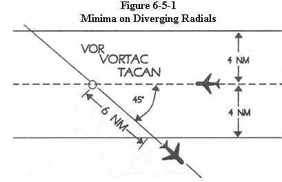
6-5-2 Minima on Diverging Radials.
a. Consider separation to exist between aircraft established on
radials of the same NAVAID that diverge by at least 15 degrees when either
aircraft is clear of the airspace to be protected for the other aircraft.
|
NOTE -
The procedure may be applied to converging as well as diverging aircraft.
(See Figure 6-5-1). The aircraft depicted 6 miles from the NAVAID would
require vertical separation until reaching the 6-mile point. Reversing
direction, the same aircraft would require vertical separation before passing
the 6-mile point.
b. Use Table 6-5-1 and Table 6-5-2 to determine the distance required for various divergence angles to clear the airspace to be protected. For divergence that falls between two values, use the lesser divergence value to obtain the distance.
Table 6-5-1
Non-DME Divergence - Distance Minima
--------------------------------------
Divergence (Degrees) Distance (NM)
--------------------------------------
15
16
20
12
25
10
30
8
35
7
45
6
55
5
90
4
--------------------------------------
NOTE: This Table is for non-DME application only.
Table 6-5-2
Divergence - Distance Minima
----------------------------------------------------
Distance (NM)
Divergence --------------------------------------
(degrees) Below
FL 180 FL 180 through FL
450
----------------------------------------------------
15
17
18
20
13
15
25
11
13
30
9
11
35
8
11
45
7
11
55
6
11
90
5
11
----------------------------------------------------
NOTE: This Table is for DME application and compensates for DME
slant range error.
NOTE -
For altitudes of 3,000 feet or less above the elevation of the NAVAID,
DME slant range error is negligible and the values in Table 6-5-1 may be
used.
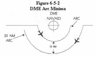
Apply lateral DME separation by requiring aircraft using DME to fly
an arc about a NAVAID at a specified distance using the following minima:
(See Figure 6-5-2)
 |
REFERENCE -
FAAO 7110.65, NAVAID Terms, paragraph 2-5-1.
a. Between different arcs about a NAVAID regardless of direction of flight:
1. At 35 miles or less from the NAVAID - 10 miles.
2. More than 35 miles from the NAVAID - 20 miles.
b. Between an arc about a NAVAID and other airspace to be protected:
(See Figure 6-5-3)
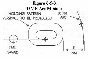 |
NOTE -
The other airspace to be protected may be an MOA, a holding pattern,
airway or route, ATCAA, warning area, restricted area, prohibited area,
etc.
1. At 35 miles or less from the NAVAID - 5 miles.
2. More than 35 miles from the NAVAID - 10 miles.
PHRASEOLOGY -
VIA (number of miles) MILE ARC (direction) OF (name of DME NAVAID).
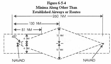
6-5-4 Minima Along Other than Established Airways or Routes
Protect airspace along other than established airways or routes
as follows: (See Figure 6-5-4)
 |
REFERENCE -
P/CG TERM Airway, Route.
a. Direct courses and course changes of 15 degrees or less:
1. Via NAVAIDs or radials FL 600 and below - 4 miles on each side of the route to a point 51 miles from the NAVAID, then increasing in width on a 4 1/2 degree angle to a width of 10 miles on each side of the route at a distance of 130 miles from the NAVAID.
2. Via degree/distance fixes for aircraft authorized under paragraph 4-4-3, Degree - Distance Route Definition for Military Operations.
(a) Below FL 180 - 4 miles on each side of the route.
(b) FL 180 to FL 600 inclusive - 10 miles on each side
of the route.
3. Via degree/distance fixes for RNAV flights above FL 450 - 10 miles
on each side of the route.
NOTE -
Degree/distance RNAV flight (random routes) at FL 450 and below are
provided radar separation.
b. When course change is 16 degrees through 90 degrees, protect the
airspace on the overflown side beginning at the point where the course
changes as follows: (See Figure 6-5-5)
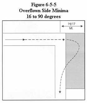 |
1. Below FL 180 - same as subparagraphs a1 or 2.
2. FL 180 to FL 230 inclusive - 14 miles.
3. Above FL 230 to FL 600 inclusive - 17 miles.
c. When course change is 91 degrees through 180 degrees, protect the airspace on the overflown side beginning at the point where the course changes as follows: (See Figure 6-5-6)
1. Below FL 180 - same as paragraph a1 or a2.
2. FL 180 to FL 230 inclusive - 28 miles.
3. Above FL 230 to FL 600 inclusive - 34 miles.
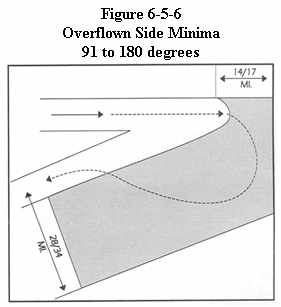 |
d. After the course changes specified in b or c have been completed and the aircraft is back on course, the appropriate minima in a may be used.
REFERENCE -
FAAO 7110.65, Military Operations above FL 600, paragraph 9-3-11.
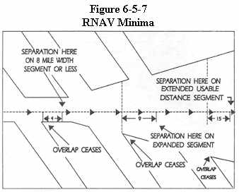
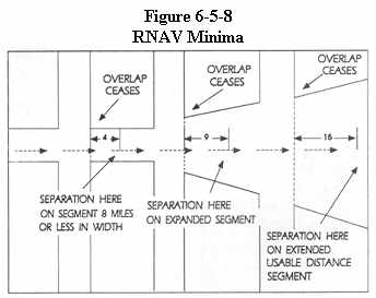
6-5-5 RNAV Minima - Diverging/Crossing Courses
Consider lateral separation to exist when an RNAV aircraft is beyond the point where the lateral protected airspace of that aircraft has ceased to overlap the lateral protected airspace of another by at least: (See Figure 6-5-7 and Figure 6-5-8)
a. When operating along a route that is 8 miles or less in width
- 4 miles.
b. When operating along an expanded route - 9 miles, except that
15 miles shall be applied along that portion of any route segment requiring
extended usable distance limitation beyond 130 miles of the reference facility.
 |
 |