![]()
|
|
||
| CHAPTER 3. Navigation
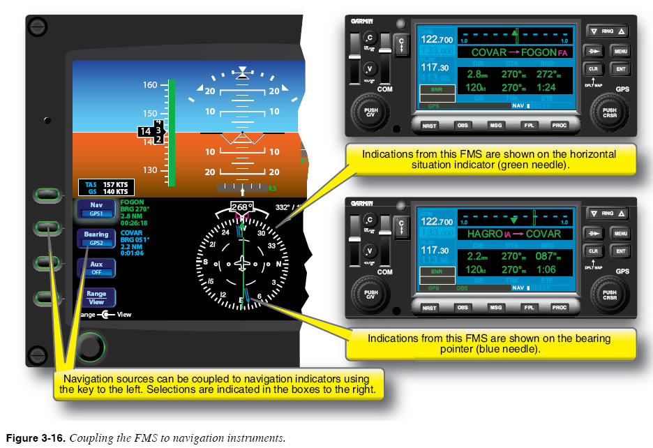
Setting the Course to New Active Waypoint The last step required when arriving at the active waypoint is to set the course to the next waypoint in the planned route. A PFD such as the one shown in Figure 3-16 automatically sets the new course on the navigation indicator when the RNAV computer is engaged in sequencing mode. When an FMS is combined with a traditional course deviation indicator, the pilot must manually set the new course using the OBS knob, unless it is an EHSI, or is slaved. “Slaved” means that there is a servo mechanism in the instrument that will respond to the navigation unit.
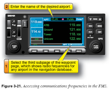
En Route Sensitivity When operating en route, the FMS maintains a sensitivity of 5 nautical miles (NM); that is, a CDI displaying course indications from the FMS deflects full-scale when the aircraft drifts 5 NM to either side of the desired track to the active waypoint. An aircraft is considered to be en route when it is more than 30 NM from the origin and destination airports programmed into the flight plan. There are and have been some units that use different values. Consult your specific unit’s documentation. GPS Signal Status The FMS/RNAV provides position, track, and groundspeed information using signals received from a collection of satellites that are in constant orbit around the Earth when using the GPS navigation source. Although the GPS is highly reliable, satellite reception is sometimes interrupted. Consequently, the pilot must ensure at all times that the system is operational and that it is receiving adequate GPS signals. To simplify this process, all GPS receivers approved for IFR navigation have an automated feature that continually checks the status of the GPS signals. This function is called receiver autonomous integrity monitoring (RAIM). RAIM, which requires adequate simultaneous reception of at least five GPS satellites for IFR navigation reliability, works independently and notifies the pilot when there is a problem with GPS signal reception. When reception problems arise, the FMS/RNAV provides an alert message that notifies the pilot of a GPS reception problem and states that the aircraft position information can no longer be considered reliable. For this reason, regulations require aircraft that are equipped with an RNAV unit using GPS to have an alternate (non-GPS) means of IFR navigation on board (e.g., a VOR receiver) unless the GPS receiver complies with the requirements of WAAS TSO-146B. For all of the previously mentioned reasons, many manufacturers have coupled inertial navigation units with the FMS to deliver unequalled reliability in navigation. Many more complex FMS units also search or scan for distance measuring equipment (DME) signals and VOR signals as additional navigational sources to compute a “blended” position, which is the best calculation from all of the sources and how the FMS is programmed to “consider” the signals for accuracy. GPS RNAV units usually use only GPS signal sources, but may be able to receive VOR and DME signals as well. In the future, many GPS units will probably receive eLORAN as well, since it is a long range navigation system with greatly improved accuracy as compared to the older LORAN-C. One advantage of the LORAN (“e” or “C”) system is that it is ground based and can be easily maintained, as compared to space-based navigation sources. Accessing Navigational Information En Route One of the most useful features of an FMS database is its ability to provide quick access to navigational information. Most units allow the pilot to access information about airports, navigation facilities, airway intersections, and other kinds of waypoints. Figure 3-21 illustrates how one FMS is used to access radio frequencies for an airport.
Essential Skills
|
| ©AvStop Online Magazine Contact Us Return To Books |