![]()
|
|
||
| CHAPTER 3. Navigation
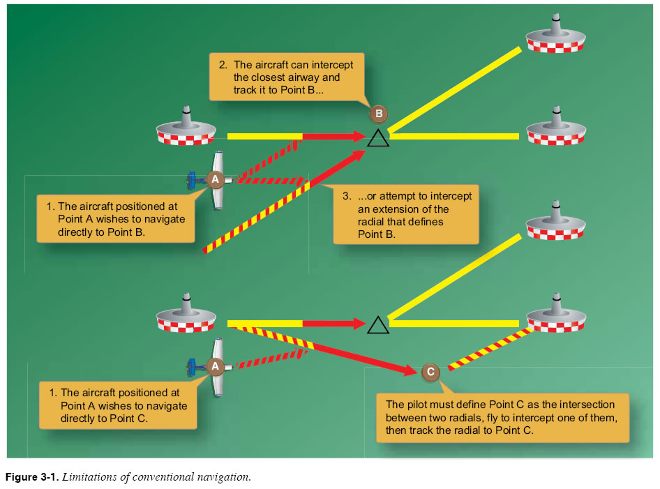
Area Navigation (RNAV) Basics RNAV Concept Area Navigation (RNAV) is a navigation technique that allows pilots to navigate directly between any two points on the globe. Using RNAV, any location on the map can be defined in terms of latitude and longitude and characterized as a waypoint. Onboard RNAV equipment can determine the present position of the aircraft. Using this positional information, the equipment can calculate the bearing and distance to or from any waypoint and permit navigation directly between any two waypoints. In this way, RNAV overcomes a fundamental limitation of conventional navaid point-to-point navigation techniques, which require navigating between electronic navigation transmitters on the ground. The following examples illustrate this limitation. An aircraft equipped with conventional VOR receivers is positioned at Point A as shown in the diagram at the top of Figure 3-1, and the pilot wishes to navigate directly to Point B. Although there appear to be a few VOR stations in the vicinity of the aircraft, it is not clear whether reception is possible from the aircraft’s present position. If the VOR stations are within reception range, the pilot has two choices: (1) fly to intercept the closest airway, then track it to the intersection; or (2) fly to intercept an extension of the radial that defines Point B (assuming reception is possible). Neither alternative provides the pilot with a means of flying directly to the intersection.
Suppose the same aircraft is positioned at Point A as shown at the bottom of Figure 3-1 and the pilot wishes to navigate directly to Point C, which is neither a VOR station nor airway intersection. This pilot has an even more difficult situation. Assuming the VOR stations are within reception range, the pilot needs to create two makeshift airways using a navigation plotter and chart, fly to intercept one of them, then track to Point C (which the pilot has defined as the intersection between the two courses). Flying a direct course to Point C with any degree of accuracy is not possible. Since RNAV systems are not bound by these limitations, the entire airspace is available for navigational use. The national airspace system can thus accommodate more aircraft. However, when the pilot leaves the established airways, he or she also leaves the guaranteed obstruction clearances designed into the airway system. Always plan flights above the maximum elevation figure (MEF) displayed on sectional charts when flying off airways, and be aware that manmade obstructions such as towers may not be added to charts for some time after construction. If flying a new routing, allow for construction, which may not be published yet. FMS/RNAV Computer RNAV is possible through use of a variety of navigation facilities and installed aircraft equipment operated in the U.S. National Airspace System. This handbook focuses on the more common GPS RNAV, a satellite-based radio navigation system available to aircraft equipped with a GPS receiver. In addition to its ability to receive signals from GPS satellites, a GPS receiver also contains a computer processor and a navigation database that includes much of the information found on en route and terminal procedure charts. The newer, more capable units provide map displays, traffic and weather overlays of data, contain VOR/DME/localizer/ glideslope receivers, and can compute fuel usage in addition to the navigation route information. For this reason, the more descriptive term “FMS” is used in this handbook to refer to these GPS receivers. An FMS allows you to enter a series of waypoints and instrument procedures that define a flight route. If these waypoints and procedures are included in the navigation database, the computer calculates the distances and courses between all waypoints in the route. During flight, the FMS provides precise guidance between each pair of waypoints in the route, along with real-time information about aircraft course, groundspeed, distance, estimated time between waypoints, fuel consumed, and fuel/flight time remaining (when equipped with fuel sensor(s)). |
| ©AvStop Online Magazine Contact Us Return To Books |