![]()
|
|
||
| CHAPTER 3. Navigation
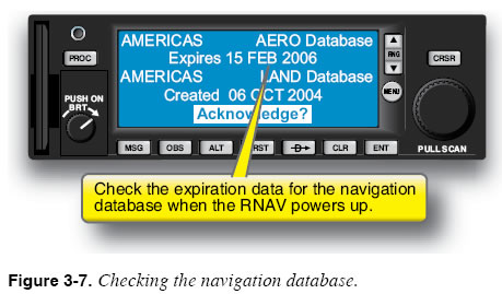
FMS/RNAV Approval for IFR Operations Only some FMS/RNAV units are approved for IFR navigation, and it is important to make this determination before flying with any particular unit. Sometimes, this limitation is based on the installation (i.e., method of installation, qualifications of installer), aircraft approval, availability of approved maintenance, and geographic location. No hand-held GPS unit is approved for IFR navigation, and many panel-mounted units are restricted to VFR use only. Even when an FMS is approved for IFR, the installation of the system in that specific aircraft must also be approved. Even if you have an IFR-approved FMS unit, you may not use it for IFR navigation unless the installation is approved as well. This approval process usually requires a test flight to ensure that there are no interfering inputs, signals or static emanating from the aircraft in flight. RNAV units that do not meet all of these requirements may still be used as situation enhancing navigation resources when operating under instrument flight rules. The first place to check when determining IFR certification for an FMS is the Pilot’s Operating Handbook (POH) or Aircraft Flight Manual (AFM). For every aircraft with an IFR approved FMS/RNAV unit, the AFM explicitly states that the unit has been approved for IFR navigation and what IFR operations are specifically authorized for that installation. Navigation Database Currency The navigation database contained in the FMS must be current if the system is to be used for IFR navigation and approaches. Some units allow en route IFR operations if the navigation waypoints are manually verified by the pilot and accepted. The effective dates for the navigation database are shown on a start-up screen that is displayed as the FMS cycles through its startup self-test. Check these dates to ensure that the navigation database is current. Figure 3-7 shows the start-up screen and effective dates for one popular FMS.
Alternative Means of Navigation To use some GPS-based RNAV units (those certified under Technical Standard Order (TSO) 129) for IFR flight, an aircraft must also be equipped with an approved and alternate means of IFR navigation (e.g., VOR receiver) appropriate to the flight. Ensure that this equipment is onboard and operational, and that all required checks have been performed (e.g., 30-day VOR check). The avionics operations manual/handbook should state the certification status of the installed system. The supplements to the AFM should state the status of the installed equipment, including the installed avionics. Most systems require that the advanced avionics manuals be on board as a limitation of use. NOTAMs Relevant to GPS There are numerous notices to airmen (NOTAMs) that apply specifically to users of navigation aids. For example, when anomalies are observed in the behavior of the global positioning system, or when tests are performed, a GPS UNRELIABLE NOTAM is issued. Similarly, published instrument procedures that rely on RNAV equipment sometimes become “Not Available” when safety concerns arise, such as ground-based interference. It is important to check all NOTAMs prior to IFR flights and, especially, GPS and WAAS NOTAMs before flying. Remember, when talking to a flight service station (FSS)/automated flight service station (AFSS) briefer, you must specifically request GPS/WAAS NOTAMs. GPS Signal Availability GPS-based RNAV equipment that uses the DOD GPS relies on adequate signal reception throughout the course of a flight. Signal reception becomes especially critical during instrument approaches when signal reception criteria become more stringent. Signal reception is generally predictable, and you can request information on likely signal reception for the destination airport in the preflight briefing from Flight Service. Many GPS RNAV units include a feature called receiver autonomous integrity monitoring (RAIM) that allows you to view predictions about future signal reception at specific locations. WAAS-enabled receivers do not have this restriction or limitation due to the error corrections available from the WAAS. WAAS is a form of differential GPS (DGPS) providing enhanced position accuracy. Each Wide Area Reference Station (WRS) provides correction data to a Wide Area Master Station (WMS), which computes a grid of correction data to be uplinked to a geostationary satellite (GEO) from a Ground Earth Station (GES). The geostationary satellite transmits the correction data (and also navigation data) to the user on the L1 GPS navigation frequency (1575.42 MHz). The user GPS receiver uses the downlink WAAS data to correct received navigation data. The goal of WAAS is to obtain at least a 7-meter horizontal and vertical accuracy. Local Area Augmentation System (LAAS), when it becomes available, is another DGPS mode which is designed to provide 1-meter accuracy for precision approaches. It uses a local error VHF transmitter near the runway providing a direct link from the sensor to the aircraft GPS receiver. |
| ©AvStop Online Magazine Contact Us Return To Books |