![]()
|
|
||
| CHAPTER 3. Navigation
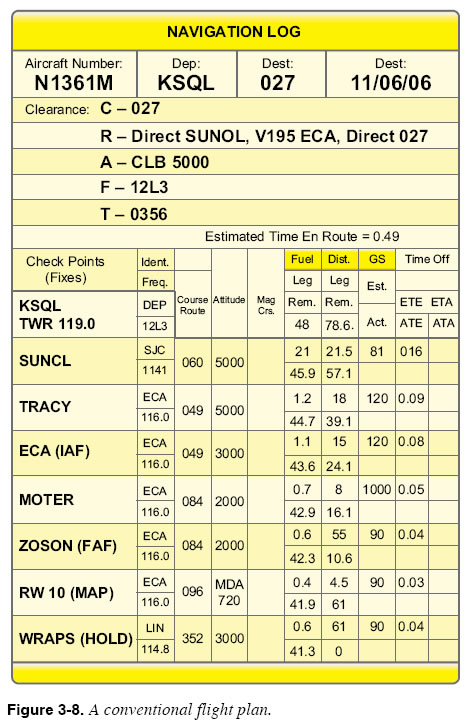
Alternate Airports It is very important to know what equipment is installed in the aircraft. GPS-based FMS/RNAV units certified to TSO-C145A or TSO-146A may be used when an alternate airport is required in the flight plan for the approaches at the destination and alternate airport if the WAAS is operational. No other navigation avionics would be required. Units certified under TSO-C129 are not authorized for alternate approach requirements. The aircraft must have stand-alone navigation equipment, such as VOR, and there must be an approved instrument approach at the alternate airport based on that equipment. (However, once diverted to the alternate airport, the pilot could fly a GPS-based approach there, as long as there is an operational, ground-based navaid and airborne receiver in the aircraft for use as a backup.) Aircraft Equipment Suffixes Since air traffic control (ATC) issues clearances based on aircraft equipment suffixes, consult the Aeronautical Information Manual (AIM) Table 5-1-2, Aircraft Suffixes, to ensure that the flight plan includes the correct equipment suffix for a particular aircraft. Use the suffix that corresponds to the services and/or routing that is needed. For example, if the desired route or procedure requires GPS, file the suffix as “/G” or “/L,” as appropriate to that aircraft, and operational equipment installed. (Remember that minimum equipment list (MEL) deferred items can change the status of the aircraft.) Suitability of an RNAV Unit for VFR Flight Even when an RNAV receiver is to be used only for supplemental (“supplemental” meaning a situation enhancing source of navigation information, but not the primary or sole source of navigation information) navigation information during VFR flight, you should consider these suitability factors in the interest of safety. The use of an expired navigation database might cause you to stray into airspace that was not yet designated at the time the expired navigation database was published. Some VFR-only GPS units do not alert you when signal reception has faded, which could lead to reliance on erroneous position information. Lack of attention to the “see and avoid” basic principle of every visual meteorological conditions (VMC) flight means too much time spent focused inside the cockpit on advanced avionics versus staying synchronized with the flight events, possibly creating a life-threatening total flight situation. Programming the Flight Route The procedures used to program an FMS with your intended route of flight are fundamentally the same in all types of systems, yet many differences are evident. The primary difference between systems lies mainly in the “knob or switchology”—the specific design features, operational requirements, and layout of the controls and displays used to operate the avionics. Be thoroughly familiar with the procedures required for each FMS or RNAV unit to be used. Suppose you have planned a flight from San Carlos Airport (KSQL) to Oakdale Airport (O27), as shown in the flight plan appearing in Figure 3-8. The planned route proceeds directly to SUNOL intersection, then follows V195 until reaching ECA, the initial approach fix for the GPS Runway 10 approach into Oakdale. The distances, bearings, estimated times en route, and fuel requirements for the flight have all been calculated. The next step is to enter some of these details into the FMS.
|
| ©AvStop Online Magazine Contact Us Return To Books |