![]()
|
|
||
| CHAPTER 5. Information Systems
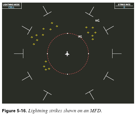
Lightning Most MFDs are also capable of depicting electrical activity that is indicative of lightning. Like radar data, lightning data can come from two sources: onboard and broadcast weather systems. Both systems have strengths and limitations and work together to present a more complete weather picture. Lightning data is an excellent complement to radar data for detecting the presence of thunderstorms. An onboard lightning detection system consists of a simple antenna and processing unit that senses electrical discharges in the atmosphere and attempts to determine which electromagnetic signals have the “signature” of lightning strikes. Lightning detectors or spherics receivers, such as Stormscope® and Strikefinder ®, have been known to indicate areas of static consistent with turbulence even where there was no rain associated with the turbulence. The MFD in Figure 5-16 depicts lightning strikes detected by a lightning detection system. Onboard lightning detection systems provide real-time information about electrical discharges. Estimates of the direction (or azimuth) of electrical discharges provided by an onboard lightning system are usually quite accurate. Estimates of the range (or distance) of electrical discharges tend to be less accurate.
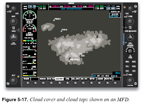
Broadcast (or data link) weather services are also capable of transmitting lightning data to the cockpit. The symbology used to present lightning data derived from these sources is similar to that used by onboard lightning detection systems. The lightning data provided by ground weather surveillance systems is also a delayed weather product. Since the lightning data provided by a broadcast service is derived from multiple sensors, estimates of the range of electrical discharges are more accurate than those provided by onboard systems. Clouds Weather products that describe cloud coverage are generally available only from broadcast weather services. One popular broadcast weather service offers graphical displays of visible cloud cover along with the cloud top altitude as determined from satellite imagery. Figure 5-17 shows an MFD that depicts cloud cover and cloud tops.
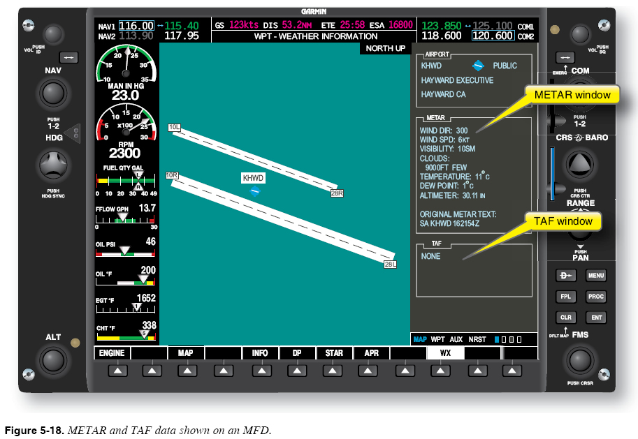
Other Weather Products Broadcast weather services offer many of the other weather products that can be obtained during a pre-flight briefing on the ground. Broadcast weather services can also provide graphical wind data, SIGMETs and AIRMETs, freezing levels, temporary flight restrictions, surface analyses, and hurricane tracks. The MFD in Figure 5-18 shows METAR and TAF data.
Using Advanced Weather Data Systems The increased availability of weather information is changing the way pilots think about weather briefing and the weather decision-making process. You are no longer limited to obtaining weather forecast products prior to a flight, only to discover different actual flight conditions in the air. Now more than ever, weather briefing is an activity that begins prior to departure and continues until the flight is completed. |
| ©AvStop Online Magazine Contact Us Return To Books |