![]()
|
|
||
| CHAPTER 5. Information Systems
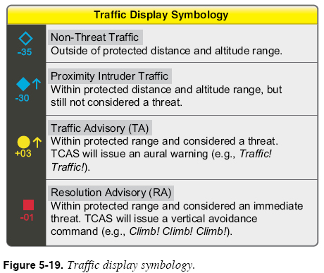
Common Error: Skipping the Preflight Weather Briefing The easy availability of weather information in the cockpit can lure you to skip the preflight weather briefing. Time pressure adds further incentive to simply jump in and go. Keep in mind that flight services stations (FSS)/automated flight service stations (AFSS) offer many advantages over an advanced weather data system, so do not use advanced avionics weather data systems as a substitute for a pre-flight weather briefing. As a simple example, when talking to an FSS/AFSS weather briefer, it is possible to get a better overall picture of the weather system and pilot reports not yet entered into the system. The FSS/AFSS briefer can also supply more Notice to Airmen (NOTAM) and other detailed information for your particular route of flight; without such briefing, the pilot might expend many precious moments searching for a critical bit of information, instead of managing the flight. Often, it is much easier to get a thorough briefing on the ground than attempting to read small reports on a bouncing MFD in a small airplane in turbulent conditions. Traffic Data Systems A traffic data system is designed to help you visually acquire and remain aware of nearby aircraft that pose potential collision threats. All traffic data systems provide aural alerts when the aircraft comes within a certain distance of any other detected aircraft. Traffic data systems coupled with MFDs can provide visual representations of surrounding traffic. Most traffic data systems allow you to set the sensitivity of the system and display only traffic that exists within a specific distance from the aircraft. There are two basic types of traffic data systems available today: one using onboard sensors to detect nearby aircraft, the other relying on traffic information transmitted from ground facilities to the cockpit. Traffic Data Systems Using Onboard Sensing Equipment Traffic collision avoidance systems (TCAS) and traffic advisory (TA) systems use onboard sensing equipment to locate nearby aircraft and provide alerts and advisories. Both TCAS and TA systems work by querying the transponders of nearby aircraft to determine their distance, bearing, altitude, and movement relative to your aircraft. In addition, TCAS and TA systems use Mode C information from transponders to determine altitude and vertical movement of surrounding aircraft. Using these capabilities, TCAS and TA systems provide traffic alerts and advisories. TCAS I and TA systems can issue a TA whenever another active transponder-equipped aircraft comes within an approximately 40-second range of the aircraft. Traffic advisories take the form of an aural alert: “Traffic! Traffic!” Advanced TCAS systems (TCAS II) can also issue a resolution advisory (RA) when another active transponderequipped aircraft comes within an approximately 25-second range of the aircraft. RAs take the form of an avoidance command that instructs you how to fly the aircraft in order to avoid the threat. An aural alert is issued that instructs the pilot to perform a vertical avoidance maneuver. Example aural alerts are: “Climb! Climb!” and “Descend! Descend!” TCAS and traffic advisory systems use similar symbology to present traffic information. Figure 5-19 shows four common traffic symbols used on traffic displays. The resolution advisory symbols appear only when an advanced TCAS II system is used. The colors used to display traffic symbols vary with the capabilities of the display.
Despite their many advantages, TCAS and traffic advisory systems have several important limitations. For example, TCAS and traffic advisory systems cannot detect aircraft that do not have active transponders. Another limitation of TCAS and traffic advisory systems is that they give unwanted alerts when the pilot is purposefully operating in the vicinity of other aircraft. For example, two aircraft making approaches to parallel runways will probably receive traffic alerts. These alerts can be distracting. Traffic Data Systems Receiving Information From Ground-based Facilities The traffic information service (TIS) is a second type of traffic data system. Unlike TCAS, the TIS system does not require each aircraft to have an onboard sensor that locates nearby aircraft. However, each aircraft must have operational and active transponders to be indicated on the ATC system. Rather, TIS captures traffic information that appears on radar scopes at nearby air traffic control facilities and broadcasts that information to appropriately equipped aircraft. In order to use TIS, aircraft must be equipped with a transponder capable of receiving TIS broadcasts. When TIS is operational, b-capable aircraft can observe traffic information in the cockpit and receive traffic advisories for proximate aircraft. There is an important limitation of TIS. TIS data is only transmitted from approach radar facilities. No information is broadcast from en route (air route traffic control center (ARTCC)) facilities, so the effective coverage of TIS is limited to larger metropolitan areas. Some approach radar facilities are not equipped to send TIS information. Note that the aircraft must be within range (approximately 50 NM) and within line of site of the TIS station to receive broadcasts. |
| ©AvStop Online Magazine Contact Us Return To Books |