![]()
|
|
||
| CHAPTER 4. Automated Flight Control
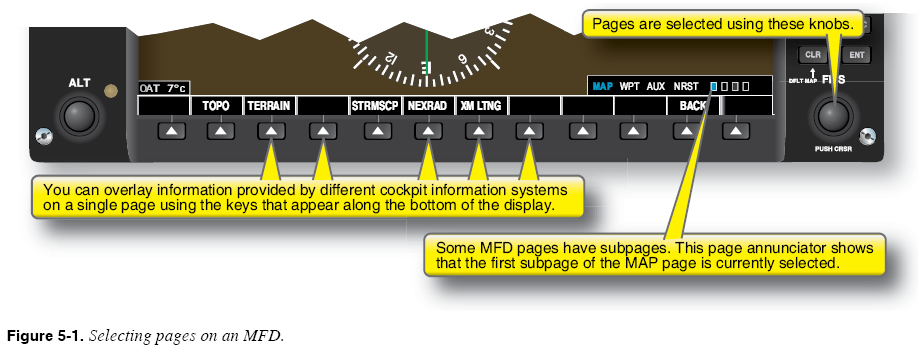
Multi-Function Display A multi-function display (MFD) presents information drawn from a variety of aircraft information systems. Many installations allow overlay or inclusion of systems indications in the primary flight display (PFD), in addition to the primary flight instrument indications. By allowing you to view information provided by any one or combination of the installed systems, the MFD prevents the need for a separate display for each system. As does the flight management system (FMS)/area navigation (RNAV) unit, the MFD allows you to select different pages from different chapters that display information provided by various aircraft systems. Other controls allow you to combine information from multiple systems on one page. In many installations, the MFD serves as the backup or faildown display for the PFD. You should have a working knowledge of the faildown selection procedures and how to select the necessary data displays for the current flight phase. The controls provided by one MFD are shown in Figure 5-1.
Invest the time required to become a skilled user of the MFD. Familiarity with the capabilities of the MFD not only increases the information available, but also allows quick access to that information for safe flight decision-making. Essential Skills
Moving Maps The moving map function uses the MFD to provide a pictorial view of the present position of the aircraft, the route programmed into the FMS, the surrounding airspace, and geographical features. Moving maps offer a number of options that allow you to specify what information is presented on the MFD and how it is displayed. Moving maps typically offer several different map orientations (e.g., north up, track up), a range control that allows you to “zoom” in and out to see different volumes of airspace, and a means to adjust the amount of detail shown on the display (declutter). The moving map display does not replace looking outside the aircraft to avoid other aircraft and obstructions. Using the Moving Map A moving map display has a variety of uses that can aid your awareness of position and surroundings during almost any phase of flight. Verification of the displayed data with a chart accomplishes three functions:
|
| ©AvStop Online Magazine Contact Us Return To Books |