![]()
|
|
||
| CHAPTER 5. Information Systems
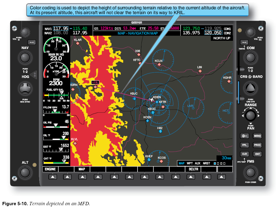
Terrain Display The most basic type (not necessarily certified) of terrain system is the terrain display. A terrain display uses the MFD to plot the position of the aircraft against a pictorial presentation of surrounding terrain. A terrain display usually relies on a GPS location signal to compare the position and altitude of the aircraft against the terrain found in an internal topographical database. Figure 5-10 shows the position of the aircraft and surrounding terrain displayed on an MFD.
Terrain displays use a simple color-coding convention to portray the difference between the present altitude of the aircraft and the height of the surrounding terrain. Terrain more than 1,000 feet below the aircraft is coded black. Terrain less than 1,000 feet but more than 100 feet below the aircraft is coded yellow. Terrain less than 100 feet below the aircraft is coded red. Man-made obstacles (e.g., radio towers, power lines, buildings) generally do not appear in a topographical database. Monitoring Surrounding Terrain During Departure and Arrival Terrain displays are especially useful during departure and arrival phases of flight. For example, the aircraft shown in Figure 5-10 has departed Denver and is heading for a waypoint situated in high terrain in the Rocky Mountains. A pilot with good situational awareness has many concerns during the departure. For instance, is climb performance meeting expectations? The terrain display reduces the need for you to perform mental calculations by verifying that the depiction of the terrain that lies ahead of the aircraft is steadily changing from red to yellow to black. If the terrain depiction remains red as the aircraft approaches, you know there is a problem. Similarly, if the aircraft has been assigned a heading and altitude vector by air traffic control, the terrain display provides a simple way of monitoring the safety of these directives. If the equipment is not certified as meeting TAWS requirements (see Title 14 of the Code of Federal Regulations (14 CFR) part 91, section 91.223), the accuracy can be in doubt. |
| ©AvStop Online Magazine Contact Us Return To Books |