![]()
|
|
||
| CHAPTER 5. Information Systems
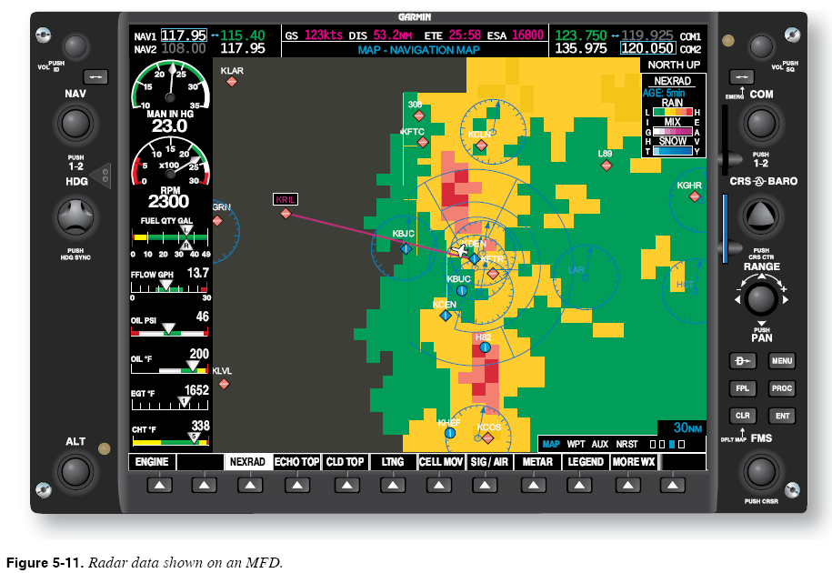
Risk: Flying in Close Proximity to Terrain A display that plainly shows your position with respect to surrounding terrain is sometimes cited as the most reassuring system available in the advanced avionics cockpit. The same display can also invite the unwary pilot to attempt risky maneuvers. Suppose that, on a VFR flight to an airport located in hilly terrain, you encounter a layer of fog at 1,100 feet. In an aircraft with no terrain system, you would not consider proceeding to the airport because you have a personal minimum of 1,500 feet. With a ceiling of less than 1,500 feet, you deem the situation simply too risky. With the surrounding terrain neatly displayed in front of you, however, you may feel more confident and be tempted to give it a try. However, a wise pilot remembers that, unless the equipment is TAWS certified, accuracy is suspect. Even with TAWS certification, the information presented is no better than the database accuracy. Consult the equipment handbook or manual to determine the accuracy of the database in that area. CFIT accidents are still occurring despite the advent of advanced avionics. What has happened here? Psychologist Gerald J. S. Wilde coined the phrase risk homeostasis to refer to a tendency for humans to seek target levels of risk. Our hill-flying scenario illustrates the concept. After pondering the perceived risks, you decide that having the terrain display gives you the same level of perceived risk with a 1,000-foot ceiling as you felt you had at 1,500 feet without the terrain display. You see no need to “give away” this new margin of perceived safety. Rather, you decide to use it to your advantage. Equipped with the terrain display, your new minimum ceiling becomes 1,000 feet, and you continue on your way to the airport. Wilde does not support the idea of using technology to seek target levels of risk. Rather, he argues that safety measures such as seat belt laws and anti-lock brakes have not resulted in drastic reductions in highway fatalities in part because, in response to the added sense of safety provided by these measures, drivers have emboldened their driving behavior to maintain existing levels of risk. Another issue is the lack of training in the new equipment and its uses. The functions of TAWS and basically how it works have been previously described, yet there is no training program outside the military that teaches anyone to fly based on the TAWS display. It requires much precision flight training to learn the timing and skills to fly from a display depicting a myriad of data and converting that data into close and low terrain flight directions. All advanced avionics are designed to help the pilot avoid a hazard, not enable the pilot to get closer to it. TAWS is not a terrain flight following system. Cockpit Weather Systems Advanced avionics cockpit weather systems provide many of the same weather products available on the ground and have a variety of uses that can enhance awareness of weather that may be encountered during almost any phase of flight. Radar images, satellite weather pictures, Aviation Routine Weather Reports (METARs), terminal weather forecasts (TAFs), significant meteorological information (SIGMETs), Airmen’s Meteorological Information (AIRMETs), and other products are now readily accessible at any time during flight. Weather products provided by cockpit weather systems are typically presented on an MFD. Some installations allow the overlay of this data in the PFD. You must learn the procedures required to show each kind of weather product on the MFD and/or PFD, and how to interpret each type of weather product. Know the limitations of each type of product, and the ways in which cockpit weather systems can be used to gather information and remain clear of weather hazards throughout the flight. Thunderstorms and Precipitation Thunderstorms and general areas of precipitation are detected through the use of radar. In the advanced avionics cockpit, radar data can come from one of two sources: an onboard weather radar system or a ground weather surveillance radar system, such as the Next Generation Radar (NEXRAD) system. Ground weather surveillance system data is transmitted to the cockpit via a broadcast (or datalink) weather service. Onboard weather radar and ground weather surveillance radar systems each offer advantages and disadvantages to the pilot. Some aircraft use a combination of both systems. While onboard radar is real time, many downloaded radar images and other reports are delayed for some time period for various reasons. Given the nature of thunderstorms and other weather hazards, this delay could prove hazardous. You must know the true quality and age of the data. Most MFDs are capable of presenting radar data together with aircraft position and the programmed route, as shown in Figure 5-11.
|
| ©AvStop Online Magazine Contact Us Return To Books |