Whether a pilot becomes confused depends on whether or not a definite plan is followed. The greatest hazard to a pilot failing to arrive at a given checkpoint at a particular time, is panic. The natural reaction is to fly to where it is assumed the checkpoint is located. On arriving at that point and not finding the checkpoint, a second position is usually assumed, and the panicked pilot will then fly in another direction for some time. As a result of several of these wanderings, the pilot may have no idea where the plane is located. Generally if planning was correct and the pilot uses basic dead reckoning until the estimated time of arrival (ETA) runs out, the airplane is going to be within a reasonable distance of the planned checkpoint.
There are several different actions to be followed when the pilot is unsure of the airplane's position while using pilotage or dead reckoning. The best choice depends upon the circumstances, but usually they should be applied in the following sequence.
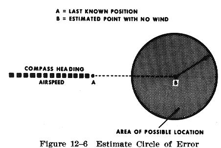
When unsure of one's position, the pilot should continue to fly the original heading and watch for recognizable landmarks, while rechecking the calculated position. By plotting the estimated distance and compass direction flown from the last noted checkpoint as though there were no wind, the point so determined will be the center of a circle within which the airplane's position may be located (Fig. 12-6). This is often called a "circle of error." If it is certain that the wind is no more than 30 knots, and it has been 30 minutes since the last known checkpoint was noted, the radius of the circle should be about 15 nautical miles. It is then a matter of continuing straight ahead, and checking landmarks within this circle. The most likely position will be downwind from the desired course.
If this procedure fails to identify the position, the pilot should change course toward the nearest concentration of prominent landmarks shown on the chart. If some town or developed area is sighted, the pilot can circle low to observe identifiable features or markings; but the pilot should comply with the minimum safe altitudes prescribed in FAR Part 91.
In the event these methods are ineffective in locating position, or when fuel exhaustion or darkness is imminent, it is recommended that the pilot make a precautionary landing while adequate fuel and daylight are still available. It is desirable, of course to land at an airport, but if one cannot be found, a suitable field may be used. Prior to landing at other than an established airport, the pilot should first survey the area for obstructions or other hazards.
When a landmark is finally recognized, or a probable fix
obtained, the pilot should at first use the information both cautiously
and profitably. If there is a pronounced discrepancy, it is well to be
dubious of the new fix until it can be positively identified. NO ABRUPT
CHANGE in course should be made until a second or third landmark is found
to corroborate the first.
It is well to determine the probable cause of getting
off the course originally so that the error will not be repeated. Miscalculations
in determining the ground track may arise from miscalculating the wind
drift, applying the wind forecast at a level at which drift is opposite
to that at cruising altitude, applying magnetic variation to the compass
incorrectly, or simply from misreading the compass.
When the airplane seems to have made an abnormally high or low groundspeed, the error may be caused by using the wrong mileage scale (nautical versus statute), misreading the clock, skipping mileage marks when scaling the course line on the chart, using improper airspeed indications (knots versus MPH), or from other causes. Whatever the error, once determined it should be borne in mind to avoid repetition on the remainder of the flight. In some cases it may be necessary to reestimate the fuel hours remaining and to change the destination accordingly.
DF (VHF/UHF Direction Finder) equipment is of particular value in locating lost aircraft and in giving guidance to the pilot. DF is a ground based radio receiver with an azimuth display used by the operator of the ground stations where it is located, usually at FSSs and control towers. The pilot needs only two way VHF radio communications capability to make use of the services available.
The ground equipment consists of a directional antenna
system, an azimuth display screen, and a VHF (and UHF) radio receiver.
At a radar equipped tower or center, the cathode ray tube indications may
be superimposed on the radarscope.
The DF display indicates the magnetic direction of the
airplane from the station each time the pilot transmits. Where DF equipment
is tied into radar, a strobe of light is flashed from the center of the
radarscope in the direction of the airplane.
Regardless of the equipment used, all operate on the principle of indicating the bearing from the station to the airplane or from the airplane to the station. It is necessary for the pilot to be transmitting in order for the DF operator to take a bearing. Once this bearing has been established, it is relatively easy for the operator to direct the pilot to the desired point.
When a pilot is in doubt about the airplane's position, or feels apprehensive for the safety of the flight, there should be no hesitation to request assistance from the nearest FSS. Search facilities, including radar, radio, and DF stations, are ready and willing to help, and there is no penalty for using them. Delay in asking for help has often caused accidents and cost lives. Safety is not a luxury that is beyond the pilot's means.