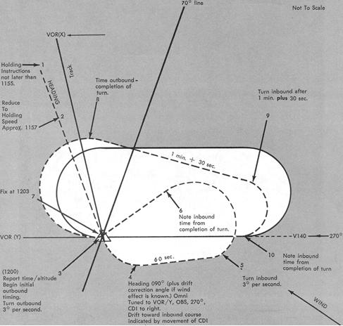
Entry Time reported to ATC (see "Additional Reports" in this chapter)
is the initial time of arrival over the fix.
Initial Outbound Leg is flown for 1 minute at or below 14,000
feet MSL and for 1 1/2 minutes above 14,000 feet MSL. Timing for subsequent
outbound legs should be adjusted as necessary to achieve proper inbound
leg time.
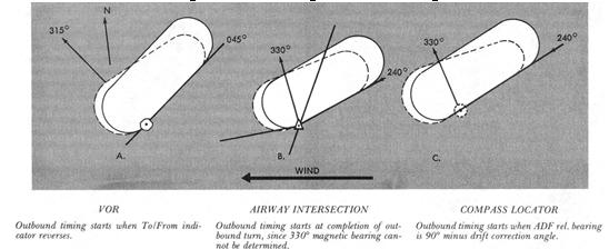
Outbound Timing begins OVER OR ABEAM the fix, whichever occurs
later. If the abeam position cannot be determined, start timing when turn
to outbound is completed (Fig. 12-7).
Figure 12-7. Holding - outbound timing.
|
No other time adjustments are necessary unless ATC specifies a time to leave the holding fix, as on a timed approach (see Fig. 12-4). Any necessary reduction in holding time will depend upon the time required to complete a circuit of the pattern. If, for example, a complete circuit requires 4 1/2 minutes, and the fix departure time is 12 minutes after passage over the fix, fly two more patterns (9 minutes) and shorten the outbound leg on the last circuit to provide for a total of 1 minute except for the turns, which at 3° per second will take 2 minutes. Precise timing requires rapid cross-check and planning, in addition to the attention devoted to basic attitude control, tracking, and ATC communications.
Expect Approach Clearance Times (EAC) and Expect Further Clearance Times (EFC) require no time adjustment since the purpose for issuance of these times is to provide for possible loss of two-way radio communications. You will normally receive further clearance prior to your EAC or EFC. If you fail to receive it, request it.
Time Leaving the holding fix must be known to ATC before succeeding aircraft can be cleared to the airspace you have vacated (see "Additional Reports" in this chapter). Leave the holding fix -
1. When ATC issues either further clearance enroute or approach
clearance.
2. As prescribed in FAR 91 (for IFR operations; two-way radio
communications failure and responsibility and authority of the pilot in
command) or
3. After you have canceled your IFR flight plan, if you are
holding in VFR conditions.
The diagram in Figure 12-8 shows the application of the foregoing
procedures. Assume approach to the holding fix on the following ATC clearance,
estimating Fox 1200:
FASTFLIGHT FIVE FOUR THREE TWO KILO - HOLD EAST OF FOX
INTERSECTION ON VICTOR ONE FOUR ZERO - MAINTAIN SEVEN THOUSAND
- EXPECT FURTHER CLEARANCE AT ONE TWO TWO ZERO.
Steps 1-10 show you overheading the fix inbound at 1203, with 17 minutes remaining to hold. If the first complete holding circuit takes 4 minutes, 30 seconds, you should therefore expect further clearance (1220) on the fourth circuit approximately 1 minute from the fix, inbound.
DME Holding. The same entry and holding procedures apply to DME
holding except distances (nautical miles) are used instead of time values.
The outbound course of the DME holding pattern is called the outbound leg
of the pattern. The length of the outbound leg will be specified by the
controller and the end of this leg is determined by the DME odometer reading.
Approaches
Instrument Approaches to Civil Airports. Unless otherwise authorized,
each person operating an aircraft shall, when an instrument letdown to
an airport is necessary, use a standard instrument approach procedure prescribed
for that airport. Instrument approach procedures are depicted on National
Ocean Survey Instrument Approach Procedure Charts.
ATC approach procedures depend upon the facilities available
at the terminal area, the type of instrument approach executed, and the
existing weather conditions. The ATC facilities, navigation aids, and associated
frequencies appropriate to each standard instrument approach are given
on the approach chart. Individual charts are published for standard approach
procedures associated with the following types of facilities:
1. Nondirectional beacon (NDB).
2. Very high frequency omnirange (VOR).
Figure 12-8. Holding at an intersection.
 |
3. Very high frequency omnirange with distance measuring equipment
(VORTAC or VOR/DME).
4. Instrument landing system (ILS).
5. Localizer type directional aid (LDA).
6. Simplified directional facility (SDF).
Charts are also published for Area Navigation (RNAV) approaches (see Figure 7-21).
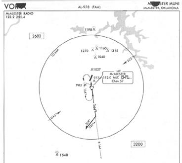
Approach to an Airport with Airport Advisory Service but No Tower. Figure 12-9 shows the approach procedure at an airport where a Flight Service Station is located. When direct communication between the pilot and controller is no longer required, the ARTCC controller will clear you for an instrument approach and advise you to contact the FSS for airport advisory information. During the approach you will have the benefit of information concerning current weather, known traffic, and any other conditions affecting your flight.
If you are arriving on a "cruise" clearance, ATC will not issue further clearance for approach and landing. The term "cruise" authorizes you to fly at any altitude from the minimum IFR altitude up to and including the altitude specified in the clearance. You may level off at any intermediate altitude within this block of airspace. A climb or descent within the block may be made at your discretion; however, once you start to descend and report leaving an altitude in the block, you may not return to that altitude without an additional clearance. Also, a "cruise" clearance authorizes you to proceed to and make an approach at your destination airport. You are required to comply with communications and reporting procedures as on any IFR clearance.
Figure 12-9. Instrument approach procedure chart - no tower but advisory service available.
 |
 |
If an approach clearance is required, ARTCC will authorize you to execute your choice of standard instrument approaches (if more than one is published for the airport) with the phrase "CLEARED FOR APPROACH" and the communications frequency change required, if any. Inbound from the procedure turn, you will have no contact with ATC. Accordingly, you must close your IFR flight plan before landing, if in VFR conditions, or by telephone after landing.
Unless otherwise authorized by ATC, you are expected to execute the complete instrument approach procedure shown on the chart.
Approach to an Airport with Tower and Approach Control but No Radar. Where the approach chart for your destination airport indicates approach control without radar (the notation ASR or RADAR VECTORING will be absent), ARTCC will clear you to an approach/outer fix with the appropriate information and instructions:
1. Name of the fix.
2. Altitude to be maintained.
3. Holding information and expected approach clearance time,
if appropriate.
4. Instructions regarding further communications, including:
a. facility to be contacted.
b. time and place of contact.
c. frequency/ies to be used.
If the tower has ATIS, you should monitor that frequency for such
information as ceiling, visibility, wind direction and velocity, altimeter
setting, instrument approach and runways in use prior to initial radio
contact with approach control. The ATIS frequency is listed on the approach
chart, enroute chart, and in the AIRMAN'S INFORMATION MANUAL. If there
is no ATIS, approach control will, at the time of your first radio contact
or shortly thereafter, give you the above information.
Approach to an Airport with Tower, Approach Control, and Radar.
Where radar is approved for approach control service, it is used not only
for radar approaches (ASR and PAR) but is also used to provide vectors
in conjunction with published instrument approach procedures predicated
on radio navaids such as ILS, VOR, and NDB. Radar vectors can provide course
guidance and expedite traffic to the final approach course of any established
instrument approach procedure.
Approach control facilities that provide this radar service operate in the following manner:
1. Arriving aircraft are either cleared to an outer fix most
appropriate to the route being flown with vertical separation and, if required,
given holding information; or,
2. When radar hand-offs are effected between ARTCC and approach
control, or between two approach control facilities, aircraft are cleared
to the airport, or to a fix so located that the hand-off will be completed
prior to the time the aircraft reaches the fix.
a. When the radar handoffs are utilized, successive arriving
flights may be handed-off to approach control with radar separation in
lieu of vertical separation.
b. After hand-off to approach control, aircraft are vectored
to the appropriate final approach course; e.g., ILS, ADF or NDB.
3. Radar vectors and altitude/flight levels will be issued as
required for spacing and separating aircraft; THEREFORE, YOU MUST NOT DEVIATE
FROM THE HEADINGS ISSUED BY APPROACH CONTROL.
4. You will normally be informed when it becomes necessary to vector you across the final approach course for spacing or other reasons. If you determine that approach course crossing is imminent and you have not been informed that you will be vectored across it, you should question the controller. You should not turn inbound on the final approach course unless you have received an approach clearance. Approach control will normally issue this clearance with the final vector for interception of the final approach course, and the vector will be such as to enable you to establish your aircraft on the final approach course prior to reaching the final approach fix. In the event you are already inbound on the final approach course, you will be issued approach clearance prior to reaching the final approach fix.
5. After you are established inbound on the final approach course, radar separation will be maintained between you and other aircraft and you will be expected to complete the approach using the navaid designated in the clearance (ILS, VOR, NDB, etc.) as the primary means of navigation. Therefore, once you are established on the final approach course, you must not deviate from it unless a clearance to do so has been received from air traffic control.
6. After passing the final approach fix inbound, you are expected to proceed direct to the airport and complete the approach, or to execute the published missed approach procedure.
7. Radar service is automatically terminated when the landing is completed or the tower controller has your aircraft in sight, whichever occurs first.
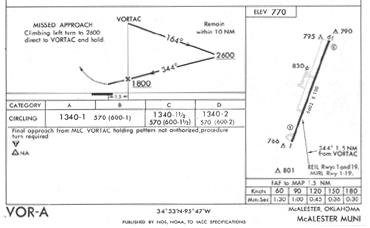
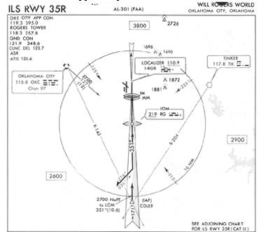
Figure 12-10 is a reproduction of an instrument approach procedure
chart with maximum ATC facilities available.
Radar Approaches. Initial radar contact for either a surveillance
or precision radar approach is made with approach control. You must comply
promptly with all instructions when conducting either type procedure. You
can determine the radar approach facilities (Surveillance and/or Precision)
available at a specific airport by referring to the appropriate Enroute
Low Altitude Chart and Instrument Approach Procedure Chart. Surveillance
(ASR) and precision (PAR) radar minimums (Fig. 12-11) are listed alphabetically
by airport on pages titled, "CIVIL RADAR INSTRUMENT APPROACH MINIMUMS,"
in the first part of each Instrument Approach Chart booklet. You will note
that both straight-in and circling minimums are listed.
Figure 12-10. Instrument approach procedure chart - maximum ATC facilities.
 |
 |
Surveillance Approach. On a surveillance radar approach, the controller will vector you to a point where you can begin a descent to the airport/heliport or to a specific runway. During the initial part of the approach you will be given communications failure/missed approach instructions. Before you begin your descent, the controller will give you the published straight-in MDA. You will not be given the circling MDA unless you request it and tell the controller your aircraft category.
During the final approach, the controller will provide navigational guidance in azimuth only. Guidance in elevation is not possible but you will be advised when to begin descent to the minimum descent altitude (MDA) or if appropriate, to the intermediate "step down fix" minimum crossing altitude and subsequently to the prescribed MDA. In addition, you will be advised of the location of the missed approach point (MAP) and your position each mile from the runway, airport/heliport, or MAP as appropriate. If you so request, the controller will issue recommended altitudes each mile, based on the descent gradient established for the procedure, down to the last mile that is at or above the MDA. You will normally be provided navigational guidance until you reach the MAP. The controller will terminate guidance and instruct you to execute a missed approach at the MAP, if at that point you do not have the runway or airport/heliport in sight, or if you are on a point-in-space approach in a helicopter, the prescribed visual reference with the surface is not established. Any time during the approach the controller considers that safe guidance for the remainder of the approach cannot be provided, the approach will be terminated and you will be instructed to execute a missed approach. Also, guidance termination and missed approach will be effected upon pilot request and, for civil aircraft only, the controller may terminate guidance when the pilot reports the runway, airport/heliport, or visual surface route (point-in-space approach) in sight or otherwise indicates that continued guidance is not required. Radar service is automatically terminated at the completion of the radar approach.
Precision Approach. Duluth International (Fig. 12-11 is one of the few airports that still has PAR. The installations that do have PAR are joint civil/military airports and usually provide service to civilian pilots flying IFR only {with} prior permission, except in an emergency.
A PAR serves the same purpose as an Instrument Landing System (ILS) except guidance information is presented to the pilot through aural rather than visual means. If a PAR is available, it is normally aligned with an ILS. During a PAR approach, you are provided highly accurate guidance in both azimuth and elevation.
The precision approach begins when the aircraft is within range of the precision radar and contact has been established with the PAR controller. Normally this occurs approximately eight miles from touchdown, a point to which you are vectored by surveillance radar or are positioned by a non-radar approach procedure. You will be given headings to fly, to direct you to, and to keep your aircraft aligned with the extended centerline of the landing runway.
Prior to intercepting the glide path, you will be advised of communications failure/missed approach procedures and told not to acknowledge further transmissions. You will be told to anticipate glide path interception approximately 15 to 30 seconds before it occurs, and when to start your descent. The published decision height (DH) will be given only if you request it.
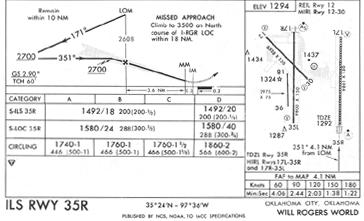
Figure 12-11. Radar minimums.
DULUTH INTL MN Amdt. 11, SEP 29, 1976
ELEV 1429 DH/ HAT/ DH/ HAT/
RWY CAT MDA-VIS HAA CEIL-VIS CAT MDA-VIS HAA CEIL-VIS
PAR 9 ABCDE 1627/24 200 (200-1/2)
ASR 27 ABC 1820/24 399 (400-1/2) DE 1820/50 399 (400-1)
9 ABC 1840/24 413 (500-1/2) DE 1840/50 413 (500-1)
CIRCLING AB 1880-1 451 (500-1) C 1880-1 1/2 451 (500-1 1/2)
D 1980-2 551 (600-2) E 2360-2 931 (1000-2)
During the final approach, the controller will give elevation information as, "slightly/well above" or " slightly/well below" glide path and course information as "slightly/well right" or "slightly/well left" of course. Extreme accuracy in maintaining and correcting headings and rate of descent is essential. The controller will assume the last assigned heading is being maintained and will base further corrections on this assumption. Range from touchdown is given at least once each mile. If your aircraft is observed by the controller to proceed outside of specified safety zone limits in azimuth and/or elevation and continue to operate outside these prescribed limits, you will be directed to execute a missed approach or to fly a specified course unless you have the runway environment in sight. You will be provided navigational guidance in azimuth and elevation to the DH. Advisory course and glide path information will be furnished by the controller until your aircraft passes over the runway threshold, at which point you will be advised of any deviation from the runway centerline. Radar service is automatically terminated at the completion of the approach.
No-Gyro Approach Under Radar Control. If you should experience failure of your directional gyro or other stabilized compass, or for other reasons need more positive radar guidance, ATC will provide a no-gyro vector or approach on request. Prior to commencing such an approach, you will be advised as to the type of approach (surveillance or precision approach and runway number) and the manner in which turn instructions will be issued. All turns are executed at standard rate, except on final approach; then at half standard rate. The controller tells you when to start and stop turns, recommends altitude information and otherwise provides guidance and information essential for the completion of your approach. You can execute this approach in an emergency with an operating communications receiver and primary flight instruments.
Radar Monitoring of Instrument Approaches. When your instrument approach is being radar monitored, the radar advisories serve only as a secondary aid. Since you have selected a navaid such as the ILS or VOR as the primary aid for the approach, the minimums listed on the approach chart apply.
At a few FAA radar locations and military airfields, such as Duluth International, instrument approaches have been established on navaids whose final approach course from the final approach fix to the runway coincides with the PAR course. At such locations, your approach will be monitored and you will be given radar advisories whenever the reported weather is below basic VFR minima (1,000 and 3), at night, or at your request. Prior to starting the final approach, you will be advised of the frequency on which the advisories will be transmitted. At some airports it may be the ILS localizer voice channel. If, for any reason, radar advisories cannot be furnished, you will be so advised.
Advisory information derived from radar observations, includes the following:
1. Passing the final approach fix (at this point, you may be
requested to report sighting the approach lights or the runway).
2. Trend with respect to elevation and/or azimuth radar position
and movement. Whenever your aircraft nears the PAR safety limit, you will
be advised that you are well above or below the glidepath, or well left
or right of course (glidepath information is given only to those aircraft
executing a precision approach; e.g., ILS). Altitude is not transmitted
if you are executing a non-precision approach because the descent portions
of such approaches generally do not coincide with the depicted PAR glidepath.
3. Advise to execute a missed approach, if, after repeated advisories,
your aircraft proceeds outside the PAR safety limit or if a radical deviation
is observed, and you are not VFR.
Radar service is automatically terminated upon completion of the approach.
Compliance With Published Standard Instrument Approach Procedures. Compliance with the approach procedures shown on the approach charts provides necessary navigation guidance information for alignment with the final approach courses, as well as obstruction clearance. Under certain conditions, execution of the complete published procedure is not permissible.
The procedure turn is a required maneuver except in the following instances:
1. When the symbol "NoPT" appears on the approach course on the
planview of the approach chart.
2. When RADAR VECTORING is provided.
3. When a one minute holding pattern is published in lieu of
a procedure turn.
4. When executing a timed approach from a holding fix.
5. When your approach clearance specifies "Cleared for straight-in
(type of approach) approach."
6. When a contact approach has been requested by the pilot and
approved by ATC. A "contact" approach is defined as an approach wherein
an aircraft on an IFR flight plan, operating clear of clouds with at least
1-mile flight visibility and having received an air traffic control authorization,
may deviate from the prescribed instrument approach procedure and proceed
to the airport of destination by visual reference to the surface. Approval
of your request for a contact approach does not constitute cancellation
of your IFR flight plan, and the controller must issue alternative procedures
in the event that conditions less than those specified for a contact approach
are encountered following approval.
7. At any time you can complete the approach in VFR conditions
and cancel your IFR flight plan. Unless you cancel or unless otherwise
authorized by ATC, you are required to comply with the prescribed instrument
approach procedure, regardless of weather conditions.
Circling Approaches. The circling minimums published on the instrument approach chart provide adequate obstruction clearance. During a circling approach, you should maintain visual contact with the runway of intended landing and fly no lower than the circling minimums until you are in position to make a final descent for a landing. Remember that circling minimums are just that - minimums. Nothing prevents you from flying higher. If the ceiling allows it, fly at an altitude that more nearly approximates your VFR traffic pattern altitude. This will make any maneuvering safer and bring our view of the landing runway into a more normal perspective.
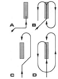
Patterns which can be used for circling approaches are shown in Figure 12-12. Pattern "A" can be flown when your final approach course intersects the runway centerline at less than a 90° angle and you sight the runway early enough to establish a base leg. If you sight the runway too late to fly pattern "A," you can circle as shown in "B." You can fly pattern "C" if it is desirable to land opposite the direction of the final approach and the runway is sighted in time for a turn to downwind leg. If the runway is sighted too late for a turn to downwind as shown in "C," you can fly pattern "D."
Figure 12-12. Circling approaches.
 |
Sound judgment and knowledge of your capabilities and the performance of your aircraft are the criteria for determining the pattern to be flown in each instance, since airport design, ceiling and visibility, wind direction and velocity, final approach course alignment, distance from the final approach fix to the runway, and ATC instructions must all be considered.