![]()
|
|
||
| CHAPTER 1—Rules, Regulations, and Aids for Navigation
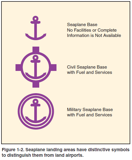
14 CFR PART 91, SECTION 91.115 RIGHT-OF-WAY RULES:WATER OPERATIONS The right-of-way rules for operation on water are similar, but not identical, to the rules governing rightof- way between aircraft in flight. (a) General. Each person operating an aircraft on the water shall, insofar as possible, keep clear of all vessels and avoid impeding their navigation, and shall give way to any vessel or other aircraft that is given the right-of-way by any rule of this section. (b) Crossing. When aircraft, or an aircraft and a vessel, are on crossing courses, the aircraft or vessel to the other’s right has the right-of-way. (c) Approaching head-on. When aircraft, or an aircraft and a vessel, are approaching head-on, or nearly so, each shall alter its course to the right to keep well clear. (d) Overtaking. Each aircraft or vessel that is being overtaken has the right-of-way, and the one overtaking shall alter course to keep well clear. (e) Special circumstances. When aircraft, or an aircraft and a vessel, approach so as to involve risk of collision, each aircraft or vessel shall proceed with careful regard to existing circumstances, including the limitations of the respective craft. RULES OF THE SEA According to United States Coast Guard (USCG) regulations, the definition of a vessel includes virtually anything capable of being used for transportation on water, including seaplanes on the water. Therefore, any time a seaplane is operating on the water, whether under power or not, it is required to comply with USCG navigation rules applicable to vessels. Simply adhering to 14 CFR part 91, section 91.115 should ensure compliance with the USCG rules. Pilots are encouraged to obtain the USCG Navigation Rules, International-Inland, M16672.2D, available from the U.S. Government Printing Office. These rules apply to all public or private vessels navigating upon the high seas and certain inland waters. INLAND AND INTERNATIONAL WATERS Inland waters are divided visually from international waters by buoys in areas with frequent ocean traffic. Inland waters are inshore of a line approximately parallel with the general trend of the shore, drawn through the outermost buoy. The waters outside of the line are international waters or the high seas. Seaplanes operating inshore of the boundary line dividing the high seas from the inland waters must follow the established statutory Inland Rules (Pilot Rules). Seaplanes navigating outside the boundary line dividing the high seas from inland waters must follow the International Rules of the Sea. All seaplanes must carry a current copy of the rules when operating in international waters. UNITED STATES AIDS FOR MARINE NAVIGATION For safe operations, a pilot must be familiar with seaplane bases, maritime rules, and aids to marine navigation. SEAPLANE LANDING AREAS The familiar rotating beacon is used to identify lighted seaplane landing areas at night and during periods of reduced visibility; however, the colors alternate white and yellow for water landing areas. A double white flash alternating with yellow identifies a military seaplane base. On aeronautical charts, seaplane landing areas are depicted with symbols similar to land airports, with the addition of an anchor in the center. As with their land counterparts, tick marks around the outside of the symbol denote a seaplane base with fuel and services available, and a double ring identifies military facilities. [Figure 1-2]
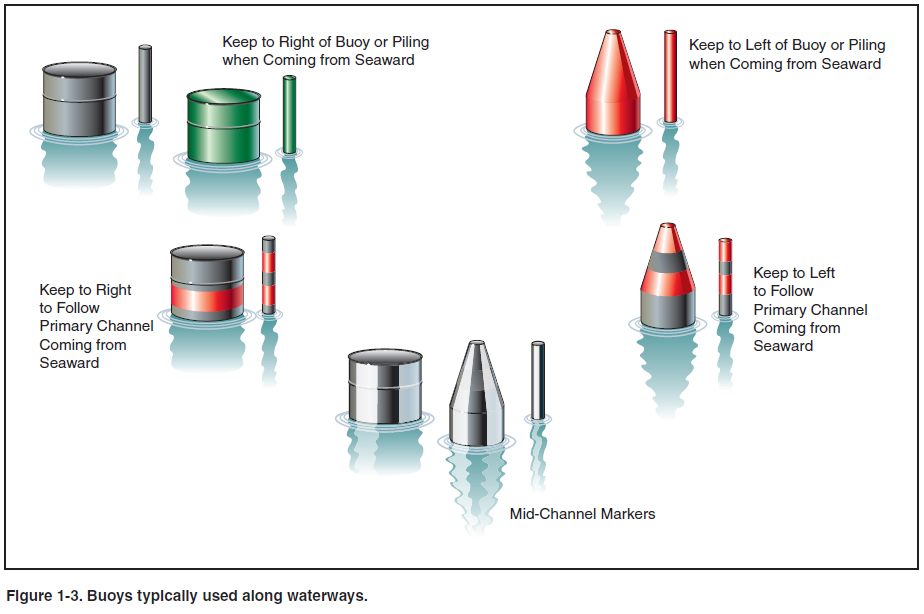
BUOYS AND DAYBEACONS Buoys are floating markers held in place with cables or chains to the bottom. Daybeacons are used for similar purposes in shallower waters, and usually consist of a marker placed on top of a piling or pole driven into the bottom. Locations of buoys within U.S. waters are shown on nautical charts prepared by the Office of Coast Survey (OCS), an office within the National Oceanic and Atmospheric Administration (NOAA). Light lists prepared by the Coast Guard describe lightships, lighthouses, buoys, and daybeacons maintained on all navigable waters of the United States. The buoyage system used in the United States employs a simple arrangement of colors, shapes, numbers, and lights. Whenever operating near buoys, keep in mind that the length of chain holding the buoy in place is likely to be several times the depth of the water, so the buoy may be some distance from its charted location, as well as from any danger or obstruction it is intended to mark. Do not come any closer to a buoy than necessary. Buoys with a cylindrical shape are called can buoys, while those with a conical shape are known as nun buoys. The shape often has significance in interpreting the meaning of the buoy. [Figure 1-3]
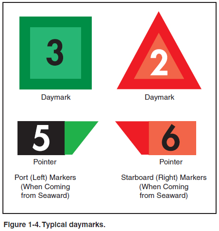
Since a buoy’s primary purpose is to guide ships through preferred channels to and from the open sea, the colors, shapes, lights, and placement become meaningful in that context. Approaching from seaward, the left (port) side of the channel is marked with black or green can buoys. These buoys use odd numbers whose values increase as the vessel moves toward the coast. They also mark obstructions that should be kept to the vessel’s left when proceeding from seaward. The right side of the channel, or obstructions that should be kept to the vessel’s right when headed toward shore, are marked with red nun buoys. These buoys use even numbers whose values increase from seaward. The mnemonic “red, right, returning” helps mariners and seaplane pilots remember to keep the red buoys to their right when proceeding toward the shore (“returning” to their home port). Black and white vertically striped buoys mark the center of the channel or fairway (the nautical term for the navigable part of a river, bay, or harbor), and may use letters starting at A from seaward. Naturally, not all waterways lead straight from ocean to port, so there are also buoys to mark the junctions of waterways. Buoys with red and black horizontal bands mark junctions or places where the waterway forks. They also mark wrecks and obstructions that can be passed on either side. The color of the top band (red or black) and the shape of the buoy (nun or can) indicate the side on which the buoy should be passed by a vessel proceeding inbound along the primary channel. If the topmost band is black, the buoy should be kept to the left of an inbound vessel. If the topmost band is red, keep the buoy to the right when inbound. Buoys with the black top band will usually be cans, while those with the red top band will usually be nuns. For waterways that run more or less parallel to the coast, there is no obvious inbound or outbound to give direction to the waterway, so by convention the inbound direction of such waterways is assumed to be “clockwise” around the contiguous states. This means that for waterways running parallel to the east coast, southbound is considered the inbound direction; for waterways along the Gulf coast, inbound means westbound; and for waterways along the west coast, northbound is inbound. Daybeacons and daymarks serve similar purposes as buoys and use similar symbology. In the United States, green is replacing black as the preferred color for portside daymarks. [Figure 1-4]
These are just the most basic features of the most common buoyage system in the United States. There are other buoyage systems in use, both in the United States and in other countries. Sometimes the markings are exactly the opposite of those just described. Good pilots will obtain a thorough understanding of the maritime aids to navigation used in the areas where they intend to fly. |
| ©AvStop Online Magazine Contact Us Return To Books |