![]()
|
|
||
| CHAPTER 8—Emergency Open Sea Operations
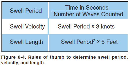
SWELL SYSTEM EVALUATION The purpose of the swell system evaluation is to determine the surface conditions and the best heading and technique for landing. Perform a high reconnaissance, a low reconnaissance, and then a final determination of landing heading and touchdown area. HIGH RECONNAISSANCE During the high reconnaissance, determine the swell period, swell velocity, and swell length. Perform the high reconnaissance at an altitude of 1,500 to 2,000 feet. Fly straight and level while observing the swell systems. Perform the observation through a complete 360º pattern, rolling out approximately every 45º. Fly parallel to each swell system and note the heading, the direction of movement of the swell, and the direction of the wind. To determine the time and distance between crests, and their velocity, follow these directions:
LOW RECONNAISSANCE Perform the low reconnaissance at 500 feet to confirm the findings of the high reconnaissance and obtain a more accurate estimate of wind direction and velocity. If the direction of the swell does not agree with the direction noted at 2,000 feet, then there are two swell systems from different directions. The secondary swell system is often moving in the same direction as the wind and may be superimposed on the first swell system. This condition may be indicated by the presence of periodic groups of larger-than-average swells. The wind direction and speed can be determined by dropping smoke or observing foam patches, whitecaps, and wind streaks. Whitecaps fall forward with the wind but are overrun by the waves. Thus, the foam patches appear to slide backward into the direction from which the wind is blowing. To estimate wind velocity from sea surface indications, see figure 8-1. SELECT LANDING HEADING When selecting a landing heading, chart all observed variables and determine the headings that will prove the safest while taking advantage of winds, if possible. Descend to 100 feet and make a final evaluation by flying the various headings and note on which heading the sea appears most favorable. Use the heading that looks smoothest and corresponds with one of the possible headings selected by other criteria. Consider the position of the sun. A glare on the water during final approach might make that heading an unsafe option. Use caution in making a decision based on the appearance of the sea. Often a flightpath directly downswell appears to be the smoothest, but a landing on this heading could be disastrous. |
| ©AvStop Online Magazine Contact Us Return To Books |