
![]()
|
|
||
| CHAPTER 5. Prefl ight and Ground Operations
Prefl ight Actions A pilot must become familiar with all available information concerning the fl ight, including runway lengths at airport of intended use, takeoff and landing distance accounting for airport elevation and runway slope, aircraft gross weight, wind, and temperature. For a cross-country fl ight not in the vicinity of the takeoff/departure airport, information must include weather reports and forecasts, fuel requirements, and alternatives available if the planned fl ight cannot be completed. Weather Weather is a determining factor for all fl ight operations. Before any fl ight is considered, pilots should obtain regional and local information to fi rst determine if the predicted weather for the planned fl ight is safe. Regional Weather Understanding the overall weather in the region being fl own provides an overview of conditions and how they can change during fl ight. Fronts, pressure systems, isobars, and the jet stream determine the weather. There are a number of information resources from which to fi nd the regional view of weather systems, observed and predicted. Surface analysis charts show these regional systems, which are common on weather internet sites and TV broadcasts. [Figure 5-4] Review the Pilot’s Handbook of Aeronautical Knowledge for a comprehensive understanding of weather theory, reports, forecasts, and charts for weather concepts covered throughout this weather section. 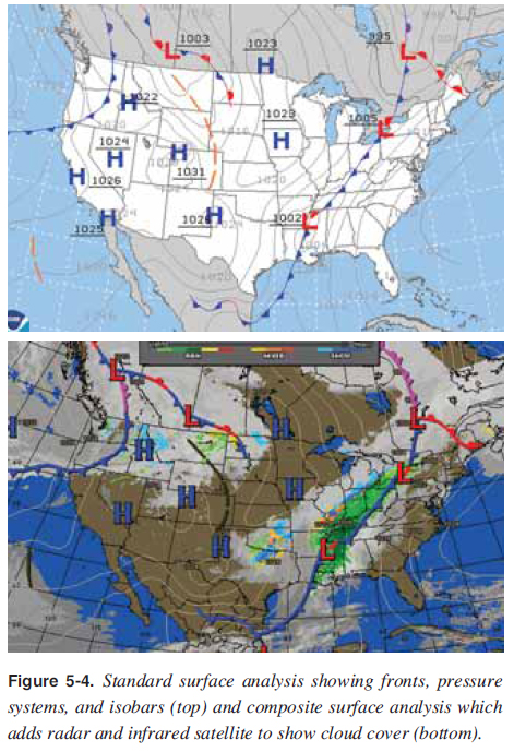 There are many sources for obtaining a weather briefi ng, such as www.aviationweather.gov, www.nws.noaa.gov, 1-800-WX-BRIEF, and a variety of internet sites that specialize in local and regional weather. Local Conditions In gathering weather information for a fl ight, obtain current and forecast conditions where fl ying, as well as alternate airports in case landing at the intended destination is not possible. These conditions should include wind (surface and winds aloft), moisture, stability, and pressure. Surface wind predictions and observations can be looked at with a number of internet resources. The National Weather Aviation service provides observations (METAR) and forecasts (TAF) for areas with weather reporting capabilities. Winds aloft are forecast winds at higher altitudes than the surface for locations throughout the United States. Refer to the Pilot’s Handbook of Aeronautical Knowledge for an understanding of the winds and temperatures aloft tables. Winds aloft, too, are important for flight planning and safety. A typical situation during morning hours is cold air from the night settling, creating calm winds at the surface with the winds aloft (300 to 3,000 feet) at 30 knots. As the surface begins to warm from the sun, the cold surface air starts to warm and rise, allowing the high winds from above to mix and lower to the surface. The wind sheer area in between the high winds above and calm winds below is usually turbulent and can overwhelm aircraft or pilot capabilities. Therefore, it is a dangerous practice to look only at the wind sock for surface winds when there could be strong winds above. Winds aloft must be evaluated for safe fl ight. [Figure 5-5] 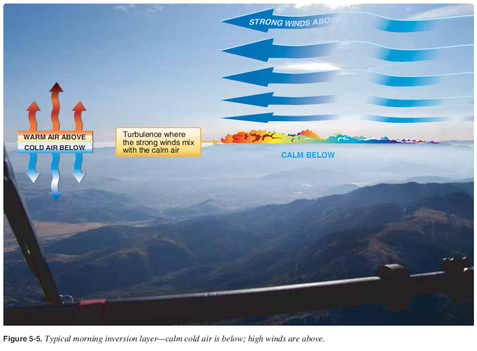
During initial solo fl ights, the wind should be relatively calm to fl y safely. As experience is gained, pilot wind limitations can be increased. It is not until the pilot has had dual training in crosswinds, bumpy conditions, and signifi cant pilot in command (PIC) time soloing in mild conditions that pilot wind conditions should approach the aircraft limitations. A safe pilot understands aircraft and personal limitations. Moisture in the air has a signifi cant effect on weather. If the relative humidity is high, the chance of clouds forming at lower altitudes is more likely. Clouds forming at lower altitudes create visibility problems that can create Instrument Meteorological Conditions (IMC) in which the visibility is below that required for safe fl ight. The temperature-dew point spread is the basis for determining at what altitude moisture condenses and clouds form. It is important to be particularly watchful for low visibilities when the air and dew point temperatures are within a spread of three to four degrees. The closer these temperatures are to each other, the greater the chance for fog or clouds forming with reduced visibility conditions. Consider a scenario where the destination airport currently has a temperature-dew point spread of 4 °F, and it is evening when the atmosphere is cooling down. Since the temperature-dew point convergence rate is 4.4° for every thousand feet, the clouds/ceiling would be about 1,000 feet above ground level (AGL). Since it is cooling down, the temperature-dew point spread is decreasing, lowering the cloud level. Therefore, the 1,000 foot AGL ceiling is lowering, creating IMC conditions that are not safe. For this scenario, the fl ight should not be attempted. Air temperature and humidity directly affect the performance of the WSC wing and engine. The higher the temperature, humidity, and actual altitude of the operating fi eld, the greater role density altitude plays in determining how much runway the WSC aircraft needs to get off the ground with the load on board, and how much climb performance is required once airborne. The WSC aircraft may have cleared the obstacle at 8 a.m. when the weather conditions were cooler with less humidity; at 1 p.m. with increased air temperature and higher humidity levels, the pilot must reevaluate the performance of that same aircraft. A full understanding of density altitude is necessary to be a safe WSC pilot; refer to the Pilot’s Handbook of Aeronautical Knowledge for density altitude and weight effects on performance. The rate of temperature decrease with increased altitude determines the stability of the air. The stability of the air determines the vertical air currents that develop during the day as the area is heated by the sun. These rising vertical air currents are commonly known as thermals. Generally, stable air has mild thermals and therefore less turbulence than unstable air. Unstable air rises faster, creating greater turbulence. Highly unstable air rises rapidly and, with enough moisture, can build into thunderstorms. Air stability is easily determined by the rate at which the temperature drops with increased altitude. A standard atmosphere is where the temperature drops 2 °C for every 1,000 foot increase. If the temperature drops less than 2 °C per thousand feet, the air is more stable with less vertical wind (thermals) developed during the day. If the temperature drops more than 2 °C per thousand feet, the air is more unstable with more powerful vertical air currents developed during the day, creating greater turbulence. In addition to air stability, barometric pressure has a large effect on weather. Low pressure in the area, below the standard atmosphere of 29.92 "Hg, is generally rising air with dynamic and unsettled weather. High pressure above the standard atmosphere in the area is generally sinking air resulting in good weather for fl ying. Many airports have automated weather systems in which pilots can call the automated weather sensor platforms that collect weather data at airports and listen to this information via radio and/or land line. Radio frequencies are on the sectional chart and the A/FD has the telephone numbers for these stations. The systems currently available are the Automated Surface Observing System (ASOS), Automated Weather Sensor System (AWSS), and Automated Weather Observation System (AWOS). Local conditions of wind, moisture, stability, and barometric pressure are factors that should be researched before fl ight to make a competent decision of go or no go to fl y. High winds and moist unstable air with a low barometric pressure indicate undesirable fl ying conditions. Light winds and dry stable air with high pressure indicate favorable fl ying conditions. Pilots should research and document these local conditions before fl ight to predict the fl ying conditions and compare the actual fl ying conditions to the predictions to learn and develop knowledge from the information resources available for fl ight. In addition to weather, the National Airspace needs to be checked to ensure there are no temporary fl ight restrictions (TFR) for the locations planned to fl y. TFRs may be found at www.tfr.faa.gov/. For a complete prefl ight briefi ng of weather and TFRs, call 1-800-WX-BRIEF. Clouds visually tell what the air is doing, which provides valuable information for any flight. To understand the different cloud formations and the ground/air effects produced, refer to weather theory in the Pilot’s Handbook of Aeronautical Knowledge. [Figure 5-6] Cloud clearance and visibility should be maintained for the operations intended to be conducted. The chapter covering the National Airspace System (NAS) provides cloud clearance requirements in each class of airspace. A pilot should not fl y when ground and fl ight visibility are below minimums for his or her pilot certifi cate and the class of airspace where operating. 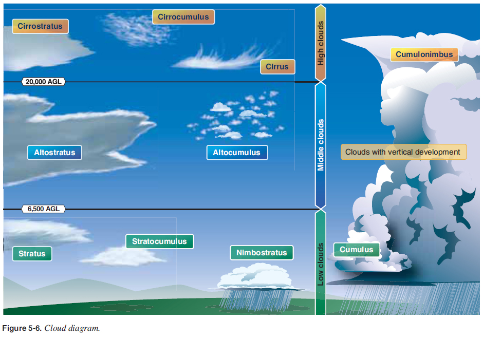 Knowledge of mechanical turbulence and how to determine where it can occur is also important. The lee side of objects can feel turbulence from the wind up to ten times the height of the object. The stronger the wind is, the stronger the turbulence is. [Figures 5-7 and 5-8] 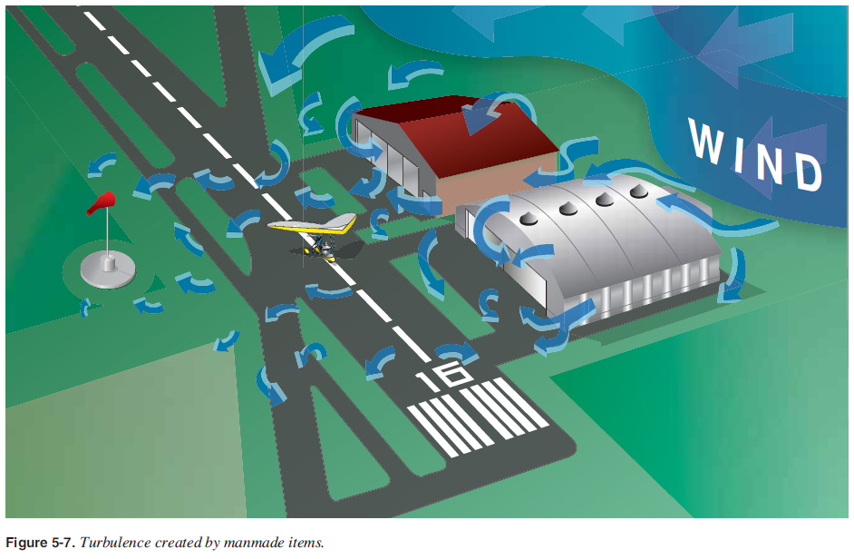 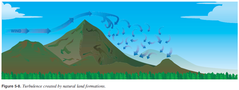 In addition to adhering to the regulations and manufacturer recommendations for weather conditions, it is important to develop a set of personal minimums such as wind limitations, time of day, and temperature-dew point spread. These minimums will evolve as a pilot gains experience and are also dependent on recency and currency in the make/model of aircraft being fl own. |
| ©AvStop Online Magazine Contact Us Return To Books |
