![]()
|
|
||
| CHAPTER 8. The National Airspace System
Airspace Above 10,000' MSL and Below 18,000' For WSC aircraft fl ying above 10,000 feet MSL, the visibility must be greater than 5 SM and cloud clearances increase to 1,000 feet below, 1,000 feet above, and 1 SM horizontal. If the WSC aircraft was not certifi cated with an electrical system, an altitude encoding transponder is required per 14 CFR section 91.215. Oxygen is required for the pilot above 12,500 MSL up to and including 14,000 feet MSL if the fl ight at those levels is more than 30 minutes duration. At altitudes above 14,000 feet MSL, oxygen is required for the pilot during the entire fl ight time at those altitudes. At altitudes above 15,000 feet MSL, each occupant of the aircraft must be provided with supplemental oxygen. Class A Airspace Class A airspace is generally the airspace from 18,000 feet MSL up to and including FL 600, including the airspace overlying the waters within 12 NM of the coast of the 48 contiguous states and Alaska. Unless otherwise authorized, all operations in Class A airspace are conducted under IFR. Class A airspace is not applicable to WSC pilots. Special Use Airspace Special use airspace is the designation for airspace in which certain activities must be confi ned, or where limitations may be imposed on aircraft operations that are not part of those activities. Special use airspace usually consists of:
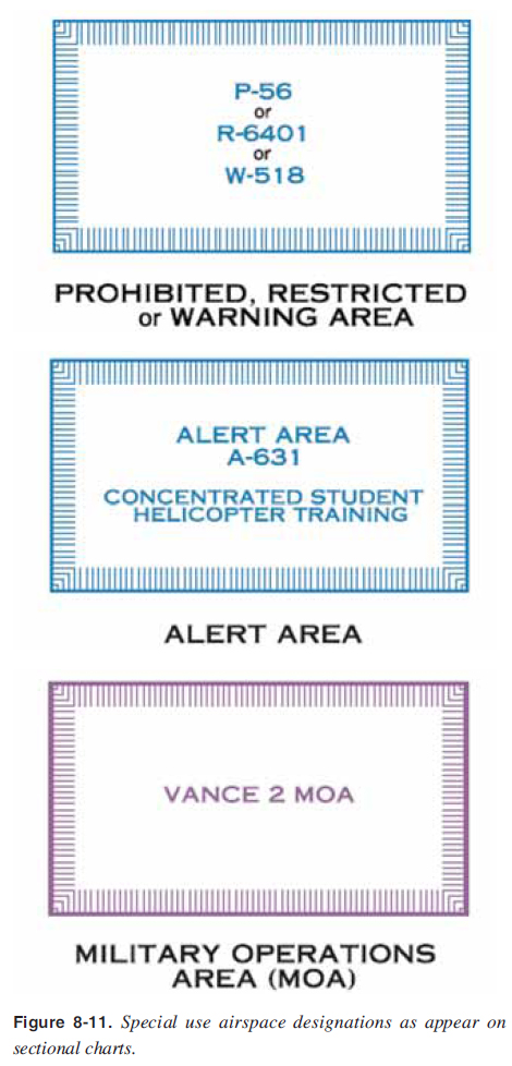
Except for controlled firing areas, special use airspace areas are depicted on visual sectional charts. [Figure 8-11] Controlled fi ring areas are not charted because their activities are suspended immediately when spotter aircraft, radar, or ground lookout positions indicate an aircraft might be approaching the area. Nonparticipating aircraft are not required to change their fl ightpaths. Special use airspace areas are shown in their entirety (within the limits of the chart), even when they overlap, adjoin, or when an area is designated within another area. The areas are identifi ed by type and identifying name or number, positioned either within or immediately adjacent to the area. [Figure 8-11]
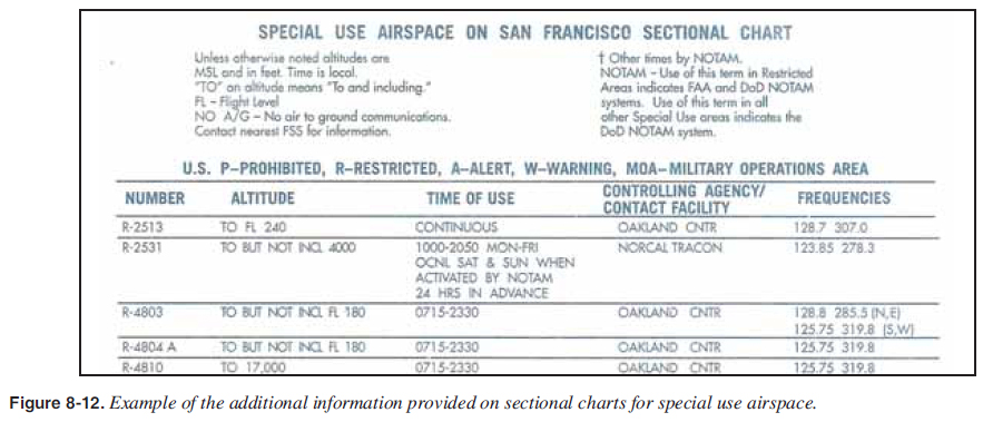
Prohibited, restricted or warning areas; alert areas; and MOAs are further defi ned with tables on sectional charts for their altitudes, time of use, controlling agency/contact facility and controlling agency contact frequency. [Figure 8-12]
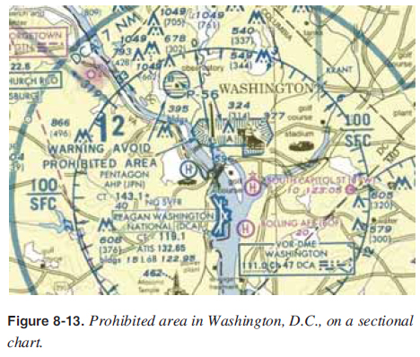
Prohibited Areas Prohibited areas contain airspace of defi ned dimensions within which the fl ight of aircraft is prohibited. Such areas are established for security or other reasons associated with the national welfare. These areas are published in the Federal Register and are depicted on sectional charts. The area is charted as a “P” followed by a number (e.g., “P-56 A and B”). [Figure 8-13]
|
| ©AvStop Online Magazine Contact Us Return To Books |