![]()
|
|
||
| CHAPTER 8. The National Airspace System
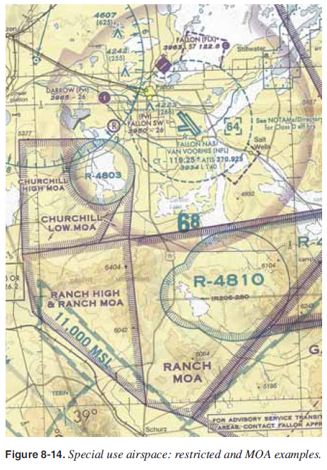
Restricted Areas Restricted areas are areas where operations are hazardous to nonparticipating aircraft and contain airspace within which the fl ight of aircraft, while not wholly prohibited, is subject to restrictions. Activities within these areas must be confi ned because of their nature, or limitations may be imposed upon aircraft operations that are not a part of those activities, or both. Restricted areas denote the existence of unusual, often invisible, hazards to aircraft (e.g., artillery fi ring, aerial gunnery, or guided missiles). Penetration of restricted areas is illegal without authorization from the using or controlling agency may be extremely hazardous to the aircraft and its occupants. ATC facilities apply the following procedures:
Restricted areas are charted with an “R” followed by a number (e.g., “R-4803 and R-4810”) and are depicted on the sectional charts. [Figure 8-14]
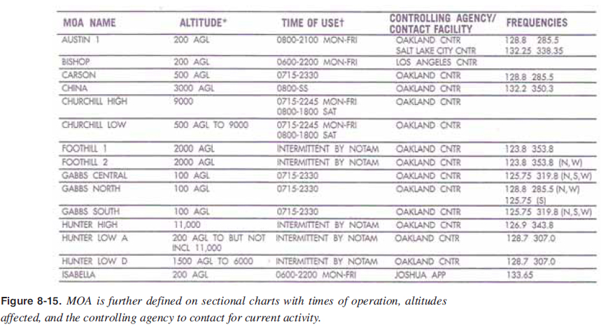
Warning Areas Warning areas consist of airspace which may contain hazards to nonparticipating aircraft in international airspace. The activities may be much the same as those for a restricted area. Warning areas are established beyond the three mile limit and are depicted on sectional charts. Military Operations Areas (MOAs) MOAs consist of airspace of defi ned vertical and lateral limits established for the purpose of separating certain military training activity from IFR traffi c. There is no restriction against a pilot operating VFR in these areas; however, a pilot should be alert since training activities may include acrobatic and abrupt maneuvers. MOAs are depicted by name and with defi ned boundaries on sectional, VFR terminal area, and en route low altitude charts and are not numbered (e.g., “CHURCHILL HIGH MOA,” “CHURCHILL LOW MOA,” “RANCH HIGH & RANCH MOA” and “RANCH MOA”). [Figure 8-14] MOA is further defi ned on sectional charts with times of operation, altitudes affected, and the controlling agency frequency for the MOA to contact for current activity. [Figure 8-15]
|
| ©AvStop Online Magazine Contact Us Return To Books |