10 Years After Fatal Plane Crash, Family
Members Continue To Search For Answers
December 21, 2015 - At
approximately 11:40 PM on Thursday, April 20,
2006, a Cessna U206G aircraft, registration
N120HS, crashed while on a precision approach
for runway 35 at the Monroe County Airport
(BMG), near Bloomington, Indiana killing all
five onboard.
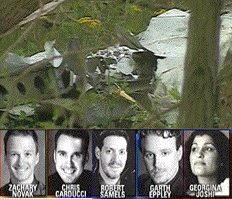
The pilot and passengers were identified as
students attending Indiana University, the pilot
was Georgina Joshi and the passengers were Garth
Eppley, Chris Carducci, Robert Samels and
Zachary Novak. The five students, best of
friends, were accomplished musical performers
returning to their graduate program at Indiana
University from a rehearsal in Lafayette, Ind.
The parents of these students are searching for
answers that caused this plane crash. For five
families this year marks the 10th holiday season
without loved ones after a tragic 2006 airplane
crash without the answers needed for closure.
They have spent the better part of the last
decade searching for the truth.
“It was the
most heartbreaking day of my life when we found
out,” said Yatish Joshi, father of Georgina. “To
make matters worse, the ensuing investigation by
the National Transportation Safety Board (NTSB)
did not leave us with peace of mind.”
The NTSB issued its Probable Cause Report more
than a year later (445 days), ruling the cause
of the crash as ‘pilot error’. The report stated
the pilot's continued descent below decision
height and not maintaining adequate
altitude/clearance from the trees while on
approach was the probable cause of the crash.
Other factors contributed to the crash included
night lighting conditions, and the mist.
Mr. Joshi stated, "The report left many
questions unanswered." As a result, Joshi sought
out technical experts who performed their own
investigation, recreated the accident flight,
interviewed witnesses, and performed acoustic
testing to determine the accident’s cause. The
experts realized that many of the witnesses who
heard or saw a plane shortly before the accident
were describing a different plane than
Georgina’s.
Joshi and his experts concluded that the
Probable Cause Report was flawed and that the more
likely cause(s) of the accident included: (a) a second
plane flying below FAA radar attempting to land on a
perpendicular runway as Georgina was approaching the
airport; and (b) flaws in the airport air traffic
control system for night landings.
Joshi submitted his evidence to the NTSB in a Petition
for Reconsideration asking the NTSB to reexamine its
probable cause determination. In its response, the NTSB
dismissed this evidence in part because “none of the
[911] callers reported hearing more than one airplane
during the time surrounding the accident.” The NTSB
wrote, "After review of the evidence, the petition for
reconsideration of the NTSB’s probable cause in
connection with the aircraft accident involving a Cessna
206, N120HS, on April 20, 2006, near Bloomington,
Indiana, is denied in its entirety."
In 2008, Joshi petitioned the D.C. Circuit Court for
review of the NTSB’s denial of his Petition. In court
Joshi argued that the NTSB’s investigation and analysis
was fundamentally flawed because they refused to
“consider relevant factors”, those factors being what
Joshi and his investigators had learned when they
conducted their own investigation.
The D.C. Circuit Court dismissed Joshi’s petition for
lack of jurisdiction. The court said, in essence it
didn't have the jurisdiction to make the NTSB change its
report findings and is not subject to judicial review
(National Transportation Safety Board accident reports
are not subject to judicial review).
Joshi appealed
his case before the U.S. Court of Appeals for the
District Of Columbia on June 19, 2015 and the court
sided with the lower court and dismissed the case. Joshi
has now filed his case with the
United States
Supreme Court. He is asking the court to decide
whether the lower courts have the jurisdiction to review
the NTSB findings.
After reviewing the NTSB report of the crash, it appears
the pilot had some reservations in taking off and flying
in bad weather (IFR conditions), had minimum IFR flight
hours for flight conditions, appeared to be distracted,
did not perform a proper preflight and following air
traffic controller instructions during the precision
approach. However, if Joshi's findings are correct it
will be interesting to see if the court addresses this
issue. Below is the NTSB report of the accident and
radio communications with the pilot and ATC just prior
to the crash.
HISTORY OF FLIGHT
(NTSB
Identification:
CHI06FA117)
On April 20, 2006, about 2345 eastern daylight time, a
Cessna U206G, N120HS, piloted by an instrument rated
private pilot, was destroyed on impact with trees and
terrain while on approach to runway 35 at the Monroe
County Airport (BMG), near
Bloomington, Indiana. The personal flight was operating
under the provisions of 14 Code of Federal Regulations
Part 91. Night instrument meteorological conditions
prevailed at the time of the accident. An instrument
flight rules (IFR) flight plan was on file and was
activated. The pilot and four passengers sustained fatal
injuries. The flight originated from the Purdue
University Airport (LAF), near
Lafayette,
Indiana, about 2245.
The person representing N120HS contacted the Terre Haute, Indiana
federal contract facility automated flight service
station (AFSS) to get a weather briefing about 2213. The
AFSS briefer at position "PF-3" gave the following
brief, in part, to the pilot:
2213:25 PF-3 terre haute flight service
2213:27 N120HS hi i'd like to get a weather briefing
2213:29 PF-3 yes ma'am
2213:30 N120HS um lafayette lima alpha foxtrot and
bloomington bravo mike golf and any interesting weather
that might be between them
2213:39 PF-3 okay uh what's the aircraft call sign
you're using
2213:42 N120HS november one two zero hotel sierra
2213:45 PF-3 and what time are you leaving lafayette
2213:47 N120HS we will probably be leaving in about
twenty minutes to half an hour
2213:58 PF-3 okay and is this a v f r flight or i f r
2214:02 N120HS for v f r
2214:03 PF-3 v f r only
2214:05 N120HS *(ho ho) wait i'm sorry go ahead
2214:08 PF-3 is that v f r only
2214:10 N120HS yes yes sir well depending on what the
weather's like
2214:13 PF-3 okay well we do have an airmet for i f r
for the southern portion of indiana now
0214:18 N120HS okay
0214:19 PF-3 and they're saying that that may continue
the rest of the evening into early tomorrow morning and
2214:23 N120HS okay
2214:23 PF-3 looking at the bloomington weather they do
have i f r ceilings eight hundred broken right now with
visibility eight miles
2214:30 N120HS *(okay)
2214:30 PF-3 so i wouldn't recommend v f r
2214:32 N120HS okay well
2214:33 PF-3 uh
2214:33 N120HS definitely not i'm sorry i got i looked
at the *(tafs they) didn't predict that okay can i file
an i f r flight plan with you
2214:39 PF-3 sure would you like me to continue with the
rest of the weather and and all that
2214:42 N120HS yeah that would that would be great
2214:44 PF-3 okay uh that's the only airmet uh going
down that way for you uh looks like a low pressure
system we've got uh one in western kentucky tennessee
another one's up around the chicago area *(it's a)
stationary front running from that one across northern
indiana and ohio and then uh high pressure over to our
east precip uh nothing really along that route there is
some in southeastern indiana but it shouldn't affect
your flight at all
2215:08 N120HS *(okay)
2215:08 PF-3 at lafayette uh the winds are two eighty at
four ten miles skies clear below twelve thousand sixteen
and seven and two nine nine one that's an automated
report en route looking at a few clouds at thirteen
thousand with niner miles and then again in the
bloomington area winds two forty at three eight miles
ceiling eight hundred broken seventeen and sixteen and
two nine nine four that's also an automated report at
bloomington and i don't see any uh pilot reports right
now along that route for you the forecast lafayette was
saying the rest of the evening a few clouds at six
thousand winds three ten at five en route uh calling for
*(uh) it looks like three thousand scattered six to ten
thousand broken to overcast they were saying occasional
showers in central indiana til zero three hundred though
there's nothing really showing except for a little
northeast of indy and then uh for the bloomington area
uh six hundred broken five thousand overcast visibility
better than six winds one sixty at four now they were
saying within an hour you might see six hundred
scattered five in mist around bloomington four hun four
thousand broken and winds one fifty at four but the
airmet was calling for i f r to continue the rest of the
night into early tomorrow
2216:26 N120HS boy am i glad i called you wow
2216:27 PF-3 and
2216:28 N120HS okay
2216:28 PF-3 and then winds aloft uh would you like
three and six for those
2216:32 N120HS um just three please
2216:33 PF-3 three thousand you're looking at light and
variable winds at three thousand
2216:37 N120HS okay great
2216:38 PF-3 and notams uh lafayette r c o one two two
three five is out of service
2216:44 PF-3 and uh it says the class d surface area and
uh tower only available through zero one hundred daily
down at Bloomington uh showing tower and class d surface
area available through zero one thirty daily and three
five pilot controlled lighting is out of service at
bloomington indiana and otherwise en route i don't see
anything else en route for you notam d wise as far as t
f rs no unpublished t f rs along that route at this time
2217:15 N120HS *(great)
2217:15 PF-3 *(we'd) appreciate uh pilot reports flight
watch is shut down for the evening but any any flight
service frequencies along the route for you would you
like to go ahead and file then
2217:24 N120HS yes sir
2217:25 PF-3 okay i'm ready to copy
2217:26 N120HS (unintelligible) november one two zero
hotel sierra it's a cessna two oh six slash alpha
airspeed a hundred and a hundred and thirty knots flying
at three
thousand feet departing lafayette lima alpha foxtrot
lafayette direct bloomington indiana bravo mike golf
five on board three hours of fuel the aircraft is based
in south bend pilots name ... and aircraft is red white
and blue
2218:12 PF-3 (unintelligible) uh what's your time en
route from lafayette to bloomington
2218:15 N120HS time on route forty minutes
2218:19 PF-3 and you say you're leaving in just a few
minutes i put that out for zero two thirty that's on the
half hour
2218:23 N120HS *(perfect)
The transcript of the weather briefing showed that the
pilot did not give an alternate airport to the briefer
when the flight plan was filed. The briefer did not ask
for an alternate airport and was not required to ask for
one.
About 2319, the pilot checked on with the AirRouteTrafficControlCenter controller working
the Shelbyville, Indiana, sector (SHB R). The transcript
of their transmissions, in part, stated:
2319:57 N120HS indy center november one two zero hotel
sierra is with you at five thousand
2320:01 SHB R november one two zero hotel sierra
indianapolis center roger how do you
hear center
2320:04 N120HS ah loud and clear
2320:05 SHB R okay and ah what type of approach are you
going to shoot into bloomington this morning or this
evening
2320:11 N120HS we'd like to go for a runway three five
six ah i l s
2320:14 SHB R i l s three five okay you can expect that
ah one two zero hotel sierra do you have the ah asos
weather
2320:19 N120HS yes sir
2320:20 SHB R all right
2323:11 SHB R cessna one two zero hotel sierra you're
one two miles north of bloomington cross bloomington at
or above two thousand six hundred cleared for the i l s
runway three five approach report procedure turn inbound
2323:23 N120HS oh any way we can have vectors to
the---ah final course
2323:26 SHB R not a problem at all ma'am what's your
heading
2323:30 N120HS one seven zero
2323:32 SHB R okay turn ah right heading of ah one nine
zero it'll be a vector for a left down wind entry for i
l s three five straight in
2323:39 N120HS one niner zero for a---right down wind
entry ah for three five zero hotel sierra
2323:43 SHB R yes ma'am and maintain five thousand
2323:46 N120HS maintain five thousand
2328:35 SHB R cessna one two zero hotel turn left
heading one eight zero
2328:39 N120HS left heading one eight zero
...
2333:03 SHB R cessna one two zero hotel sierra descend
at pilot's discretion maintain four thousand
2333:08 N120HS descend and maintain four thousand for
zero hotel sierra
2333:13 SHB R i am going to take you about two miles
outside of claye if that's okay with you ma'am
2333: 18 N120HS that's great
2333:50 SHB R cessna one two zero hotel sierra turn left
heading zero eight zero
2333:53 N120HS left heading zero eight zero
2334:36 SHB R cessna one two zero hotel sierra three and
a half miles south of claye turn left heading zero two
zero maintain two thousand six hundred until established
on the localizer you're cleared straight in i l s runway
three five approach
2334:48 N120HS turn left heading zero two zero---cleared
for the approach maintain twenty six hundred til ah
established zero hotel sierra
2336:15 SHB R cessna one two zero hotel sierra see you
joining up on the localizer now radar service is
terminated change to advisory tower frequency of one two
eight point zero two is approved---and i'll need you to
cancel---with ah terre haute tower on that frequency one
two eight point zero two they monitor that frequency and
they'll
relay for ya
2336:35 N120HS radar service terminated and cancel with
terre haute on one two eight point zero two thanks
(unintelligible) zero hotel sierra
2336:40 SHB R and you can change to that frequency now
you have a good night
2336:43 N120HS thanks
A Continuous Data Recording (CDR) airplane radar track
data file was obtained from the Federal Aviation
Administration (FAA) in reference to the accident
flight. The airplane's radar returns along with their
respective altitudes and times were plotted. The plotted
data was consistent with an airplane that was being
vectored for an instrument landing system (ILS) approach
to runway (rwy) 35. The plot showed the airplane at
about 5,000 feet on a downwind. At 2334:30, the return
showed the airplane was about 4,500 feet on base about
ten miles from the approach end of runway 35. The
airplane's return at 2337 was right of and approaching
the outer marker CLAYE at an altitude of 3,300 feet.
About 2337, the pilot made an advisory radio call on the
Hulman Approach control frequency for BMG (128.025) that
the flight was six miles south of BMG and inbound for
runway 35. The last plotted return showed the airplane
at 2,000 feet at 2338:34 about two and a half miles from
the approach end of runway 35. About 2343, the
controller from the Terre Haute International Airport-Hulman
Field air traffic control tower, near
Terre Haute, Indiana,
who was working the approach frequency, advised the
flight that the BMG common traffic advisory frequency
(CTAF) was 120.77 and the flight responded with "Thank
you sir." No further communication was recorded with the
accident flight. That plotted chart is appended to the
docket material associated with this case.
About 2345, the Monroe County Sheriff responded to
telephone calls of a possible airplane crash. About
0400, the wreckage was located in a wooded area about
one-half mile from the approach end of runway 35.
Witnesses in the area stated that they were awakened by
a low flying aircraft. A witness said that the airplane
noise was like a roar. Another described it as an engine
acceleration. A thud was heard and no more engine sounds
were heard.
PERSONNEL
INFORMATION
The pilot held a private pilot certificate with
single-engine land, multiengine land, and instrument
airplane ratings. The airplane operator reported that
the pilot had completed a flight review or equivalent on
July 3, 2005. It was further reported that the pilot had
accumulated 379.1 hours of total flight time, 24.5 hours
of actual instrument time, 51.1 hours of simulated
instrument time, 30.4 hours of total flight time in the
previous 90 days, 18.0 hours of total flight time in the
previous 30 days, and 1.8 hours of total flight time in
the previous 24 hours. She held a FAA third-class
medical certificate issued on August 19, 2003, with a
limitation for corrective lenses.
AIRCRAFT
INFORMATION
N120HS, a Cessna U206G, Stationair 6, serial number
U20604728, was a six-place, single engine, high-wing,
all-metal airplane of semimonocoque construction. The
wings were externally braced and each wing contained a
standard integral 46-gallon fuel tank. The airplane was
powered by a six-cylinder, horizontally opposed, air
cooled, fuel injected, marked as a Continental IO-520-F
(17) engine, with serial number 812264-R. The engine was
rated at 300 horsepower for five minutes and 285
horsepower continuously. Maintenance records showed that
the airplane's propeller was a three-bladed McCauley
D3A34C404B model, hub serial number 785309. The airplane
was issued a standard airworthiness certificate and was
certified for normal category operations.
Maintenance records show that the last annual inspection
was performed on June 7, 2005, and that the airplane had
accumulated 2,125.7 hours at the time of that
inspection. An entry in the records showed that the
static system was inspected in accordance with Part
91.411 and 91.413 requirements on May 19, 2005.
The airplane was equipped with a J.P. Instruments Engine
Data Management (EDM) 700 system. According to
manufacturer's data, the EDM will monitor up to
twenty-four critical parameters in your engine, four
times a second, with a linearized thermocouple accuracy
of better than 0.1 percent or 2 degrees F, has a user
selectable index rate, fast response probes,
non-volatile long term memory, records and stores data
up to 30 hours, and has post-flight data retrieval
capabilities.
METEOROLOGICAL
INFORMATION
At 2340, the recorded weather at BMG was: Wind 230
degrees at 5 knots; visibility 1 statute mile; present
weather mist; sky condition overcast 100 feet;
temperature 17 degrees C; dew point 16 degrees C;
altimeter 29.94 inches of mercury.
AIDS TO
NAVIGATION
There were eight non-precision instrument approaches and
one precision approach available at the airport. The
published inbound course for BMG's ILS RWY 35 approach
was 354 degrees magnetic, with the published decision
height (DH) of 1,045 feet msl. The crossing altitude for
the final approach fix (CLAYE) was 2,533 feet msl. The
distance between CLAYE and the missed approach point was
5.1 nautical miles (nm). The airport elevation was 846
feet msl. The published weather minimums for the ILS RWY
35 approach were a 200-foot ceiling and one-half mile
visibility for category A, B, C, and D aircraft. On
April 21, 2006 the FAA conducted a post aircraft
accident technical inspection and found the ILS system
was operating normally.
AIRPORT
INFORMATION
BMG had two asphalt-surfaced runways, 17/35 and 6/24.
Runway 17/35 was 6,500 feet long and 150 feet wide.
Runway 35 was equipped with a medium intensity approach
lighting system with runway alignment indicator lights
(MALSR) and high intensity runway lights (HIRL). Runways
6,17, and 24 were equipped with visual approach slope
indicators (VASI) located on the left side of their
respective runways. The airport was serviced by an Air
Traffic Control tower. The tower was attended from 0630
- 2130 local. After hour local traffic communications
were accomplished via the published airport CTAF 120.775
megahertz (MHz). The tower did not record the CTAF
transmissions made after hours. Indianapolis Approach
provided approach/departure control services for the
airport. The pilot controlled lighting function of the
approach lights was not operative. The approach lights
were turned on before the tower was closed.
WRECKAGE AND
IMPACT INFORMATION
The airplane came to rest inverted on an approximate 180
degree magnetic heading. Broken and linearly separated
tree branches were observed. A tree on a 230 degree
magnetic heading from the wreckage and about 6 feet from
the wreckage contained embedded aluminum colored metal
consistent with the nose wheel rim. The engine was found
about three feet below the surface. The propeller hub
remained attached to the engine crankshaft propeller
flange. The propeller blades separated from their hub.
One blade exhibited forward bending and leading edge
deformation. All of the blades exhibited chordwise
abrasion. The wings were detached from the fuselage. The
outboard section of the left wing had separated from the
inboard section. The rudder was detached from the
empennage and its control cables remained attached.
An on-scene examination of the wreckage was conducted.
Flight control cables were traced. All breaks in cables
were consistent with overload. Flight control continuity
was established from the cabin area to all flight
control surfaces. The engine's control cables were
traced from the cabin to the engine and engine control
continuity was established. A blue liquid consistent
with 100 low lead aviation gasoline was observed in the
left tank.
The wreckage was relocated for a detailed examination
and wreckage layout. The right engine driven vacuum pump
was separated from the accessory case. The pump's drive
coupler was not recovered. The right vacuum pump was
rotated by hand and an inspection revealed that its
rotor and vanes were intact. The left pump was attached
to the accessory case. The pump was crushed and an
inspection revealed its rotor was fragmented. The
sparkplugs were removed and no anomalies were detected.
The engine was rotated by hand and a thumb compression
was observed at all cylinders. The right magneto was
crushed, deformed, and did not produce any spark when
rotated by hand. The left magneto produced spark at all
leads when rotated by hand. The engine driven fuel
pump's coupler was intact. A blue liquid consistent with
100 low lead aviation gasoline was found in the fuel
line from the engine driven fuel pump to the manifold
valve. The attitude indicator and horizontal situation
indicator rotors exhibited rotational scoring. The rotor
housings exhibited witness marks consistent with contact
with their rotors. The altimeter's Kollsman window
indicated 29.91. The airplane's engine monitor was
crushed. The on-scene investigation did not reveal any
pre-impact anomalies.
MEDICAL AND
PATHOLOGICAL INFORMATION
An autopsy was performed on the pilot by the Monroe
County Coroner's Office on April 22, 2006. The FAA Civil
Aeromedical Institute prepared a Final Forensic
Toxicology Accident Report. The report was negative for
the tests performed.
TESTS AND
RESEARCH
The engine monitor was examined at its manufacturer. The
unit and its circuit board were crushed. The data memory
chip was removed from its circuit board and installed on
a serviceable circuit board. The accident flight's data
was downloaded. The downloaded data was graphed. The end
of the graph showed a reduction in fuel flow consistent
with a descent followed by an increase in fuel flow
consistent with a full power setting and the data
stopped at that point. The graph of the engine monitor's
data is appended to the docket material associated with
this investigation.
ADDITIONAL
DATA/INFORMATION
Federal Aviation Regulation Part 91.169 IFR flight plan:
information required, in part, stated:
(a) Information required. Unless otherwise authorized by
ATC, each person filing an IFR flight plan shall include
in it the following information:
(1) Information required under Sec. 91.153(a).
(2) An alternate airport, except as provided in
paragraph (b) of this section.
(b) Exceptions to applicability of paragraph (a)(2) of
this section.
Paragraph (a)(2) of this section does not apply if part
97 of this chapter prescribes a standard instrument
approach procedure for the first airport of intended
landing and, for at least 1 hour before and 1 hour after
the estimated time of arrival, the weather reports or
forecasts, or any combination of them indicate--
(1) The ceiling will be at least 2,000 feet above the
airport elevation; and
(2) The visibility will be at least 3 statute miles.
(c) IFR alternate airport weather minimums. Unless
otherwise authorized by the Administrator, no person may
include an alternate airport in an IFR flight plan
unless current weather forecasts indicate that, at the
estimated time of arrival at the alternate airport, the
ceiling and visibility at that airport will be at or
above the following alternate airport weather minimums:
(1) If an instrument approach procedure has been
published in part 97 of this chapter for that airport,
the alternate airport minimums specified in that
procedure or, if none are so specified, the following
minimums:
(i) Precision approach procedure: Ceiling 600 feet and
visibility 2 statute miles.
(ii) Nonprecision approach procedure: Ceiling 800 feet
and visibility 2 statute miles.
(2) If no instrument approach procedure has been
published in part 97 of this chapter for that airport,
the ceiling and visibility minimums are those allowing
descent from the MEA, approach, and landing under basic
VFR.
The operator's
safety recommendation, in part stated:
Even if a tower is closed, as it was in this case, there
should be an automatic recording of all pilot
transmissions on the common frequency. Such a recording
would make available vital information in the case of a
fatal accident [for example] did the pilot make a
distress call? Does the pilot's voice indicate that they
are under duress? Was it the pilot's intention to do a
missed approach? Was there anything that may have
interfered with the pilot's conduct of the flight? Did
the pilot make any announcement indicating what problem
they were facing? Was there any other aircraft in the
immediate vicinity? The parties to the investigation
included the FAA, Cessna Aircraft Company, and Teledyne
Continental Motors.
Joshi states despite the numerous attempts to locate the
pilot of this other plane the families’ search
continues. The family's of these students are "appealing
to the pilot of the second plane to come forward and
help us discover what happened that evening,” said
Joshi. “During this time of the year, please look into
your heart and help the families of those who were lost
uncover the truth. Your insights will help to put our
hearts and minds to rest, and hopefully prevent similar
accidents in the future.”
Earlier this year, Joshi, a prominent business and
community leader in
South Bend,
Ind., founded the movement Safe
Skies For All (SSFA). SSFA’s mission is to improve
procedures in the investigations of general aviation
accidents and to encourage the NTSB, the government
agency responsible for these investigations to be
accountable for the thoroughness of its investigations,
leading to accurate findings, and to ensure
recommendations are made so that safety is continually
improved.
“The five friends will live on through their amazing
accomplishments and the change we hope to effect,”
continued Joshi. “Through this movement, we want to
ensure other families never have to endure a similar
tragedy.”
Other News Stories
(For the latest news please
checkout our home page)