
Local Area Augmentation System (LAAS)
|
The second augmentation to the GPS signal is the Local Area Augmentation System (LAAS). The LAAS is intended to complement the WAAS and function together to supply users of the U.S. NAS with seamless satellite based navigation for all phases of flight. In practical terms, this means that at locations where the WAAS is unable to meet existing navigation and landing requirements (such as availability), the LAAS will be used to fulfill those requirements. In addition, the LAAS will meet the more stringent Category II/III requirements that exist at selected locations throughout the U.S. Beyond Category III, the LAAS will provide the user with a navigation signal that can be used as an all weather surface navigation capability enabling the potential use of LAAS as a component of a surface navigation system and an input to surface surveillance/traffic management systems. Similar to the WAAS concept which incorporates the use of communication satellites to broadcast a correction message, the LAAS will broadcast its correction message via very high frequency (VHF) radio datalink from a ground-based transmitter. |
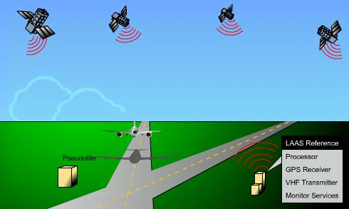 |
LAAS will yield the extremely high accuracy, availability, and integrity necessary for Category II/III precision approaches. It is fully expected that the end-state configuration will pinpoint the aircraft's position to within one meter or less and at a significant improvement in service flexibility, and user operating costs.
| ©AvStop Online Magazine Contact Us Return To News |