
Wide Area Augmentation System or WAAS
| The basic
GPS service fails to meet the accuracy (the difference between the
measured position at any given time to the actual or true position), availability
(the ability of a system to be used for navigation whenever it is needed
by the users, and its ability to provide that service throughout a flight
operation), and integrity (the ability of a system to provide timely
warnings to users or to shut itself down when it should not be used for
navigation) requirements critical to safety of flight.
In order to meet these requirements the FAA is developing the Wide Area Augmentation System or WAAS. WAAS is a safety-critical navigation system that will provide a quality of positioning information never before available to the aviation community. It is what the name implies, a geographically expansive augmentation to the basic GPS service. The WAAS improves the accuracy, integrity, and availability of the basic GPS signals. This system will allow GPS to be used as a primary means of navigation for enroute travel and non-precision approaches in the U.S., as well as for Category I approaches to selected airports throughout the nation. The wide area of coverage for this system includes the entire United States and some outlying areas such as Canada and Mexico. |
 |
||
|
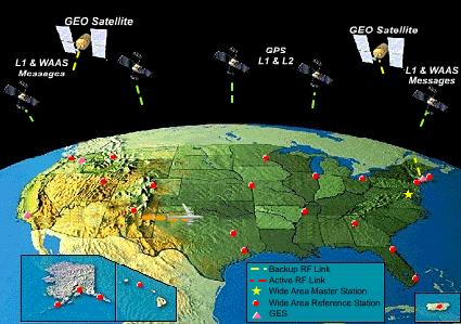
The
WAAS is based on a network of approximately 35 ground reference stations
that covers a very large service area. Signals from GPS satellites are
received by wide area ground reference stations (WRSs). Each of these precisely
surveyed reference stations receive GPS signals and determine if any errors
exist. These WRSs are linked to form the U.S. WAAS network. Each WRS in
the network relays the data to the wide area master station (WMS) where
correction information is computed.
The WMS calculates correction algorithms and assesses the integrity of the system. A correction message is prepared and uplinked to a GEO via a ground uplink system (GUS). The message is then broadcast on the same frequency as GPS (L1, 1575.42MHz) to receivers on board aircraft which are flying within the broadcast coverage area of the WAAS. The communications satellites also act as additional navigation satellites for the aircraft, thus, providing additional navigation signals for position determination. The WAAS will improve basic GPS accuracy to approximately 7 meters vertically and horizontally, improve system availability through the use of geostationary communication satellites (GEOs) carrying navigation payloads, and to provide important integrity information about the entire GPS constellation. |
|||
| ©AvStop Online Magazine Contact Us Return To News |