![]()
![]()
|
|
|
|
|
||||
| Scott Crossfield A Hispanic Pilot The First Pilot To Brake The Speed Record Of March 2 Dies In Plane Chash | ||||
|
|
On April 19, 2006, about 1110 (all times referenced are eastern daylight time), a Cessna 210A, N6579X, owned and piloted by a commercial pilot, crashed into remote mountainous terrain near Ludville, Georgia, after entering thunderstorms. The pilot, the sole occupant, was fatally injured. Instrument meteorological conditions prevailed at the time of the accident. The personal flight was operating under the provisions of 14 Code of Federal Regulations Part 91 while on an instrument flight rules (IFR) flight plan. The accident flight departed Prattville/Grouby Field Airport, Prattville, Alabama, about 1005, and was en route to Manassas Regional/Harry P. Davis Field Airport (HEF), Manassas, Virginia. The flight's planned route was over Rome, Georgia; Snowbird, Tennessee; Roanoke, Virginia; Montebello, Virginia; Casanova, Virginia; to HEF. |
|||
|
The pilot's requested cruise altitude was 11,000 feet mean sea level. After departure, the pilot contacted Montgomery air traffic control and was cleared to climb to 10,000 feet. About 1011, the accident airplane was handed off to Atlanta Air Route Traffic Control Center (ARTCC) sector 9. About 1018, the pilot checked in with Atlanta ARTCC and reported that he was climbing through 8,000 feet for 10,000 feet. The accident airplane was then cleared to 11,000 feet. About 1026, the pilot was told to contact Atlanta ARTCC sector 4 when the airplane was level at 11,000 feet. When the airplane reached 11,000 feet, the pilot contacted Atlanta ARTCC sector 4 and was given the local altimeter setting. |
||||
|
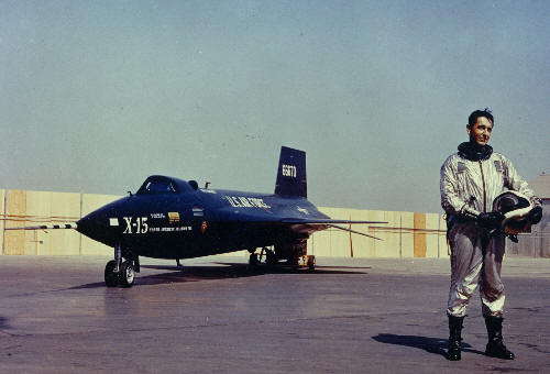
About 1038, another controller took over the sector 4 radar position, and the outgoing controller provided a position relief briefing. Included in that briefing was information about an area of severe weather north of Atlanta that was causing departing aircraft to deviate to the west instead of continuing northbound after takeoff. The briefing did not include specific references to the accident airplane. About 1045, the sector 4 controller told the pilot to contact Atlanta ARTCC sector 5. About 1046, the pilot checked in with the sector 5 controller and reported being level at 11,000 feet. The pilot was subsequently given two local altimeter settings. About 1100, the pilot was told to contact Atlanta ARTCC sector 38. The pilot checked in about 1101, stating that he was level at 11,000 feet. The pilot's initial call did not receive a response, so he repeated it, and the sector 38 controller provided the local altimeter setting. About 1109, the pilot transmitted, "Atlanta, this is seven niner x-ray I'd like to deviate south weather." The controller replied, "Six five seven niner x-ray roger we'll show you deviating south for weather and your mode C indicates one one thousand five hundred." The pilot did not respond. About 1110, radar contact was lost with the airplane at 5,500 feet. A plot of the aircraft radar track data indicated that the airplane entered a level 6 (extreme) thunderstorm before the loss of radar contact. Local law enforcement located the wreckage on April 20, 2006. The airplane impacted remote mountainous terrain about 3.3 nautical miles (nm) northwest of Ludville. According to Federal Aviation Administration (FAA) records, the pilot, age 84, held a commercial certificate with airplane single-engine land, multiengine land, and instrument airplane ratings. The pilot's multiengine airplane rating was limited to visual flight rules (VFR). The pilot's last aviation medical examination was completed on December 14, 2004, when he was issued a third-class medical certificate with the restriction "Must wear lenses for distance vision and possess glasses for near vision." On the pilot's application for his most recent medical certificate, he reported his total flight experience exceeded 9,000 hours. The pilot's logbook recovered at the accident site indicated that he had flown 95.5 hours during the previous 12 months, 28.5 hours during the prior 6 months, and 23.1 hours during the previous 30 days. During the prior year, all of the pilot's logged flights were in the accident airplane. The pilot's last flight review was competed on August 27, 2004. The pilot's logbook indicated that his total flight experience in actual instrument conditions was 423.1 hours and that an additional 106.0 hours were accumulated using a view-limiting device. The pilot logged 5.4 hours of instrument flight time and completed two instrument approaches during the previous 12 months. The pilot had not logged any instrument flight time or instrument approaches during the 6 months before the accident flight. According to the logbook, the pilot did not receive instrument instruction or complete an instrument proficiency flight within the previous 12 months. The pilot formerly was an aeronautical research pilot with the National Advisory Committee for Aeronautics (NACA) High-Speed Flight Station at Edwards Air Force Base, California. During his 5 years with NACA, he flew the X-1, XF-92, X-4, X-5, Douglas D-558-I Skystreak, and the Douglas D-558-II Skyrocket. On November 20, 1953, he became the first human to fly faster than twice the speed of sound in the Douglas D-558-II Skyrocket. From 1955 to 1960, he was employed by North American Aviation as the chief engineering test pilot during the development and testing of the X-15 rocketplane. The accident airplane was a 1960 Cessna 210A, serial number 21057579. The Cessna 210A was an all-metal airplane that incorporated a semimonocoque fuselage and empennage design. The airplane was equipped with externally braced wings, wing flaps, a constant speed propeller, and a retractable tricycle landing gear. The airplane was configured to seat four occupants and had a certified maximum takeoff weight of 2,900 pounds. Owned and operated by the accident pilot, the airplane was issued an FAA standard airworthiness certificate on December 6, 1960. The FAA issued the current aircraft registration certificate on December 11, 1989. The airplane (and its engine) had a total service time of 4,987.4 hours at the time of the accident. The last annual inspection was completed on March 19, 2006, and the airplane had accumulated 27.5 hours since the inspection. On March 22, 2006, tests on the static system, altimeter system, automatic pressure altitude reporting system, and transponder were completed. A review of the airframe maintenance records found no history of unresolved operational issues. The airplane was equipped with a 260-horsepower Teledyne Continental Motors IO-470-E engine, serial number 77583-0-E. The IO-470-E is a six-cylinder, horizontally opposed, 470 cubic inch displacement, fuel-injected, reciprocating engine. The engine had accumulated 1,259.8 hours since the last major overhaul. A review of the engine maintenance records found no history of unresolved operational issues. The propeller was a three-bladed McCauley D3A36C435/80VEA-0, hub serial number 042476. The propeller was installed on the accident engine on October 13, 2005. The airplane was equipped with a BFGoodrich WX 950 stormscope, a Garmin GNC 250 GPS/Com (global positioning system), and a Garmin GNS 430 GPS/Com/Nav. The GNC 250 was limited to VFR flight only. The Garmin GNS 430 system was approved for IFR domestic flight, including en route and non-precision approaches. On April 17, the airplane was topped off with 77.1 gallons of 100 low-lead aviation fuel at the departure airport. The accident occurred during the first flight after being refueled. At the time of the accident, the area forecast for northern Georgia expected an area of IFR to marginal VFR conditions during the morning hours, with isolated thunderstorms and moderate rain expected after 1000. These thunderstorms had a possibility of being severe, with cloud tops reaching 43,000 feet. About 0856, the National Weather Service (NWS) Storm Prediction Center described an ongoing cluster of strong to severe thunderstorms moving into northern Georgia, as a forward-propagating Mesoscale Convective System or squall line. The area was expected to further destabilize by midday because of surface heating, thus, enhancing the threat of organized severe thunderstorms and supercell thunderstorms. These thunderstorms had the high likelihood of producing hail, damaging high winds, and possible tornadoes. Imagery from Geostationary Operations Environmental Satellite number 12 depicted cumulonimbus clouds associated with the squall line. These clouds extended from extreme northeastern Alabama, across northern Georgia, southern Tennessee, and into western North and South Carolina. The accident site was located on the southern side of the system where cloud tops were near 37,000 feet. Higher cloud tops of 46,000 feet were observed to the west of the accident site and were associated with the observed squall line. According to aircraft radar track data, the accident airplane's last radar return was located under the anvil of a cumulonimbus cloud. The closest NWS Weather Surveillance Radar, WSR-88D, was located at the Peachtree City Airport, Atlanta, Georgia, approximately 70 miles south of the accident site. Based on radar height calculations, the 0.5-degree elevation scan depicted the weather conditions, which were encompassing altitudes between 4,400 to 11,460 feet over the accident site. The accident airplane's assigned cruise altitude was 11,000 feet. The base reflectivity images surrounding the accident airplane's flightpath indicated a large cluster of level 5 to 6 (intense to extreme) echoes moving southward across northern Georgia. These observed echoes intersected the airplane's recorded flightpath and were consistent with those of a heavy precipitation supercell thunderstorm. Between 1100 and 1115, the National Lightning Detection Network detected 55 cloud-to-ground lightning strikes within 15 statute miles (sm) of the accident site. The observed lightning strikes were clustered northwest to the north-northeast of the accident site and moved southward. No cloud-to-ground lightning strikes were detected within 5 sm of the accident airplane's position before the time of the accident. At the time of the accident, in-flight weather advisories were issued for severe thunderstorms over northern Georgia. Convective SIGMET 15E, issued about 1055, warned of an area of severe embedded thunderstorms over portions of Alabama, Georgia, Tennessee, and North Carolina. The thunderstorms were moving southward at 35 knots and had cloud tops reaching 45,000 feet. The thunderstorms had the potential for 2 inches of hail at the surface and aloft, wind gusts to 60 knots, severe to extreme turbulence, severe icing, localized IFR conditions, and microburst potential. Severe Weather Forecast Alert number 208, issued about 1100, warned of a line of strong to severe thunderstorms moving southward through an area that encompassed the accident site. The closest weather reporting facility to the accident site was at the Dalton Regional Airport (DNN), Dalton, Georgia, located about 16 miles northwest of the accident site. The airport was equipped with an automated surface observing system (ASOS). About 1118, the DNN ASOS reported: Wind 340 degrees true at 5 knots, gusting to 13 knots; visibility 3 sm in thunderstorm and heavy rain; scattered clouds at 800 feet above ground level (agl), broken ceiling at 4,800 feet agl, overcast ceiling at 8,000 feet agl; temperature 16 degrees Celsius; dew point 15 degrees Celsius; altimeter setting 29.94 inches of mercury. Remarks: Hourly precipitation 0.14 inches and lightning distant in all quadrants. The accident pilot obtained five Direct User Access Terminal weather briefings between April 18 and 19. The last briefing before departure was recorded on the morning of the accident about 0656. The pilot obtained weather-briefing material that included area forecasts, convective outlooks, weather watches, convective SIGMETs, airman's meteorological information (AIRMET), meteorological aviation routine weather reports (METAR), radar reports, terminal forecasts, and winds and temperature aloft data. Based on the information in the briefing, thunderstorms were forecast along the planned route of flight. Before departure, the pilot discussed the weather with an acquaintance and mentioned that he "might need to work his way around some weather, but it did not look serious." The pilot had an active weather account with XM Satellite Radio and subscribed to the basic weather package (XM Wx Aviator LT). According to XM Satellite Radio, no outages or interruptions of service were encountered on the day of the accident. XM Satellite Radio does not have the ability to track its product's location or to identify if and when a subscriber accesses or uses its weather products. The airplane was not modified with the required antenna and datalink receiver to display satellite weather information, according to airplane maintenance records and FAA documentation. The pilot was communicating with Atlanta ARTCC at the time of the accident. Transcripts of the voice communications between Atlanta ARTCC and the accident airplane are included with the docket material associated with this factual report. A review of Atlanta ARTCC communications with the accident airplane confirmed that the pilot was not provided any severe weather advisories nor was he advised of the radar-depicted weather displayed on the sector 38 radar controller's scope. According to recorded display system information, moderate to extreme weather was depicted along the accident airplane's flightpath. The airplane entered the depicted weather while at 11,000 feet, just before the pilot asked to deviate south because of weather. Radar contact was lost with the accident airplane at 5,500 feet, about 30 seconds after it initiated the turn to the south. When interviewed, the sector 38 radar controller acknowledged that adverse weather was present "all over" his sector with varying intensities. The controller stated that northbound departures out of Atlanta were encountering adverse weather and were "picking their way through holes in the weather." He acknowledged that controllers are required to issue known adverse weather to pilots. The controller also stated that his scope depicted adverse weather in the accident airplane's projected flightpath. The displayed weather included all three levels of precipitation (moderate, heavy, and extreme). The controller said that, even though adverse weather was throughout the area, he did not issue the information to the pilot because he felt that weather conditions displayed on his radarscope were unreliable. The controller believed that the displayed weather can be between 6 and 15 minutes old and is widely viewed as being unreliable. He stated that pilots have a better idea of where adverse weather is and that he expects them to inform him on what actions they need to take to avoid it. By not issuing weather reports to the pilot, the controller violated several paragraphs in FAA Order 7110.65, "Air Traffic Control." Paragraph 2-1-1, "ATC Service," of that order defines ATC's role. In part, the paragraph states: * The primary purpose of the ATC system is to prevent a collision between aircraft operating in the system and to organize and expedite the flow of traffic. * In addition to its primary function, the ATC system has the capability to provide (with certain limitations) additional services. * Controllers shall provide additional service procedures to the extent permitted by higher priority duties and other circumstances. The provision of additional services is not optional on the part of the controller, but rather is required when the work situation permits. Because controllers are required to divide their attention to a variety of tasks, FAA Order 7110.65 also explains how controllers should prioritize those tasks. Paragraph 2-1-2, "Duty Priority," states, in part, that controllers should: * Give first priority to separating aircraft and issuing safety alerts as required in this order. * Use good judgment when prioritizing all other provisions of this order, based on the requirements of the situation at hand. * First perform the action that is most critical from a safety standpoint. * Provide additional services to the extent possible, contingent only on higher priority duties and other factors, including limitations of radar, volume of traffic, frequency congestion, and workload. At the time of the accident, the Atlanta ARTCC sector 38 controller's workload consisted of the accident airplane and one other airplane. Review of sector 38 communications and radar data failed to identify any limitations of radar, excessive traffic, frequency congestions, or workload issues that would have prevented the controller from issuing pertinent weather information to the accident airplane. FAA Order 7110.65, paragraph 2-6-4, "Weather and Chaff Services," defines a controller's duties in the event of significant weather conditions. The paragraph states, in part: * Issue pertinent information on observed/reported weather or chaff areas. Provide radar navigation guidance and/or approve deviations around weather or chaff areas when requested by the pilot. * Issue weather and chaff information by defining the area of coverage in terms of azimuth (by referring the 12-hour clock) and distance from the aircraft or by indicating the general width of the area of coverage in terms of fixes or distance and direction from fixes. * Issue the level of echo intensity when that information is available. * When a deviation cannot be approved as requested and the situation permits, suggest an alternative course of action. * In areas of significant weather, plan ahead and be prepared to suggest, on the pilot's request, alternative routes/altitudes. * Weather significant to the safety of aircraft includes conditions, such as tornadoes, lines of thunderstorms, embedded thunderstorms, large hail, wind shear, microbursts, moderate to extreme turbulence (including clear air turbulence), and light to severe icing. FLIGHT RECORDERS The accident airplane was not equipped, nor was it required to be equipped, with a cockpit voice recorder or flight data recorder. WRECKAGE AND IMPACT INFORMATION The National Transportation Safety Board's on-scene investigation began on April 21, 2006. A GPS receiver was used to identify the position of the main wreckage as 34 degrees 30.767 minutes north latitude, 84 degrees 39.492 minutes west longitude. The main wreckage was located about 3.3 nm northwest of Ludville, in remote mountainous terrain. The GPS elevation of the accident site was 1,269 feet. The associated debris was located in two general areas, situated about 0.8 nm from each other. The overall wreckage distribution was consistent with a low altitude, in-flight breakup. The main wreckage was located in an impact crater that measured 4 1/2 feet deep and 6 feet wide. Damage to the dense overhead foliage was limited, consistent with a near vertical descent path. The main wreckage consisted of the cockpit, engine, propeller, left and right main wing spar assemblies, nose and main landing gear, left and right flap, and portions of the empennage. The second area of wreckage consisted of portions of the left and right wing leading edges, the upper portion of the vertical stabilizer leading edge and tip rib, a small section of right aileron skin, and the left cabin door. The wing tips, the majority of the left aileron, and the outboard portion of the right horizontal stabilizer and right elevator were not recovered. The major airframe structural components, engine, and recovered propeller blades were transported to a local Department of Transportation accident reconstruction yard. A layout of the wreckage confirmed that all major airframe structural components, except those that were not recovered (as previously noted), were accounted for. A majority of the airframe's primary structure exhibited severe impact damage and fragmentation. The lower firewall, cabin floor, and instrument panel were crushed upward and aft. Both wings were found in multiple sections. The observed wing damage was in various directions, and no definite failure direction was noted. All cable discontinuities in the flight control systems were consistent with tension overload or had been cut to facilitate wreckage recovery. The rudder, elevator, and elevator trim tab did not reveal any signs of overtravel. The flaps and landing gear were fully retracted as observed during the wreckage layout. Functional testing and disassembly of the wet vacuum pump showed no evidence of preimpact failure. No gyro instruments were found intact, and no detached gyros were found at the accident site. The engine remained attached to the airframe by only cables and wiring. Internal engine and valve train continuity was confirmed as the engine crankshaft was rotated. Compression and suction were noted on all cylinders in conjunction with crankshaft rotation. The right magneto was found separated from the engine and exhibited impact damage. The left magneto remained attached to the engine but was loose in its mounts. Both magneto drive gears were intact and undamaged. The ignition harness remained attached to the magnetos and exhibited multiple-point fraying throughout its length. The spark plugs were removed, and their electrodes exhibited normal wear. All cylinders were inspected with a lighted boroscope, and no discrepancies were noted. The engine-driven fuel pump rotated freely, and suction was confirmed. The fuel flow-divider was not recovered. Two of the three propeller blades were recovered, both of which exhibited chordwise scratches, blade twist, and leading edge damage. The on-scene investigation did not reveal any preimpact anomalies that would have prevented the normal operation of the airplane or its associated systems. MEDICAL AND PATHOLOGICAL INFORMATION On April 21, 2006, the Georgia Bureau of Investigation performed an autopsy on the pilot at its Northwestern Regional Crime Laboratory. Toxicology samples for the pilot were submitted to the FAA Civil Aeromedical Institute, Oklahoma City, Oklahoma. The toxicology report noted that the samples were received in a putrefied condition. The toxicology results indicated that ethanol was detected in liver and muscle samples, consistent with putrefaction. Quinine was detected in liver and kidney samples. |
| ©AvStop Online Magazine Contact Us Return To News |