
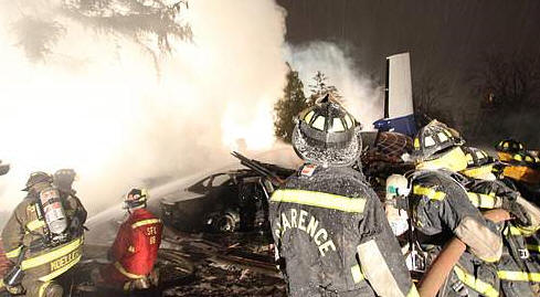
On October 19, 2004, about 1937 central daylight time, Corporate Airlines (doing business as American Connection) flight 5966, a BAE Systems BAE-J3201, N875JX, struck trees on final approach and crashed short of runway 36 at Kirksville Regional Airport (IRK), Kirksville, Missouri. The flight was operating under the provisions of 14 Code of Federal Regulations Part 121 as a scheduled passenger flight from Lambert-St. Louis International Airport, in St. Louis, Missouri, to IRK. The captain, first officer, and 11 of the 13 passengers were fatally injured, and 2 passengers received serious injuries.
The airplane was destroyed by impact and a postimpact fire. Night instrument meteorological conditions (IMC) prevailed at the time of the accident, and the flight operated on an instrument flight rules flight plan. The National Transportation Safety Board determined the probable cause(s) of this accident was the pilots' failure to follow established procedures and properly conduct a nonprecision instrument approach at night in IMC, including their descent below the minimum descent altitude (MDA) before required visual cues were available (which continued unmoderated until the airplane struck the trees) and their failure to adhere to the established division of duties between the flying and nonflying (monitoring) pilot.
Contributing to the accident was the pilots' failure to make standard callouts and the current Federal Aviation Regulations that allow pilots to descend below the MDA into a region in which safe obstacle clearance is not assured based upon seeing only the airport approach lights. The pilots' unprofessional behavior during the flight and their fatigue likely contributed to their degraded performance.
History: On October 19, 2004, about 1937 central daylight time,1 Corporate Airlines (doing business as American Connection)2 flight 5966, a BAE Systems BAE-J3201, N875JX, struck trees on final approach and crashed short of runway 36 at Kirksville Regional Airport (IRK), Kirksville, Missouri. The flight was operating under the provisions of 14 Code of Federal Regulations (CFR) Part 121 as a scheduled passenger flight from Lambert-St. Louis International Airport (STL), in St. Louis, Missouri, to IRK.3 The captain, first officer, and 11 of the 13 passengers were fatally injured, and 2 passengers received serious injuries.
The airplane was destroyed by impact and a postimpact fire. Night instrument meteorological conditions (IMC) prevailed for the flight, which operated on an instrument flight rules (IFR) flight plan. The flight crew was on a regularly scheduled 4-day sequence that began on Sunday, October 17, 2004. The accident occurred on the last flight of the third day, which departed from STL about 1842. Based on air traffic control (ATC) and cockpit voice recorder (CVR)4 information and Corporate Airlines dispatcher statements, the departure and en route phases of the accident flight were routine; the captain was the flying pilot and the first officer was the nonflying/monitoring pilot.5
When the flight was about 23 minutes from its destination, the pilots listened to the IRK automated surface observing system (ASOS) weather information, which indicated a wind from 040° at 6 knots, visibility 4 miles in mist, ceiling6 overcast at 300 feet above ground level (agl), temperature and dew point 9° Celsius (C), and an altimeter setting of 29.95 inches of mercury (Hg). After hearing the weather observation, the captain commented, “we’re not getting in...we don’t have an ILS [instrument landing system].”
The first officer responded, “I know…go all this [expletive] way. Well, let’s try it.” The captain responded, “yeah, we’ll try it.” About 30 seconds later, the captain said, “I don’t want to…go all the way out here for nothing tonight,” and moments later said, “I’ll be so happy when we have an ILS everywhere we go.” The first officer concurred, and the captain continued, “I thought we were gonna have it easy tonight.” According to ATC, radar, and CVR information, the flight was at 12,000 feet mean sea level (msl) and about 20 minutes from the destination airport when the Kansas City air route traffic control center (ARTCC) asked the pilots which approach they wanted into IRK. The pilots requested vectors for the localizer DME8 approach to runway 36 at IRK.
The controller acknowledged the pilots’ request and cleared them to descend from 12,000 to 8,000 feet msl “at pilot’s discretion.” The pilots acknowledged the clearance and began the descent checklist. The ARTCC controller advised the pilots to fly their present heading (which was about 300°) and to expect radar vectors for the localizer DME approach to runway 36. About 1920:06, the pilots again listened to the IRK ASOS weather information, which then indicated a wind from 040° at 5 knots, visibility 3 miles in mist, ceiling overcast at 300 feet agl, temperature and dew point 9° C, and an altimeter setting of 29.95 inches Hg. The first officer sighed, then stated, “it’s three miles and mist now,” and sighed again. The captain responded, “Really?…so it’s going down the tubes.”
Flight data recorder (FDR) data indicated that the airplane descended through 10,000 feet msl (bringing into effect sterile cockpit rules)9 about 1921:24. As the airplane further descended to 8,000 feet msl, the ARTCC controller cleared the pilots to descend at their discretion to and maintain 3,000 feet msl. The pilots acknowledged the clearance, and the captain briefed the approach,10 stating, “one eleven point five, three fifty seven’s the inbound. Twenty five hundred at KEMMY.[11] Thirteen twenty is our MDA [12], and we have a three hundred sixty foot approach set in the radar altimeter…nine sixty six for the airport elevation, nine sixty four is the touchdown zone elevation [TDZE]. Speeds as previously briefed, fifteen, twenty one, and thirty. If we have to go missed we’ll set max power, flaps ten, positive rate, gear up…and we’ll climb to three thousand feet then direct Kirksville VOR,[13] and hold.”
As the airplane began to descend into the top of the clouds, the CVR recorded the captain stating, “…we’re going into the crap. Look, ooh, it’s so eerie and creepy…get a suffocating feeling when I see that.” The first officer made a barking sound followed by a groan, and, about 1925:13, the captain continued, stating, “I’m drowning…,”14 then he remarked, “MSA[15] is thirty one hundred.” The first officer responded, “correcto mundo.” About 25 seconds later, CVR recorded a yawn on the first officer’s channel,16 then he stated, “they have a VASI [visual approach slope indicator] on the left hand side,” and the captain responded, “yeah. Wish we had an ILS on the front side.” The first officer said, “yeah, that’d be nice.”
When the airplane was about 10 minutes from its destination, the ARTCC controller advised the pilots to turn 10° to the right to intercept the localizer for runway 36 at IRK. The pilots complied, turning to a heading of 310.° About 2 minutes later, the captain asked, “how’s…Kirksville looking weather wise? Getting any worse?” The pilots again listened to the IRK ASOS weather information, which indicated a wind from 030° at 6 knots, visibility 3 miles in mist, ceiling overcast at 300 feet agl, temperature and dew point 9° C, and an altimeter setting of 29.95 inches Hg. The captain stated, “temp [and] dew point’s right where you don’t want it,” and the first officer responded, “yeah…still three hundred.”
The pilots performed the approach checklist as the airplane descended and leveled off at 3,100 feet msl. About 1930:35, the ARTCC controller told the pilots they were 11 miles south of the final approach fix (FAF) for the localizer DME approach to runway 36 at IRK. He advised them to turn right to a heading of 330° and maintain an altitude of 3,000 feet msl until they were established on the localizer, then cleared them for the localizer DME approach to runway 36 at IRK. The pilots complied and the first officer advised the captain that the localizer course was “alive.”17 The captain stated, “Let’s go flaps ten and we’ll configure early…give ourselves as much time as we can.” The first officer agreed and selected and verified 10° of flaps as the airplane intercepted the final approach course.
Less than 1 minute later, the captain confirmed with the first officer that they could descend to 2,500 feet msl at that point in the approach, then asked the first officer to extend the landing gear, select 20° of flaps, and perform the before landing checklist. About 1932:48, the first officer stated, “gear down…flaps selected indicating twenty” and continued the before landing checklist. About 1933:40, the ARTCC controller approved a frequency change (to the IRK common traffic advisory frequency [CTAF]) and advised the pilots to report after they landed. The first officer acknowledged the instructions and, at the captain’s request, keyed the microphone to activate the pilot-controlled runway lights at IRK.18 According to FDR, CVR, and radar data, the airplane was at 2,500 feet msl when it crossed the FAF at 19:35:36, and the first officer advised the captain that they could descend to 1,320 feet msl, the MDA for the approach. The captain acknowledged, stating, “thirteen twenty, here we go.” Radar and calculated FDR data indicated that the airplane then began to descend about 1,200 feet per minute (fpm) while tracking the localizer.
About 1936:23, as the airplane descended through about 1,600 feet msl, the first officer stated, “five hundred, four hundred to go.” About 17 seconds later (at 1936:30.6), as the airplane descended through about 1,450 feet msl (about 500 feet agl), the CVR recorded the airplane’s ground proximity warning system’s (GPWS) mechanical announcement, “five hundred.”
At 1936:33.9, as the airplane descended through about 1,380 feet msl, the first officer stated “thirteen twenty.” The captain thanked him and about 3 seconds later (as the airplane reached the MDA), stated, “I can see ground there.”19 As he finished speaking, the GPWS annunciated, “minimums, minimums,” indicating that the airplane had reached 1,320 feet msl. Calculated FDR data indicated that the airplane continued to descend at a rate of about 1,200 fpm. At 1936:40.5, the captain asked, “what do you think?,” and the first officer responded, “I can’t see [expletive].” About 2 seconds later, as the airplane continued to descend, the captain stated, “yeah, oh there it is. Approach lights in sight.” Almost immediately, the GPWS annunciated “two hundred” feet agl and the first officer stated, “…in sight…continue.” The airplane was descending through about 1,160 feet msl (160 feet below the MDA) at this time.
As the pilots continued the approach, still descending about 1,200 fpm, the first officer asked the captain if he wanted the flaps extended to 35.° At 1936:52.2, the captain responded, “no,” and the GPWS began to announce, “sink rate.”20 One second later, the first officer exclaimed, “trees,” and the captain stated, “no, stop.” The first sounds of impact with the trees were recorded at 1936:55.2, and numerous sounds of impact were recorded before the CVR stopped recording at 1936:57.5.
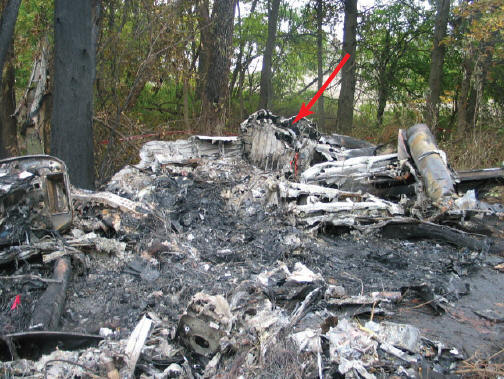
FDR and radar data and the National Transportation Safety Board’s airplane performance study21 indicated that the airplane maintained a relatively constant heading and flightpath angle during the descent from the FAF until the pilots saw the trees immediately before the initial impact occurred. At that time, the Safety Board’s performance study indicated a reduction in the airplane’s descent rate and increases in airplane nose up elevator movement and vertical acceleration. Physical evidence showed that the airplane first contacted the trees more than 1.3 nautical mile (nm) south of the approach end of runway 36, about 50 feet agl (about 996 msl), and continued descending through trees toward the runway. The airplane came to rest with the forward fuselage aligned on about a 190° heading and the aft fuselage on about a 240° heading. The main wreckage site was located about 775 feet north of the initial impact site and about 1.2 nm south of the approach end of runway 36.