 |
|
|
|
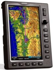
Garmin GPSMAP 696, A Big Screen Portable Aviation Navigator with U.S. Charts OLATHE, Kan. October 30, 2008, Business Wire — Garmin International Inc., a unit of Garmin Ltd. (NASDAQ: GRMN), the global leader in satellite navigation, announced today the GPSMAP® 695 and GPSMAP 696, a new series of portable aviation navigation devices. As Garmin’s new flagship portable aviation product, the GPSMAP 696 incorporates the popular aviation features of the GPSMAP 496 while also adding new capabilities such as airways, electronic charts and expanded weather. In addition, the GPSMAP 696’s information is displayed on a screen that is three times larger than the GPSMAP 496. The GPSMAP 696 will be on display and available for purchase at the Aircraft Owner and Pilot’s Association (AOPA) Expo in San Jose, California, November 6-8, 2008. “The GPSMAP 696 gives pilots exactly what they have been looking for, a GPS with a large screen, electronic charts and real-time weather,” said Gary Kelley, Garmin’s vice president of marketing. “It’s our most feature rich, easy-to-use aviation portable, and is ideal for those wanting to minimize flipping through paper charts while in the cockpit.” The GPSMAP 696 is an all new, tablet-style device with a large, 7-inch portrait screen that makes it possible to view an entire approach plate on the display. The high-resolution, sunlight readable screen uses Garmin’s latest technology to ensure that pilots will be able to read the vibrant display day or night. The bezel that frames the bright screen has multiple keys on the bottom and right sides. |
|
|
|
The soft keys at the bottom of the display control the most commonly used features of the current page, such as turning the weather display on/off. The dedicated keys on the display’s right side have specific functions such as nearest, direct to, flight plan, zoom in/out and menu. Also on the display’s right side is a rotary knob/joystick, similar to the G1000’s joystick, that lets pilots enter airport identifiers, pan the map, or scroll to page and sub-page groups. Thanks to the GPSMAP 696’s IFR map mode, Part 91 pilots may be tempted to leave their IFR enroute paper charts at home. This mode displays a map similar to a standard enroute chart that has important features like victor airways, jet routes, minimum enroute altitude (MEA) and leg distance. The 696’s IFR map mode also offers more situational awareness than traditional charts because it subtlety displays major visual reference points like rivers, state boundaries, highways and railroad tracks from Garmin’s built-in basemap. The GPSMAP 696 also includes Garmin FliteCharts, an electronic version of the National Aeronautical Chart Office (NACO) U.S. Terminal Procedures Publication. With FliteCharts, pilots can quickly find and view all NACO departure procedures (DP), standard terminal arrival routes (STARs), approach charts and airport diagrams. If the current approach is known, the GPSMAP 696 automatically selects the correct chart based on the flight plan. FliteCharts are available every 28-days and will not be available on the 696 if they are not updated regularly. The GPSMAP 696 may be used in lieu of paper approach charts when used in accordance with AC 91-78. As with several other Garmin portable devices, the GPSMAP 696 has a receiver for XM radio and XM WX Satellite Weather (U.S. customers only) that gives next generation radar (NEXRAD), aviation routine weather reports (METARs), terminal aerodrome forecasts (TAFs), temporary flight restrictions (TFRs), lightning, winds aloft, turbulence forecasts, and several other important weather products. The 696 is also Garmin’s first portable device with PIREPs and icing forecast information. The weather data may be laid directly over the unit’s navigation and topographic map databases. Weather and radio information is delivered to the 696 via Garmin’s new GXM™ 40 smart antenna, which is included with the GPSMAP 696. XM WX subscription data is available from XM WX Satellite Weather. Other popular features found on the GPSMAP 696 include Smart Airspace, SafeTaxi and AOPA Airport Directory data. During flight, Garmin’s Smart Airspace automatically highlights airspace close to the pilot’s current altitude and de-emphasizes airspace away from the current altitude, which ultimately aids in situational awareness. Thanks to SafeTaxi, taxiing at unfamiliar airports is also easier because the GPSMAP 696 includes geo-referenced diagrams of over 850 U.S. airports that identify runways, taxiways and hangars, as well as the aircraft’s exact location on the field. The AOPA Airport Directory data is an electronic version of AOPA’s popular U.S. pilot guide that includes information for over 5,300 public-use airports and more than 7,000 FBOs, such as pilot services, ground transportation, lodging, restaurants, and local attractions. In addition, Garmin’s electronic version of the AOPA Airport Directory highlights airports where pilots can save on fuel by using self-service fueling locations. Pilots can keep track of and renew the databases on their GPSMAP 696 through fly.Garmin.com, a website that helps pilots manage Garmin database information and dramatically simplifies the process of updating and purchasing aviation databases. Fly.Garmin.com monitors the device’s terrain, FliteCharts, SafeTaxi, AOPA airport directory and obstacle databases. After logging onto fly.Garmin.com, the home page gives a quick synopsis of the owner’s registered products and whether or not the databases are current. If a database needs to be updated, users can purchase one-time downloads or annual subscriptions directly from the site and install the database in three easy steps. Fly.Garmin.com eliminates the hassle of “unlock codes.” North American customers that do not require XM radio and XM WX Satellite Weather, may be interested in the GPSMAP 695 Americas that has identical features to the GPSMAP 696 except that it does not include the GXM 40 smart antenna and may not be upgraded to add XM datalink capability in the future. Garmin also offers a GPSMAP 695 Atlantic and GPSMAP 695 Pacific version for customers in Europe and Australasia, respectively. The GPSMAP 695 Atlantic is pre-loaded with VFR reporting points (VRPs), private airports, and obstacles. The GPSMAP 695 Atlantic and Pacific do not include XM capability, AOPA Airport Directory, FliteCharts or SafeTaxi diagrams. The GPSMAP 695 and 696 are available immediately for an expected street price of $2,695 and $3,295, respectively. The GPSMAP 696 package includes a yoke mount, GXM 40 smart antenna, cigarette-lighter adapter, AC adapter cable, USB-to-PC interface cable, low-profile remote GPS antenna, unit cover, free Jeppesen update certificate, owner’s manual and quick-reference guide. |
||
| ©AvStop Online Magazine To Advertise With Us Contact Us Return To News | ||