
NEWSROOM
![]()
![]()
|
|
NEWSROOM |
|
|
|
||||
|
Garmin
Brings Touchscreen And Widescreens To The Cockpit By Daniel Baxter |
||||
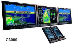 |
October 22, 2009, Orlando, Fla. Garmin International Inc., announced the Garmin G3000, the first touchscreen controlled integrated flightdeck for light turbine aircraft. The G3000 is designed specifically for Part 23 turbine aircraft, and was announced at the National Business Aviation Association Convention. “In 2003, we transformed the general aviation cockpit with the G1000, and now we’re taking the next leap forward with the G3000,” said Gary Kelley, Garmin’s vice president of marketing. “The G3000 is a testament to the culture of innovation that is fundamental to Garmin, and it promises to be one of the most intuitive and powerful flightdeck systems ever designed for Part 23 turbine aircraft.” The G3000 seamlessly integrates numerous Garmin-designed system components into an easy-to-use flightdeck. |
|||
|
The G3000 incorporates the all new GTC 570 vehicle management system, a 5.7-inch diagonal touchscreen controller that uses a desktop-like menu interface with intuitive icons. The console-mounted GTC 570 allows for full control for radio management, audio management, flight management, weather systems management, synoptics, and other vehicle systems. The simplistic user interface leverages the experience Garmin has gained by designing and delivering millions of automotive consumer products, and it eliminates buttons, switches, and extraneous knobs. The touchscreen also enhances ease of use through common sense functions like “back” and “home” that let pilots quickly retrace their steps or return to the home screen. The GTC 570 vehicle management system also uses patent pending, infrared touchscreen technology, audio and visual feedback, and animation to help pilots know exactly how the system is responding to their input. “We’ve gone to great lengths to make the G3000 simple to operate,” said Kelley. “For example, with the GTC 570, pilots touch the information they want to change rather than using a cursor. This intuitive approach makes it easy to enter the information right the first time, and helps decrease pilot workload.” The GTC 570 also incorporates three conventional knobs at the bottom of the display: a volume control knob, dedicated map joystick and dual concentric knob for data entry. Pilots may choose to use the knobs instead of the touchscreen to enter information and the knobs’ functions are always labeled on the display. Extra-wide, split-screen displays, the primary flight displays (PFD) and multi-function display (MFD) are 14.1-inch diagonal WXGA high resolution wide aspect ratio displays. The large landscape oriented displays make it possible to have an enhanced view of Synthetic Vision Technology (SVT™) that displays three dimensional terrain, obstacles, pathways, and traffic. Situational awareness is enhanced further with a large inset map, and an extended horizon line. |
||||
|
The G3000’s large MFD also has split-screen capability so that two separate vertical pages may be viewed side-by-side. Pilots may simultaneously view maps, charts, TAWS, flight planning, weather or video input pages. In addition, aircraft synoptics can be graphically depicted on the MFD to help simplify monitoring and speed troubleshooting. As with the G1000®, the G3000 has full reversionary capabilities, including in-flight dynamic restarts, so that all flight critical data can be transferred seamlessly to a single display for added safety during flight. The G3000 also includes a fully capable three-axis, fully digital, dual channel, fail passive auto flight system. The autopilot includes features you would expect in this class of aircraft such as coupled wide area augmentation system (WAAS) approaches, vertical navigation, and flight level change (FLC). On the G3000’s widescreens, Garmin’s SVT presents near life-like 3D depictions of terrain, obstacles, traffic and the runway environment so that the image on the display replicates what pilots would see outside the cockpit on a clear day. SVT works seamlessly to alert pilots of potential ground hazards by displaying terrain and obstacles which pose a threat to the aircraft with appropriate TAWS alert coloring, as well as voice alerts. SVT also includes pathways (or Highway-In-The-Sky) that are depicted as 3D “flying rectangles” and help pilots stay on course when flying en route legs, VNAV legs, GPS/WAAS vertical approach procedures, ILS approach procedures, and arrival and departure procedures. The G3000 avionics suite also integrates synoptics (graphical systems displays), Garmin’s SafeTaxi®, FliteCharts® and ChartView (optional), which simplify operation, enhance situational awareness, and increase safety during flight and when taxiing. Garmin SafeTaxi includes over 950 U.S. airports and helps pilots navigate unfamiliar airports while taxiing by identifying runways, taxiways, runway incursion hotspots, and hangars, as well as the aircraft’s exact location on the field. FliteCharts is an electronic version of the AeroNav Charts (formerly known as the NACO U.S. Terminal Procedures Publication) and lets pilots quickly find and view all Departure Procedures (DP), Standard Terminal Arrival Routes (STARs), approach charts, and airport diagrams on the MFD. Garmin ChartView is an electronic version of Jeppesen’s extensive library of charts and airport diagrams displayed directly on the G3000’s MFD. Garmin expects to receive G3000 Technical Standard Orders (TSO) certification in the second half of 2011. |
| ©AvStop Online Magazine Contact Us Return To News |
