
| NEWSROOM |
|
|
![]()
![]()
|
|
|
|
|
|
|
|||
|
By Daniel Guevarra |
||||
 |
February 20, 2010
- NOAA's National Weather Service will use a new hurricane scale this
season called the Saffir-Simpson Hurricane Wind Scale. The scale keeps
the same wind speed ranges as the original Saffir-Simpson Scale for each
of the five hurricane categories, but no longer ties specific storm
surge and flooding effects to each category.
Herbert Saffir, a consulting engineer, and Robert Simpson, who was director of the National Hurricane Center from 1967 through 1973, developed the original scale which was a useful tool to convey the threats of tropical cyclones. Changes were made to the Saffir-Simpson Scale because storm surge values and associated flooding are dependent on a combination of the storm’s intensity, size, motion and barometric pressure, as well as the depth of the near-shore waters and local topographical features. As a result, storm surge values can be significantly outside the ranges suggested in the original scale.
For example,
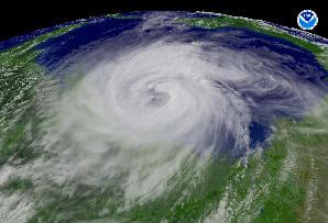
Hurricane Ike in 2008 was a very large storm that made landfall on the
upper
Storm surge
forecasts will continue to be included in hurricane advisories and
statements issued by the |
|||
| Hurricane Ike bears down onto the upper Texas coastline with category 2 wind speed of 110 mph, September, 2008 | ||||
 |
||||
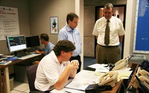
| Senior Hurricane Specialist Jack Beven discusses the forecast track of Hurricane Bill with hurricane specialist unit branch chief James Franklin and NHC director Bill Read | ||||
|
The decision to implement the Saffir-Simpson Hurricane Wind Scale was based, in part, on an assessment of the responses received during a 2009 public comment period. The descriptions of wind impacts in the new scale were updated with assistance from highly respected wind scientists from academia and industry.
"I applaud the
NOAA decision to decouple storm surge predictions from the Saffir-Simpson
scale,” said Al Goodman, Floodplain Management Bureau director,
Mississippi Emergency Management Agency. Goodman noted that while
Hurricane Katrina hit the NOAA understands and predicts changes in the Earth's environment, from the depths of the ocean to the surface of the sun, and conserves and manages our coastal and marine resources. The National Oceanic and Atmospheric Administration is a scientific agency within the United States Department of Commerce focused on the conditions of the oceans and the atmosphere. NOAA warns of dangerous weather, charts seas and skies, guides the use and protection of ocean and coastal resources, and conducts research to improve understanding and stewardship of the environment. |
| ©AvStop
Online Magazine
Contact
Us
Return To News
|
|
