1. INTRODUCTION.
It is imperative for all pilots planning an oceanic flight to become familiar with the appropriate Federal Aviation Regulations (FAR) and the information contained in Notices to Airmen (NOTAM), International Flight Information Manual (IFIM), Aeronautical Information Publication (AIP), International Civil Aviation Organization (ICAO) Annexes, and regulations of the foreign countries over which they intend to fly. In addition, customs procedures, cultural considerations, entry and overflight procedures, and immunization requirements must be considered. Pertinent FAR for various flight configurations are listed in this Advisory Circular (AC). Other referenced documents are listed in Appendix 3, with information on their contents and publishers.
a. Legal Basis for International Operations. During oceanic flights, pilots must adhere to the U.S. regulations, ICAO regulations, and the regulations of the nations that they overfly or in which they land. This requirement is based upon the Convention on International Civil Aviation, commonly known as the Chicago Convention. The General Principles and Application of the Convention were signed by the United States on December 7, 1944, ratified on August 9, 1946, and became effective on April 4, 1947 (see Chapter 1). This document defined numerous aspects of international operations. Flight regulations for oceanic operations are specifically covered in Annex 2, "Rules of the Air." FAR 91.703 ensures that the Rules of the Air are binding to operators of U.S. registered aircraft operating outside of the United States, and it is the FAA's responsibility to ensure that pilots of U.S. registered aircraft comply with these regulations.
b. Information Sources. Member states follow ICAO guidelines by publishing statistical aeronautical information in the AIP for a flight information region (FIR). The AIP is the state's official publication that defines and describes the airspace, aeronautical facilities and services, and national rules and practices pertaining to air traffic. AIP's are available through the aviation departments of the publishing country. AIPs for each FIR to be flown over should be consulted during the planning of any international flight. Some ICAO member states jointly produce and publish AIP information in a single volume. Others do not publish AIP information in book form, but issue AIP information through NOTAMs. It is imperative that pilots and/or flight departments consult NOTAMs to determine if changes to published data have occurred. International NOTAM information is available from the U.S. International NOTAM office or through local flight service stations (FSS).
c. Precautions. Operators are advised to ensure full compliance with
each country's requirements in advance. This ensures that all flights into,
from, or over foreign territories comply with that territory's regulations.
Particular attention should be given to the permissibility of night flights
and operations between sunset and sunrise. The hours during which customs,
immigration, and other services are operational should also be considered.
Information on a country's normal work week may be obtained from the U.S.
Embassy. All countries require some form of advance notification of arrival.
If a number of days or hours advance notice is not specified, notification
should be sent far enough in advance to permit processing and response.
Pilots should carry a copy of the advance notification as well as confirmation
that the notification was sent. This is particularly important for countries
that do not normally return request approvals. Operators should ensure
that all required entry documents are available for presentation upon arrival.
Multiple copies may be needed of documents such as ownership papers, general
declarations, passenger and cargo manifests, licenses, crewmember certificates,
logbooks, and radio licenses. Availability, types, and duration of visas,
tourist cards, and other entry documents should be determined before departure.
Some countries require that a traveler have a visa for the next country
of entry before departure, as well as proof of required immunizations for
that country. This information can be obtained from the U.S. Embassy. Aircraft
that will remain within the territorial limits of a country for an extended
period of time may become subject to import regulations and may be impounded.
Operators should determine in advance the number of days that an aircraft
may remain in any country where the aircraft will land.
2. FEDERAL AVIATION REGULATIONS PERTINENT TO INTERNATIONAL OPERATIONS.
This section lists specific FAR that are pertinent to international operations. This listing is a compilation of FAR that have particular importance in international operations. Crews are advised to reference these FAR prior to planning an oceanic or international flight. This listing of FAR is for guidance only, and does not eliminate or provide relief from other FAR that are not listed. Pilots transporting aircraft internationally should also be aware of the contents of Chapter III, "Nationality for Aircraft," in the agreements of the Chicago Convention.
FAR PART 45 - IDENTIFICATION AND REGISTRATION MARKING
---------
Key:
A - SUBJECT
B - FAR
--------
A - Nationality and Registration Marks - General
B - Sec. 45.21
A - Display of Registration Marks - General
B - Sec. 45.23
A - Size of Registration Marks
B - Sec. 45.29
A - Marking of Export Aircraft
B - Sec. 45.31
FAR PART 47 - AIRCRAFT REGISTRATION
------------
Key:
A - SUBJECT
B - FAR
------------
A - Registration required
B - Sec. 47.3
A - Applicants for Aircraft Registration
B - Sec. 47.5
A - * Certification of U.S. Citizenship
B - Sec. 47.7
A - * Voting Trust
B - Sec. 47.8
A - * Corporation not U.S. citizen
B - Sec. 47.9
A - Evidence of Ownership
B - Sec. 47.11
A - Effective Date of Aircraft Registration
B - Sec. 47.39
A - Invalid registration
B - Sec. 47.43
A - Cancellation of Certificate for Export
B - Sec. 47.47
* These regulations are especially noteworthy in regard to international operations. They each contain citizenship requirements relative to the legality of an aircraft registration and will be checked by inspectors upon application for any required Letter of Authorization (LOA).
FAR PART 91 - GENERAL OPERATION AND FLIGHT RULES
---------
Key:
A - SUBJECT
B - FAR
---------
A - Survival Equipment for Overwater Operations
B - Sec. 91.509
A - Radio Equipment for Overwater Operations
B - Sec. 91.511
A - Operation of Civil Aircraft of U.S. Registry Outside of the United
States
B - Sec. 91.703
A - Operations Within the North Atlantic Minimum Navigation Performance
Specifications Airspace
B - Sec. 91.705
A - Flights Between Mexico or Canada and the United States
B - Sec. 91.707
A - Operations to Cuba
B - Sec. 91.709
FAR PART 135 - AIR TAXI OPERATIONS AND COMMERCIAL OPERATORS
----------
Key:
A - SUBJECT
B - FAR
----------
A - Crewmember Certificate, International Operations: Application and
Issue
B - Sec. 135.43
A - Aircraft Proving Tests
B - Sec. 135.145
A - Radio and Navigation Equipment: Extended Overwater or IFR Operations
B - Sec. 135.165
A - Emergency Equipment: Extended Overwater Operations
B - Sec. 135.167
A - Performance Requirements: Land Aircraft Operated Overwater
B - Sec. 135.183
FAR PART 121 - COMMERCIAL OPERATORS
------------
Key:
A - SUBJECT
B - FAR
------------
A - Rules Applicable to Operations in a Foreign Country
B - Sec. 121.11
A - Enroute Navigation Facilities
B - Sec. 121.121
A - Emergency Equipment for Extended Overwater Operations
B - Sec. 121.339
A - Radio Equipment for Extended Overwater Operations and Certain Other
Operations
B - Sec. 121.351
A - Emergency Equipment for Operations Over Uninhabited Terrain Areas
B - Sec. 121.353
A - Doppler Radar and Inertial Navigation Systems
B - Appendix G
FAR PART 125 - CERTIFICATION AND OPERATION OF AIRPLANES HAVING A SEATING CAPACITY OF 20 OR MORE PASSENGERS OR A MAXIMUM PAYLOAD CAPACITY OF 6,000 POUNDS OR MORE
--------
Key:
A - SUBJECT
B - FAR
--------
A - Emergency Equipment: Extended Overwater Operations
B - Sec. 125.209
A - Flight Release Overwater
B - Sec. 125.363
3. PLANNING.
Adequate planning is the key to a successful international flight, whether it be an airline or a single engine light aircraft. The lead time required for planning varies with the experience and training background of the crew and the amount of assistance available from a company dispatcher or a planning agency. Planning can never start too early and should always be done within 30 days lead time if at all possible. Experienced crews flying the same route on a regular basis can reduce planning time significantly, but a new crew or a crew flying a new route should adhere to the 30 days rule of thumb.
Many crews utilize flight planning agencies for flight planning. While most agencies do an excellent job, planning agencies only provide the information that is requested, and they are not responsible for errors. The pilot in command (PIC) is ultimately responsible for the operation of the aircraft. Although an error may be caused by a planning agency, the PIC is still the responsible party. Some crews prefer to do their own planning, or do so for economic reasons. The following information is provided to assist in planning an oceanic operation.
a. Preflight Considerations. Pilots planning international flights should complete the following tasks:
(1) Research the IFIM.
(2) Arrange handling if the flight will be landing in several countries. This is extremely important if there are multiple passengers on the aircraft.
(3) Arrange hotel and ground transportation ahead of time. It is prudent to ensure that the correct grade of fuel is available at the planned arrival points.
(4) Prepare flight plan/logs and ICAO flight plans (see Appendix 1).
(5) Obtain and complete the required documents:
* general declarations.
* passenger/cargo manifests.
* passengers passports, visas (if required), and health cards.
* crew lists with certificate information, medical data and passport number. Ensure that the crew has all of the paperwork required of the passengers plus their pilot and medical certificates.
(6) Contact Customs as required.
(7) Complete the checklist and carefully review each of the items to ensure that all items are complete. A sample checklist is included at the end of this Chapter.
b. Itinerary Preparation. Preparing the itinerary is one of the most important aspects of an international flight. Experienced international pilots have often observed that the most difficult, but important, part of an international flight takes place before the aircraft departs. This paragraph presents some questions that a preflight planner must consider:
(1) What is the destination of the flight?
* Is an alternate destination available within range of the aircraft?
* Is lodging available at the destination?
* Is the appropriate grade of fuel available?
* Is a landing permit required at the destination?
* Is a visa required at the destination? Is cabotage allowed?
* Does a State Department warning exist for health, security, or other precautions?
* Are maintenance services available at the destination airport? Should spare parts be carried?
(2) Enroute airports - use the same guidelines as for the destination airport.
(3) Distance between stops - how was navigation distance determined?
* International Air Traffic Association (IATA) Distance Manual.
* globe.
* chart measurement.
* long range navigation system.
* computer flight planning service.
* other.
(4) Equal time point (ETP) considerations:
* pressurization ETP where an altitude change is mandated.
* loss of engine ETP in a multiengined aircraft.
* combined problem (pressurization and loss of engine).
(5) Ground time at airports:
* passenger requirements.
* turnaround capacity.
* crew rest requirements, if applicable.
* next stop arrival time.
(6) Time considerations:
* local time.
* UTC (Zulu) or Greenwich time.
* local time at departure airport.
c. The International Notice to Airmen (IN). The IN is a biweekly compilation of significant international information and special notices which could affect a pilot's decision to enter or use certain areas of foreign or international airspace. Of crucial importance to those seeking to enter potentially dangerous areas of the world, this publication complements and expands upon data contained in the IFIM. The distribution of U.S. international NOTAMs to foreign international NOTAM offices (NOF) and the receipt and distribution of foreign international NOTAMs are accomplished by the U.S. International NOTAM Office (U.S. NOF), a part of the National Flight Data Center (NFDC) in Washington, DC.
NOFs exchange Class I NOTAMs with the other NOFs via the Aeronautical Fixed Telecommunication Network (AFTN). Class I NOTAMs are distributed via telecommunication; Class II NOTAMs are delivered via the U.S. Postal Service. NOTAMs from foreign NOFs are received via AFTN at the FAA National Communication Center in Kansas City, Missouri and relayed to the U.S. NOF in Washington, DC. The U.S. NOF receives all incoming Class I NOTAMs for processing and automatic distribution to U.S. aviation users.
The U.S. NOF reviews all Class I NOTAMs received to ensure their completeness, for conversion into English plain text, and for distribution to aviation users in the conterminous United States, Alaska, Hawaii, and Puerto Rico. Upon distribution, all Class I NOTAMs are simultaneously entered into a computerized International NOTAM file at the National Communication Center in Kansas City according to both NOTAM number and location. Computer storage of Class I international NOTAM information allows the NOTAMs to be made available for instant recall by all FSSs and AFTN subscribers through the request-reply feature of the Service B and AFTN telecommunication networks.
Only current Class I NOTAMs are available by request-reply on Service B and AFTN. The Kansas City computerized NOTAM file may be queried for a list of all NOTAMs by geographic location or for a single NOTAM number (airspace NOTAMs are filed under the issuing NOF).
The United States does not exchange Class I international NOTAMs with all foreign international NOFs. A complete tabulation of international NOTAM exchanges among international NOFs and the areas of responsibility for each NOF is contained in Appendix 1 of this AC.
d. International Flight Plans. Flight plans are required for all flights
into international and foreign airspace. The standard flight plan form
is FAA Form 7233-4, "International Flight Plans," available at most U.S.
Flight Service Stations. (A blank copy of this form is contained in Appendix
1). The FAA complies with the ICAO Format, except that it does not
accept cruising speed/level in metric terms. (See Appendix
1 of this circular for conversion of U.S. measurements to metric measurements.)
Flight plans must be transmitted to, and should be received by, air traffic
control (ATC) authorities in each ATC region to be entered at least 2 hours
prior to entry, unless otherwise required by an enroute or destination
country. When filing flight plans in countries outside the United States,
it is extremely important that inquiries be made by the pilot as to the
method used for subsequent transmission of flight plan information to enroute
and destination points and of the approximate total elapsed time applicable
to such transmissions.
The flight plan provides advance notice of foreign airspace penetration and facilitates effective ATC procedures. For some countries, the flight plan is the only advance notice required; other countries use the flight plan as a check against previously granted permission to enter national airspace. Acceptance of a flight plan and issuance of a flight clearance by a foreign ATC unit does not constitute official approval for airspace penetration if prior permission for airspace penetration is required by civil aviation authorities and such permission has not been previously secured. Airspace violations that occur in such instances are pursued, and inflight interception may result.
In the case of flights outside of U.S. airspace, it is particularly important for pilots to leave a complete itinerary and flight schedule with a responsible person. That person should be kept apprised of the flight's progress and instructed to contact an FSS or the nearest U.S. Foreign Service Post (embassy and consular office) if serious doubt arises as to the safety of the flight. Whenever an aircraft of U.S. registry or any aircraft with U.S. citizens aboard is reported to be in distress or missing during flight in or over foreign territory or foreign territorial waters, all available information should be passed to the nearest U.S. Foreign Service Post as well as the search and rescue (SAR) facilities and services in that area.
e. Operation Reservations for High Density Traffic Airports (HDTA). The Federal Aviation Administration (FAA), by FAR Part 93, Subpart K, as amended, has designated the John F. Kennedy, LaGuardia, Chicago O'Hare, Washington National and Newark Airports as high density airports and has prescribed air traffic rules and requirements for operating aircraft to and from these airports. (The quota for Newark Airport has been suspended indefinitely.) Reservations for Kennedy are required between 3 pm and 7:59 pm local time. Reservations at O'Hare are required between 6:45 am and 9:15 pm local time. Reservations for LaGuardia and Washington National are required between 6 am and 11:59 pm local time. Helicopter operations are excluded from the requirements for a reservation.
Operators planning on arriving or departing from any of the above airports during the reservation required time should reference Advisory Circular 90-43 and FAR Part 93, Subpart K, as amended. The filing of an instrument flight rules (IFR) or a visual flight rules (VFR) Flight Plan and/or an ATC clearance does not satisfy the reservation requirements. Reservations can be made, changed, canceled or confirmed on The Automated Voice Reservation System (AVARS). The AVARS is available 24 hours a day, can be called toll-free, and provides a reservation number that guarantees a slot. A touch-tone telephone is required to access the AVARS. A computer synthesized voice will prompt all required inputs. To make a reservation though AVARS use one of the following numbers:
Within the continental U.S. dial 1-800-FAA-1212
Outside the continental U.S. dial (617) 576-9549
f. Civilian Use of U.S. Military Fields. U.S. Army, Air Force, Navy, Marine, and Coast Guard fields are open to civilian use in emergencies or with prior permission. The commanding officer authorizes civilian use of Army facilities. For use of Air Force installations, prior permission should be requested under the provisions of Air Force Regulation 55-20 at least 30 days prior to the first intended landing. This request should be made to U.S. Air Force (USAF) Headquarters, or may be made to the commander of the installation who has the authority to approve landing rights for certain categories of civil aircraft. For use of more than one Air Force installation, requests should be forwarded directly to: Headquarters USAF (PRPJA), Washington, DC 20330. Use of USAF installations must be specifically justified.
Prior permission for use of Navy or Marine Corps installations should
be requested at least 30 days before the first intended landing. With minor
exceptions, permission to use Navy and Marine Corps fields is granted only
to aircraft on government business or when no suitable civil airport is
available in the vicinity. An Aviation Facility License must be approved
and executed by the Navy prior to any landing by civil aircraft. Requests
must include an application for the Aviation Facility License (OPNAV Form
3770/1) in quadruplicate, and an official Certificate of Insurance (NAVFAC
Form 7-11011/36) bearing the original signature of an official of the insurance
company. Application forms may be obtained from any U.S. Navy or Marine
Corps aviation facility. Applications should be forwarded to: Commander,
Naval Facilities Engineering Command, Code 2041L, 200 Stovall Street, Room
1ON45, Alexandria, VA 22332-2300. The telephone number is (703) 325-0475.
At Coast Guard fields, prior permission should be requested from the Commandant, U.S. Coast Guard, through the commanding officer of the field to be used. Use of Coast Guard fields is limited to persons on government business only when no suitable civil airport is in the vicinity. When instrument approaches are conducted by civil aircraft at military airports, the approaches shall be conducted in accordance with the procedures and minimums approved by the military agency having jurisdiction over the airport.
g. Cabotage. Private pilots and commercial operators should understand "cabotage," formally defined as "air transport of passengers and goods within the same national territory." The definition adopted by ICAO at the Chicago Convention is, "Each state shall have the right to refuse permission to the aircraft of other contracting states to take on its territory passengers, mail, and cargo destined for another point within its territory." Although cabotage rules are different in various countries and usually incorporate the term "for hire," some countries do not allow even nonrevenue passengers to be carried by a foreign aircraft within their boundaries. The restrictions range from no restrictions as in Italy, to not allowed, as in Pakistan. The fines for cabotage can be extremely high; therefore, pilots and flight departments should be absolutely sure of a country's cabotage rules before carrying passengers. The cabotage requirements and restrictions of individual countries are listed in the corporate aircraft restraints section for each country in the IFIM. Refer to Chapter 11, Article 7 of the Chicago Convention.
h. Flight Planning Firms and Ground Handling Agents. The assistance of fixed base operators or airport service organizations may be nonexistent at overseas destinations outside of western Europe. Many countries do not have sufficient general aviation traffic to require these services or to generate any profitability. Therefore, the assistance of a ground handling agent may be essential, and most always expedites handling. A domestic or regional airline or U.S. flag (international) airline with operations at the specific foreign destination airport can frequently provide some of the necessary services, such as help with customs, immigration, public health procedures, and expediting shipment of spare parts. Aircraft maintenance may also be arranged through these agents. Flight planning firms may also be able to provide for these services. A wide range of services is offered by firms that specialize in obtaining overflight and landing permits, security information, computerized flight planning, charts, international NOTAMs, communication services, flight following, weather, ground handling of passengers, and ground handling of aircraft. It is important to remember that the responsibility for a flight rests with the pilot, not with ground handlers and/or flight planning firms.
i. Journey Logbooks. Article 34 of the Chicago Convention requires that each aircraft engaged in international aviation carry a journey logbook in which is entered particulars of the aircraft, the crew, reporting points, communications problems, and any unusual circumstances surrounding the flight (See paragraph 8 for a detailed explanation of journey logbook requirements).
j. Significant Sections of the Chicago Convention. Pilots planning international flights should know the regulations of their country, special regulations for international flight, and the Articles of the Chicago Convention. Particular attention should be given to Article 1, "Sovereignty"; Article 12, "Rules of the Air"; and Article 40, "Validity of Endorsed Certificates and Licenses." These three Articles are singled out because of their importance in regulating international flights, and should be thoroughly understood by all pilots that are flying internationally.
4. DOCUMENTATION.
a. Personal Documentation Requirements. When planning a trip to a foreign
country, proper personal documentation for all participants, flightcrew
and passengers alike, must be obtained. The flightcrew is required to carry
at least a restricted radio telephone operator's license, even though the
license is no longer required domestically. Requirements for individual
countries may be found in the IFIM, the Travel Information Manual published
by the International Air Transport Association (IATA), and other commercial
publications. It is extremely important that flightcrews, if carrying passengers
to foreign countries, make certain that passengers have all the required
documents. Flights can be delayed and numerous other problems develop if
all participants do not have the required documents. The responsibility
for documentation varies with individual operations, but the PIC will bear
the responsibility either directly or indirectly because of the effect
on the flight operation. Territories subject to the jurisdiction of the
United States, Canada, Bermuda and some Caribbean basin countries do not
require passports. Mexico and some other countries may be visited for short
periods of time using tourist cards (similar to a visa) issued by that
country at the time of entry. Some ports of entry may require working visas
for the flightcrew. Even when not required, it is always prudent to carry
a current passport in a foreign country. Some countries require proof of
nationality, and if the crew always carries their passports they will not
be subjected to the difficulties of determining what form of identification
is acceptable. In the case of children under the age of 18, consent of
a parent, proof of citizenship, and positive identification are required.
A passport or birth certificate is positive identification, but a driver's
license is not acceptable.
b. Passports. A passport may be obtained by submitting an application in person to a passport agent, a clerk of any federal court, a clerk of any state court of record, a judge or clerk of any probate court, or a postal clerk designated by the Postmaster General. Under certain circumstances, a person holding an expired passport issued within the last 8 years can submit the expired passport and application by mail. Contact the nearest passport agent for more information. Telephone numbers are listed in the U.S. Government section of most telephone books.
The following documents are acceptable proof of U.S. citizenship:
(1) A passport previously issued to an applicant, or one in which he/she was included, is proof of U.S. citizenship in lieu of the documentary proof described in the following paragraphs.
(2) A person born in the United States may present his/her birth certificate. To be acceptable, the certificate must show the birth record was filed shortly after birth. The certificate must bear the registrar's signature and the raised, impressed, or multicolored seal of the registrar's office. Uncertified copies of birth certificates are not acceptable. If such primary evidence is not obtainable, a notice from the registrar stating that no birth record exists may be used. The notice shall be accompanied by the best obtainable secondary evidence such as a baptismal certificate, a certificate of circumcision, a hospital birth record, affidavits of persons having personal knowledge of the facts of the birth, or other documentary evidence such as early census, school, or family bible records, newspaper files and insurance papers. Secondary evidence should be documented as close as possible to the date of birth. All documents used as evidence of U.S. citizenship by birth must include the place and date of the applicant's birth and bear the seal of the office, if customary, and signature of the person before whom such documents were executed or by whom they were issued.
(3) A person who claims U.S. citizenship by naturalization may use their Certificate of Naturalization.
(4) If U.S. citizenship was acquired through naturalization of a parent or parents, or by birth abroad to a U.S. citizen, the Certificate of Citizenship issued by the Immigration and Naturalization Service may be used. If such a certificate is not available, citizenship may be supported by a parent's Certificate of Naturalization, the applicant's foreign birth certificate, and evidence of admission to the United States for permanent residence. If citizenship was acquired through the naturalization of a sole parent, the other having been an alien, the applicant may present the divorce decree showing the naturalized parent has custody, or the death certificate of the alien parent, when appropriate.
(5) A Consular Report of Birth (Form FS-240) or Certificate of Birth
(Form DS-1350 or Form FS-545) issued by the Department of State may be
used if citizenship was acquired through birth abroad to a U.S. citizen.
If neither of these are available, the foreign birth certificate, evidence
of the U.S. citizenship of the parent, and an affidavit from the parent
showing the periods and places of residence in the United States and abroad
(specifying precise periods abroad in U.S. Armed Forces, in other U.S.
Government employment with qualifying international organizations, or as
a dependent of such persons) before certificate of birth of the applicant
may be used.
c. Lost or Damaged Passports. The holder of a passport has a serious responsibility to guard that passport from loss or damage. Altered or damaged passports shall not be used for travel. Such passports shall be surrendered to a passport agent, clerk of the court, or other U.S. Government official. Any new passport issued to replace a lost valid passport will be limited to 3 months. The address and notification data appearing on the inside front cover of the passport may be changed by the passport bearer. The passport need not be submitted to a government official for such changes. All other entries or changes, however, must be made by an authorized official. The loss of a valid passport is a serious matter, and should be reported in writing immediately to: Passport Office, Department of State, Washington, DC 20524, or to the nearest U.S. consular office when abroad.
d. Visas. Visas are endorsements of a passport issued by an embassy or consulate of a country to be visited. These grant permission for the individual named on the passport to enter and exit that country. Some countries issue visas that grant multiple entries, while others authorize only a single entry. Various types of visas are issued, depending upon the nature of the visit and the intended length of stay. A valid passport must be submitted when applying for a visa of any type. A visa may be obtained from foreign embassies or consulates located in the United States. Visas are not always obtainable at the foreign airport of entry, and verification of visa issuance must be made in advance of departure. A visa service can help travelers obtain this document. The names of such organizations are listed in the telephone classified directory. The photographs accompanying visa applications should be full view and should not be larger than 3 by 3 inches nor smaller than 2.3 by 2.5 inches on white background.
e. Aircraft Document Requirements. The FAR require the airworthiness certificate, the aircraft registration certificate (a temporary registration certificate or "pink slip" is not acceptable for international travel), a Federal Communication Commission (FCC) license (commonly referred to as "radio station license") and the operator's manual with weight and balance information to be carried on board the aircraft during international flights. The radio station license has additional significance abroad, and its necessity should not be taken lightly. The airframe logbooks, the engine logbooks, and the insurance certificates will also be needed. In the case of Mexico, the insurance certificates will need to be purchased from a Mexican firm. In operations of corporate aircraft, the company's aviation underwriter should be contacted for additional details. Some countries will require a LOA on the operating country's letterhead before the aircraft can be operated in those countries. In operations of private aircraft, if the owner is the pilot or is on board the aircraft, there are usually no difficulties. However, if the aircraft owner is not on board the aircraft, many countries require a letter from the owner that authorizes international flight in that specific country before they will allow operations within their country. Operations in North Atlantic (NAT) airspace require an Minimum Navigation Performance Specifications (VMS) airspace LOA or operation specifications approval. Details of NAT operations are covered in Chapter 4 of this AC.
Export licenses from the U.S. Department of Commerce are necessary for certain navigation systems and/or aircraft if the operations will include certain bloc countries. When aircraft have been manufactured abroad and are U.S. registered, a copy of the import duty receipt should be retained in the aircraft's file. This receipt, which proves that the aircraft was legally imported into the United States, may be required for return to the United States. Aircraft entry requirements are delineated in the IFIM and numerous commercial publications. As previously stated, the flightcrew must also ensure that current and special notices relating to entry and overflight requirements are followed. In most cases outside North America and western Europe, prior permission to land in or overfly a country must be obtained directly from that country's civil aviation authority.
The American Embassy in a destination country may be of assistance in
some instances and a required point of contact in others. Entry to most
countries must be made through specific airports of entry that are agreed
to by ICAO members and listed in the ICAO Regional Air Navigation Plan,
the country's AIP, the IFIM, and other commercial publications. Depending
upon the country, it may take 4 hours to 6 weeks to obtain overflight and
landing permits. The requirements vary from country to country. Some countries
will not allow overflights without a landing, usually to collect airspace
user fees. Therefore, action to obtain landing and overflight permits must
be one of the first steps in planning any flight outside of the United
States. The following list of documents should be included as aircraft
documentation. These documents should be on board any aircraft flying internationally.
Items marked with a double asterisk (**) are specified in the Articles
of the Chicago Convention. A checklist that includes required documents
is included at the end of this Chapter.
(1) Airworthiness certificate. **
(2) Aircraft registration (no pink slips are allowed on international flights). **
(3) Radio station license. **
(4) Minimum equipment list (MEL) if operator plans on operating under this option.
(5) Aircraft flight manual with weight and balance information.
(6) MNPS LOA if planning on operating in MNPS airspace.
(7) Metric conversion tables (see Appendix 1) with preconverted aircraft size and weights.
(8) Copies of aircraft and engine logbooks.
(9) Certificates of insurance (original signature required), U.S. military and foreign as required (some foreign countries such as Mexico require that insurance be purchased from the country in which the travel is to take place).
(10) Export licenses for aircraft navigation equipment (U.S. requirement). Check with the U.S. Department of Commerce.
(11) Import papers for aircraft of foreign manufacture.
(12) Copies of overflight and landing permissions.
(13) Authorization letters from the operating company or the aircraft owner (original signature required).
(14) Journey logbook. **
(15) A passenger manifest containing complete names of passengers and places of embarkation and destinations of each. **
(16) If cargo is carried, a manifest and detailed declaration of the cargo. **
5. EQUIPMENT.
a. ICAO Requirements. Annex 6 (Part 1 - International Commercial Air Transport - Aeroplanes and Part 2 - International General Aviation - Aeroplanes) to the Convention on International Civil Aviation details ICAO rules with respect to required equipment. A listing of these requirements is included herein for immediate reference. This equipment is an ICAO requirement, and does not supersede the equipment requirements of the state of registry.
(1) Accessible and adequate medical supplies appropriate to the aircraft's passenger carrying capacity.
(2) Portable fire extinguisher of a type that, when discharged, will not cause dangerous contamination of the air within the airplane. At least one extinguisher shall be located in the pilot's compartment and in each passenger compartment that is not readily accessible to the flightcrew.
(3) A seat or berth for each person over the age specified by the state
of the operator.
(4) A seatbelt for each seat and restraining belts for each berth.
(5) A seatbelt and a safety harness for each flightcrew seat. The safety harness shall incorporate a device that will automatically restrain the occupant's torso in the event of rapid deceleration.
(6) A means of ensuring that the following information and instructions are conveyed to passengers:
* when seatbelts are to be fastened;
* when and how oxygen equipment is to be used if the carriage of oxygen is required;
* restrictions on smoking;
* location and use of life jackets or equivalent individual flotation devices when their carriage is required; and
* location and method of opening emergency exits.
(7) An operations manual or those parts of the manual that pertain to flight operations.
(8) The airplane flight manual or other document(s) containing performance data required for the application of operating limitations, and any other information necessary for the operation of the airplane within the terms of its certificate of airworthiness.
(9) Current and suitable charts to cover the route of the proposed flight and any route along which it is reasonable to expect that the flight may be diverted.
(10) Flight recorders (data recorder and cockpit voice recorder) as specified below.
b. Oceanic Use of Traffic Alert and Collision Avoidance Systems (TCAS). Under the FAR, TCAS is required equipment for various domestic commercial operations. There is no requirement for the use of TCAS in oceanic airspace, although it is prudent for operators who have TCAS installed to take advantage of that equipment during oceanic operations. Although TCAS indications cannot be verified in nonradar environments, it does perform an alerting function that provides the crew with an exceptional aid to the " see and avoid" concept. Therefore, it is advisable that crews use TCAS equipment during oceanic operations whenever possible even though the equipment is not required by regulation.
c. Flight Recorders. A Type I flight data recorder records the parameters required to accurately determine the flight path, speed, altitude, engine power, configuration and operation. Types II and IIA flight data recorders record the parameters required to determine the airplane flight path, speed, altitude, engine power, and configuration of lift and drag devices. All flight data recorders shall be capable of retaining the information recorded during at least the last 25 hours of their operation, except for Type IIA flight data recorders which shall be capable of retaining the information recorded during at least the last 30 minutes of operation.
d. Flight Recorder Requirements. The following requirements apply to airplanes for which the individual certificate of airworthiness was first issued on or after January 1, 1989.
* All airplanes with a maximum certificated takeoff mass of over 27,000 kilograms (kg) (59,525 pounds) shall be equipped with a Type I flight data recorder.
* All airplanes with a maximum certificated takeoff mass of over 5,700 kg (12,566 pounds), up to and including 27,000 kg (59,525 pounds), shall be equipped with a Type II flight data recorder.
The following requirements apply to airplanes for which the individual
certificate of airworthiness was first issued on or after January 1, 1987,
but before January 1, 1989:
* All turbine engine airplanes with a maximum certificated takeoff mass of over 5,700 kg (12,566 pounds) shall be equipped with a flight data recorder that records time, altitude, airspeed, normal acceleration, and heading.
* All turbine engine airplanes with a maximum certificated takeoff mass of over 27,000 kg (59,525 pounds) for which the prototype was certificated by the appropriate national authority after September 30, 1969, shall be equipped with a Type II flight data recorder.
The following requirement applies to airplanes for which the individual certificate of airworthiness was first issued before January 1, 1987:
* All turbine engine airplanes with a maximum certificated takeoff mass of over 5,700 kg (12,566 pounds) shall be equipped with a flight data recorder that records time, altitude, airspeed, normal acceleration, and heading.
e. Cockpit Voice Recorders. The following requirement applies to airplanes for which the individual certificate of airworthiness was first issued on or after January 1, 1987:
* All turbine engine airplanes with a maximum certificated takeoff mass of over 5,700 kg (12,566 pounds) shall be equipped with a cockpit voice recorder, the objective of which is the recording of the aural environment on the flightdeck during flight time.
The following requirement applies to airplanes for which the individual certificate of airworthiness was first issued before January 1, 1987:
* All turbine engine airplanes with a maximum certificated takeoff mass of over 27,000 kg (59,525 pounds) for which the prototype was certificated by the appropriate national authority after September 30, 1969, shall be equipped with a cockpit voice recorder to record the aural environment on the flightdeck during flight time. A cockpit voice recorder shall be capable of retaining the information recorded during at least the last 30 minutes of operation.
f. Equipment Required for All Airplanes on Overwater Flights.
(1) Seaplanes, including amphibians operated as seaplanes:
* One life jacket, or equivalent individual flotation device, for each person on board, stowed in a position easily accessible from the seat or berth.
* Equipment for making the sound signals prescribed in the International Regulations for Preventing Collisions at Sea, where applicable.
* One sea anchor (drogue).
(2) Land planes:
* Criterion 1 - One power unit inoperative - If the critical power unit becomes inoperative during flight, the airplane must be able to continue the flight to an airport where the airplane can clear all obstacles in the approach path by a safe margin and land with the assurance that it can come to a safe stop.
* Criterion 2 - Two power units inoperative - In the case of airplanes
having three or more power units, on any part of a route where the location
of enroute airports and the total duration of the flight are such that
the probability of a second power unit becoming inoperative must be allowed
for if the general level of safety implied by ICAO standards is to be maintained,
the airplane shall be able, in the event of any two power units becoming
inoperative, to continue the flight to an enroute alternate airport and
land.
* When flying over water and at a distance of more than 50 nautical miles (NM) (93 km) from shore, the aircraft shall carry one life jacket or equivalent flotation device for each person on board, stowed in a position easily accessible from the seat or berth of the person for whose use it is provided.
* The following equipment must be carried on aircraft operated according to Criterion 1 or Criterion 2, above, when flying a route over water and at a distance of more time than 120 minutes at cruising speed or 400 NM (740 km), whichever is less, from a suitable emergency landing site. This equipment must also be carried on an aircraft flying over water at a distance of 30 minutes or 100 NM (185 km) from a suitable emergency landing site.
* Liferafts in sufficient numbers to carry all persons on board, stowed for their ready use in an emergency, and provided with lifesaving equipment and pyrotechnic signaling devices appropriate to the flight.
* At least two sets of survival radio equipment, stowed for ready use in an emergency, that operate on very high frequency (VHF) and in accordance with the provisions of ICAO communications procedures. The equipment shall be portable, water resistant, self-buoyant, and have an independent power supply. The equipment must be capable of being operated away from the airplane by unskilled persons.
In addition to the specific equipment for overwater operations, Annex 8 to the Convention on International Civil Aviation details ICAO rules with respect to the airworthiness of aircraft. Chapter 8 of Annex 8 details ICAO rules relative to "Instruments and Equipment."
Commercial operators should note that FAR 121.343, 121.353, and 121.359 may or may not be more stringent than the ICAO regulations. In either case, the more stringent regulations apply to U.S. registered aircraft. Operators of large and turbine powered, multiengine aircraft must note that FAR 91.509 and 91.511 may also be more or less stringent than ICAO requirements, but the more restrictive regulations apply to U.S. registered aircraft.
g. Weight and Balance Control for FAR Part 121 and 135 Operations. AC 120-27, "Aircraft Weight and Balance Control," includes a method and procedures for developing a weight and balance control system. It provides guidance to certificate holders who are required to have an approved weight and balance program by FAR Part 121 or who elect to have an approved program under FAR Part 135. The significance of this AC to international operators is that emergency equipment for international operations is included in the empty weight of the aircraft.
h. Navigation Equipment. FAR 91.1(b) states in part that each person operating an aircraft in the airspace overlying the waters between 3 and 12 NM from the U.S. coast shall comply with FAR 91.703. FAR 91.703 requires that civil aircraft comply with ICAO Annex 2 when operating over the high seas (beyond 3 NM under FAR 91.1(b)). Annex 2 requires that "Aircraft shall be equipped with suitable instruments and with navigation equipment appropriate to the route being flown." In addition, ICAO Annex 6, Part II stipulates that an airplane operated in international airspace be provided with navigation equipment which will enable it to proceed in accordance with the flight plan and with the requirements of the air traffic services (ATS). ICAO Annex 6, Part I contains standards and recommended practices adopted as the minimum standards for all airplanes engaged in air carrier operations. Part II contains the standards and practices for general aviation international air navigation. These Parts require that those airplanes operated under IFR at night, or on a VFR controlled flight (such as in control area (CTA)/FIR oceanic airspace) have installed and approved radio communication equipment capable of conducting two-way communications at any time during the flight with such aeronautical stations and on such frequencies as may be prescribed by the appropriate authority for the airspace where the flight is conducted. Additional ICAO regulations for aircraft radio equipment can be found in Article 30 of the Chicago Convention.
i. Specific Equipment Requirements. Specific operations such as flight
regulated by FAR Parts 121, 125, and 135 require that aircraft have the
equipment required by these Parts in addition to any ICAO requirements.
A long range navigation device is a navigation device approved for use
in Class II airspace. (Refer to Chapter 8, of this AC for information on
long range navigation.) Pertinent regulations should be reviewed before
beginning any international operation.
j. Legal Interpretation of the Statement, "Appropriate to the Facility to be Used." Concerns and questions have arisen related to interpretation of the statement "appropriate to the facility to be used." Effective October 31, 1990, AGC-200, the legal branch of the FAA, rendered "Legal Interpretation # 9031." Although the interpretation is written with regard to a FAR Part 135 operation, it is important for all operators to be aware of the interpretation. The interpretation is reproduced in part as follows:
"Regarding the language of "appropriate to the facility to be used," by an interpretation dated July 16, 1969, concerning Section 135.159(a)(5), which is the predecessor to Section 135.165(a)(5), the Federal Aviation Administration (FAA) determined that the intent of that section is to require Part 135 operators conducting flights under instrument flight rules (IFR) or extended overwater flight operations to provide a complete secondary (backup) navigation system. The interpretation further stated that the test of compliance requires a check of the available ground facilities enroute and at the airport of intended use. The interpretation gave the example that if the aircraft can be safely navigated over the same route independently using a VOR and independently using an ADF, the navigation equipment would be considered appropriate to the facilities being used, but if at any place along the route either navigation receiver is incapable of receiving at least one ground facility, the intent of that section would not be met."
k. Survival Equipment. Although the frequency of water landings requiring aircraft occupants to depend on overwater equipment for survival is rare, the possibility does exist. Information concerning overwater survival equipment is included in this AC. Additional information is contained in Technical Standards Orders (TSO) C13, C69, C70, C85, and C91. Recommended equipment should meet the applicable TSO. The equipment includes the following items:
(1) Life preserver for each occupant
(2) Rafts or slide/rafts with appropriate buoyancy and sufficient capacity for all aircraft occupants. The rafts should be equipped with the following items:
(a) Lines, including an inflation/mooring line with a snaphook, rescue or lifeline, and a heaving or trailing line.
(b) Sea anchors.
(c) Raft repair equipment such as repair clamps, rubber plugs, and leak stoppers.
(d) Inflation devices including hand pumps and cylinders (carbon dioxide bottles).
(e) Safety/inflation relief valves.
(f) Canopy and equipment for erecting the canopy.
(g) Position lights.
(h) Hook-type knife, sheathed and secured by retaining line.
(i) Placards that give the location of raft equipment and that are consistent with placard requirements.
(j) Propelling devices such as oars or glove paddles.
(k) Water catchment devices including bailing buckets, reincatchment equipment, cups, and sponges.
(l) Signalling devices (refer to Section 10 of this Chapter), including
the following:
* at least one approved pyrotechnic signalling device.
* one signalling mirror.
* one spotlight or flashlight, spare bulb, and at least two "D" cell batteries or equivalent. one police whistle.
* one dye marker.
* radio beacon with water activated battery.
* radio reflector.
(m) One magnetic compass.
(n) A 2-day supply of rations supplying at least 1,000 calories a day for each person.
(o) One desalination kit for every two persons the raft is rated to carry, or two pints of water for each person the raft is rated to carry.
(p) One fishing kit.
(q) One book on survival appropriate for any area.
(r) A survival kit, appropriately equipped. Some items that could be included in the kit are as follows:
* triangular cloths.
* bandages.
* eye ointments.
* water disinfection tablets.
* sun protection balsam.
* heat retention foils.
* burning glass.
* seasickness tablets.
* ammonia inhalants.
* packets with plaster.
6. AIR TRAFFIC CONTROL.
This section contains information on flight operations in oceanic airspace and rescinds AC 90-76B, "Flight Operation in Oceanic Airspace." Detailed ICAO procedures for specific geographical areas may be found in the ICAO "Regional Supplementary Procedures," Document 7030-4 through Amendment 178 dated March 6, 1992, and in the following chapters in this AC. Navigation performance is monitored by the United States for all aircraft entering and/or departing international airspace under U.S. jurisdiction. All deviations of 20 NM or more are reported and investigated.
a. Oceanic Position Reporting. The United States provides ATS in oceanic airspace as follows:
(1) Atlantic Ocean: New York, Miami and San Juan FIRs.
(2) Gulf of Mexico: Miami and Houston FIRs.
(3) Pacific Ocean: Oakland and Anchorage FIRs.
FAR 91.1 states, in part, that "each person operating a aircraft in the airspace overlying the waters between 3 and 12 miles from the coast of the United States shall comply with FAR 91.703," which states, in part, that "Each person operating a civil aircraft of U.S. registry outside the United States shall - When over the high seas, comply with Annex 2 (Rules of the Air) to the Convention on International Civil Aviation and with FAR 91.117(c), 91.130, and 91.131."
FAR 91.705 states, in part, that "No person may operate a civil aircraft of U.S. registry in NAT airspace designated as MNPS airspace unless - The aircraft has approved navigation performance capabilities which complies with the requirements of Appendix C to this part." FAR 99.3 states, in part, that "the Air Defense Identification Zone (ADIZ) is an area of airspace over land or water in which the ready identification, location, and control of all civil aircraft is required in the interest of national security." FAR 99.11 states, in part, It unless otherwise authorized by ATC, no person may operate an aircraft into, within, or across an ADIZ unless that person has filed a flight plan with an appropriate aeronautical facility. "
b. Flight Planning. A flight plan is required for all flights that cross international borders. Operations in oceanic airspace on a VFR flight plan are permitted only between sunrise and sunset and only in the following airspace:
(1) Miami, Houston, and San Juan oceanic control areas (OCA), at or below flight level (FL) 180;
(2) the New York OCA, at or below FL 050, except in the airspace east of 60 degrees west at or below FL 190, and
(3) the Oakland and Anchorage OCAs, at or below FL 050.
Operations in offshore airspace (the airspace between the U.S. 12 mile limit and the OCA/FIR boundary) on a VFR flight plan are permitted only between sunrise and sunset and only at or below FL 200. Even though flights may be legally conducted using VFR, experience indicates that instrument meteorological conditions (IMC) will be encountered at some point in a transoceanic flight. Consequently, it is recommended that the pilot be instrument rated, that the aircraft meet the equipment requirements for IFR flight, and that an IFR flight plan be filed.
c. Navigation/Communication Equipment. In most cases, aircraft operating over the high seas will not have adequate VHF radio and/or ICAO standard navigation aid (navaid) (VOR, VOR/DME, and NDB) coverage. High frequency (HF) communication capabilities, provided by Aeronautical Radio, Inc. (ARINC), are available throughout most of U.S. controlled oceanic airspace. Notwithstanding the fact that pilots must comply with all FAR applicable to their flight, all aircraft operating over the high seas must be equipped with suitable instruments and navigation equipment appropriate to the route to be flown (FAR 91.703, ICAO Annex 2, 5.1.1, and Section 7 of this Chapter). Reference should also be made to the legal interpretation in Section 5 of this Chapter. The aircraft must also be equipped with a functioning two-way radio to maintain a continuous listening watch on the appropriate radio frequency of, and establish two-way radio communication with, the appropriate ATC unit (ICAO Annex 2 Ø 3.6.5.1). It should be noted that it is not acceptable to depend on radio relay operations to satisfy this requirement.
d. Position Reporting. Position reports shall be made to the ATS unit
serving the airspace where the aircraft is operated. In addition, when
so prescribed by the appropriate AIP or requested by ATC, the last position
report before passing from one FIR or CTA to an adjacent FIR or CTA shall
be made to the ATS about to be entered. If a position report is not received
at the expected time, subsequent control shall not be based on the assumption
that the estimated time is accurate. Immediate action shall be taken to
obtain the report if it is likely to have any bearing on the control of
other aircraft. Position reports shall be made when over, or as soon as
passing, each designated compulsory reporting point. Additional reports
over other points may be requested by the appropriate ATS unit when required
for ATS purposes. On routes not defined by designated significant points,
reports shall be made as soon as possible after the first half hour of
flight and at hourly intervals thereafter. Additional reports at shorter
intervals of time may be requested by the appropriate ATC unit when required
for ATS purposes. In cases where adequate flight progress data is available
from other sources such as ground radar, and in other situations where
the omission of routine reports from selected flights is found to be acceptable,
flights may be exempted from the requirement to make position reports at
each designated compulsory reporting point or interval. However, account
should be taken of the requirement for making, recording, and reporting
of routine aircraft observations (see "Reporting of Operational and Meteorological
Information" below).
Oceanic position procedures call for aircraft reporting of all designated reporting points when following a designated oceanic route. Otherwise, positions shall be reported at designated lines of latitude and longitude. Flights whose tracks are predominantly east and west shall report over each 5 or 10 degrees meridian of longitude. Flights whose tracks are predominantly north and south shall report over each 5 or 10 degree parallels of latitude. Reports over each 10 degrees parallel/meridian are to be made if the speed of the aircraft is such that 10 degrees will be traversed within I hour 20 minutes or less, and over each 5 degrees if the aircraft is slower. Position reports should be transmitted at the time of crossing the designated reporting point or designated reporting line, or as soon thereafter as possible. Flights operating within international airspace should make position reports, either directly or for relay (NOTE: Relay should not be done over the emergency frequency 121.5 except in an actual emergency when no other means of reporting is possible), in the following format:
Aircraft Position - For flights reporting coordinates rather than specified named reporting points, east-west oriented flights report latitude in degrees and minutes, longitude in degrees only. North-south oriented flights should report latitude in degrees only and longitude in degrees and minutes.
Time Over Position in Four Digits
Flight Level (FL) - Pilots should note that a FL request on a filed flight plan does not constitute authority to change FL enroute without a specific clearance, even though the ATC clearance originally issued may specify "Cleared as filed" or "cleared via flight planned route." These terms refer to routing requested and not to altitude requests contained in the flight plan.
Next Fix and Estimate over Next Fix in Four Digits
Name of Subsequent Fix
e. ATC Service. ATC separation is provided to all flights in oceanic controlled airspace by Air Route Control Centers (ARTCC) and San Juan Combined Center Approach Control (CERAP). These facilities issue clearances and instructions providing separation vertically and horizontally (laterally and longitudinally). The horizontal distances between aircraft being separated generally exceed those applied over land. The following separation variations are unique to oceanic ATC:
(1) Composite separation is a combination of vertical and lateral separation. Composite separation is currently used on the North Pacific (NOPAC routes between Alaska and Japan and the Central East Pacific (CEP) routes between the U.S. west coast and Hawaii.
(2) MNPS airspace is specially designated airspace in the NAT. All aircraft must have FAA approval (see Chapter 3 of this AC) for flights within MNPS airspace. Within the designated area, lateral and longitudinal separation is significantly reduced.
(3) Controllers may apply reduced longitudinal minimums in oceanic airspace
between turbojet aircraft cleared to maintain a specific mach speed. For
example, in some cases initial longitudinal minimums applied between aircraft
may be reduced from 20 minutes to 5 minutes depending on the speed of the
aircraft when mach technique is used.
(4) ICAO Documents 7030, "Regional Supplementary Procedures" and 8168, "Aircraft Operations Volume I," state that transponders shall be operated as follows:
(a) when the aircraft carries serviceable Mode C equipment, the pilot shall continuously operate in this mode, unless otherwise directed by ATC;
(b) in NAT airspace, unless otherwise directed by ATC, pilots shall retain the previously assigned transponder code for a period of 30 minutes after entry into the airspace, then operate on code 2000;
(c) in oceanic airspace other than the NAT, pilots shall operate the transponder and select modes and codes as directed by the ATC unit with which the pilot is in contact; or
(d) in the absence of any ATC directions, pilots shall operate the transponder on Mode A Code 2000.
f. Warning Areas. Warning areas are established in international airspace to contain operations hazardous to nonparticipating aircraft. Some of the these areas may be jointly used by the FAA and the military. The FAA will issue IFR clearances through these areas whenever hazardous operations are not taking place. Charts should be carefully reviewed for those area while flight planning, taking note of the area operating times and restrictions.
g. Altimeter Settings. Operations in international airspace demand that pilots are aware of, and understand the use of, the three types of altimeter settings.
(1) QFE (airport altitude) is an altimeter setting used in some nations that causes the altimeter to read zero feet when on the ground.
(2) QNE (enroute) is the altimeter setting used at or above the transition altitude (FL 180 in the United States). The altimeter setting is always 29.92 for a QNE altitude. CAUTION - transition levels differ from country to country, and pilots should be particularly alert when making a climb or descent in a foreign area.
(3) QNH is the altimeter setting with which most general aviation pilots are familiar when operating in the United States. This setting causes the altimeter to read field elevation when on the ground and is determined by setting the altimeter to the local altimeter setting.
NOTE: Most overseas airports give altimeter settings in hectopascals (hPa) (millibars); therefore, it is imperative that pilots are able to convert inches of mercury to hectopascals or hectopascals to inches of mercury. A conversion chart is provided in Appendix 1 of this AC for convenience in performing this task.
For flights in the vicinity of airports, the vertical position of aircraft
shall be expressed in terms of QNH at or below the transition altitude
and in terms of QNE at or above the transition level. While passing through
the transition layer, vertical position shall be expressed in terms of
FLs when ascending and in terms of altitudes when descending. After approach
clearance has been issued and the descent to land has commenced, the vertical
position of an aircraft above the transition level may be expressed by
reference to QNH, provided that level flight above the transition altitude
is not indicated or anticipated. When an aircraft that has been given a
clearance as number one to land is completing its approach using QFE, the
vertical position of the aircraft shall be expressed in terms of height
above the airport elevation during that portion of its flight for which
QFE may be used, except it shall be expressed in terms of height above
runway threshold elevation under the following conditions:
* for instrument runways, if the threshold is 2 meters (approximately 7 feet) or more below the airport elevation.
* for precision approach runways.
For flights enroute, if a transition altitude has not been established for that area through a regional air navigation agreement, the vertical position of aircraft shall be expressed in the following terms:
* FLs at or above the lowest useable FL.
* altitudes below the lowest usable FL.
h. Reporting of Operational and Meteorological Information. When operational and/or routine meteorological information is to be reported by an aircraft enroute at points or times when position reports are required, the position report shall be given in the form of an air report (AIREP). Special aircraft observations shall be reported as special AIREPs as soon after the observations have been made as is practical. The format of messages and the terminology or data conventions shall be used by the flightcrew when transmitting AIREPs.
i. National Security. National security in the control of air traffic is governed by FAR Part 99. All aircraft entering domestic U.S. airspace must provide for identification prior to entry. To facilitate early identification of all aircraft in the vicinity of U.S./international airspace, ADIZ have been established. Operational requirements for aircraft entering or flying within an ADIZ are as follows:
(1) Flight plan - Except as specified below, an IFR or defense VFR (DVFR) flight plan must be on file with the appropriate aeronautical facility for all operations that enter an ADIZ, and for operations that will enter or exit the United States and that will operate into, within, or across the contiguous U.S. ADIZ regardless of true airspeed (TAS). The flight plan must be filed before departure except for operations associated with the Alaskan ADIZ when the departure airport has no facility for filing a flight plan. In this case, the flight plan may be filed immediately after takeoff or when within range of the aeronautical facility.
(2) An operating two-way radio is required for the majority of operations associated with an ADIZ. Consult FAR 99.1 for exceptions.
(3) Unless otherwise authorized by ATC, each aircraft flying into, within, or across the contiguous United States must be equipped with an operable radar beacon transponder having altitude reporting capability (Mode C). The transponder must be turned on and set to reply on the appropriate code or as assigned by ATC.
(4) Position reporting.
* For IFR flight - normal IFR position reporting.
* For DVFR flight - the estimated time of ADIZ penetration must be filed with the aeronautical facility at least 15 minutes prior to penetration. For flight in the Alaskan ADIZ, report prior to penetration.
* Foreign registry aircraft - for inbound flight by aircraft of foreign registry, the pilot must report to the aeronautical facility at least 1 hour prior to ADIZ penetration.
j. Aircraft Position Tolerances. Over land, the aircraft position tolerance is within plus or minus 5 minutes from the estimated time over a reporting point or penetration point, and within 10 NM from the centerline of an intended track over an estimated reporting/penetration point. Over water, the tolerance is plus or minus 5 minutes from the estimated time over a reporting/penetration point and within 20 NM from the centerline of the intended track over an estimated reporting/penetration point, including the Aleutian Islands.
Except when applicable under FAR 99.7, FAR Part 99 does not apply to
the following aircraft operations:
* within the 48 contiguous states, the District of Columbia, Alaska, and within 10 miles from the point of departure.
* over any island, or within 3 NM of the coastline of any island, in the Hawaii ADIZ.
* associated with any ADIZ other than the contiguous U.S. ADIZ, when the aircraft has a TAS of less than 180 knots.
Authorization to deviate from the requirements of FAR Part 99 may be granted by an ARTCC, on a local basis, for some operations associated with an ADIZ. An air filed VFR flight plan makes an aircraft subject to interception for positive identification when entering an ADIZ. Pilots are urged to file the required DVFR flight plan in person or by telephone prior to departure.
k. Special Security Instructions. During air defense emergency conditions, additional special security instructions may be issued in accordance with the Security Control of Air Traffic and Air Navigation Aids (SCATANA) Plan. Under the provisions of the SCATANA Plan, the military directs the actions of aircraft in regard to landing, grounding, diversion or dispersal, and control of air navaids in the defense of the United States. Upon implementation of all or a portion of SCATANA, ATC facilities will broadcast instructions from the military over available ATC frequencies. Depending upon these instructions, VFR flights may be directed to land at the nearest available airport and IFR flights may be expected to proceed as directed by ATC. Pilots on the ground may be required to file a flight plan and obtain an approval through the FAA prior to conducting a flight operation. In view of the preceding, pilots should guard an ATC or FSS frequency at all times during flight operations.
l. International Interception Procedures. There are occasions when interceptor pilots are required to transmit instructions to pilots of intercepted aircraft. When radio communications are not available, visual signals (listed below) are used. Interceptor pilots will approach the aircraft from astern, employing the interception pattern for identification of transport aircraft. A distance of at least 500 feet shall be maintained between the aircraft. Intercepted aircraft, regardless of ATC clearance, shall follow the instructions of the intercepting aircraft and shall attempt to notify the appropriate ATC. Additionally, the intercepted aircraft shall attempt radio contact with the interceptor aircraft on 121.5 MHz, giving aircraft identify, flight purpose, and position.
m. Intercept Pattern for Identification of Transport Aircraft.
(1) Phase 1. The Intercepting aircraft approaches the target aircraft from astern. The element leader reduces the throttle and extends dive breaks. The wingman continues to the opposite side of the target aircraft from the leader and climbs to 4,000 above the target's altitude to maintain surveillance. If weather does not permit this altitude for surveillance, the wingman assumes a position on either side of the target that will permit observation of the leader and target aircraft at a distance of 3,000 feet from the target aircraft. The wingman retains position during surveillance by S-turns rather than reducing speed with dive breaks. The leader should be 1,000 feet abreast of the target aircraft at the aircraft's altitude. After speed and position are stabilized, proceed with Phase 2.
(2) Phase 2. The wingman continues surveillance. The leader begins closing on target until no closer than absolutely necessary to identify. The wingman copies identification for mission report. The leader uses every precaution to avoid startling target crew and passengers, keeping in mind that fighter aircraft maneuvers may startle nonfighter crew/passengers. Upon target identification, the leader and the wingman withdraw from target vicinity as described in Phase 3.
(3) Phase 3. The leader breaks away from the target in a shallow dive
to increase speed. The wingman stays well clear of the target and joins
the leader.
INTERNATIONAL INTERCEPTION SIGNALS
----------
Key:
A - INTERCEPTING SIGNAL
B - MEANING
C - INTERCEPTED AIRCRAFT RESPONSE
D - MEANING
----------
A - Day: Rocking wings from a position in front and normally to the left of the intercepted aircraft. After response, slow level turn, normally to the left, onto course. *
Night: Same as above with flashing navigational/landing lights
B - You have been intercepted
C - Day, fixed wing: Rock wings, follow
Rotorcraft: Rocking tip path plane, follow
Night, fixed wing: Same as day plus flashing lights
Rotorcraft: Same as day plus flashing landing/search lights
D - Understood, will comply
* Meteorological conditions or terrain may require the intercepting aircraft to take a position in front and to the right of the target aircraft, and to make the turn to the right.
A - Day or night: Abrupt break away; climbing turn 90 degrees or more without crossing flight path
B - You may proceed
C - Day, fixed wing: Rock wings
Rotorcraft: Rocking tip path plane
Night, fixed wing: Rock wings
Rotorcraft: Flash landing or search lights
D - Understood, will comply
A - Day: Circling airport, lowering landing gear, overflying runway in landing direction
Night: Same as above with steady landing lights
B - Land at the airport
C - Day, fixed wing: Lower landing gear, follow, land
Rotorcraft: Rock tip path plane, follow, land
Night, fixed wing: Same as day plus steady landing lights
Rotorcraft: Same as day plus flash landing lights
D - Understood, will comply
A - Day: Raising landing gear while overflying runway at 1,000 - 2,000 ft altitude; circling airport
Night: Same as day with flashing lights
B - Designated airport inadequate
C - Day or night: If intercepted aircraft, is to follow, intercepting aircraft raises landing gear and gives interception signals. If intercepted aircraft may land, intercepting aircraft signals "You may proceed."
D - Understood, will comply
You may proceed
7. OCEANIC COMMUNICATIONS.
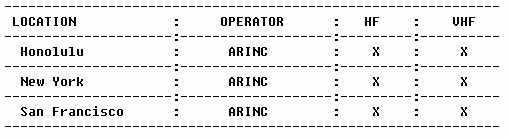
a. Guard Station. The oceanic radio station guarding for flight operations
is normally the station associated with the ATC center responsible for
the FIR (for example, Honolulu ARINC for the Anchorage FIR and Tokyo Radio
for the Tokyo FIR). At the FIR boundary the responsibility for the guard
changes, under normal signal conditions, to the station associated with
each new FIR. The flight must ensure that it has established communications
with the new guard facility. Normally, each oceanic radio station continuously
listens on all assigned frequencies. If enroute HF communications fail,
every effort should be made by the flightcrew to relay progress reports
through other aircraft. The VHF frequency 128.955 MHz is used exclusively
as an air-to-air communications channel in Pacific operations, and 131.8
MHz is used for Atlantic operations. In emergencies, however, initial contact
for such relays may be established on 121.5 MHz and transferred as necessary
to 128.95 MHz or 131.8 MHz. In normal HIF propagation conditions, appropriate
overdue action procedures are taken by ATC in the absence of position reports
or relays. In all cases of communication failure, the pilot should follow
the oceanic clearance last received and not revert to the original flight
plan (see Section 10 of this Chapter for emergency operations).
b. Use of VHF and HF for Communications. Due to the inherent line-of-sight limitations of VHF radio equipment when used for communications in international oceanic airspace, those aircraft operating on an IFR or controlled VFR flight plan beyond the communications capability of VHF are required, as per ICAO Annex 2, to maintain a continuous listening watch and communication capability on the assigned HF frequencies. Although these frequencies are designated by ATC, actual communications will be with general purpose communication facilities such as international FSS's or ARINC. These facilities are responsible for the relay of position reports and other pertinent information between the aircraft and ATC. When using these frequencies in fringe cover areas, however, care should be taken to maintain a selective calling (selcal) watch (see below) on HF, thus ensuring that if VHF contact is lost, the radio station is still able to contact the aircraft.
c. Guard of VHF Emergency Frequency. Pilots should remember that there is a need to continuously guard the VHF emergency frequency 121.5 MHz when on long overwater flights, except when communications on other VHF channels, equipment limitations, or cockpit duties prevent simultaneous guarding of two channels. Guarding of 121.5 MHz is particularly critical when operating in proximity of FIR boundaries. Pilots should not use the emergency frequency 121.5 to relay position reports and/or other information unless an actual emergency exists.
d. U.S. Aeronautical Telecommunications Services. The aeronautical voice
communications stations listed on the following page are available to,
and used, by the FAA ARTCC for ATC purposes. The frequencies in use depend
upon the time of day or night and conditions that affect radio wave propagation.
Voice communications are handled on a single channel simplex basis (aircraft
and ground station use the same frequency for transmission and reception)
unless otherwise noted. The stations remain on continuous watch for aircraft
within their communication areas, and when practical, will transfer this
watch when the aircraft reaches the limit of the communications area. The
stations that are designated "FAA" are operate d by the U.S. Federal Aviation
Administration. Those stations designated "ARINC" are operated by Aeronautical
Radio, Incorporated, 2551 Riva Road, Annapolis, MD 21401, USA; telephone
number (301) 266-4000; cable address ARINC Annapolis, Maryland.
The following chart shows examples of frequency pairings in oceanic areas. Operators should be cautioned that these frequencies change, and should be verified before using.
TELECOMMUNICATIONS SERVICES
---------
Key:
A - STATION/OPERATING AGENCY
B - RADIO CALL
C - TRANSMITTING FREQUENCY
D - REMARKS
---------
A - Honolulu/ARINC
B - Honolulu
C - 2998 4666 6532 8903 11384 13300 17904
D - Central West Pacific
C - 3467 5643 8867 13261 17904
D - South Pacific
C - 3413 5574 8843 13354 17904
D - Central East Pacific Family 1
C - 5547 11282 13288 17904
D - Central East Pacific Family 2
C - 2932 5628 6655 8951 10048 1130 13273 17904
D - North Pacific
C - 131.95
D - Extended range VHF. Covered area includes tracks to mainland extending out from HNL to approximately 400 NM. Range on other tracks approximately 300 NM
A - Honolulu/FAA
B - Honolulu Radio
C - 122.6 122.2 # 121.5
D - # Emergency. Frequency 122.1 also available for receiving only
B - Volmet
C - 2863 6679 8828 13282
D - Broadcasts at H + 00 - 05 and H + 30 - 35; airport forecasts, Honolulu, Hilo, Agana, Honolulu SIGMET. Hourly report Honolulu, Hilo, Kahului, Agana, Honolulu
D - Broadcasts at H + 05 -10 and H + 30 - 40; hourly reports, San Francisco
A - Miami/FAA
B - Miami Radio
C - 126.7 118.9 126.9 122.2 123.65 122.75
D - Local and short range
C - # 121.5
D - # Emergency
A - New York/FAA
B - New York Radio
C - 6604 10051
D - Broadcasts at H + 05 - > 10; airport forecasts Detroit, Chicago, Cleveland. Hourly reports Detroit, Chicago, Cleveland, Niagara Falls, Milwaukee, Indianapolis. Broadcasts at H + 05 - >+ 10 SIGMET (Oceanic-New York) airport forecasts
C - * 13270, * 3485
D - * Volmet broadcasts
A - New York/ARINC
B - New York
C - 3016 5598 8825 13306 17946
D - North Atlantic Family A
C - 2899 5616 8864 13291 17946
D - North Atlantic Family B
C - 2887 5550 6577 8846 8918 11396 13297 17907
D - Caribbean Family A
C - 129.90
D - Extended range
A - Oakland/FAA
B - Oakland Radio
C - 122.5 122.2 # 121.5
D - # Emergency
A - San Juan PR/FAA
B - San Juan Radio
C - 122.2 126.7 123.65 255.4 114.0 113.5 108.2 108.6 109.0 110.6
D - Unscheduled broadcasts H + 00, H + 15, H + 30 and H + 45 for weather and military activity advisories on 110.6, 109.0, 108.6, 108.2, 113.5, 114.0. For frequencies 114.0, 113.5, 108.2, 109.0 use 122.1 to transmit to San Juan Radio. For frequency 108.6 use 123.6
C - # 121.5, # 243.0
D - # Emergency
A - San Francisco/ARINC
B - San Francisco
C - 3413 5547 8843 10057 13288 17904
D - Central East Pacific One
C - 2869 5547 6673 11282 13288 17904
D - Central East Pacific Two
C - 131.95
D - Extended range
C - 129.40
D - For enroute communication for aircraft on Seattle/Anchorage routes
e. Selcal Facilities. Selcal equipment should be seriously considered
for use in both domestic and long range communications. It enables a ground
station to contact an aircraft through a combination of audio tones and
illuminated lights on the instrument panel of that aircraft, and frees
the crew from continually monitoring a given HF or VHF frequency. There
is one problem with selcal, however; single side band (SSB) signals are
incompatible with selcal signals. Many HF SSB transceivers are designed
to detect selcal transmitted in the full carrier mode even though the aircraft
transceiver mode selector is in the SSB position. Transceivers not designed
and built with this feature must have the selector switch in the full carrier
mode to detect a selcal signal. In addition, the ground station must know
the aircraft's selcal code assignment in advance.
f. Selcal Procedures. During the time that they depend on HF communications, pilots should maintain a listening watch on the assigned frequency. This is not necessary, however, if selcal is installed and used correctly. Details of correct use are as follows.
* The provisions of the selcal code are included in the ICAO flight plan
* The selcal code must be corrected if subsequently altered due to a change of aircraft or equipment
* Operation of selcal equipment must be checked with the appropriate radio station prior to selcal watch and at, or prior to, entry into oceanic airspace.
* Maintenance of a constant selcal watch.
|
g. Standard Air-Ground Message Types and Formats.
(1) REQUEST CLEARANCE.
(a) To be used in conjunction with a routine position report or to request a change in mach number, FL, or route. The content and data sequence follow:
"Request Clearance"
* Flight identification.
* Present or last reported position.
* Time over last reported position (hrs. and mins.).
* Present FL.
* Next position on assigned route or obstacle clearance altitude (OCA) entry point.
* Estimated time for next position or OCA entry point.
* Next subsequent position.
* Requested mach number, FL, or route.
* Further information or clarifying remarks.
(b) To be used to request a change in mach number when a position report message is not appropriate. The content and data sequence follow:
"Request Clearance"
* Flight identification.
* Requested mach number, FL, or route.
* Further information or clarifying remarks.
(2) REVISED ESTIMATE.
(a) To be used to upgrade time estimate for next position. The content and data sequence follow:
* Flight identification.
* Next position on route.
* Revised estimate for next position (hrs. and mins.).
* Further information.
(3) MISCELLANEOUS MESSAGE.
(a) To be used to convey information or make a request in plain language that does not conform with the content of other message format. No message designator is required as this will be inserted by the ground station. The content and data sequence follow:
* Flight identification.
* General information or request in plain language and format free.
h. Methods of Obtaining Oceanic Clearances.
* Use of VHF clearance delivery frequencies when in coverage.
* Use of HF to the OCA through the appropriate radio station (if possible at least 30 minutes before boundary/entry estimate).
* Request via domestic or other ATC agencies.
i. Summary of Communication and Reporting Procedures. Continuous contact with the controlling agency must be maintained. This can be through VHF, HF, or selcal. The range of VHF is approximately 200 NM; HF is required beyond that distance. A family of frequencies, if more than one family is monitored, is normally assigned based on route and/or the state where the aircraft is registered. These families of frequencies are listed on enroute charts.
j. Transponder.
(1) NAT - maintain last assigned squawk for 30 minutes, then squawk 2000 until advised of a discreet frequency.
(2) Pacific - Between 150 and 170 East, squawk 2000.
(3) In Bermuda TCA squawk 2100.
k. Emergency Frequencies.
(1) VHF: 121.5
(2) FM: 156.8
(3) UHF: 243.0
(4) HF: 2182/4125
8. NAVIGATION PROCEDURES.
a. Journey Logbooks. Navigational procedures must include the establishment
of some form of a master working document for use on the flight deck. This
document may be based upon the flight plan, navigation log, or other suitable
document that sequentially lists the waypoints that define the routes,
distances between the waypoints, and any other navigation information pertinent
to the cleared route. This document is known as the journey logbook. Misuse
of the journey logbook can result in serious navigational errors.
For this reason, strict procedures should be in place for use of the document. These procedures should include the following:
* Only one copy of the journey logbook should be used in the cockpit. If more than one copy is provided, one copy may be altered to reflect reclearance and other amendments to the flight plan. The unaltered copy may be used to extract navigational information that results in an unintentional deviation.
* A waypoint numbering sequence should be established from the outset of the flight. This sequence should be entered on the journey logbook and should also be used to store waypoints in the navigational computer.
* Appropriate symbology should be adopted to indicate the status of each waypoint listed on the journey logbook. For example:
(a) the waypoint number is entered against the relevant waypoint coordinates to indicate that the waypoint has been entered in the navigation computer;
(b) the number is circled to signify that entry of the coordinates in the navigation computer has been doublechecked by another crewmember;
(c) the circled number is ticked to signify that the distance information has been doublechecked; and
(d) the circled number is crossed out to signify that the aircraft has passed the waypoint.
All navigational information contained in the journey logbook must be verified against the best available primary data source. If an ATS route change is received or the ATC clearance is otherwise changed, the journey logbook must be updated to reflect the change. Old waypoints should be clearly crossed out and the new information inserted. While ATC clearances are being obtained, headsets should be worn because loudspeaker distortion has been known to result in errors. Two qualified crewmembers should monitor such clearances: one should record the information, and the other should check the receipt and read back the information. All waypoint coordinates should be read back in detail unless approved local procedures make this unnecessary. In that case, each detail must be cross-checked with the journey logbook.
b. Position Plotting. It is helpful for crews to use a plotting chart to provide themselves with a visual presentation of the intended route. Plotting the route may reveal errors or discrepancies in the navigational coordinates that can be corrected before they can cause a deviation from the ATC cleared route. As the flight progresses, plotting the position after passing each waypoint helps confirm that the flight is on course. If the position is laterally offset, the flight may be deviating unintentionally and should be investigated at once.
c. Relief Crewmembers. Flightcrews conducting very long range operations may include a relief pilot. In such cases, it is necessary to ensure that the continuity of the operation is not interrupted, especially in regard to the handling and treatment of navigational information.
d. System Alignment. INS alignment must be completed and the equipment switched to "nav" mode prior to releasing the parking brake at the ramp. There are various ways of ensuring that there is adequate time for this operation, including the following methods:
* Have the first crewmember on the flight deck place the system in align mode as early as possible.
* At short transit stops, leave the equipment in "nav" mode provided that the system errors are not so large as to require INS realignment. The decision to realign may depend on the size of the error as well as the length and nature of the next leg.
* INS batteries usually have a limited life, and cannot be recharged
onboard if allowed to run down. If the INS is left in "nav" mode during
a transit stop, or if the INS has been switched on for alignment, it is
imperative that an individual be responsible for monitoring ground power
interruption. Some INS systems provide overheat protection in "stby" and
"align," but not in other modes. During stops at tropical terminals, the
mode selector should be put directly to "align" (not through "stby," which
would cause realignment).
In the absence of abnormally high radio noise levels, Omega synchronization usually takes only a minute or so after being switched on. However, at certain ramp or gate positions, particularly those where metal structures interfere with Omega signals, synchronization may take longer or the inserted ramp coordinates may drift after insertion. Interference from ground vehicles may have a similar effect. Synchronization or dead reckoning (DR) warning lights usually indicate this situation. If the Omega equipment is serviceable, the problem usually disappears shortly after the equipment is switched to aircraft power or the aircraft is moved, but it is good practice to check the position ("pos") coordinates immediately before takeoff and make any necessary corrections.
e. Initial Insertion of Latitude and Longitude. Early in the course of the preflight check, the aircraft's position should be loaded into the INS and verified. This position must be checked against an authoritative reference source before insertion. Any latitude error in the initial position will introduce a systematic error that cannot be removed during flight by updating the resulting erroneous "pos" indications. Correct insertion of "pos" must be checked before the "align" mode is selected and the "pos" recorded in the journey logbook. Subsequently, silent checks of "pos" should be made independently by both pilots during an early stage of the preflight check. In the case of some INS, insertion errors exceeding one degree of latitude will activate a malfunction light. However, very few systems provide similar protection against erroneous longitudinal insertion errors. Care should be taken at all times to ensure that previously inserted coordinates are correct.
f. Loading of Initial Waypoints. The entry of waypoint data into the navigation system must be a coordinated operation by two people working in sequence and independently. One should key in the data, and the other person should recall and confirm the data against source information. It is not sufficient for one crewmember to simply observe another crewmember entering the data. Waypoint #1 should be used for the ramp position of the aircraft. At least two additional waypoints should be loaded while the aircraft is on the ramp; all waypoints may be loaded at this time. However, it is more important to ensure that the second waypoint is inserted accurately than to attempt to load all waypoint data. The second waypoint should be associated with the first significant position along the route (approximately 100 NM from departure point). Positions associated with ATC standard instrument departures (SID) should not normally be used for this purpose. During flight, at least two current waypoints beyond the sector being navigated should be maintained in the control display unit (CDU) until the destination ramp coordinates are loaded. The pilots should be responsible for loading, recalling, and checking the accuracy of the loaded waypoints. Each pilot should cross-check the other's work. In no case should this process engage the attention of both pilots simultaneously during flight. An acceptable procedure is for the pilots to independently load their own waypoints and then cross-check the waypoints. The pilot responsible for verification should work from the CDU display to the journey logbook, lessening the risk of seeing what is expected rather than the actual information. After the initial waypoints have been loaded, the route between waypoints I and 2 and the auto track change should be selected.
g. Flight Plan Check. The purpose of the flight plan check is to ensure complete compatibility between the journey logbook and the programming of the navigation system.
(1) "Dis/time" should be selected to verify the correct distance from
the ramp position to waypoint 2. An appropriate allowance may have to be
considered since the great circle distance shown on the CDUs may be less
than the flight plan as a consequence of the additional mileage involved
in ATC SIDs. However, a significant disparity requires a recheck of "pos"
and waypoint 2 coordinates.
(2) Select "remote" and track change 1-2. Check the accuracy of the indicated distance against that listed in the journey logbook.
(3) Select "dsrtk" and check that the desired track indicated on the CDU is the same as that in the journey logbook. This track check will reveal any errors in the latitude and longitude designators.
(4) Similar track and distance checks should be performed for subsequent pairs of waypoints and any discrepancies between the CDU information and the journey logbook. These checks can be coordinated between the pilots against the journey logbook.
(5) After checking each leg of the flight as described above, a note should be made on the journey logbook using the appropriate symbols.
h. Leaving the Ramp. If the aircraft is moved before the "nav" mode is initiated, the INS must be realigned. The aircraft should be relocated so that it does not block the gate or otherwise interfere with traffic while the realignment takes place. After leaving the ramp, INS ground speeds should be checked. A check of the malfunction codes should be made while the aircraft is stopped but after it has taxied at least part of the way to the takeoff position. Any significant groundspeed indication while stationary may indicate a faulty unit. This check does not normally apply in the case of Omega, because such equipment is usually inhibited from providing speed indicators until the aircraft is airborne. Omega position indicators should be checked before takeoff if there is a possibility of error induced by signal interference.
i. Inflight. If the initial part of the flight is conducted along airways, the airways facilities should be used as the primary navigational aids and the aircraft navigation system should be monitored to ascertain which system is giving the most accurate performance.
j. Approaching the Ocean. Before entering oceanic airspace, the aircraft's position should be checked as accurately as possible by using external navigation aids (navaids) to ascertain the aircraft navigation system to be used. This may require distance measuring equipment (DME)/DME and/or DME/VHF omnidirectional radio range (VOR) checks to determine navigation system errors through displayed and actual positions. In the event of significant discrepancies (greater than 6 NM), updating the navigation system should be considered. Updating is normally not recommended when the discrepancy is less than 6 NM. The duration of the flight before the oceanic boundary and the accuracy of the external navigation system are factors that influence any decision to update the system. If the system is updated, the proper procedures should be followed with the aid of a prepared checklist. The navigation system that performs the most accurately should be selected for autocoupling. In view of the importance of following the correct track in oceanic airspace, some operators advise that the third pilot or equivalent crewmember should check the inserted waypoints using appropriate source information.
k. Oceanic Boundary Position Report. Just prior to the oceanic boundary and prior to any waypoint, the present position coordinates should be monitored, recorded, and verified. The coordinates for the next waypoint should be monitored and verified. When the CDU alert light comes on, the crew should note and record the present position on the journey logbook. This information should be verified against the current clearance on the journey logbook. The waypoint number on the journey logbook should be annotated with the appropriate symbol to indicate that it has been verified. If the oceanic boundary position report is made over a VOR facility, the appropriate radial to the first oceanic waypoint should be selected as further check that the navigation system is tracking according to the current clearance. If DME is available, distance check can also be performed.
l. At an Oceanic Waypoint. Coordinates of the next two waypoints should
be verified against the master document. When sending the ATC position
report, the coordinates should be copied from the journey logbook or the
present position and the next two forward positions can be read from the
CDU. As soon as the waypoint alert light goes on, the present position
coordinates of each navigation system should be checked against the current
clearance to ensure that the position report coincides with the actual
position of the aircraft and the ATC clearance. Over the waypoint, the
pilots should verify that the aircraft is headed in the right direction
and takes up the heading appropriate to the leg to the next waypoint. The
coordinates of the next waypoint should be verified against the journey
logbook. After the ATC position report is sent, the present position should
be plotted to ensure that the tracking is correct. The crew should be particularly
alert in maintaining selcal watch in the event of possible ATC followup
to the position watch.
m. Routine Monitoring. There are a number of ways in which the autopilot may accidentally become disconnected from the command mode. Regular checks of correct engagement should be made. Although it is a common practice to display "dis/time," it is recommended that the navigation system coupled to the autopilot should display the present position coordinates throughout the flight. If the coordinates are plotted at roughly 20 minute intervals, they will confirm that the flight is on track according to the ATC clearance. Distance-to-go information should be available on the instrument panel, and the waypoint alert light provides a reminder of the proximity of the waypoint. If a position check and verification are being made at each waypoint and 10 minutes after each waypoint, additional plotting every 20 minutes may be counterproductive during routine flight. The navigation equipment not being used to steer the aircraft should display crosstrack error (XTK) and track angle error (TKE). These indicators should be monitored, with XTK being displayed on the horizontal situation indicator (HSI) when feasible.
n. Use of Radar. Aircraft equipped with airborne weather radar capable of ground mapping should use the radar to observe any land masses as an aid to determining the accuracy of their navigation. Aircraft conducting NOPAC operations under U.S. civil certification are required to be equipped with functioning weather radar approved for day and night operation. The flightcrews must use the radar on a constant basis during flight to monitor navigation system accuracy.
o. Approaching Landfall. When the aircraft is approaching the first landfall navaid, it should acquire the appropriate inbound radial as soon as the flightcrew is confident that the navaid's information is accurate. The aircraft should be flown to track by means of radio navigation and fly over the facility, which becomes the primary navigational guidance after leaving the oceanic area.
p. Navigation System Accuracy Check. At the end of each flight, the accuracy of the navigational system should be determined to facilitate correction of performance. A check to determine the radial error at the ramp position may be performed as soon as the aircraft is parked. Radial errors in excess of 2 NM per hour are generally considered excessive. Records should be kept of navigation systems performance.
q. Monitoring During Distractions. Training and drills ensure that minor emergencies or interruptions of normal routine do not distract the crew to the extent that the navigation system is mishandled. If the autopilot is disconnected during flight, it must be reengaged carefully to ensure that the correct procedure is followed.
r. Avoiding Confusion Between Magnetic and True. To cover all navigation requirements, some air carriers produce flight plans that include both magnetic and true tracks. If crews are changing to a new system, there is a risk of confusion in selecting the correct values. Operators should devise drills to reduce this risk and ensure that the subject is covered during training. Crews that check or update their long range navigation systems (LRNS) by reference to VOR located in the Canadian Northern Control Area should remember that they are not aligned with reference to magnetic north.
s. Navigation in Areas of Magnetic Unreliability. In areas of compass unreliability, basic INS operations require no special procedures. However, many operators retain an independent heading reference in case of INS failure. There are a number of ways to accomplish this. For example, Omega requires heading input from an external source. Different manufactures offer their own solutions to special problems in magnetic unreliability. Such solutions should not involve the use of charts or manual measurement of direction.
t. Deliberate Deviations. Temporary deviations from track are sometimes necessary, but prior ATC clearance should be obtained. Such deviations can cause gross navigation errors (GNE) if the autopilot is not re-engaged. Selection of the autopilot turbulence mode can disengage the autopilot from the navigation system. After using turbulence mode, the aircraft must be flown back to the desired track before the autopilot is re-engaged. The following steps are useful in preventing GNEs as a result of deviations around severe weather:
(1) The autopilot turn control knob is used to turn the aircraft in the desired direction
(2) The autopilot engage switch will automatically move from "command" to "manual." The altitude mode switch will either remain in "altitude hold," or if in the "altitude select" mode, will trip to "off"
(3) The steering CDU selector is set to XTK/TKE to provide a continuous display of crosstrack data.
(4) If turbulence is encountered, the "turb" setting on the speed mode selector may be used. In this case, the altitude mode switch automatically positions to "off."
(5) Both radio INS switches remain in the INS position. This provides a visual display of the navigation situation on the HSI. Even if more than 8 NM off the track, the pegged needle on the HSI is a reminder of that fact and confirms whether the aircraft is tracking towards, away from, or parallel to the desired track.
(6) The turn control knob should be used to maneuver the aircraft as necessary.
(7) When clear of the severe weather, the aircraft should be steered back to the desired track, guided by the steering CDU to zero the XTK indication.
(8) When the aircraft returns to the desired track, the autopilot engage switch is set to "command" and the altitude mode switch to "altitude hold." The navigation mode selector should still be in the INS position.
(9) The captain and first officer, or the entire crew if possible, should monitor the diversion maneuver to ensure that the aircraft has returned to the desired track and the autopilot is properly reengaged for command INS operation.
(10) After return to route has been completed, check the assigned mach number and advise ATC.
u. ATC Reclearance. Experience suggests that when ATC issues a clearance involving rerouting and new waypoints, the risk of errors increases. The procedures used to copy the ATC clearance, load and check the waypoints, verify the flight plan information, and prepare a new plotting chart should be the same as the procedures for beginning a flight. One pilot should be designated to fly the aircraft while the other pilot reprograms the navigation systems and amends the cockpit documents. In the event that a reclearance involves a direct routing, data relevant to the original route should be retained in case the aircraft is required by ATC to return to its original course.
v. Detecting Failures. INS, GPS, and Omega installations normally include comparator and/or warning devices, but the crew must still make frequent comparison checks. With three systems on board, identification of a defective system should be straightforward. During the acceleration phase of flight, Omega groundspeed indicators are likely to be less accurate than INS and should not be used in comparison checks. With only two systems on board, identifying system failures is more difficult before significant deviations occur. If a significant deviation occurs in oceanic airspace, nearby aircraft can be contacted on 128.9 MHz and information can be obtained to aid in identifying a system failure. A record of Omega and INS performance should be maintained and kept available for crews. The following are suggestions for recordkeeping:
(1) Before takeoff and while stationary, note the INS groundspeed and
"pos" indicators. These may give an indication of system accuracy.
(2) The accuracy of each unit should be noted before reaching oceanic airspace, preferably while passing a convenient short range facility. A further record should be made at the destination regarding terminal error after first canceling any inflight updates that were made.
(3) Compass deviation checks (INS only) can be made to determine deviation values for the magnetic compass systems so that the accuracy of INS heading outputs can be checked inflight.
w. Identifying Faulty Systems.
(1) Check malfunction codes for indications of unservicability.
(2) Refer to records for indications of prior problems.
(3) Obtain a fix, possibly using the weather radar, to determine position and compare to information from the systems.
(4) Communicate with nearby aircraft on air-to-air VHF to compare information on spot wind, groundspeed, and drift. If no aircraft can be contacted, compare information from the prognostic chart to the system readout. This method should be a last resort, and preferably should be used with another method of verification.
(5) Use the heading method (INS only). Simultaneously read both INS and magnetic compass indicators. Obtain the mean to the nearest degree to get an acceptably accurate true heading value to compare to the INS readings and determine what reading is inaccurate.
x. When Faulty Systems Cannot be Identified. Situations may arise when distance or crosstrack differences develop between two LRNSs, but the crew cannot identify the faulty system. If three systems are on board, the two agreeing systems can be accepted as reliable signals. If, however, only two systems are on board and they disagree, most operators believe that the best procedure in this instance is to fly the aircraft halfway between the crosstrack differences as long as uncertainty exists. ATC must be informed that the flight is experiencing navigation difficulties so that appropriate clearances may be obtained.
y. What Constitutes a Failed System. Crews must be able to determine when an INS or Omega system should be considered to have failed. INS failure may be indicated by the red warning light or self-diagnostic indications, or by an error over a known position exceeding the value agreed upon by the operator and the certifying authority. Generally, if there is a difference of greater than 15 NM between the two aircraft's navigation systems, it is advisable to split the difference to determine the aircraft's position. If the disparity exceeds 25 NM, one or more of the systems should be regarded as having failed and ATC should be notified. In the case of Omega, estimates of position error are easier to determine because it is likely the system using the greater number of ground stations will be the most reliable. Omega failure may be indicated by a red warning light or by built-in test equipment (BITE) indications.
z. Loss of Navigation Capability. There are two navigational requirements for NOPAC operations. One refers to the navigation performance that should be achieved; the second to the need to carry standby equipment with comparable performance characteristics. Some aircraft carry triplex equipment so that if one system fails the requirements are still met. The following guidance is for aircraft with two systems.
(1) If one system fails before takeoff, the pilot should consider delaying departure if repair is possible, or obtaining a clearance for below FL 280, if practical.
(2) If a system fails before an oceanic boundary is reached, the pilot should consider landing at a suitable airport before the boundary, returning to the departure airport, or obtaining a reclearance below FL 280.
(3) If a system fails while the aircraft is in oceanic airspace, the pilot should continue the flight according to the ATC clearance already obtained while keeping in mind that the reliability of the navigational information is significantly reduced. The pilot should assess the reliability of the remaining system and contact ATC with a proposed course of action. ATC clearance must be obtained before any deviation to the existing clearance is made.
(4) While continuing flight in oceanic airspace with a failed system, the pilot should monitor the following:
* the operation of the remaining system;
* check the main and standby compass reading against available information; and
* check the performance record for the remaining system. If there is doubt about the reliability of the remaining system, the pilot should attempt visual sighting of other aircraft contrails for a track indication, call the appropriate ATC facility to get information on the location of adjacent aircraft, and establish air-to-air communication with nearby aircraft on 128.95 MHz.
(5) If the remaining system fails or indicates degradation of performance, the pilot should notify ATC, obtain all possible information from other aircraft, keep visual watch for other aircraft, use all possible outside lights, and use any necessary contingency procedures.
9. OPERATIONS.
a. Overview. Oceanic operating procedures differ depending upon the size of the aircraft, type and number of powerplants, range with or without long range tanks installed, operation type (general or commercial), navigation equipment installed, state (country) of departure, body of water to be transversed, and the qualifications of the flightcrew. The following chapters discuss operational factors required for the Atlantic, Pacific, Gulf of Mexico, and the Caribbean. Various types of navigation equipment are also discussed. It is the pilot's responsibility to read the sections that pertain to the flight in addition to the general discussion in this Chapter. The most stringent conditions exist in the Northern Atlantic due to the high density of traffic between North America and Europe. The most hazardous area for light aircraft is the long route between the U.S. west coast and the Hawaiian Islands.
b. U.S. Registered Aircraft. FAA inspectors will ensure that contingency procedures specific to the authorized area of operation are detailed in U.S. registered air carrier operator's training and check airman programs and manuals. In the case of non air carrier operators, these same procedures must be demonstrated to inspectors prior to obtaining an LOA for operations in special airspace. It should be emphasized that the improper application of contingency procedures can result in collision with other aircraft. Further inherent in contingency procedures is the requirement to contact ATC whenever the aircraft is unable to continue flight according to its current ATC clearance. This includes situations when the aircraft is off course and/ or unable to maintain its assigned altitude. A failure to comply with this requirement prevents ATC from taking measures to provide separation between adjacent aircraft and the aircraft that has deviated from its clearance. Failure to contact ATC is also contrary to ICAO Annex 2 and FAR 91.703, the latter of which requires compliance with Annex 2 by all aircraft of U.S. registry. Contingency procedures for NAT MNPS airspace can be found in Chapter 3 of this AC. For aircraft operating in the NOPAC composite route system, contingency procedures can be found in Chapter 4 of this AC. Navigation specialists are available within the FAA to aid district offices in their initial and ongoing evaluation of operator's navigation programs. If there are questions concerning any aspect of navigation programs, contact: Federal Aviation Administration, Flight Standards National Field Office, AFS-500, P.O. Box 20034, Washington, DC 20041, (703) 661-0333.
10. EXTENDED RANGE OPERATIONS WITH TWO ENGINE AIRPLANES (ETOPS).
Operators desiring to obtain approval under FAR 121.161 for two engine
airplanes to operate over a route that contains a point farther than 1
hour flying time at the normal one engine inoperative cruise speed (in
still air) from an adequate airport should refer to AC 120-42, "Extended
Range Operation with Two Engine Airplanes (ETOPS)." This AC defines the
tasks that must be accomplished by an operator in preparation for the monitoring
process that will be, undertaken by the FAA principal maintenance inspector
(PMI). This monitoring process is necessary to obtain an ETOPS authorization
which requires an approval from the Director, Flight Standards Service,
for a deviation to the operating rule of FAR 121.61. To meet the requirements
of this deviation, the operator must be able to substantiate that the type
design reliability and the performance of the proposed airplane/engine
combination have been evaluated per the guidance in AC 120-42A and have
been found suitable for extended range operations, and submit an application
package that includes supplemental maintenance requirements and programs
that allow for safe operations under an ETOPS authorization.
11. EMERGENCY PROCEDURES.
a. Introduction. When conducting flights, especially extended flights, outside the United States and its territories, full consideration should be given to the quality and availability of air navigation services in the airspace to be used. As much information as possible should be obtained concerning the location and range of navaids and availability of SAR services. SAR international standards and recommended practices are contained in Annex 12 to the Convention. Each ICAO region has published air navigation plans that include the facilities, services, and procedures required for international air navigation within that particular region.
b. Pilot Procedures. Any pilot who experiences an emergency (alert, distress, uncertainty) during flight should take three steps to obtain assistance.
(1) If equipped with radar beacon transponder and unable to establish voice communication with ATC, switch to Mode A/3 and Code 7700. If crash is imminent and the aircraft is equipped with an emergency locator transmitter (ELT), activate the emergency signal if possible.
(2) Transmit as much of the following message as possible on the appropriate air-ground frequency, preferably in the order shown below:
(a) "Mayday, mayday, mayday" for distress, "pan, pan, pan" for other types of emergency;
(b) WHO - name of station addressed, circumstances permitting;
(c) WHAT - nature of the distress Or emergency condition, intentions of the person in command; and
(d) WHERE - present position, FL, altitude, and any other useful information.
The most important parts of the message are who, what, and where. If no response is received on the air-ground frequency, repeat the message on the aeronautical stations on 121.5 MHz. Other useful frequencies for attracting the attention of a maritime station are distress frequencies 2182 or 4125 KHz. An aircraft in distress may use any available means, including any frequency, to attract attention and make known the situation.
(3) Comply with the information and clearances received. Accept the communications control offered by the ground radio station, silence any interfering radio stations, and do not shift frequency or shift to a ground station unless absolutely necessary or instructed to do so.
c. Two way Radio Failure. Pilots of flights that experience two-way radio failure are expected to follow the applicable procedures. If the pilot is lost, or is otherwise unable to follow procedures, the pilot may attempt to alert civilian or military radar systems in the area of operation. The pilot should remember that there are two ways to declare an emergency: squawk emergency on the transponder - 7700; or send an emergency message - 121.5 MHz. Ground stations have various electronic means of assisting in these situations, including receipt of emergency procedures, direction finding (DF) bearings, and detection of transponder emergency squawk.
d. The Four Cs. When confronted with an emergency, pilots should remember
the four Cs:
(1) Confess the situation to any ground station. Don't wait too long.
(2) Communicate with the ground link and convey as much of the distress message as possible on the first transmission.
(3) Climb if possible for better radar and DF detection. If flying at a low altitude, chances of radio contact are improved by climbing. Chances of alerting radar systems may be improved by climbing or descending. Note that unauthorized climb or descent under IFR conditions within controlled airspace is prohibited except in an emergency. Any variation in altitude is unknown to ATC unless the facility has radar with height finding capability.
(4) Comply with advice, information, and clearances received. Assist the ground control station in controlling communications on the distress frequency in use. Instruct interfering stations to maintain radio silence until needed.
For ditching or crash landing, if there is no additional risk of fire and circumstances permit, the radio should be set for continuous transmission. If a pilot is apprehensive or doubtful about a situation, assistance should be requested. SAR facilities are ready and willing to help. There is no penalty for their use. Safety is not a luxury; the pilot must take action.
e. Search and Rescue. SAR is a life-saving service provided by many governments that are assisted by aviation and other organizations. This service provides search, survival aid, and rescue of personnel of missing or crashed aircraft. Before departure, a responsible individual at the departure point should be advised of the flight plan and itinerary. Search efforts are often wasted, and rescue is delayed, because a pilot departed without informing anyone of the flight plan. To protect all personnel on the aircraft, these steps should be followed:
(1) File a flight plan with the appropriate authority in person, by telephone, or by radio.
(2) Close the flight plan with the appropriate authority immediately upon landing.
(3) If the flight lands at other than the intended destination, report the landing immediately to the appropriate authority.
(4) If an enroute landing is delayed more than 30 minutes (for turbojets), notify the appropriate authority.
(5) Failure to close a flight plan within 30 minutes of landing may initiate a search.
f. Crashed Aircraft. If a crashed aircraft is observed, determine if the crash is marked with a yellow cross. If so, the crash has been reported and identified. If the site is not marked with a yellow cross, determine, if possible, the type and number of aircraft and whether there is evidence of survivors. Fix the location of the crash as accurately as possible, and transmit the information to the nearest appropriate communication facility. If possible, orbit the scene to guide other assisting aircraft until relieved by another aircraft. Immediately after landing, make a full report to the appropriate authority.
g. Crash Landing Survival and Rescue. To enhance the chances of survival and rescue in the event of a crash landing, it is important to carry survival equipment suitable to the areas the flight passes over. If a forced landing occurs at sea, survival chances are governed by the crew's proficiency in emergency procedures and the effectiveness of water survival equipment on board the aircraft. In the event that an emergency water landing is required, the crew should contact the Coast Guard and request Automated Merchant Vessel Report (AMVER) system information. Within minutes the crew will be given the name and location of every merchant vessel within 100 miles of the aircraft's reported position. The speed of rescue on land or at sea depends upon how accurately the position is determined. If the flight plan has been followed and the position is on course, rescue is expedited. Unless there is good reason to believe that the crash site cannot be located by search aircraft, it is best to remain near the aircraft and prepare to signal when search aircraft approach.
h. Ditching and Evacuation. When a forewarned ditch is imminent, the first step is to communicate with oceanic control and the passengers. The PIC should initiate the distress call to the appropriate agency per ATC instructions or as indicated in the IFIM. When contacting oceanic control, give the following information: aircraft identification; timed position; altitude; ground speed; true course; hours of fuel remaining; a description of the emergency; pilot's intentions; and the assistance desired. Oceanic control will report the situation to the Coast Guard. The Coast Guard activates the AMVER system, sending a seagoing vessel to the area.
i. International Procedures. A Coast Guard station or a nearby ship can furnish information on the surface wind, recommended ditching heading, and sea conditions in the event of a ditching. The pilot in range of a ship should ditch in close proximity to the vessel, which will stand by to pick up passengers and assist in any other way.
The passengers and crew must be prepared prior to ditching. Lifevests must be put on, seatbelts fastened, impact position must be assumed, and loose articles must be stowed. The passengers should then be briefed on lifevest inflation and evacuation of the aircraft. Crewmembers should make an inspection to ensure that life jackets are properly worn. Personnel should be paired off in preparation for evacuation. Older persons should be paired with able-bodied men to assist them. Children and nonswimmers should be paired with swimmers whenever possible; experienced swimmers should be paired with more dependent persons. To avoid injury, passengers must remain in their seats during the ditching, and must brace themselves to meet at least two impacts in the manner instructed by the flightcrew. The method of bracing is determined by the location and arrangement of the seats and by selection of the crash position. Regardless of the method or location, seatbelts should be strapped as tightly as possible across the hipbones. The recommended ditching position is to adjust the seat to vertical position. Just before landing, fold the arms and rest them on the knees. Bend the body as far forward as possible, and rest the head firmly on the arms. If available, a pillow, blanket, or clothing should be held in front of the head to cushion any impact. Illustrated ditching cards are helpful in showing the desired position.
It is usually best for the pilot to observe the sea surface from 2,000 feet to determine the primary swell direction. Wind condition permitting, the landing should be parallel to the swells. When the PIC advises that ditching is imminent, a crewmember or flight attendant should attach the emergency escape lifelines, position the liferafts near the emergency exits, attach the liferaft lanyards to the chair tracks, and assume a position where the passengers can be monitored during the ditching. If there is an available passenger seat, the crewmember or flight attendant should consider occupying the seat with immediate access to the emergency escape window. This position should be coordinated with the cockpit crewmembers, so that one person opens the escape hatches on the opposite side, and each is responsible for securing the appropriate lifeline, inflating and launching the liferaft, and aiding the passengers in evacuating the aircraft. A public address announcement should be made immediately before impact advising the passengers that there will be at least two impacts. The passengers should be advised to "stand by for ditching" at 1,000 feet or 2 minutes before ditching. Prior to impact, the command "brace for impact" should be given. Passengers and crew should not release their shoulder harnesses or seatbelts until the aircraft is at a complete stop. The passengers should hold the crash position until the aircraft has stopped.
j. Evacuation. Once the aircraft is stopped, release seatbelts and shoulder harnesses and move quickly to the cabin door. The PIC should be in command of the evacuation, and should expedite evacuation of passengers and flight personnel. Lifevests must be inflated as soon as the passengers exit the aircraft.
k. Liferafts. Most corporate aircraft stow liferafts in the rear of
the aircraft. Consequently, it is imperative for the rafts to be moved
near the exits before impact. It is equally important that the rafts be
secured so that they will remain near the exits during ditching. The rafts
must be secured to the aircraft before being deployed to prevent the raft
from being carried away. The last step is raft inflation by jerking the
lanyards to release the cover and begin inflation. Once the rafts are inflated,
passengers should board the rafts and ensure the load is evenly distributed.
The sea anchor is then deployed and the torus section is inflated. Canopy
poles are then installed and the canopy is erected or inflated. Care must
be taken to ensure that the canopy is not lost in strong winds.
l. Signaling. Signaling and survival equipment are usually located in the torus section of the raft. Signaling equipment usually includes locator beacons, flares, flashlight, mirror, and possibly a transceiver radio. The locator beacon, depending on design, can be used continuously or intermittently. Other signaling devices should not be used unless an aircraft or surface vessel is heard or seen. If a transceiver radio is available, it used be used to transmit in blind to attract attention. These radios usually have a battery with a 20 - 30 hours life span.
m. Survival. Mental attitude cannot be overemphasized when discussing survival. The crew must demonstrate total confidence that rescue is simply a matter of time. The right attitude also reinforces a will to live even when physical condition is at its lowest point. All rafts should be equipped with water desalting kits, and rain water should be trapped on the canopy and collected. Any injuries sustained during ditching should be treated as soon as possible. Food and water are important; however, life can be sustained for up to 6 days without water and up to 3 weeks without food. The crew's proficiency is the single most important element. Once the ditching and evacuation of the aircraft is completed, chances of survival are very good.
n. Pyrotechnic Signaling Devices. FAR Parts 91, 121, 125, and 135 require
the carriage of at least one signaling device for extended overwater operations.
For the purpose of this AC, "Coast Guard approved" refers to the minimum
standards suggested by the FAA for the acquisition and use of pyrotechnic
visual distress signaling devices. Reliance on Coast Guard expertise in
this area is a result of their historical involvement with the entire spectrum
of SAR techniques. There is a wide variety of signaling devices available,
and no single device is ideal under all circumstances. Pyrotechnics make
excellent distress signals, but the drawback is that they can only be used
once. Coast Guard approved visual distress signaling devices fall into
three general categories: daylight signals, night signals, and devices
acceptable for both day and night use. Red hand-held flares can be used
by day, but are most effective at night or in restricted visibility. Hand-held
devices may expel ash and slag as they bum. The flare itself is very hot
and can cause a fire if dropped. Caution should be used to ensure that
the device does not drip onto persons or flammable materials. Orange smoke
signals, both floating and hand-held, are good for day use, particularly
on clear days. The signals are effective in light or moderate winds. However,
higher winds tend to keep the smoke close to the water and disperse it.
Red parachute flares, both pistol and rocket propelled, are good signals
for day and night use because of their altitude, slow descent, and intensity.
However, the slow descent can make them drift away from the site and lead
rescuers astray. Pistol launched or self-contained rocket propelled red
meteors are not effective at night. Because of their rapid descent, they
are less affected by the wind. However, the burning time is shorter and
therefore the signals are not as readily observed. When using one of these
devices, the wind must be taken into account. In calm winds, the device
should be fired away from the wind at a 60 degree arc to the horizon. As
wind increases, increase the angle to no more than 80 - 85 degrees. No
pyrotechnic device should be fired straight up in calm winds; the device
can fall back on the individual. Pyrotechnic devices should be stored in
a cool, dry location and must be readily accessible in event of an emergency.
A watertight container clearly marked "Distress Signals" is recommended.
Coast Guard approved pyrotechnic devices have a service life expiration
date. At this time, the expiration date may not exceed 42 months from the
date of manufacture.
-----------
Key:
A - NUMBER MARKED ON DEVICE
B - DESCRIPTION OF DEVICE
C - ACCEPTED FOR USE
-----------
A - 160.021
B - Hand-held red flare distress signal.
C - Day & night
A - 160.022
B - Floating orange smoke distress signal (5 minutes).
C - Day only
A - 160.024, 160.028
B - Pistol-projected parachute red flare distress signal. Must be used
with a suitable approved launching device.
C - Day & night
A - 160.036
B - Self-contained rocket propelled parachute red flare distress signal.
C - Day & night
A - 160.037
B - Hand-held orange smoke distress signal.
C - Day only
A - 160.057
B - Floating orange smoke distress signal (15 minutes).
C - Day only
A - 160.066
B - Red aerial pyrotechnical flare distress signal. May be meteor or
parachute type and may need an approved suitable launching device.
C - Day & night
12. MONITORING OF NAVIGATION SYSTEM PERFORMANCE.
a. The Monitoring Process. To ensure compliance with any MNPS, states need to establish procedures for the systematic or periodic monitoring of the navigation performance actually achieved. This should be supported by formal notification of PIC's, operators, and states of registry of any gross deviations from assigned track. Close cooperation between flightcrews, operators, and aviation authorities is required to ensure that unsatisfactory performance is recognized and corrected. Incident reporting procedures that encourage cooperation by the flight crewmembers involved are essential to safe operations. In the event of a significant deterioration in navigation performance, whether the product of random excursions by operators or the result of an equipment system's low performance level, corrective action is required. In this situation, ATC must accept responsibility for advising user states and operators, either directly or through the Central Monitoring Agency (CMA), of the action being taken to correct the situation. In the absence of an agreement with the concerned state(s) to exclude offending aircraft from the system, it may be necessary to temporarily increase separation while resolving the problem.
The monitoring process includes four distinct actions:
* Monitoring the operator's navigation performance in cooperation with the flightcrew.
* Monitoring of the operator by the state having jurisdiction over that operator to ensure that adequate provisions are being applied by the operator while conducting authorized flight operations.
* Monitoring of actual navigation performance during normal flight operations by means of radar used by the ATC units of states providing service in the region.
* Monitoring can also be done on the basis of position reporting.
Because of the large variety of circumstances existing in the relationships between states and their operators engaged in oceanic operations, it is not expected that all states will make maximum effort to comply with the responsibilities resulting from the application of special airspace restrictions (such as MNPS) while keeping administrative arrangements within reasonable limits.
b. Monitoring by the Operators. While operators understandably want to avoid excessive documentation, post flight monitoring and analysis should be carried out for two important reasons: it facilitates the investigation of any reported gross navigational errors (GNTE), and assists in identifying any deterioration in equipment performance (refer to the definition of GNE in Appendix 4).
Decisions regarding monitoring of an aircraft's navigation performance
are largely the prerogative of individual operators. In deciding what records
should be kept, airlines should consider the stringent requirements associated
with special airspaces such as MNPS. Airlines are required to investigate
all errors of 20 NM or greater in MNPS airspace. Whether these deviations
are observed by radar or by the flightcrew, it is imperative that the cause
of the deviation be determined and eliminated. Therefore, it is necessary
to keep complete inflight records so that any analysis can be made.
Operators should review their documentation to ensure that it provides all the information required to reconstruct the flight, if necessary, some weeks later. These records also satisfy the ICAO regulation that a flight journal be kept. Specific requirements could include, but are not limited to, the following:
* details of the initial position inserted in the equipment, original planned flight track, and flight levels;
* all ATC clearances and revisions;
* all reports (times, positions, etc.) made to ATC;
* all information used in the actual navigation of the flight, including a record of waypoint numbers allocated to specific points, estimated time of arrival (ETA) and actual times of arrival (ATA);
* routine monitoring of Omega navigation system (ONS)/very low frequency (VLF) station signals in use/strength;
* comments on any navigation problems relating to the flight, including information on any significant discrepancies between inertial navigation system (INS) and/or Omega displays, other equipment abnormalities, and any discrepancies relating to ATC clearances or information passed to the aircraft following ground radar observations;
* sufficient information on accuracy checks to permit an overall performance assessment;
* records of terminal errors and of checks made against navigation facilities immediately prior to entering oceanic airspace and, to the extent possible, details of the Omega/VLF signals in use; and
* details of any manual updates made to INS or Omega units.
It is also important that the forms used for the trip journal make it easy to examine key factors. Therefore, documentation might include a question to the crew such as, "Did a track error of 20 NM or more occur on this flight? Yes/No."
c. Monitoring of the Operator by the State. Decisions regarding the monitoring of operators by the state may be taken unilaterally, but there should be a cooperative process concerning the specifications to be satisfied by the operator while planning and reviewing achieved performance. Much of this process involves FAA-approved procedures and monitoring to ensure compliance. Varied circumstances influence the relationships between states and their operators, and also impact monitoring functions. Certain states require operators to maintain an aircraft log in which the crew records the performance of the navigation equipment. This log is used as a basis for investigation if significant equipment deficiencies occur. Other states require operators to use a form to record the performance of INS and Omega navigation equipment. The more complex the form, the more problems are likely to be encountered in its compilation and analysis. Separate forms may be justified for Omega and INS. States can use whatever methods or forms they prefer, but should carefully consider what information is necessary. Examples of factors to consider include:
(1) Warnings of deteriorating INS accuracy.
(2) Provision of a simple record to facilitate analysis of deviations.
(3) A record of performance of flight operation in areas where there is no radar coverage.
In the case of Omega, there have been reports of the metallic structure
of a terminal building adversely affecting navigation readouts. It may
be more appropriate to record readings shortly after landing and before
taxiing, or over a landfall point after an oceanic crossing. Such readings
give a less reliable picture of the overwater performance than is the case
with INS. However, they are likely to indicate a large error that might
result from a "lane slip." If a GNE is attributed to the use of Omega,
a report should be completed by the operator and forwarded to the Omega
Association, with a copy to the Central Monitoring Agency. The addresses
of these organizations are contained in Appendix 1,
Figure 1-4 of this AC.
d. Direct Action by States in the Monitoring Process. Apart from the monitoring functions of operators and states having jurisdiction over operators flying in the NAT region, it is vital to monitor actual navigation performance as observed by ATC radars of NAT provider states. This monitoring function covers four distinct phases:
(1) The acquisition and use of monitoring data.
(2) Action by the ATC unit in the case of radar observed flight deviations, including followup action by the operator and/or state concerned.
(3) Periodic issuances of a summary of radar observed deviations to all interested states and international organizations to apprise users of the general situation in the NAT region regarding navigation performance achieved by flights.
(4) The collection of specific data on navigational performance by all
flights, to serve as a basis for the assessment of compliance to the special
navigation area requirements by all traffic in the oceanic airspace concerned
by its application and the relationship to the safety of separation standards
used. The following are checklists of items discussed in this chapter,
and are provided as a convenience to the reader. The checklists do not
necessarily include every item that must be checked for an international
flight.
1. PERSONAL DOCUMENTS
Airmen's Certificate
Physical
Passport
Extra Photos
Visa (if required)
Tourist Card (if required)
Immunization Records (PHS-731)
Traveler's Checks
Credit Cards
Cash
Passenger manifest (Full name, Passport no.)
Trip itinerary
2. AIRCRAFT DOCUMENTS
Airworthiness Certificate
Registration
Radio licenses
MNPS Certification (if flying in MNPS airspace)
Aircraft flight manual
Maintenance records
Certification of insurance (U.S. Military (if planning on using a military
base) or foreign)
Import papers (for aircraft of foreign manufacture)
3. OPERATIONS PERMITS
Flight authorization letter
Overflight permit
Landing permits
Advance Notice
Export licenses (nav. equipm)
Military (including corridor briefing)
Customs overflight
Customs Landing Rights
4. INSPECTIONS
Customs forms
Immigrations
Agricultural (disinfectant)
General declarations
5. GROUND HANDLING
Handling agents
FBOs
Fuel (credit cards, carnets)
6. COMMUNICATIONS & NAVIGATION EQUIPMENT
VHF
UHF
HF SSB
Headphones
Portables (ELTs, etc.)
Spares
7. AGREEMENTS
ARINC
BERNA
STOCKHOLM
8. NAVIGATION EQUIPMENT
VOR
DME
INERTIAL
VLF/OMEGA
LORAN
GPS
9. PUBLICATIONS
Updated aircraft documents
Charts
Sectionals
WACs
Plotting
Approach
Area
Terminal
ONCs
FLIPs
NAT message (current for North Atlantic)
Flight Plans
ICAO completed
Blank ICAO
Flight Plans
Operations manual
International Flight Information Manual
Maintenance manuals
Manufacturer's equipment source list
Customs Guide
10. WEATHER
Wind Factors enroute and consideration for the calculation of ETPs (Equal
Time Points of No Return)
Boeing Seasonal Wind Factor
IATA Seasonal Wind Factor
Current Route Wind Factor
(What weather reporting services is intended to be used?)
11. SURVIVAL EQUIPMENT
Area survival kit (with text)
Medical kit (with text)
Emergency Locator Transmitter
Floatation equipment
12. FACILITATION AIDS
U.S. Department of State
U.S. Dept of Commerce
U.S. Customs Service
National Flight Data Center (FAA)
FAA Office of International Aviation (AFS-5)
FAA Aviation Security (ACO-100)
13. OTHER CHECK LIST CONSIDERATIONS
Preflight Planner
Aircraft locks
Spare keys
Security devices
Commissary supplies
Electrical adapters (razors, etc.)
Ground transportation
Hotel reservations
Catering
Slot reservations