1. CHARACTERISTICS OF THE AIRSPACE.
a. Introduction. The North Atlantic (NAT) region includes the following flight information regions (FIR): Bodo Oceanic, Gander Oceanic, New York Oceanic, Reykjavik, Santa Maria Oceanic, Shanwick Oceanic, and Sondrestrom. Most of the airspace in these FIRs is high seas airspace, wherein the International Civil Aviation Organization (ICAO) Council has determined that all rules regarding flight and operation of aircraft apply without exception. However, responsibility for enforcement of these rules rests with the state of registry of the aircraft or the state of the operator. Flight rules are contained in Annex 2 to the Convention on International Civil Aviation, and procedural aspects are covered in ICAO Doc 7030, "NAT Regional Supplementary Procedures." The majority of the airspace is controlled airspace. Instrument flight rules (IFR) apply to all flights at or above flight level (FL) 60 or 2000 feet above ground level (AGL), whichever is higher. These airspaces include:
* the New York Oceanic, Gander Oceanic, Shanwick Oceanic, Santa Maria Oceanic
* the Bodo Oceanic FIR when operating more than 100 nautical miles (NM) seaward from the shoreline above FL 195
* Sondrestrom FIR when operating outside the shoreline of Greenland
* Reykjavik FIR when operating in the oceanic sector, or in the domestic sector at or above FL 200
* the Shannon Oceanic Transition Area (SOTA)
The SOTA is a portion of the Shanwick oceanic control area (OCA) to the south of Ireland within which air traffic services (ATS) are provided by Shannon Air Traffic Control (ATC) center. Communication with aircraft is by very high frequency (VHF), and secondary surveillance radar (SSR) service is provided. The SOTA is an integral part of the Shanwick OCA, and minimum navigation performance specifications (MNPS) procedures and requirements apply. Search and rescue (SAR) vessels and aircraft are stationed at some locations in the NAT region, but SAR aircraft may not always be available.
b. MNPS Airspace. MNPS airspace is that portion of the NAT airspace between FLs 275 and 400, between latitudes N27° and the North Pole; bounded in the east by the eastern boundaries of control areas (CTA) Santa Maria Oceanic, Shanwick Oceanic, and Reykjavik; and bounded in the west by the western boundary of CTAs Reykjavik and Gander Oceanic, and New York Oceanic east of longitude W60° and south of N38°30'. All aircraft operating in MNPS airspace are required to have a specified minimum navigation performance capability that has been verified by the state of registry or by the state of the operator, as appropriate. In the United States, this verification is accomplished by issuing a Letter of Authorization (LOA) or by granting authorization in the operations specifications. Within the NAT region, a volume of airspace can be established for special use, usually military. Such airspace is known as a temporary airspace reservation. This reservation can be stationary or in motion, depending on whether its position remains fixed with relation to the surface of the earth or changes with time.
c. RVSM Airspace. Reduced vertical separation minimum (RVSM) airspace is airspace where aircraft are separated vertically by 1,000 feet (300 meters). Initial implementation of RVSM airspace will be in the NAT MNPS. However, the guidance provided in this Advisory Circular (AC) can be adapted for use in other areas where RVSM is applied.
d. Characteristics of the Traffic. Within the NAT region there are both civil and military operations. Civil operations include supersonic and subsonic commercial flights and international general aviation (IGA). Due to passenger demands, time zone differences, and airport noise restrictions, much of the NAT air traffic falls into one of two categories: westbound traffic departing Europe in the morning, and eastbound traffic departing North America in the evening. The effect is to concentrate most of the traffic unidirectionally, with peak westbound traffic operating between 1130 coordinated universal time (UTC) and 1900 UTC (Figure 3-1), and peak eastbound traffic between 0100 UTC and 0800 UTC at 30° W (Figure 3-2). To optimize service to the bulk of the traffic, a system of organized tracks is constructed every 12 hours to accommodate as much traffic as possible on or close to their minimum cost paths. Traffic flow on the Europe-Alaska axis is also predominantly unidirectional. In the Reykjavik CTA the westbound peak is between 1200 - 1800 UTC, and the eastbound traffic is peak between 0100 - 0600 UTC. To facilitate the traffic flow during peak hours and prevent multiple random routes, a polar track structure (PTS) consisting of 10 fixed tracks has been established. Within MNPS airspace, it is not mandatory to route on either the organized track system (OTS) or the PTS. Traffic flying on other than fixed tracks is said to fly on random tracks. During 1991, approximately 50 percent of transatlantic aircraft operated on the structured track, with the remaining traffic operating on random tracks. Records indicate that approximately 86 percent of the flights across the NAT region are public transport, 11 percent are military, and 3 percent are IGA.
e. Provider States. ICAO states that provide ATS within the NAT region are Canada, Denmark, Iceland, Ireland, Norway, Portugal, the United Kingdom, and the United States. These states are known as the NAT Provider States.
f. Pilot Qualification Requirements. The minimum pilot qualification for any flight across the NAT is a private pilot license. An instrument rating (IR) is required if operating at FL 60 or above. Some states (for example, Canada) require pilots to hold an IR for operating at any altitude in the NAT region, so it is imperative that pilots are acquainted with states' varying legislative requirements. Pilots must comply with the regulations imposed by the state of registry of the aircraft being flown and with the regulations of countries in which they land or overfly. Irrespective of the mandatory requirements, it is strongly recommended that all pilots hold a valid IR. In addition to cross-county flight time, the demanding nature of the NAT operational environment requires that the pilot in command (PIC) meet the recent experience requirements stipulated by the state of registry for the PIC; have adequate recent flight experience in the use of long range navigation equipment and communications equipment; and have recent partial panel training and training in dead reckoning (DR) navigation techniques.
g. Regulatory Requirements for NAT Flights. Pilots must comply with regulations imposed by the state of registry of the aircraft being flown. Pilots must also comply with regulations of states in which they land or overfly. In particular, Aeronautical Information Publications (AIP) for these states should be checked prior to departure.
h. Flight Rules Over the High Seas. ICAO member states have agreed that the flight rules which apply over the high seas will be those established by ICAO. However, responsibility for enforcement of these rules rests with the state of registry of the aircraft or state of the operator. In the United States, Federal Aviation Regulations (FAR) 91.703 is the regulation by which the Federal Aviation Administration (FAA) requires compliance with ICAO rules. The flight rules are contained in ICAO Annex 2, and procedural aspects are covered in ICAO Doc 4444 (Procedures for Air Navigation - Rules of the Air and Air Traffic Services (PANS RAC)) and ICAO Doc 7030 (Regional Supplementary Procedures).
NOTE: Occasionally tracks on two successive systems may appear to have the same coordinate, but pilots should ensure that the tracks are, in fact, exactly identical. Pilots should also check to what extent the associated landfall/termination points and domestic routings are also identical.
i. Operating Requirements. All flights must file an IFR flight plan when intending to fly in NAT airspace at FL 60 and above in New York, Gander, Shanwick, Santa Maria and Reykjavik Oceanic FIRs; at FL 60 and above in the Bodo Oceanic FIR beyond 100 NM seaward from the shoreline; and at FL 200 and above in the Sondrestrom FIR. All flights which cross international borders must file a flight plan. While enroute, all changes to IFR flight plans shall be reported as soon as practicable to the appropriate ATS unit as prescribed. An arrival report must also be sent to the appropriate ATS unit. When the flight plan cannot be closed by means of the aircraft radio, a telephone or telegraphic message should be sent. Failure to close flight plans may result in needless search operations. ICAO member states have agreed that aircraft with their registration mark will comply with the Standards and Recommended Practices (SARP) concerning the operation of aircraft contained in ICAO Annex 6, as well as the Procedures for Air Navigation Services -Aircraft Operations (PANS OPS), stated in ICAO Doc 8168, Volume 1, as a minimum.
The quality of navigational performance required in the operation of aircraft is based on the need for safe and economic flight. It is often necessary to define the required performance level of a navigation system in relation to a particular air traffic environment or route structure. No single statement of operational requirements, although meeting basic safety requirements, can adequately reflect the many different combinations of operating conditions. Criteria established for the most exacting regions may be unsuitable for other operations. However, it is necessary to establish stringent specifications to permit operations in an area. Failure to meet the criteria may result in exclusion of aircraft from airspace. In determining performance criteria, there must be a capability to allow operations in specific areas while applying minimum separations standards to accommodate present and forecast traffic. The criteria established should be protected for a specified period, thus assuring the cost effectiveness to operators of the equipment necessary to ensure the required level of performance. It is not intended that there should be international standardization of equipment selected by individual operators. However, it is essential that the equipment selected and their method of operation must be capable of meeting the navigation performance specifications for a particular area.
In an air traffic environment where there is a multiplicity of tracks, the aim is that no aircraft should cross the half-standard minimum separation value established between any two tracks, thus ensuring that aircraft operating on another track are not placed at risk of collision. The need is to ensure that the large majority of traffic is concentrated close to the designated track and that any deviations, whether the result of inadequate system performance or human error, are contained before reaching the half-standard. Total safety is unlikely to be achieved, but performance requirements need to relate to a prescribed target level of safety (TLS). TLS is a generic term representing the level of risk considered acceptable in particular circumstances, and is critically dependent on an assessment of collision risk. Collision risk refers to the number of midair accidents likely to occur due to loss of separation in a prescribed volume of airspace for a specific number of flight hours.
In airspace where the bulk of the air traffic flows along fixed routes, the need is to ensure that aircraft adhere to their cleared tracks and remain within any protected airspace. The conditional requirements are related to the need to avoid risk of collision with traffic operating adjacent to the protected airspace, and to avoid disruption of other traffic flows. Such adherence is also an essential requirement to ensure the safety of any ATS action regarding crossing traffic where the minimum separation values need to be kept at the lowest possible value (Figure 3-3).
FIGURE 3-3. NAR EXAMPLE - INTERNATIONAL FLIGHT INFORMATION MANUAL (IFIM)
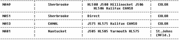
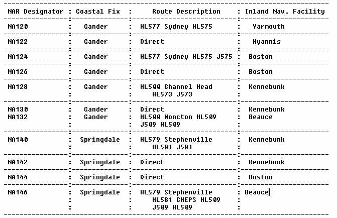
It is expected that current North Atlantic route (NAR) documentation will be carried on the flightdeck of each aircraft operating within the NAR system, including a description of the current NAR and the information contained in the current NAT/OTS message. The official NAR route descriptions are contained in both Canadian Ministry of Transportation (MOT) and U.S. FAA publications. The official FAA listing appears in the MM, issued annually and amended quarterly. Changes to the NAR routes are advertised in the biweekly publication "International Notices to Airmen." The following list divides the NAR route description into two sections according to the direction of the flight. Each section is subdivided according to route portion (common or noncommon). The common portion describes the NAR route between the costal fix and the inland navigational facility. The noncommon portion describes the route between the NAR route system airport being used and the inland navigational facility.
NAR EASTBOUND ROUTES - COMMON PORTION (FOR TRAINING PURPOSES ONLY -
NOT TO BE USED FOR NAVIGATION)
|
|
|
 |
 |
j. Navigation Equipment and Procedures. To meet specific requirements regarding overall navigational performance of equipment and procedures, installation and approval must be in accordance with applicable civil airworthiness requirements, with particular reference to the following:
(1) the primary equipment information displays must be visible to, and all controls usable by, the appropriate crewmembers while seated at their duty stations;
(2) warning of failures or malfunctions must be provided by visual or aural signals;
(3) the airborne system must be protected against power interruptions and/or abnormalities; and
(4) the equipment must not be the source of objectional radio frequency interference and must not be adversely affected by interference from other systems in the aircraft.
The operations manual must contain such pertinent material as required
to define all operational limitations associated with the system's performance.
For example, in the case of a station-referenced system, the manual would
include details of the areas where an adequate signal level may be received
or, in the case of an inertial system, any limitations of the system's
ground alignment and of the time period within which adequate navigational
performance within specified limits can be reasonably assured. Experience
has clearly demonstrated that the presence of sophisticated navigational
equipment on board an aircraft does not, by itself, ensure that a high
level of performance will be achieved. Two operators may have identical
equipment, suggesting that they would achieve similar performance. This
will not be the case unless the equipment is properly installed and maintained,
and correctly used by the operating crews. Therefore, it is essential to
provide adequate training for the personnel operating or maintaining the
equipment, and that mandatory operating drills and procedures are included
in crew training courses.
k. Sources of Navigation Errors. A significant proportion of navigation errors result from the use of incorrect data. To minimize the problem, source data must be clearly legible under the worst cockpit lighting situations and presented in a format suitable for error free use in the cockpit environment. On navigation (radio facility) charts, all position coordinates should ideally be printed in dark blue or black numerals against the white background. If coordinates would normally appear against a locally tinted background, they should be enclosed in a white box. Positively no information should be overprinted on top of position coordinates. If groups of position coordinates must appear in close proximity to each other, the position referenced by each set of coordinates should be clearly indicated by means of a leader. Navigational documents, such as track messages or flight plans, should be double spaced or boxed to minimize the possibility of line slippage when the information is read. It is advisable to provide pilots with a simple plotting chart of suitable scale (1 inch equal to 120 NM has been used successfully on NAT routes) in order to facilitate a visual presentation of an intended route that is otherwise defined only in terms of navigational coordinates. (For more details, see the NAT MNPS Airspace Operations Manual.) In parts of the NAT, Omega signals from the Liberia station can be badly affected by modal interference, especially at night along any part of the signal path. Consequently, when any other transmitters are shut down for reasons such as scheduled maintenance, Omega tracking problems can occur. For operations in MNPS airspace, it is generally accepted that the very low frequency (VLF) backup is advisable.
Errors involving aircraft equipped with Omega were discovered to be disproportionately high by the NAT Special Planning Group (SPG). No positive conclusion has been reached as to why the Omega gross navigation error (GNE) record is so poor, but implementation of the following suggestions is likely to lead to improvement. States of registry should ensure that their operators understand the importance of the strength of received signals. It is essential to choose the best antenna; to ensure, by careful skin mapping, that it is well located; and to check that there is no loss of efficiency at the antenna coupling as the result of inadequate drainage. The regular monitoring and logging of station signals and signal strength by the flightcrews will assist maintenance personnel in evaluations of the system's performance. Operators using Omega for MNPS operations will appreciate the need to provide crews with the latest information on the status of Omega and VLF transmissions. Omega equipped aircraft using E-field antennae are likely to suffer prolonged loss of signal reception when operating in or near clouds. Due to the recent improvement in Omega equipment and software, old equipment without updated software should not be purchased. If old equipment is still in use, every effort should be made to incorporate software modifications to achieve the best possible performance standards.
Several high power, nondirectional radio beacons (NDB) are located in
the NAT region that are useful to automatic direction finder (ADF) equipped
aircraft. Some of these stations, including commercial band transmitters,
are not monitored for outages or interference by transmitters on adjacent
frequencies and may be severely affected by atmospheric conditions. VHF
communications coverage extends to line-of-sight distance from facilities
in Canada, Iceland, Greenland, Faeroe Islands, the Azores, and coastal
Europe. The Canadian VHF coverage is extended by use of a remote facility
in southern Greenland. High frequency (HF) communications are available
throughout the NAT region for ATC purposes, and HF is mandatory for flight
within the Shanwick OCA. Use of HF by pilots of IGA flights permits proper
monitoring of the flight progress. HF equipped flights should be able to
receive HF VOLMET broadcasts, which contain continual updates on the meteorological
situation at major terminals in Europe and North America and significant
meteorological information (sigmet) warnings.
2. STATE RESPONSIBILITY.
It is implicit in the concept of MNPS that all operations within the airspace, whether by public transport or general aviation aircraft, achieve the highest standards of navigation performance accuracy. All flights within NAT MNPS airspace must have the approval of either the state of registry of the aircraft or the state of the operator. Such approvals encompass all aspects of the expected navigation performance accuracy of the aircraft, including the navigation equipment carried, installation and maintenance procedures, and crew navigation procedures and training. Due to local circumstances and varying national arrangements, procedures and methods employed for issuing approvals can vary considerably between states. As new operators apply to conduct operations in MNPS airspace, states not familiar with approvals should be able to draw on the experience of other states. It is essential to the integrity of the MNPS concept that knowledge is shared; therefore, states that have issued supplementary material are urged to make it available to ICAO.
3. PURPOSE AND CONCEPTS OF MNPS.
ICAO SARP for aircraft operation state that, for flights in defined portions of airspace where MNPS are prescribed, an airplane shall be provided with navigation equipment which continuously indicates to the flightcrew the aircraft's adherence to or departure from track to the required degree of accuracy at any point along that track, and which has been authorized by the state of the operator or the state of registry for the MNPS operations concerned. Since its inception in 1965, the North Atlantic Special Planning Group (NAT SPG) has been developing methods and procedures allied to the safe separation between aircraft on tracks in the NAT region. In 1975, the NAT SPG proposed establishing an MNPS for all aircraft using the North Atlantic Organized Track System (NAT OTS) to enable a reduction in the lateral separation minimums. The rationale and foundation for MNPS is based on a mathematical model that expresses the relationship between collision risk and separation. The integrity of MNPS airspace is maintained by a series of procedures that include approval of navigation equipment and its operation, along with continuous monitoring of the navigation accuracy by aircraft in MNPS airspace. It is essential to the application of the lateral separation minimums that all operations in MNPS airspace by public transport, IGA, and state aircraft achieve the highest standards of navigation performance accuracy. Some FAR Part 91 operators erroneously believe that, because they are not required to hold an air carrier certificate, they should not be subject to stringent separation requirements. This belief is incorrect; whenever an aircraft operating on the NAT OTS deviates from course, there will be another aircraft located 60 NM or less to either side of the assigned track. If a collision results from faulty procedures or any other reason, the results are equally catastrophic regardless of whether the offending aircraft is operated under FAR Part 91 or Part 121.
a. NAT MNPS. MNPS are applied to aircraft operating between FL 275 and 400 within the Shanwick, Gander, and Reykjavik OCAs; part of the New York OCA; and Santa Maria OCA. Continuous monitoring of the navigation accuracy of aircraft using MNPS; airspace is carried out by use of radars covering the exits from the airspace in order to confirm that the required navigation standard is being achieved. On the basis of such monitoring, it has been agreed by ICAO that the lateral separation minimum for aircraft operating in MNPS airspace shall be 60 NM. It is implicit in the concept of MNPS, and essential to the application of the quoted lateral separation minimum, that all operations in MNPS airspace achieve the highest standards of navigation performance accuracy. Checks are carried out from time to time to verify the approval status of aircraft operating within MNPS airspace. Aircraft that are approved for operations within the NAT MNPS airspace shall have navigation performance capability such that:
(1) the standard deviation of lateral track errors shall be less that 6.3 NM (11.7 km)
(2) the proportion of the total flight time spent by the aircraft 30
NM (55.6 km) or more off the cleared track shall be less than 5.3 by 10-4
(3) the proportion of the total flight time spent by aircraft between 50 and 70 NM (92.6 and 129.6 km) off the cleared track shall be less than 13 by 10-5
The MNPS shall be applicable in that volume of airspace defined on page 3-1 of this AC.
b. Application of MNPS. It is essential that stringent minimum navigation performance requirements be applied only to those route structures and localities where compliance is essential to safe and cost effective operation with minimum interference with the free movement of air traffic. Proposals for the adoption and enforcement of criteria in a particular region should take into account the effects of any new regulatory requirements on all operations to ensure that any exclusion of traffic from desirable tracks will be kept to a reasonable minimum, and that satisfactory alternate tracks with a lower density are available for excluded traffic. Navigation performance specifications must be formulated in a manner acceptable to both equipment manufacturers and aircraft operators. These specifications should define the maximum proportion of total flight time during which aircraft can be allowed to deviate specified distances. These specifications should apply for a period of at least 10 years after implementation. Specifications relating to the separation between routes will normally be determined by regional agreements based upon assessment of navigational performance in that area or on those routes. In most cases, route spacing is based on the known performance of the majority of existing traffic to ensure that a new navigational system can meet the specified criteria. Confirmation of compliance is likely to be a long term process, since the number of large errors that can be accepted is very low. Once performance criteria are established, continuous monitoring is needed to ensure that the required specifications and standards are maintained, and that there is no gradual erosion of safety standards. If the monitoring process shows that overall system performance is consistently better than the required navigation performance specifications, procedures may be adjusted to benefit the majority of users.
c. General Route Structure. As previously explained, much of the NAT traffic contributes to one of two flows: a westbound flow from Europe in the morning, and an eastbound flow from North America in the evening. The constraints of the necessary horizontal separation criteria and a limited economical height band (FL 310 - FL 390) make the airspace congested at peak hours. Airspace utilization is improved by strategic use of so-called "opposite direction" FLs; that is, FLs 310, 350, and 390 eastbound, and FLs 330 and 370 westbound during periods of peak flow. Utilization is further improved by the application of mach number technique, whereby aircraft operating successively along suitable routes maintain an appropriate mach number for a relevant portion of that flight. Experience has shown that when two or more aircraft operate on the same route at the same FL, use of the mach number technique is more likely to maintain constant longitudinal separation than other methods. When the variability of the weather is introduced, it becomes necessary to create a track structure that takes into account all known factors and offers operators a choice of economically viable routes as close as possible to the minimum time track (MTT). This variable track structure is the OTS. Figure 3-4 is an example of preferred routes for westbound NAT traffic.
d. Organized Track System. After determination of basic MTT's, with due consideration to airlines' preferred tracks and taking into account airspace restrictions such as danger areas and military airspace reservations, the OTS is constructed by the appropriate oceanic area control center (OAC). The nighttime (eastbound) OTS is constructed by the Gander OAC, and the daytime (westbound) by Shanwick OAC (Prestwick), each taking into account tracks that New York, Reykjavik and/or Santa Maria may require in their respective OACs. In each case, OAC planners consult each other, coordinate as necessary with adjacent OACs and domestic ATC agencies, and ensure that the proposed system is viable for lateral and vertical separation criteria. They also take into account the anticipated requirements of the opposite direction of traffic and ensure that sufficient track and FL profiles are provided to satisfy anticipated traffic demand. The impact on domestic route structures and the serviceability of transition area radars and navaids are checked before the OTS is finalized.
The agreed OTS is then promulgated as a NAT track message via the Aeronautical
Fixed Telecommunications Network (AFTN). A typical time of publication
of the westbound OTS is 0000 UTC, with the eastbound OTS at 1200 UTC. This
message gives full details of the OTS coordinates as well as the FLs that
are expected to be in use on each track. Correct interpretation of the
track message by operators and pilots is essential to both economy of operation
and in minimizing the possibility of misunderstanding leading to the use
of incorrect track coordinates. Oceanic airspace outside the published
OTS is available for random operations, subject to separation criteria
and NOTAM restrictions. Flights that do not operate on the OTS, or that
join or leave an organized track at some intermediate point, are considered
to be random operations.
e. Other Routes and Route Structures Within or Adjacent to NATMNPS. When NATMNPS airspace was introduced, it was recognized that some special procedures and routes were needed. Procedures were required for aircraft suffering partial loss of their full navigational capability, with consideration of those aircraft operating along a number of relatively short range routes within MNPS airspace. Further experience showed that account also had to be taken to cover aircraft not equipped with HF radio. Flights operating along these special routes still need state approval to operate within MNPS airspace.
f. Routes for Aircraft With Only One Long Range Navigation System. A number of special routes have been developed for aircraft equipped with only one long range navigation system (LRNS). These routes are within MNPS airspace, and state approval is required for operations in this airspace. Aircraft that are equipped with normal short range navigation equipment (VHF omnidirectional radio range (VOR)/distance measuring equipment (DME), ADF) and at least one fully operational set of one of the following types of navigational equipment:
* Doppler with computer
* Global Positioning System (GPS)
* inertial navigation system (INS)
* Omega
* Loran C (not applicable to all routes)
* flight management system/inertial reference system (FMS/IRS) Aircraft with this equipment are capable of meeting the MNPS while operating along the routes listed below:
NOTE: Routes (a) through (g), listed below, were known as "Blue Spruce"
routes and are now referred to as "special" routes. Continuous VHF coverage
exists on these routes at FL 300 and above except as noted.
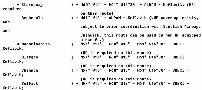 |
|
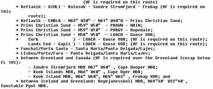 |
g. Routes for Aircraft with Short Range Navigation Equipment. The following
routes may be flown by aircraft with short range navigation equipment (VOR/DME,
ADF), but an LOA for operation within MNPS airspace is still necessary
(see below).
(1) Flesland - Myggenes - INGO - Keflavik (G3)
(2) Sumburgh - Akeraberg - Myggenes (G11)
h. Procedures for Aircraft Suffering Partial Loss of Navigation Capability Before Entry into MNPS Airspace. ICAO Annex 6, Parts I and II, Chapter 7 state that aircraft must be sufficiently provided with navigation equipment to ensure that, in the event of the failure of one item of equipment at any stage of flight, the remaining equipment will enable the aircraft to proceed in accordance with MNPS, requirements where applicable. For flight in NAT MNPS airspace, this is interpreted to mean that, while two sets of long range navigation equipment have to be carried when operating in the major part of the MNPS airspace, there are routes on which carriage of only one set each of long range and short range navigation equipment is required. If an aircraft suffers partial loss of navigation capability prior to entry into oceanic airspace (for example, only one INS or FMS/IRS is serviceable), the pilot should consider using one of the special routes listed above. Use of these routes following partial loss of navigation capability is subject to the following criteria:
(1) sufficient navigation capability remains to meet the MNPS; that is, one LRNS plus short range navigation aid;
(2) the requirements of ICAO Annex 6, Parts I and II, Chapter 7 with regard to the provision of navigation equipment necessary to enable the aircraft to be navigated in accordance with its operational flight plan and the requirements of ATS can be met by relying on the use of short range navigation aids in the event of failure of the remaining LRNS;
(3) a revised flight plan is filed with the appropriate ATS unit; and
(4) an appropriate ATC clearance is obtained.
NOTE: A revised oceanic ATC clearance will be issued after coordination between all OACs concerned. If the OTS extends to the northern part of the NAT region at the time of the incident, the aircraft may be required to accept a lower than optimum FL in its revised oceanic clearance, especially during peak traffic periods.
i. Special Provisions for Aircraft Not Equipped for Operation in MNPS Airspace to Climb or Descend Through MNPS Airspace. Some aircraft, particularly the higher performance IGA aircraft, operate at FL's above the upper limit of MNPS airspace (FL 410 and above). Depending on their point of departure, such aircraft often require a comparatively brief penetration of MNPS airspace. In order that non-MNPS equipped aircraft are not unduly penalized by being excluded from operating at their most economic cruising level, provisions are made for climb and descent through MNPS. The NAT SPG agreed to the following provisions on the understanding that these would be published in the relevant AIPs by the states concerned, stating the VOR/DMEs to be used and indicating those parts of the MNPS airspace which may be affected by this procedure. Aircraft not equipped for operation in MS airspace may be cleared by the responsible ATC unit to climb or descend through MNPS airspace provided:
(1) the climb or descent can be completed within the usable coverage of selected VOR/DME's and/or within the radar coverage of the ATC unit issuing such clearance;
(2) the aircraft is able to maintain direct pilot-controller communications on VHF; and
(3) MNPS aircraft operating in that part of the MNPS airspace affected by such climb or descent are not penalized by the application of this procedure.
4. OPERATIONAL APPROVAL TO FLY IN MNPS AND/OR RVSM AIRSPACE.
a. Methods of Approval. In the United States, operational approval to fly in MNPS and/or RVSM airspace is obtained by the issuance of operations specifications for certificated operators or by issuance of an LOA to noncertificated operators. Previously, LOAs (called certificates by ATC and foreign governments) have been nonstandard, have not had an expiration date, and were not crew specific in spite of ICAO regulations requiring that crews be trained to operate in MNPS airspace. Upon publication of this AC and guidance to FAA inspectors, the following changes will be enacted:
(1) LOAs will be standardized as per the format shown in Figure 3-5.
(2) LOAs will have a 24 calendar months validity period.
(3) Current holders of an LOA will be required to obtain a new LOA by October 1, 1996. A new LOA can be obtained in person or by mail by surrendering the old LOA and submitting a letter in the format shown in Figure 3-6 and a completed LOA letter in the format shown in Figure 3-5.
(4) Operators applying for an initial LOA can expect the following from the FAA inspector handling their request:
(a) inspection of navigation equipment installation;
(b) verification that the aircraft has the required communication and navigation equipment for operations in MNPS airspace; and
(c) verification that crews that will fly the aircraft and/or flight departments responsible for MNPS crews have the qualifications to use the navigation and communication equipment installed in the aircraft. If the inspector determines that a flight department and/or crew does not have adequate qualifications, a proving run will be required. Qualifications may be acquired by various methods. It is recommended that crews receive training from either a commercially conducted oceanic procedures course or a course conducted by their flight training department, and not depend solely on the self-study of oceanic procedures.
(d) The inspector will verify that the aircraft is a U.S. registered aircraft, properly registered under the provisions of FAR Part 47. Inspectors will need assurance that aircraft registered to corporations have the name and address (not Post Office box) of an individual U.S. citizen responsible for crew(s) performance in MNPS airspace.
(5) All LOAs will be assigned a unique tracking number by the issuing office, and will be valid for 24 months. (ATC and/or foreign ATS may request the number and date of the LOA). Renewal of the LOAs will follow the same procedure as outlined in paragraph 3, above, if the aircraft's equipment has not changed since the issuance of the previous LOA. If new equipment has been installed, a new application for an LOA must be made in the same manner as that required for the initial LOA. The LOA must be carried in the aircraft at all times when operating in MNPS airspace.
b. Installation Approvals. In most cases, operators will be able to
select navigation equipment with established performance capability. When
a new system is proposed or major changes have been made in an existing
system, an evaluation will be required to establish the quality of performance
before authorization for use as a primary system. (Detailed information
on proving and validation flights is contained in Chapter 8 of this AC.)
Before an installation can be approved and authorized as a primary navigation
system, an FAA avionics inspector must ascertain the approval status of
the installed LRNS equipment by review of the aircraft records to determine
the basis for LRNS installation.
FIGURE 3-5. FORMAT FOR AN LOA TO OPERATE IN THE NAT MNPS
This letter constitutes approval for the named aircraft to operate in the North Atlantic Minimum Performance Specification Airspace (NAT MNPS) and/or Reduced Vertical Separation Minimum (RVSM) airspace or to conduct oceanic flight by the authorized operator or crew listed under the conditions and limitations below.
Aircraft make and model ______________________ N-Number ______________________
Aircraft serial number _________________________ Aircraft color _____________________
NAVIGATION EQUIPMENT
TYPE/MANUFACTURER/MODEL PART NUMBER DATE INSTALLED
_______________________________________________________________________________________
_______________________________________________________________________________________
_______________________________________________________________________________________
COMMUNICATION EQUIPMENT
TYPE/MANUFACTURER/MODEL PART NUMBER DATE INSTALLED
_______________________________________________________________________________________
_______________________________________________________________________________________
_______________________________________________________________________________________
Aircraft base of operations (city, state, zip) ______________________________________________________
Name of aircraft owner/operator______________________________________________________________
Crew training conducted by _________________________________________________________________
Print name of person responsible for crew operations or agent for
service (must be a U.S. citizen) _________________________________
Signature of person responsible for crew operations or agent for
service ____________________________________________________
Street address (cannot be a Post Office box) ________________________________________________
City, state, zip code ___________________________________________________________________
FOR FAA USE ONLY (To be completed by issuing office)
This approval is for: MNPS only ____________________ MNPS and RVSM ____________________
Authorization Number _________________________________
Aircraft limitations (if applicable) ______________________________________________________________
Program Tracking and Reporting Subsystem (PTRS) tracking number ________________________
Date of Issuance ____________________ Expiration Date _________________________
This authorization is subject to the conditions that all operations conducted within NAT MNPS airspace are in accordance with FAR Sec. 91.705 and the flight rules contained in International Civil Aviation Organization (ICAO) Annex 2, and that all operations outside of the United States comply with FAR Sec. 91.703 and Annex 2. The person responsible for crew operations or agent for service must accept responsibility for complying with the stated regulations by signing this document. This document is considered invalid until signed. If the person signing this document relinquishes responsibility, changes mailing address, or the aircraft changes ownership or base of operation, this letter becomes invalid and the signee should immediately notify the issuing office of the change. LOAs can be renewed via a letter or fax request submitted at least 30 days prior to the expiration date if no changes have been made. If any changes have been made, application for a new LOA must be made in the same manner as that required for the initial LOA.
_________________________________________
Office Manager's Signature
FIGURE 3-6. FORMAT FOR LETTER TO RENEW LOA
FROM: [person or department requesting LOA]
[company name (if applicable)]
[street address] (PO Box not acceptable)
[city, state, zip code]
TO: Federal Aviation Administration (FAA)
Flight Standards District Office
[street address]
[city, state, zip]
Dear Inspector:
Enclosed is an expired Letter of Authorization (LOA) and a completed form requesting a new LOA for operations in Minimum Navigation Performance Specification and/or Reduced Vertical Separation Minimum airspace. [Format for LOA is in Figure 3-5 of this Chapter.]
I/we certify than any changes that have taken place since the expired LOA was issued are reflected on the attached LOA form. I/we further certify that I/we have obtained a copy of the Oceanic Operations advisory circular, and are familiar with its contents.
Sincerely,
[person's signature responsible for crew operations or agent for service]
[typed name of person responsible for crew operations or agent for service]
[title]
[date]
NOTE: The letter should be sent to the office that issued expired LOA.
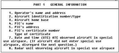
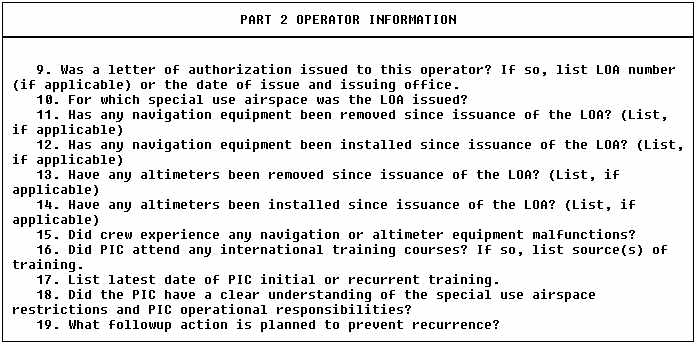
FIGURE 3-7. INVESTIGATIVE REPORT FOR SPECIAL USE AIRSPACE LOA
It is an FAA responsibility to reply to the North Atlantic Central Monitoring
Agency (NAT CMA) whenever an operator is suspected of not having authorization
or of having improper authorization to fly in special use airspace. Routine
(random) monitoring may also be the reason for initiation of a request
to verify special use airspace authorization. The following form will be
used by Aviation Safety Inspectors (ASI) to investigate alleged operations
into MNPS airspace without authorization or with improper authorization.
The form is included in this AC to alert operators that operations in MNPS
airspace will be strictly monitored and to advise operators of the investigative
responsibilities of ASIs.
 |
|
 |
 |
|
 |
(2) The operator must furnish proper aircraft documentation showing the approval basis of the installation. The original equipment list, which may be the basis for compliance with the aircraft type certificate (TC), and FAA Form 337, "Major Repairs and Major Alterations," showing compliance with an appropriate aircraft supplemental type certificate (STC) or FAA field approval.
(3) If the LRNS equipment has met the accuracy requirements of FAR Part 91, Appendix C as determined by the manufacturer during certification flight tests in MNPS in conjunction with the appropriate aircraft certification office (ACO), the limitations section of the flight manual supplement will state that the particular LRNS equipment is authorized for use in NAT MNPS. If that authorization is not found in the limitations section, the request for approval to operate in MNPS airspace will be denied.
c. Acceptable Means of Compliance. In developing the MNPS concept, it was recognized that an indication of an "adequate means of compliance" would be needed, with specifications in terms of aircraft equipment. However, equipment specifications are only one part of the total quality of performance required. Flightcrews must be qualified for oceanic operations and be specifically qualified to operate under the rigid demands of the NAT MNPS airspace rules. The operator may prepare an international operations procedures manual, or may incorporate those procedures as a separate chapter of the Aircraft Operations Manual. In either case, the information must be accessible to the flightcrew. The manual should include specific preflight, inflight, and post flight procedures. It should specify the crewmembers responsible for waypoint insertion and verification, the waypoint coordinates source, and procedures for waypoint insertion and verification. Much of this information will depend upon the type of LRNS equipment in use. Procedures for recording equipment accuracy should be included. An actual log should be depicted in the manual, and a sample log page submitted with the application for the LOA. Additionally, plotting chart procedures should be included in the manual and a completed sample chart should be submitted. An LRNS checklist that includes LRNS equipment failure procedures should be incorporated with the regular aircraft checklists.
d. Navigational Requirements. There are two navigational requirements for aircraft planning to operate in NAT MNPS airspace. One refers to track-keeping accuracy, and the second refers to stand-by equipment with comparable performance characteristics (refer to ICAO Annex 6 Parts I and II, Chapter 7). To justify consideration for state approval for unrestricted operation in NAT MNPS airspace, an aircraft needs to be equipped with two fully serviceable LRNSs. It is not satisfactory for NAT MNPS operations to rely on intermittent updates of aircraft position. The standards require navigation equipment that continuously indicates to the flightcrew the aircraft's adherence to or departure from track, to the required degree of accuracy, at any point along that track. Thus, it is highly desirable, and probably essential, that the navigation system in use is coupled to the autopilot so that continuous steering guidance is provided.
e. INS, Inertial Sensor System (ISS), IRS, and Flight Management Control System (FMCS) Equipment. Extensive experience has been gained, both in the NAT region and on a world-wide basis, in the use of INSs, ISS, IRSs, and FMCSs. INS and ISS/IRS, when coupled with a FMCS for automatic flight guidance, have clearly demonstrated a capability to meet the MNPS. Some smaller aircraft may carry two IRSs (or ISS), but only one FMCS. Such an arrangement may meet track keeping parameters, but does not provide the required redundancy (in terms of continuous indication of position relative to track or of automatic steering guidance) should the FMCS fail. If failure occurs, dual FMCSs are required to obtain MNPS certification. INS is considered to be an LRNS. An FMCS with inputs from one or more IRSASS is considered an LRNS.
f. Omega Navigation System (ONS). Omega/VLF navigation systems are capable of satisfying the MNPS and have demonstrated levels of accuracy comparable to INS. However, monitoring of navigation performance in the NAT region has shown that the number of GNEs attributable to Omega equipped aircraft is disproportionately high when compared to INS equipped aircraft. Advice from the Omega Association suggests that many GNEs result from faulty positioning and installation of antennae, inadequate maintenance, and the use of old, unmodified equipment. States need to pay particular attention to these issues before granting MNPS approval to aircraft equipped with Omega. An ONS is considered to be a LRNS. An FMCS with inputs from one or more Omega sensor systems (OSS) is considered to be a LRNS. (Further information on Omega is contained in Chapter 8.)
g. Loran C Equipment. Loran C equipment with an integral navigation computer has an acceptable performance accuracy, but use of this equipment entails limited MNPS approval. Aircraft operations are restricted to routes where unambiguous ground wave cover is available (see Loran C coverage diagrams in Appendix 2).
h. Doppler Equipment. The use of Doppler equipment capable of displaying drift, groundspeed, and crosstrack error has been approved, on occasions, in conjunction with single INS, Omega, or Omega/VLF for operations in NAT MNPS airspace. However, such approvals are considered to be at the lowest acceptable level of navigation suitable for MNPS airspace. Doppler requires that continuous attention be paid to inflight rating of, and compensation for, systematic errors to guard against failure of the other single aid. Thus, installation of Doppler radar plus one other LRNS cannot be recommended for unrestricted MNPS operations.
i. GPS. GPS technology is changing rapidly; therefore, FAA GPS policies and procedures are also changing. Chapter 8 of this AC, at the time of publication, contains the latest GPS guidance; however, operators should be advised that the most recent GPS information will be distributed through, other FAA documentation that is published more frequently.
j. Summary. For state approval of unrestricted operations in MNPS airspace, an aircraft is required to be equipped with two fully serviceable LRNSs. An LRNS may be an INS, an ONS, or an FMCS with inputs from one or more IRS or ONS. Each LRNS must be capable of providing a continuous indication to the flightcrew of the aircraft's position relative to track. It is highly desirable, and probably essential, that the navigation system employed for the provisions of steering guidance is capable of being coupled to the autopilot.
5. RVSM - ADDITIONAL CONSIDERATIONS FOR APPROVAL
a. General. Airspace where RVSM is applied should be considered special use airspace. Both the individual operator and the specific aircraft type or types which the operator intends to use should be approved by the appropriate FSDO before the operator conducts flights in RVSM airspace. Draft AC 91-RVSM, "Approval of Aircraft and Operators for Light in Airspace Above FL 290 Where a 1,000 Foot Vertical Separation is Applied," is scheduled for publication in late 1993. This document will provide specific guidance for the approval of aircraft types for flight in airspace where RVSM is applied.
b. Approval of Aircraft. Each aircraft type that an operator intends to use in RVSM airspace should have received FAA approval in accordance with AC 91-RVSM. The specific airworthiness approval process and the continued airworthiness maintenance requirements will be detailed in AC 91-RVSM. Operational approval is described in the following paragraph.
c. Operational Approval. Section 4 of this Chapter describes in general the administrative process which an operator should follow to receive approval or to renew a LOA to operate an aircraft in RVSM airspace. The FSDO to which an application for approval has been submitted must be satisfied that operational programs are adequate. Flightcrew qualifications as well as operation manuals will be evaluated. Approvals will be granted through the issuance of operation specifications or the issuance of an LOA. Further approval will be granted for each individual aircraft group utilized by an operator. The FSDO will ensure that each operator can maintain high levels of height- keeping performance. Details of these standards can be found in AC 91-RVSM.
d. Preapplication Meeting. A preapplication meeting should be scheduled
between the operator and the certificate management office (CMO) or FSDO.
The intent of this meeting is to inform the operator of FAA expectations
in regard to approval to operate in a RVSM environment. The content of
the operator RVSM application, FAA review and evaluation, validation flight
requirements, and conditions for removal of RVSM authority should be basic
items of discussion.
e. Content of Operator RVSM Application. The following paragraphs describes the material which an operator applying for RVSM authority should provide to the FAA for review and evaluation at least 60 days prior to the intended start of RVSM operations.
f. Application Form. Figure 3-5 is an acceptable format for a LOA. This figure may be copied and the top section down to the "For FAA Use Only" section filled out by the operator.
g. Airworthiness Documents. Sufficient documentation must be available to show that the aircraft has been approved by appropriate airworthiness authorities.
h. Description of Aircraft Equipment. A description of the aircraft equipment appropriate to operations in an RVSM environment should be included on the application form.
i. Training Programs and Operating Practice and Procedures. FAR Part 121 and FAR Part 135 operators should submit training syllabuses and other appropriate material to the certificate-holding district office (CHDO) or FSDO to show that the operating practices, procedures, and training items related to RVSM operations are appropriately incorporated in initial and recurrent training programs. FAR Part 91 operators must demonstrate to the FSDO that their knowledge of RVSM operating practices, procedures and qualifications is equivalent to FAR Part 121 and FAR Part 135 operators and is sufficient to warrant the granting of an LOA to conduct RVSM operations. Practice and procedural training in the areas listed in Chapter 10 of this AC should be standardized along with the specific guidelines that follow.
(1) During flight planning, the flightcrew should pay particular attention to conditions which may affect operation in RVSM airspace. These include, but may not be limited to:
(a) reported and forecast weather conditions on the route of flight
(b) minimum equipment requirements pertaining to height keeping systems
(2) The following specific actions should be accomplished during preflight:
(a) Review maintenance logs and forms to ascertain the condition of equipment required for flight in the RVSM airspace. Ensure that maintenance action has been taken to correct defects to required equipment.
(b) During the external inspection of aircraft, particular attention should be paid to the condition of static sources and the fuselage skin in the vicinity of each static source, and of any other component that affects altimeter system accuracy. This check may be accomplished by a qualified and authorized person other than the pilot; for example, a flight engineer or maintenance personnel.
(c) Before takeoff, the aircraft altimeters should be set to the local altimeter (QNH) setting and should display a known elevation (for example, field elevation) within the limits specified in the aircraft's operating manuals. The two primary altimeters should also agree within limits specified by the aircraft's operating manual. An alternate procedure using airport altitude (QFE) may also be used. In either case, the maximum deviation value for the checks cited in operating manuals should not exceed 75 feet.
(d) Before takeoff, equipment required for flight in RVSM airspace should be operative, and indications of malfunctions should be resolved.
(3) Before entering RVSM airspace, the pilot should review the status of required equipment. Should any of the required equipment fail prior to entering RVSM airspace, the pilot should request a new clearance so as to avoid flight in this airspace. The following equipment should be operating normally:
(a) two primary altitude measurement systems
(b) one automatic altitude control system
(c) one altitude alerting device
NOTE: Redundancy requirements for altitude control systems should be established by regional agreement after an evaluation of criteria such as mean time between failures, length of flight segments, and availability of direct pilot-controller communications and radar surveillance. An operating transponder may not be required for entry into all designated RVSM airspaces. The operator should determine the requirements for an operational transponder in each RVSM area where operations are intended. The operator should also determine the transponder requirements for transition areas adjacent to RVSM airspace.
(4) The following actions should be accomplished while inflight:
(a) Emphasis should be placed on promptly setting the subscale on all primary and standby altimeters to 29.92" Hg/1013.2 hPa when passing the transition altitude and rechecking for proper altimeter setting when reaching the initial cleared flight level (CFL).
(b) In level cruise, it is essential that the aircraft is flown at the CFL. This requires that particular care is taken to ensure that ATC clearances are fully understood and followed. Except in contingency or emergency situations, the aircraft should not intentionally depart from CFL without a positive clearance from ATC.
(c) During cleared transition between levels, the aircraft should not be allowed to overshoot or undershoot the old or new FL by more than 150 feet (45 meters).
NOTE: It is recommended that the level off be accomplished using the altitude capture feature of the automatic altitude-control system, if installed.
(d) An automatic altitude control system should be operative and engaged during level cruise, except when circumstances such as the need to retrim the aircraft or turbulence require disengagement. In any event, adherence to cruise altitude should be done by reference to one of the two primary altimeters.
(e) The altitude alerting system should be operative.
(f) At intervals of approximately 1 hour, cross-checks between the primary altimeter should be made. A minimum of two must agree within ± 200 feet (± 60 meters). Failure to meet this condition will require that the altimetry system be reported and that ATC be notified.
(g) For flights conducted in oceanic/remote areas, the hourly altimeter cross-check should include comparing the primary altimeters to the standby altimeter. This information, can be useful in contingency situations, such as when a spread/split between primary altimeters or altimeter system malfunctions occurs.
(h) The operating altitude reporting transponder should be connected to the altimetry system being used to control the aircraft.
(i) If the pilot is advised in real time that the air-craft has been identified by a height monitoring system as exhibiting a total vertical error (TVE) greater than ± 300 feet (± 90 meters) and/or altitude system error (ASE) greater than ± 245 feet (± 75 meters), then the pilot should follow established regional procedures to protect the safe operation of the aircraft. (This assumes that the monitoring system will identify TVE or ASE within agreed levels of accuracy and confidence.)
(j) If the pilot is notified by ATC of an assigned altitude deviation (AAD) error which exceeds 300 feet (± 90 meters), the pilot should take action to return to the CFL as quickly as possible.
j. Contingency Procedures After Entering RVSM Airspace. The pilot should notify ATC of contingencies which affect the ability to maintain the CFL and coordinate a plan of action. Section 6 of this Chapter contains detailed guidance for contingency procedures for NAT airspace. Examples of equipment failure that should be reported to ATC include the following:
(1) failure of all automatic altitude control systems aboard the aircraft;
(2) loss of redundancy of altimetry systems, or any part of these, aboard the aircraft;
(3) loss of thrust on an engine necessitating descent; and
(4) any other equipment failure affecting the ability to maintain CFL.
The pilot should notify ATC when encountering greater than moderate turbulence. If unable to notify ATC and obtain an ATC clearance prior to deviating from the assigned CFL, the pilot should follow established contingency procedures to leave the assigned route or track and obtain ATC clearance as soon as possible.
k. Flightcrew Training. Chapter 10 of this AC details crew training for oceanic operations.
6. SPECIFIC CONTINGENCY PROCEDURES FOR THE NAT AIRSPACE.
a. Background. If a pilot is unsure of the vertical or lateral position of the aircraft, or if the aircraft deviates from its assigned altitude or track for cause without prior ATC clearance, the pilot must take action to mitigate the potential for collision with aircraft on adjacent routes or FLs. In this situation, the pilot should alert adjacent aircraft by making maximum use of aircraft lighting and by broadcasting position, FL, and intentions on 121.5 megahertz (MHz). Unless the nature of the contingency dictates otherwise, the pilot should advise ATC as soon as possible of a contingency situation and request an ATC clearance before deviating from the assigned route or FL if possible. If a revised ATC clearance cannot be obtained in a timely manner and action is required to avoid potential conflict with other aircraft, then the aircraft should be flown at an altitude and/or track where other aircraft are least likely to be encountered. This can be accomplished by offsetting from routes or altitudes normally flown in the airspace. In order of preference, these are the following actions:
* The pilot may offset half the lateral distance between routes or tracks.
* The pilot may offset half the vertical distance between altitude normally flown.
* The pilot may also consider descending below FL 285 or climbing above FL 410 (these altitudes are sparsely occupied).
When executing a contingency maneuver, the pilot should perform the following:
* watch for conflicting traffic;
* continue to alert other aircraft using 121.5 MHz and aircraft lights;
* continue to fly tracks or altitudes which are likely to be occupied; and
* obtain an ATC clearance as soon as possible.
7. THE MONITORING PROCESS IN THE NAT REGION.
a. Introduction. Radar stations that monitor NAT oceanic airspace boundaries collect data that includes information on MNPS airspace flights derived from agreed radar stations and data from other radars concerning non-MNPS airspace flights. The MNPS data gives direct input into the risk modelling of the MNPS airspace, while the non-MNPS data provides a wider understanding of navigation in the NAT region and allows followup action to be taken on a larger number of flights that are believed to have had a navigation error. The data collection process includes continuous collection of all deviations of 20 Nm or more, and collection of data on deviations of less than 20 NM as required.
b. Central Monitoring Agency (CMA). In March 1980, the NAT SPG realized that implementation of the 60 NM lateral separation minimum would place special importance on the monitoring and assessment of navigation performance. Therefore, the SPG agreed to collect, collate and circulate data regarding navigation performance in the NAT region to states participating in the monitoring. The United Kingdom acts as CMA on behalf of the NAT SPG and has accepted responsibility for the collection, analysis, and dissemination of data relevant to navigation specifications. Information received includes the following:
(1) monthly routine reports (from Canada and the United Kingdom) on the number of MNPS flight operations, both OTS and random;
(2) reports of GNEs observed by radar supplemented by information on causes, responses by operators and/or states, and the corrective action taken; and
(3) information on errors not observed by radar that became known by other means or from other sources.
The reports of errors not observed by radar are recorded because their inclusion and investigation can provide useful information, particularly in respect to errors and/or omissions resulting from non-compliance with the prescribed position reporting procedures, errors resulting from misunderstandings of clearances, and/or differences in interpretations between pilots and ATC regarding instructions passed. The CMA provides participating states with a monthly summary so that they may be kept current on overall developments. The CMA also provides special reports as necessary to enable states to decide on a common course of action.
c. Deviations from Track. If a deviation of 20 NM or more from assigned track is observed by radar, it is important that the pilot is immediately advised and that any comment is recorded. Followup action includes notification of the operator, the operator's state of registry, and the CMA. The appropriate authority of the state that collected the data will investigate the causes of each deviation, either directly or through the CMA, in cooperation with the operator. That agency also notifies the operator's state of registry. Such a procedure is used by Canada, France, Iceland, Ireland and the United Kingdom. All information about detected deviations and their causes, as well as any other information relating to navigation performance within the NAT region, is made available to the NAT SPG by the CMA. The data is provided on a monthly basis in a format permitting ready determination of whether MNPS criteria are being met. Such analysis is made of all available data to determine overall safety. Analysis is also made of data concerning specific navigation systems or operators, if it is suspected that they may no longer meet the specification.
If one or more of the MNPS criteria have been exceeded, the NAT SPG reviews the data and, if necessary, proposes appropriate action. There are at least two general classes of errors that can result in large lateral deviations. One of these concerns a progressive deviation from track because of navigation inaccuracy, and the other covers cases when an aircraft flies to or along a track adjacent to its intended track as the result of an operational error. The second type, though extremely dangerous, cannot be prevented by increasing the lateral separation but must be eliminated by improvements to the operating procedures.
If summary statistics indicate that the MNPS criteria are greatly exceeded, rapid response to the causes of the problems may be necessary. In such a case, the states responsible for ATC in the NAT region will take prompt action after consultation with at least the major affected users. An example of when such prompt action may be necessary is a serious disturbance of the coverage of station-referenced systems due to unserviceability of ground stations or severe ionospheric disturbances. Such action must be possible even when the number of large deviations in the limited area where the navigation performance is monitored is not excessive and if there is a reason to believe that large errors might occur elsewhere.
When the summary statistics show that the criteria have not been greatly exceeded, or if the observed performance merely shows a trend towards degradation, it will be more useful to conduct a detailed investigation, for instance by the NAT SPG. Although this may take several months, it must be remembered that the TLS is equivalent to expecting about one collision every 150 years, and that a small increase in the statistical probability of collision during a 6 or 12 months period is considered acceptable. An investigation may show that the cause of a large deviation can be eliminated by improved procedures, which will then be brought to the attention of the operators and/or ATC through the appropriate channels. Results of the actions will then be closely observed. If the causes cannot be eliminated quickly, the aircraft's state(s) of registry should temporarily exclude offending operators from MNPS airspace. In order to restore the situation, an increase in lateral separation should be made only in extreme cases and only when other actions have failed to produce the desired results. It is important that all agencies react promptly to reports of radar-based deviations. Investigation should begin at once so that consideration can be given to the need for remedial action (equipment improvements, crew training, etc.), especially if a specific trend becomes evident. In order for the deviation reports to receive prompt study, it would be prudent for each airline/operator to designate an individual to be responsible for receiving reports and initiating investigations. This individual's name and address should be made available to the appropriate ATC authorities.
Experience with the monitoring process shows that a number of the observed GNEs are attributable to aircraft operating in MNPS airspace without the required approval. For this reason, ATC units have been requested to notify the CMA of any flights, identified as a result of random checks, that operated in MNPS airspace but are considered unauthorized for that operation. In 1990, to reinforce the random checks, the NAT SPG introduced a program of tactical monitoring to help identify aircraft operating within MNPS airspace without the required approval. Currently Canada, Iceland and the United Kingdom participate in the program by selectively asking pilots requesting clearance to enter NAT MNPS airspace to confirm that they have been approved for that operation. Pilots unable to confirm, or uncertain of their approval status, are issued a clearance to operate outside MNPS airspace and a report is forwarded to the CMA for followup.
d. Followup of Observed and Reported Deviations. Different arrangements exist within those states participating in monitoring, but followup action on observed deviations of 20 NM or more by aircraft operating within MNPS airspace generally includes the following steps:
(1) the observing ATC unit should, if at all possible, inform the pilot of the observed error, that an error report will be processed, and record any comment made by the pilot at the time of notification; and
(2) all operators and relevant ATC units should be notified of the deviation, either directly by the observing ATC unit or by an agency designated by the state, by the speediest means available (telephone, AFTN, telex) and with the least possible delay.
When a U.S. registered aircraft that is not clearly identified as an air carrier or military operator is involved in a deviation, a copy of the initial error signal should be sent to the company/agency that submitted the ICAO flight plan. The full flight plan details and the name of the PIC should then be forwarded to the Federal Aviation Administration, Flight Standards National Field Office, AFS-550, PO Box 20034, Washington, DC 20041.
For aircraft operating outside MNPS airspace:
(1) the observing ATC unit should, if at all possible, inform the pilot of the observed error, that an error report will be processed, and record any comment made by the pilot at the time of notification; and
(2) if the observed deviation from track is 50 NM or more, all operators and relevant ATC units should be notified of the deviation, either directly by the observing ATC unit or by an agency designated by the state, by the speediest means available (telephone, AFTN, telex) and with the least possible delay. This should be followed as soon as possible by a written confirmation. All notifications should be copied to the CMA and the operator's state of registry.
(3) If the observed deviation from track is 20 NM or more but less than 50 NM, the observing ATC unit, or other agency designated by the state, should notify the CMA of the deviation with the least possible delay (telephone, AFTN, telex). This should be followed as soon as possible by a written confirmation if necessary. The CMA will advise the state of registry.
e. Additional Reports to CMA. Whenever possible, details of the following occurrences should be reported to the CMA. Any erosion of the longitudinal separation between aircraft in MNPS airspace in excess of 3 minutes, altitude deviations of 300 feet or more, as observed on radar (Mode 'C' SSR) or by scrutiny of pilot reports (see Figure 1-4, Appendix 1), or any occasion when ATC takes action to prevent a GNE should be reported.
f. Further Followup by Operator and/or State. Subsequent followup on observed deviations of 20 NM or more, reported in accordance with the above provisions, should initially be conducted between the operator and a designated state agency responsible for the ATC unit that observed the deviation, on the understanding that:
(1) deviations of 20 NM or more but less than 50 NM, occurring outside MNPS airspace, will not normally require further action. If an investigation is deemed necessary it will be conducted by the state of registry;
(2) monitoring states may request the assistance of other states in monitoring activities;
(3) the operator's state of registry should be requested to conduct a further investigation if deemed necessary;
(4) all correspondence should be copied and forwarded to the CMA; and
(5) the European office of ICAO will assist in those cases when no response is obtained from either the operator or the state of registry.
When a GNE in MNPS airspace is observed by ATC, crews shall provide
the controlling authority with detailed information on the cause of the
error, including LOA number and expiration date, upon request. This information
is not necessarily for the purpose of enforcement. In many cases, equipment
errors and/ or procedural errors caused the error, and investigators are
able to work with crews to eliminate future occurrences. The type of data
needed for an Oceanic Navigation Error Report (ONER) is listed in Figure
3-8. Pilots will be required to provide ATC with most of this information,
and should be prepared to do so when operating in MNPS airspace. Most of
the information should be contained in the flight journal for each flight
in MNPS airspace, and will always be available. Altitude deviations, erosion
of longitudinal separation, and requests for verification of LOA's may
also require investigations. All of these investigations are similar to
an investigation of a GNE. Therefore, crews must provide the controlling
authority with detailed information on these deviations in a similar manner.
FIGURE 3-8. OCEANIC NAVIGATION ERROR REPORT
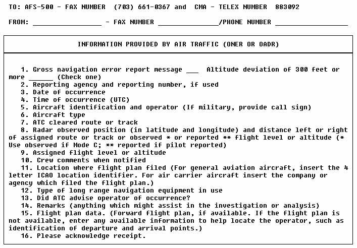 |
FIGURE 3-8. OCEANIC NAVIGATION ERROR REPORT
- Continued
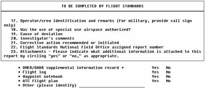 |
FIGURE 3-9. OCEANIC ALTITUDE DEVIATION REPORT
 |
FIGURE 3-9. OCEANIC ALTITUDE DEVIATION REPORT - Continued
 |
8. AIRCRAFT EQUIPMENT AND Inflight OPERATING PROCEDURES IN MNPS AIRSPACE.
a. Introduction. Good operating practices in navigation are essential to application of the MNPS concept. Fundamental differences exist between navigation systems, but the basic procedures for their application have much in common. Most Omega flightdeck displays have intentionally been designed so that controls and information displays resemble INS as much as possible. In this AC, "Omega" refers to automatic equipment that meets the ARINC 580-599 specifications. Equipment that requires manual correction or plotting to determine position increases flightcrew workload and the possibility of error, and is not recommended for use in normal operations.
b. Cockpit Layout and Equipment Installation. Efficient operation and monitoring of the aircraft navigation system is enhanced if careful consideration is given to the location of the system components in the cockpit and to the various features provided. Control display units (CDU) should be within the primary visual scan of, and conveniently accessible to, either pilot. This places them forward and inboard of each pilot. CDUs should not be mounted on the overhead panel or on the aft portion of the central pedestal (that is, to the side or rear of the pilot), nor should they be located outboard of each pilot. Retrofit costs and considerations should not override optimum location of the CDUs.
During navigation of the aircraft, it has become customary to display certain critical navigation system outputs continuously, such as crosstrack error (XTK) and miles-to-go to next waypoint.
These outputs are displayed on the panel mounted radio navigation indicators, with a switch to permit selection of ADF/VOR or INS/ONS. Some operators recommend that present position be displayed on the steering CDU (either INS or ONS) and XTK miles on the other.
Flight progress alert lights should also be provided on the instrument panel. The waypoint alert light, to indicate that the waypoint is being approached, is standard. However, consideration should also be given to the installation of a XTK alert light, triggered to indicate a deviation such as 6 - 10 NM of XTK deviation. If the navigation system is inadvertently decoupled from the autopilot, such a light provides an early warning of XTK error. Also, some form of autopilot status light could be considered (for example, green when coupled to the navigation system, red when uncoupled). The monitoring process has shown that errors occur because of the INS/ONS being inadvertently disconnected from the autopilot. There are problems in modifying existing equipment, but a crosstrack warning system would be useful. Operators placing orders for new equipment should discuss this possibility with the manufacturer.
Navigation equipment should be protected from damage. Fluids can very easily cause damage; CDUs in particular should be protected from spilled beverages, and all component parts should be protected from moisture. A good standard of INS maintenance is important; a poor standard, or the approval of a regime which permits many inflight failures, may not be cost effective because of the expensive difficulties which can result. It is preferable not to locate equipment in baggage holds, but if this cannot be avoided it requires protection against jarring and crushing. Care should be taken to prevent freight or baggage obstructing the ventilation of navigation units. Ventilation is an essential part of the cooling required for INS, Omega and Doppler equipment. The greatest problem is to provide adequate cooling of the equipment after the aircraft has been heat soaked while parked at a tropical airport. Adequate cooling is likely to be needed most of the time, so cooling facilities and warning of their failure are necessary.
c. Training. Whether using INS or ONS, crews need proper training. In the case of Omega, experience suggests more extensive training is necessary to ensure that crews have a general understanding of problems that may be encountered inflight. INS and Omega, because of their precision and reliability, can induce a sense of complacency that tends to obscure the value of standard procedures, especially cross-checks. Under these circumstances, errors occur more easily. Special training programs for flightcrews using Omega should include efficient use of the equipment and indoctrination in the necessity and methods of avoiding errors. Crewmembers should be trained to develop a meticulous method of using CDUs, with careful cross-checking at all operational stages, in line with the procedures described in the NAT MNPS Operations Manual.
The operator should seek to retain the interest and cooperation of flightcrews in ensuring that a good standard of navigation performance is continuously maintained. This may be achieved during ground refresher courses, periodic routine checks, or by issuing periodic newsletters. Such newsletters might include statistics on fleet navigation performance, and could include analyses of errors and reports volunteered by crews on instances of equipment being mishandled. However, reminders should not be so frequent as to be self-defeating. Crew training should stress the need for accurate track keeping and emphasize the need for good navigation along track (that is, careful application of the mach number technique, accurate position reporting, and the use of accurate time in reporting positions).
d. Great Circle Routes. The navigation systems discussed in this AC, with their computers and related displays, provide the ability to fly direct Great Circle routes. This feature can be attractive and useful to crews, and they need not be discouraged from taking advantage of it. However, during initial and refresher training, operators should ensure that crews are aware that it is necessary to obtain an ATC clearance for such routes; that the wind effect may be such that the Great Circle path is not the minimum time path of greatest value for fuel economy; and that, if not properly cleared by ATC, there may be the risk of the aircraft inadvertently entering restricted airspace or crossing political boundaries without authority. Finally, crew training should also include instruction on what action should be considered in the event of navigation systems failure.
9. OPERATIONS OUTSIDE MNPS AIRSPACE.
a. Introduction. Aircraft may operate in the NAT region either within or outside of MNPS airspace. For operations within MNPS airspace, a specific approval from the state of registry or the state of the operator is required, regardless of the category of the operator; that is, state, IGA or public transport. This section provides information to pilots for flight planning and operations, in particular of light aircraft, wishing to cross the NAT region below FL 275. Pilots wishing to cross at FL 410 or above should make particular note of the climb/descent provisions below. A number of incidents have occurred with NAT IGA flights that were caused by noncompliance with basic requirements for navigation and communications equipment needed for oceanic flights or flights over remote areas. Most of these incidents were potentially hazardous to the occupants of the aircraft and to SAR personnel. Some have resulted in needless and expensive alert activities on the part of ATC and in search activities on the part of rescue facilities. Reduction or elimination of the incidents, which have generally involved flights that were considerably off-course or had not reported their position as required, is needed so that the unnecessary expenditure of resources is eliminated. In support of this, the NAT SPG published (in October 1990) the "North Atlantic International General Aviation Operations Manual." This manual simplifies many of the technical aspects contained in this AC, and is an excellent supplement.
b. The NAT Operational Environment. The climate affecting NAT flight operations is demanding throughout the year, with storms or other adverse weather likely to be encountered during any season. It is probable that at least a portion of the route will be affected by adverse weather conditions. The scarcity of alternate airports available to transatlantic flights requires that all significant weather systems along the route be considered during flight planning.
c. Flight Preparation. Refer to Chapter 2 of this AC.
d. Equipment Requirements. Refer to Chapter 2 of this AC.
e. Communication Requirements. The VHF emergency frequency 121.5 MHz is not authorized for routine use. The frequency 131.800 MHz has been designated for use as the air-to-air communication channel in the NAT region. Additional communication requirements are detailed in Chapter 2 of this AC.
f. Special Requirements for Flights Transiting Greenland. The elevation of the highest point in Greenland is 13,120 feet mean sea level (MSL), and the general elevation of the icecap is 9,000 feet MSL. Due to low temperatures and high wind speeds, the lowest usable FL under certain conditions may be FL 235 near the highest point, and FL 190 over the icecap. information on the lowest usable FL on published ATS routes can be obtained from the Sondrestrom Flight Information Center. High capacity cabin heating systems are needed due to the very low inflight temperatures usually encountered, even during the summer. Rapidly changing weather situations involving severe icing, turbulence, and heavy precipitation are common and require extra vigilance by pilots. The changes may be so rapid that they are difficult to forecast. An emergency locator transmitter (ELT) is required transiting Greenland due to the very difficult terrain that hampers searches. Compliance with the regulations is monitored, and states of registry will be informed of any infractions.
Airport flight information is available at Narssarssuaq, Nuuk/Godthab, Kulusuk, Ilulissat/Jakobshavn, and Constable Point airports. Approach and tower control services are provided within the Thule and Sondrestrom TMA/CTR. Only flight information and alerting service are provided within the Sondrestrom FIR below FL 195. IFR flights operating within the Sondrestrom FIR below FL 195 must have functional radio equipment capable of operating on the published HF frequencies for Sondrestrom. Flights operating within the Sondrestrom FIR below FL 195 (that is, Reykjavik or Gander CTAs) and outside of VHF coverage of Iceland or Gander must have functional radio equipment capable of operating on the published HF frequencies for Iceland/Gander.
g. Special Requirements for Flights Transiting Iceland. The general elevation of the mountainous areas in Iceland is approximately 8000 feet MSL. Due to the great difference in pressure and high wind speeds, the lowest usable FL may, under certain conditions, be FL 120. An ELT with an energy supply independent of the aircraft must be carried, and must be capable of functioning continuously outside the aircraft for at least 48 hours, and transmitting simultaneously on the frequencies 121.5 and 243 MHz. Aircraft should be equipped with sufficient and appropriate arctic survival equipment, including as a minimum the following:
(1) a signalling sheet (1 by 1 meter) in a reflecting color
(2) a compass
(3) a winter sleeping bag for each person on the aircraft
(4) matches in waterproof covers
(5) a ball of string
(6) a stove and fuel supply or other self-contained means of providing heat for cooking, with the accompanying mess-tins
(7) a snow saw
(8) candles or other self-contained means of providing heat, with a burning time of about 2 hours/person, with the total carried to be no less that 40 hours of burning time
(9) personal clothing suitable for the climatic conditions along the route to be overflown
(10) an arctic survival manual
(11) mosquito netting and insect repellent
Aircraft operating in the oceanic sector of. the Reykjavik FIR must
maintain a continuous watch on the appropriate frequency of Iceland Radio.
When operations take place outside of VHF coverage, carriage of an HF transceiver
operational on appropriate frequencies is mandatory. However, prior approval
may be obtained for flight outside VHF coverage and without HF equipment.
Flights operating under this special approval are responsible for obtaining
similar approval for operating in the airspace of adjacent ATC units. Flights
between FL 80 and FL 195 on the route between Sondrestrom and Keflavik,
passing through 65 N 30 W and Kulusuk, are exempted from the HF requirements.
Flights between the United Kingdom and Iceland, which are routed at or
north of 61 N 10 W, are exempted from the HF equipment requirement. However,
if the VHF transmitter/receiver at Faeroe Islands is unserviceable, prior
approval is required from Reykjavik area control center (ACC).
Navigation equipment adequate for operation in accordance with the
flight plan and with ATC clearances shall be carried. SSR transponders
with Mode 3/A and C are required in Iceland. Pilots than operate SSR transponders
continuously on Mode A, Code 2000. Departing aircraft shall retain the
last assigned code for 30 minutes after entry into NAT oceanic airspace
unless otherwise instructed by ATC. This procedure does not affect the
use of special purpose codes 7500, 7600 or 7700 when required.
10. TEMPORARY AIRSPACE RESERVATIONS.
a. Introduction. The NAT SPG members have agreed to applicable definitions regarding airspace reservations, principles governing the establishment and management of airspace reservations, and specific values to be used in the NAT region in order to keep controlled flights separated from airspace reservations.
b. Management of Temporary Airspace Reservations. Prior to requesting the establishment of a temporary airspace reservation, the requesting agency shall obtain full information on the likely effect of such a reservation on air traffic. Such information shall include areas of high traffic density that may exist in the vicinity or at the planned location of the airspace reservation, as well as information on peak periods of traffic operating through such areas. In fight of that information, the requesting agency should, to the extent possible, select the site of the airspace reservation and the time and duration so as to have the least effect on normal flight operations in that area. In specifying the extent and duration of a requested temporary airspace reservation, the requesting agency shall limit the size of the area to the absolute minimum required to contain the intended activities within that area, taking due account of -
(1) the navigation capability of aircraft or other vehicles within the reservation;
(2) the means available to monitor those activities so as to guarantee that they will be confined within the airspace reservation; and
(3) the ability to interrupt or terminate activities.
The protection required for aircraft operating in the vicinity will be ensured by the ATC unit responsible for the airspace where the temporary airspace reservation is located. For this reason, the requesting agency should not add any protective value to the size of the area requested. The duration of the airspace reservation shall be limited, taking a realistic account of activity preparation and the time required to vacate the reservation after the completion of the activities. The actual use of the temporary airspace reservation shall be based on appropriate arrangements made between the requesting agency and the ATS unit responsible for the airspace, or special agents acting on its behalf. Such arrangements should cover the start of the use of the temporary airspace reservation; the termination of its use; and emergency provisions in case of unforeseen events affecting the activities to be conducted within the temporary airspace reservation. When a temporary airspace reservation extends into the area of responsibility
of more than one ATS unit, the requesting agency shall negotiate this
airspace reservation simultaneously with all ATS units concerned or the
special agents acting on their behalf. The arrangements concluded shall
be covered by common arrangements applicable to all parties concerned.
If a temporary airspace reservation is likely to affect the provision of
ATS by adjacent ATS units, the ATS unit directly affected by that airspace
reservation shall ensure that the necessary coordination with those affected
ATS units takes place in advance. The ATS unit normally responsible for
ATS in the area of a temporary airspace reservation shall ensure that all
traffic operating under its responsibility win not approach within the
limits (horizontal and vertical) of the temporary airspace. Where necessary,
such values shall be uniform and shall be established in accordance with
agreements reached between the ATC authorities concerned for temporary
airspace reservations in a given area.
11. FORMATION FLYING BY STATE AIRCRAFT IN THE NAT REGION.
a. Definition of Formation Flight. Formation flight is defined as more than one state aircraft which, by prior arrangement between the pilots, operate as a single aircraft with regard to navigation and position reporting. Separation between the aircraft within the formation is the responsibility of the flight leader and the pilots of the other aircraft in the flight. This includes transition periods when aircraft within the formation are maneuvering to attain separation from each other to effect individual control and during joinup and breakaway.
b. Provisions. The formation shall file an appropriate ICAO flight plan for the operation. An ATC clearance is issued only to the formation leader. All aircraft within the formation shall operate so that the wing aircraft maintain a distance of not more than 1 NM laterally or longitudinally and a vertical displacement no greater than 100 feet from the flight leader. The formation flight is considered as one aircraft by ATC for separation purposes. If at least one of the aircraft participating in the formation flight is MNPS approved, the entire formation flight is considered to be approved for operation in NAT MNPS airspace.
12. SPECIAL NOTICE - COMMON PROCEDURES FOR RADIO COMMUNICATIONS FAILURE.
The following procedures are intended to provide general guidance for NAT aircraft experiencing a communications failure. These procedures are intended to complement and not supersede state procedures/regulations. It is not possible to provide guidance for all situations associated with a communications failure.
a. General. If so equipped, the pilot of an aircraft experiencing a two way radio communications failure shall operate the secondary radar transponder on identity Code 7600 and Mode C. The pilot shall also attempt to contact any ATC facility or another aircraft, inform them of the difficulty, and request they relay information to the ATC facility with whom communications are intended.
b. Communications Failure Prior to Exiting NAT Oceanic Airspace.
(1) Operating With a Received and Acknowledged Oceanic Clearance. If operating with a received and acknowledged oceanic clearance, the pilot shall enter oceanic airspace at the cleared oceanic entry point, level, and speed and proceed in accordance with the received and acknowledged oceanic clearance. Any level or speed changes required to comply with the oceanic clearance shall be completed within the vicinity of the oceanic entry point.
(2) Operating Without a Received and Acknowledged Oceanic Clearance. If operating without a received and acknowledged oceanic clearance, the pilot shall enter oceanic airspace at the first oceanic entry point, level, and speed, as contained in the filed flight plan and proceed via the filed flight plan route to landfall. That first oceanic level and speed shall be maintained to landfall.
c. Communications Failure Prior to Exiting NAT Oceanic Airspace -
(1) Cleared on Flight Plan Route. The pilot shall proceed in accordance with the last received and acknowledged oceanic clearance to the last specified oceanic route point, normally landfall, then continue on the flight plan route. Maintain the last assigned oceanic level and speed to landfall. After passing the last specified oceanic route point, conform with the relevant State procedures and regulations.
(2) Cleared on Other Than Flight Plan Route. The pilot shall proceed in accordance with the last received and acknowledged oceanic clearance to the last specified oceanic route point, normally landfall. After passing this point, rejoin the filed flight plan route by proceeding directly to the next significant point ahead of the track of the aircraft as contained in the filed flight plan. Where possible use published ATS route structures, then continue on the flight plan route. Maintain the last assigned oceanic level and speed to the last specified oceanic route point. After passing this point, conform with the relevant State procedures and regulations.