International Terminal Forecasts (TAF) are in an alphanumeric code. They are issued two or four times daily for 24-hour periods beginning at 0000 Z, 0600 Z, 1200 Z and 1800 Z. The TAF is a series of groups made up of digits and letters. An individual group is identified by its position in the sequence, by its alphanumeric coding, by its length, or by a numeric indicator. The following is a St. Louis. forecast in TAF code:
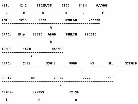
KSTL 1212 33025/35 0800 71SN 9//005 INTER 1215 0000 39BLSN 9//000 GRADU
1516 33020 4800 38BLSN 7SC030 TEMPO 1620 85SNSH GRADU 2122 33015 9999 WX
NIL 3SC030 RAPID 00 VRB05 9999 SKC The forecast is broken down into the
elements lettered "a" to "n" to aid in the discussion.
|
a. Station identifier. The TAF code uses ICAO 4-letter station identifiers.
b. Valid time. Valid Time of the forecast follows station identifier. "1212" means a 24-hour forecast valid from 1200 Z until 1200 Z the following day.
c. Wind. The wind forecast is usually a 5-digit group showing direction in 3 digits and speed in 2 digits. When the wind is expected to be 100 knots or more, the group is 6 digits with speed shown in 3 digits. When the speed is gusty or variable, peak speed is separated from average speed with a slash. For example, in the KSTL TAF, "33025/35" means wind 330, average speed 25 knots, peak speed 35 knots. A group "160115/130" means wind 160, 115 knots, peak speed 130 knots. "00000" means calm; "VRB" followed by speed indicates direction variable; that is, "VRB10" means wind direction variable at 10 knots.
d. Visibility. Visibility is forecast in meters. Table I converts meters to miles. "0800" is 800 meters or 1/2 mile.
e. Significant weather. Significant weather is decoded using Table 11. Groups in the table are numbered sequentially. Each number is followed by an acronym suggestive of the weather; you can soon learn to read most of the acronyms without reference to the table. Examples:
FIGURE 1-7. ICAO TERMINAL FORECAST (TAF) - Continued
"17TS," thunderstorm; "18SQ," squall' "31SA," sandstorm; "60RA," rain; "85SNSH," snow shower. "XX" between the number and acronym means "heavy." Examples: "33XXSA," heavy sandstorm; "67XXFZRA," heavy freezing rain. In the KSTL forecast, "71SN" means light snow. The TAF encodes only the single most significant type of weather unlike the U.S. domestic FT which permits encoding of multiple weather types.
f. Clouds. The cloud group is a 6-character group. The first digit is sky coverage in octas (eighths) as shown in Table III. The two letters identify cloud type as shown in the table. The last three digits are cloud height in hundreds of feet. In the KSTL TAF, "9//005" means sky obscured (9), clouds not observed (//), vertical visibility 500 feet (005). The TAF may include as many cloud groups as necessary to describe expected sky condition.
g. and i. Variation from prevailing conditions. Variation from prevailing conditions are identified by the contractions INTER and TEMPO as defined below. In the KSTL TAF, "INTER 1215 0000 39BLSN 9//000" means intermittently from 1200 Z to 1500 Z (1215) visibility zero meters (0000) or zero miles, blowing snow (39BLSN), sky obscured, clouds not observed, vertical visibility zero (9//000). "TEMPO 1620 85SNSH" means between 1600 Z and 2000 Z, temporary, or brief, snow showers. Omission of other groups imply no significant change in wind, visibility, or cloud cover.
h., j., and k. An expected change in prevailing conditions. An expected change in prevailing conditions is indicated by the contraction GRADU, RAPID, or FRONT as defined below. In the KSTL TAF, "GRADU 1516 33020 4800 38BLSN 7SC030" means a gradual change between 1500 Z and 1600 Z to wind 330 at 20 knots, visibility 4,800 meters or 3 miles (Table I), blowing snow, 7/8 stratocumulus (Table III) at 3,000 feet. "GRADU 2122 33015 9999 WX NIL 3SC030" means a gradual change between 2100 Z and 2200 Z to wind 330 at 15 knots, visibility 10 kilometers or more (more than 6 miles), no significant weather, 3/ 8 stratocumulus at 3,000 feet. "RADIP 00 VRB05 9999 SKC" means a rapid change about 0000 Z to wind direction variable at 5 knots, visibility than 6 miles, sky clear.
Listed below are a few contractions used in the TAF. Some of the contractions are followed by time entries indicated by "tt" or "tat" or by probability, "pp":
GRADU tttt - A gradual change occurring during a period in excess of one-half hour. "tttt" are the beginning and ending times of the expected change to the nearest hour; that is, "GRADU 1213" means the transition will occur between 1200 Z and 1300 Z.
RAPID tt - A rapid change occurring in one-half hour or less. "tt" is the time to the nearest hour of the change; that is, "RAPID 23" means the change will occur about 2300 Z.
TEMPO tttt - Temporary changes from prevailing conditions lasting less than one hour. "tat" are the earliest and latest change times during which the temporary changes are expected; that is, "TEMPO 0107" means the temporary changes may occur between 0100 Z and 0700 Z.
INTER tttt - Intermittent changes from prevailing conditions are expected to occur frequently and briefly. "tttt" are the earliest and latest times the brief changes are expected; that is, "INTER 1518" means that the brief changes may occur between 1500 Z and 1800 Z, the changes to persist for less than one half the time period.
FIGURE 1-7. ICAO TERMINAL FORECAST (TAF) - Continued
CAVOK - Ceiling and visibility OK. No clouds below 5,000 feet or below the highest minimum sector altitude, whichever is greater, and no cumulonimbus. Visibility 6 miles or greater. No precipitation, thunderstorms, shallow fog or drifting snow.
PROB pp - Probability of conditions occurring. "pp" is the probability in percent; that is, "PROB 20" means a 20% probability of the conditions occurring.
WX NIL - No significant weather or obstructions to vision.
SKC - Sky clear.
l. Icing. An icing group may be included. It is a 6-digit group. The first digit is 6, identifying it as an icing group. The second digit is the type of ice accretion from Table IV. The next three digits are height of the base of the icing layer in hundreds of feet. The last digit is the thickness of the layer in thousands of feet. For example, let's decode the group "680304". "6" indicates an icing forecast; "8" indicates severe icing in cloud (Table IV); "030" means the base of the icing is at 3,000 feet; and "4" specifies a layer 4,000 feet thick.
m. Turbulence. A turbulence group also may be included. It also is 6-digit group coded the same as the icing group except a "5" identifies the group as a turbulence forecast, and type of turbulence is from Table IV. To decode the group "590359"; "5" identifies a turbulence forecast; "9": specifies frequent severe turbulence in cloud (Table IV); "035" means the base of the turbulent layer is 3,500 feet; "9" specifies that the turbulence layer is 9,000 feet thick.
When either an icing or a turbulent layer is expected to be more than 9,000 feet thick, multiple groups are used; the top specified in one group is coincident with the base in the following group. Let's assume a cloud base at 5,000 feet and the forecaster expects frequent turbulence in thunderstorms from the surface to 45,000 feet; the most hazardous turbulence is at midlevels. This could be encoded 530005 550509 591409 592309 553209 554104. While you most likely will never see such a complex coding with this many groups, the flexible TAF code permits it.
n. Temperature. A temperature code is seldom included in a terminal
forecast. However, it may be included if critical to aviation. It may be
used to alert the pilot to high density altitude or possible frost when
on the ground. The temperature group is identified by the digit "0". The
next two digits are time to the nearest hour GMT at which the temperature
will occur. The last two digits are temperature in degrees Celsius. A minus
temperature is preceded by the letter "M." Examples: "02137" means temperature
at 2100 Z is expected to be 37 C, about 99 F; "012M02" means temperature
at 1200 Z is expected to be minus 2C. A forecast may include more than
one temperature group.