
|
Thunderstorms and their associated hazards. Feather Canyons?
by Phyllis-Anne Duncan |
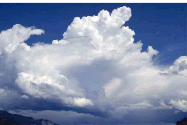 |
Joni Mitchell sang of looking at clouds as "ice cream castles in the air, feather canyons everywhere." The song, "Both Sides Now," goes on to remind us there is another side of clouds- "but now they only block the sun; they rain and snow on everyone..." A billowing mass of cumulonimbus clouds is a beautiful thing to watch-from the ground-and it is a summer pastime I enjoy. In fact, thunderstorms-harbingered by those "feather canyons"-are one of nature's most awesomely beautiful displays. As an aviator, though, I also "look at clouds from both sides," and I know that within their darkness and physical displays of power they contain about every aviation hazard known to humanity: wind, rain, icing, turbulence, wind shear, microbursts, tornadoes, hail, lightning-the list goes on.
Space-age radar allows us to "see" into thunderstorms more than ever before, and forecasters can predict their intensity, track, location, and duration better than ever. Like some macabre home movie on cable TV weather channels, we can watch storms pro-gress through their life cycle, but all the technology aside, it remains true that a storm's outward appearance-which is what is most often presented to our pilots' eyes-can in no way correlate the amount of rain, turbulence, etc., within the storm. Prediction, as always, is still an inexact science. Consequently, penetrating a thunderstorm is at best a craps shoot; at worst it symbolizes someone bent on self-destruction.
Where? When?
If you have the means to live in a tropical area of the world,
you also have the possibility of year-round thunderstorms. Spring,
summer, and fall are the seasons of thunderstorm discontent in
mid-latitudes. And if you want to avoid thunderstorms for most
of the year, try the Arctic.
Figure 1 (page 1) shows the average number of thunderstorms per year in the 48 conterminous states. As you can see, central Florida, in addition to its various amenities, has the dubious distinction of having the most thunderstorms per year.
Seasonally, spring time (March, April, May) means an increase in thunderstorm activity in nearly half of the country. Only the far western U.S. averages fewer than 10 days of thunderstorms in the summer . The number of days with thunderstorms then precipitously drops off with the coming of autumn , and winter means few thunderstorms or none (except for the Gulf Coast of Louisiana), as seen in Figure.
Again, another one of those truths is that a thunderstorm can arise anytime the required conditions exist-moist, unstable air that gets lifted.
On the Inside
FAA Advisory Circular (AC) 00-6A, Aviation Weather, says, "For a thunderstorm to form, the air must have (1) sufficient water vapor, (2) an unstable lapse rate, and (3) an initial upward boost (lifting)." The "upward boost" is the key; without it, no storm. Air can be lifted by surface heating (why thunderstorm frequency is so high in the summer months), sloping terrain (some pretty intense storms can occur near mountainous terrain), converging winds (all that energy has to go somewhere), frontal surfaces, or any combination of the above. When the moist, unstable air is forced upward in an initial updraft, the air becomes cooled, resulting in condensation. This is the beginning of the cumulus cloud. The condensation releases latent heat, which increases buoyancy in the cloud and fuels the upward movement which, in turn, draws more water vapor into the cloud. The updraft is now said to be "self-sustaining" as this cycle of cooling, condensation, uplifting continues. This is the billowing effect we can see as we watch cumulus clouds grow before our eyes.
A thunderstorm is said to have a "life cycle" of three, progressive stages:
Cumulus Stage
Mature Stage
Dissipating Stage
The Cumulus Stage
Not all cumulus clouds become thunderstorms, but every thunderstorm begins as a cumulus cloud. The cumulus stage is characterized by the uplifting of the moist, unstable air (Figure 6A, next page). This updraft extends from near the surface to the top of the cloud and varies in strength. Clouds may grow at the phenomenal rate of 3,000 feet per minute, which means they can easily outclimb your aircraft. The time-honored rule of thumb is never to climb to avoid a thunderstorm because you can be overtaken by the updraft.
The size of water droplets is very small in the early part of the cumulus stage, but the size of the droplets grows with the size of the cloud, and they quickly become raindrop size. When the rising air carries the water droplets above the freezing level, the potential for icing conditions is created. Eventually, the cold raindrops grow so heavy they cannot be sustained aloft by the uplifting air, and they fall, dragging air down with them. When the downdraft coexists with the updrafts, the thunderstorm is said to be mature.
The Mature Stage
When the rain begins to fall, it signals the creation of a downdraft and the maturity of the storm. The cold rain now lessens the latent heat created by condensation, making the downdraft cooler than the air surrounding it (Figure 6B, next page). Pilots on the ground shiver and jokingly comment on the "air from 50,000 feet" when they feel that first rush of cool air before the rain arrives. Because the air in the downdraft is cooler than the air surrounding it, it accelerates downward-up to 2,500 feet per minute-then spreads outward at the surface. This is characterized by strong and gusty surface winds, a temperature drop that is sometimes sharp, and a quick rise in pressure (cold air is more dense). This surface wind surge is sometimes referred to as a "plow wind" or gust front because it pushes air (and other things) in front of it aside.
Even with all this down-rushing air, updrafts in the mature stage have reached their maximum-possibly now 6,000 feet per minute. When you have updrafts and downdrafts so close to each other, they create strong, vertical shears and extreme turbulence. The mature stage is the time of the thunderstorm's greatest intensity. Yet, the downdrafts are also the beginning of the end.
The Dissipating Stage
Figure 6C (next page) shows the dissipating stage of a thunderstorm. The rain ends, downdrafts cease, and the thunderstorm is over. The cloud forms its characteristic anvil, pointing to where the air mass is headed. The clouds remaining are harmless now, unless they take in more moisture, become unstable again, and encounter another lifting force. The life cycle starts again.
How Big is Big?
Most of what we've talked about here is a single, thunderstorm cell. Yet, a single cell diameter can range from five miles to as much as 30 miles! In moist climates cloud bases are near the surface, but can range up to 10,000-foot bases over dry areas. Thunderstorm tops average between 25,000 and 45,000 feet but have been known to grow beyond 65,000 feet.
How Long?
The duration of a thunderstorm is linked to its severity-the more severe, the longer they endure. Air mass thunderstorms occur randomly and most often from surface heating. They usually last only for an hour or two with moderate wind gusts and rainfall, but they are still "rough," too rough to fly through. When air mass storms reach their mature stage, rain falls next to the updraft and friction slows the updraft and can actually reverse it to a downdraft. The storm is said to be "self-destructive" since the cold, down-rushing air cools the surface and cuts off the heating element, as it were. Twenty minutes to an hour and a half are usually the duration of an air mass storm.
Middle and late afternoons in the summer are when the surface is the warmest, and these are the peak times for air mass storms. These are ones that spring up on a summer afternoon and cancel your plans for a quick flight. But they're just as quickly gone, and flying conditions can prevail again.
Air mass storms also occur off-shore, but the best time for this is late hours of darkness when cool air flows from the land over warm water, picks up moisture, and is lifted. Steady-state thunderstorms are associated with weather systems-fronts, converging winds, and troughs which force air upward along long distances. The squall line of thunderstorms is truly to be feared since they can last for hours. A squall line is a narrow band of active thunderstorms, often ahead of a cold front. AC 00-24B, Thunderstorms, says that a squall line "presents the single most intense weather hazard to aircraft." Squall lines may be too long and too wide to detour around. Needless to say, it is not safe to fly under a squall line or even an isolated cell.
Steady state storms in a squall line last longer because rain falls outside the updraft, so there is no friction drag to slow the updraft down. It continues, and rain and hail are sometimes "thrown out" of the cell miles away from the main cell itself. (Figure 7)
What's So Dangerous?
Just about everything in a thunderstorm is dangerous. Let's
talk about the "worst" first.
Tornadoes
In May Hollywood regaled us with the movie, Twister, which
showed some spectacular, special effect renderings of tornadoes.
Tornadoes are a case where reality is probably worse than anything
special effects wizards can come up with. Yet, tornadoes are,
like their progenitors, intensely and deadly beautiful. Tornado
chasers drive rapidly from area to area in the summer, trying
to "catch" these monstrous dervishes on video, radar,
infrared, so that they can later "dissect" them and,
hopefully, come up with better ways to detect them.
Other meteorologists sit safely inside their labs and watch on a Doppler radar display the characteristic hook form, denoting a possible tornado. Just a few years ago, this technology didn't exist, and forecasters had to wait for someone to sight a tornado's touchdown before issuing a warning. The drawbacks of this are obvious, and as forecasting technologies have improved, the loss of life, at least, from tornadoes has diminished dramatically. (They do still seem to find those trailer parks, though.)
Violent thunderstorms draw air strongly and rapidly in at their bases. If the air coming in to the cell has any rotation to it, it can form a vortex that extends from the surface well up into the cloud. Wind in such a "concentrated vortex" can exceed 200 knots, and the pressure inside the vortex is quite low. (Remember: "As the velocity of a fluid increases, its pressure decreases.") The winds pick up dust and debris, which make the funnel cloud that extends downward from the base of the cumulonimbus cloud visible. Until it touches the surface, it is still "merely" a funnel cloud; once it contacts the earth, it's a tornado or a "waterspout" over water.
Isolated thunderstorms will occasionally spawn a tornado, but they are more likely to be associated with steady state storms along cold fronts or in squall lines. Extreme turbulence can be present miles away from "tornado-ripe" storms.
AC 00-6A understates it: "An aircraft entering a tornado is almost certain to suffer structural damage." An event that can pick up cars, buses, tractors, not to mention houses can easily render an aircraft into its component parts. And remember, the funnel cloud extends up into the cumulonimbus cloud and "hides" there, especially if you have your head in the cockpit on instruments.
Cumulonimbus mammatus clouds -those with pendulant, rounded bases-appear in connection with tornadoes, and mammatus clouds mentioned in a weather report or forecast indicate an extreme hazard. At some point in our history, every state in the U.S. has experienced a tornado. (Why, in the little town of Culpeper, VA where I grew up, they still talk about The Tornado-the one that happened over 40 years ago and which wrecked a bunch of barns.) However, the Great Plains east of the Rockies are "home" to most of the serious tornadoes in the country. In the vast expanses of Tornado Alley, communities have warning sirens for approaching tornadoes that send people rushing to their storm cellars.
Turbulence
Turbulence within even an isolated thunderstorm can be severe enough to exceed the structural integrity of an aircraft. Another aviation rule of thumb is that hazardous turbulence can be found in all thunderstorms. The strongest turbulence occurs with the shear between updrafts and downdrafts, but turbulence has been encountered thousands of feet above a storm and up to 20 miles laterally from a storm.
The plow wind or gust front before a storm means turbulence close to the surface, and this is sometimes marked by a "roll cloud" on the leading edge of storms associated with squall lines or fronts. Figure 8 (next page) diagrams where turbulence can be expected. This turbulence means that if you inadvertently penetrate a thunderstorm, holding altitude may not only be impossible but also your attempts to hold a constant altitude could overstress the aircraft. As we noted earlier, updrafts can travel up to 6,000 feet per minute. You cannot hope to counter that kind of force and keep the aircraft intact. The best thing to do is keep your attitude constant and ride out the storm.
Airborne weather radar has generally not yet progressed to the point where it can "see" turbulence, but it can see the severity of the thunderstorm that will inevitably mean turbulence. Expect one with the other. (New airborne Doppler weather radars advertise a "turbulence/windshear mode.")
Icing
When updrafts carry the moist air above the freezing level, the water becomes supercooled. Supercooled water can freeze on impact with an aircraft, adding to its thunderstorm woes. Icing in a thunderstorm can be rime, clear, or mixed, and icing encounters can be frequent in a series of cells. You don't need the increased weight, decreased lift, increased stall speed, etc., from icing adding to the danger of a thunderstorm encounter.
Hail
Some consider hail to be second in hazard to turbulence in a thunderstorm. If the supercooled drops in a thunderstorm are propelled above the freezing level and freeze, they "crash" into each other, creating a growing iceball we call a hailstone. Every year on the national news we see home video of golfball-sized hail, baseball-sized hail, even the occasional softball-sized hail. Severe thunderstorms that have built to great height produce the biggest hailstones. Eventually, they become so large, the updrafts can't support them, and they fall-maybe some distance from the storm's center. Aircraft have encountered hail in clear air miles from the nearest thunderstorm.
Most of the time as the hailstones fall through warmer air, they melt and fall as rain. So, you can imagine how large they must start out at altitude if they hit the ground the size of a softball. Yet, even if there is only rain, it doesn't mean the absence of hail. Hail can be associated with any thunderstorm and especially beneath the anvil cloud of a large storm. In addition to the disconcerting noise of hail hitting an aluminum-skin aircraft, hail as small as 1/4-inch in diameter can cause aircraft damage.
Low Ceilings and Visibility
Within the thunderstorm itself, visibility is nearly zero. Precipitation and dust at the surface beneath a storm can restrict visibility and lower ceilings. The problems are the same as any phenomenon that diminishes ceilings and visibility.
| ?AvStop Online Magazine Contact Us Return Home |