 |
|
| INSTRUMENT PROCEDURES HANDBOOK |
|
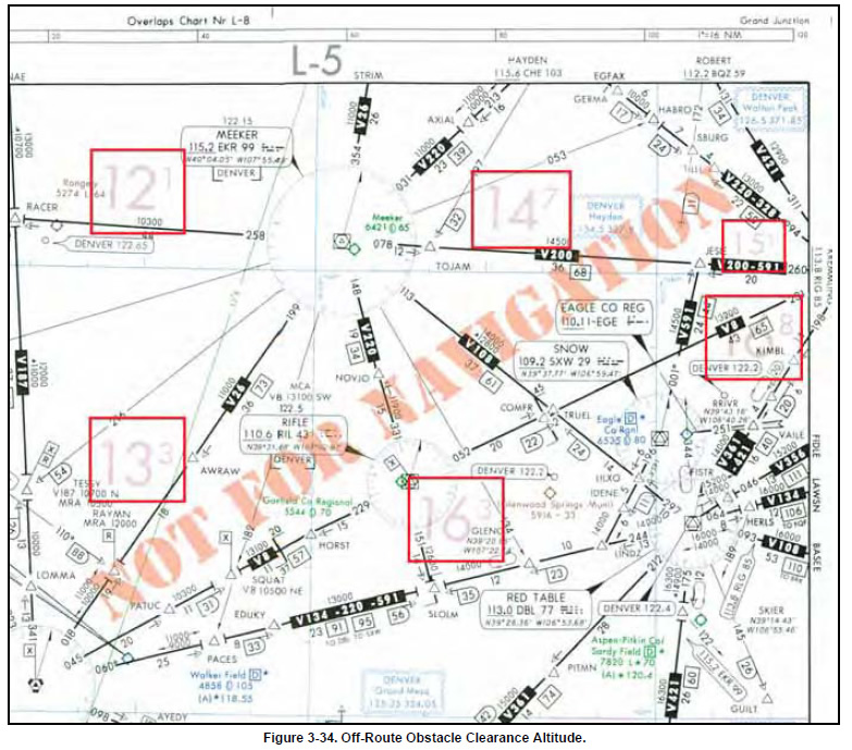
OFF ROUTE OBSTRUCTION CLEARANCE ALTITUDE An off-route obstruction clearance altitude
(OROCA) is an off-route altitude that provides
obstruction clearance with a 1,000-foot buffer in nonmountainous
terrain areas and a 2,000-foot buffer in
designated mountainous areas within the U.S. This
altitude may not provide signal coverage from
ground-based navigational aids, air traffic control
radar, or communications coverage. OROCAs are
intended primarily as a pilot tool for emergencies and
situational awareness. OROCAs depicted on NACO
en route charts do not provide you with an acceptable
altitude for terrain and obstruction clearance for the
purposes of off-route, random RNAV direct flights in
either controlled or uncontrolled airspace. OROCAs
are not subject to the same scrutiny as MEAs, MVAs,
MOCAs, and other minimum IFR altitudes. Since
they do not undergo the same obstruction evaluation, airport airspace analysis procedures, or flight inspection,
they cannot provide the same level of confidence
as the other minimum IFR altitudes.
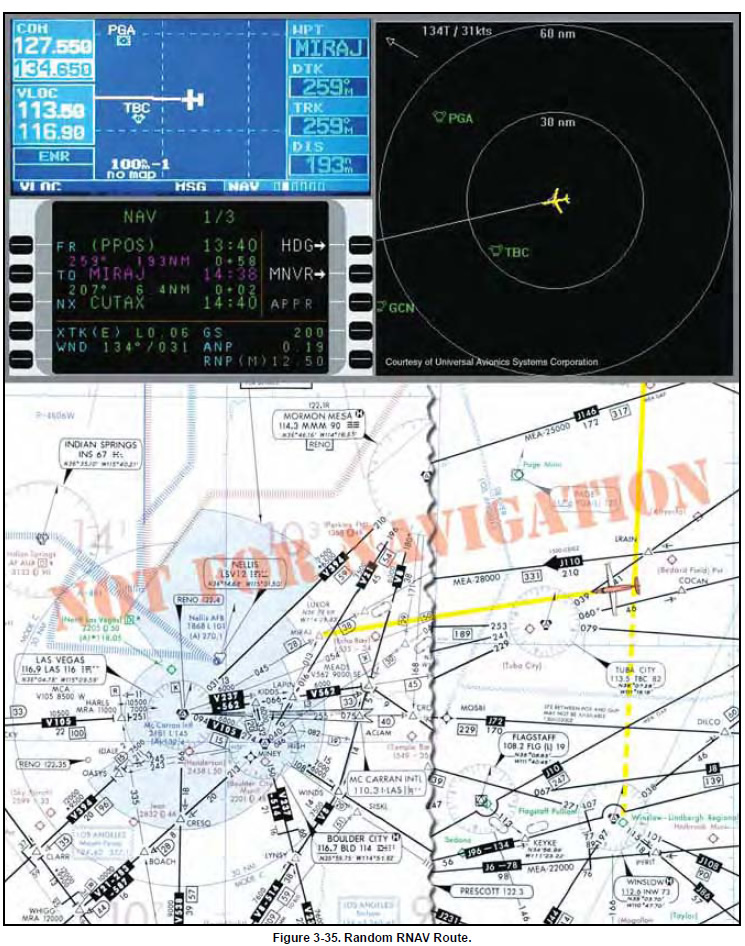
In Figure 3-35 on page 3-30, you are northeast of Tuba City VORTAC at FL 200 using RNAV (showing both GPS and FMS), RNAV direct on a southwesterly heading to Lindbergh Regional Airport in Winslow. As you monitor your position and cross check your avionics against the high altitude en route chart, you receive a company message instructing you to divert to Las Vegas, requiring a change in your flight plan as highlighted on the depicted chart excerpt.
During your cockpit review of the high and low altitude en route charts, you determine that your best course of action is to fly direct to the MIRAJ waypoint, 28 DME northeast of the Las Vegas VORTAC on the 045° radial. This places you 193 NM out on a 259° magnetic course inbound, and may help you avoid diverting north, allowing you to bypass the more distant originating and intermediate fixes feeding into Las Vegas. You request an RNAV random route clearance direct MIRAJ to expedite your flight. Denver Center comes back with the following amended flight plan and initial clearance into Las Vegas: “Marathon five sixty four, turn right heading two six zero, descend and maintain one six thousand, cleared present position direct MIRAJ.” The latitude and longitude coordinates of your present position on the high altitude chart are N36 19.10, and W110 40.24 as you change your course. Notice your GPS moving map (upper left) and the FMS control display unit (below the GPS), and FMS map mode navigation displays (to the right of the GPS) as you reroute your flight to Las Vegas. For situational awareness, you note that your altitude is well above any of the OROCAs on your direct route as you arrive in the Las Vegas area using the low altitude chart. |