|
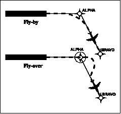
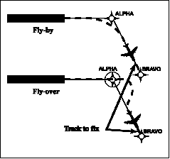
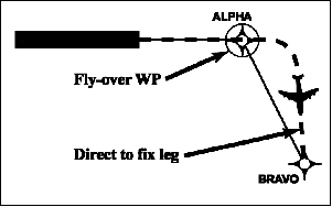
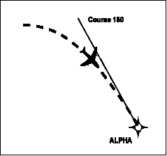
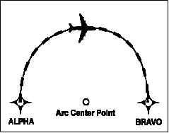
1-2-1. Area Navigation (RNAV) a. General. RNAV is a method of navigation that permits aircraft operation on any desired flight path within the coverage of station-referenced navigation aids or within the limits of the capability of self-contained aids, or a combination of these. In the future, there will be an increased dependence on the use of RNAV in lieu of routes defined by ground-based navigation aids. RNAV routes and terminal procedures, including departure procedures (DPs) and standard terminal arrivals (STARs), are designed with RNAV systems in mind. There are several potential advantages of RNAV routes and procedures: 1. Time and fuel savings, 2. Reduced dependence on radar vectoring, altitude, and speed assignments allowing a reduction in required ATC radio transmissions, and 3. More efficient use of airspace. In addition to information found in this manual, guidance for domestic RNAV DPs, STARs, and routes may also be found in Advisory Circular 90-100, U.S. Terminal and En Route Area Navigation (RNAV) Operations. b. RNAV Operations. RNAV procedures, such as DPs and STARs, demand strict pilot awareness and maintenance of the procedure centerline. Pilots should possess a working knowledge of their aircraft navigation system to ensure RNAV procedures are flown in an appropriate manner. In addition, pilots should have an understanding of the various waypoint and leg types used in RNAV procedures; these are discussed in more detail below. 1. Waypoints. A waypoint is a predetermined geographical position that is defined in terms of latitude/longitude coordinates. Waypoints may be a simple named point in space or associated with existing navaids, intersections, or fixes. A waypoint is most often used to indicate a change in direction, speed, or altitude along the desired path. RNAV procedures make use of both fly-over and fly-by waypoints. (a) Fly-by waypoints. Fly-by waypoints are used when an aircraft should begin a turn to the next course prior to reaching the waypoint separating the two route segments. This is known as turn anticipation. (b) Fly-over waypoints. Fly-over waypoints are used when the aircraft must fly over the point prior to starting a turn. NOTE- FIG 1-2-1
|
|
RNP Level |
Typical Application |
Primary Route Width (NM) - |
|
0.1 to 1.0 |
RNP SAAAR Approach Segments |
0.1 to 1.0 |
|
0.3 to 1.0 |
RNP Approach Segments |
0.3 to 1.0 |
|
1 |
Terminal and En Route |
1.0 |
|
2 |
En Route |
2.0 |
NOTE-
1. The "performance" of navigation in RNP refers not only to the level of accuracy of a particular sensor or aircraft
navigation system, but also to the degree of precision with which the aircraft will be flown.
2. Specific required flight procedures may vary for different RNP levels.
TBL 1-2-2
RNP Levels Supported for International Operations
|
RNP Level |
Typical Application |
|
4 |
Projected for oceanic/remote areas where 30 NM horizontal separation is applied |
|
10 |
Oceanic/remote areas where 50 NM lateral separation is applied |
c. Other RNP Applications Outside the U.S. The FAA and ICAO member states have led initiatives in implementing the RNP concept to oceanic operations. For example, RNP-10 routes have been established in the northern Pacific (NOPAC) which has increased capacity and efficiency by reducing the distance between tracks to 50 NM. (See TBL 1-2-2.)
d. Aircraft and Airborne Equipment Eligibility for RNP Operations. Aircraft meeting RNP criteria will have an appropriate entry including special conditions and limitations in its Aircraft Flight Manual (AFM), or supplement. Operators of aircraft not having specific AFM-RNP certification may be issued operational approval including special conditions and limitations for specific RNP levels.
NOTE-
Some airborne systems use Estimated Position Uncertainty (EPU) as a measure of the current estimated
navigational performance. EPU may also be referred to as
Actual Navigation Performance (ANP) or Estimated
Position Error (EPE).
1-2-3. Use of Suitable Area Navigation (RNAV) Systems on Conventional Procedures and Routes
a. Discussion. This paragraph sets forth policy concerning the operational use of RNAV systems for the following applications within the U.S. National Airspace System (NAS):
1. When a very-high frequency omni-directional range (VOR), DME, tactical air navigation (TACAN), VORTAC, VOR/DME, nondirectional beacon (NDB), or compass locator facility including locator outer marker and locator middle marker is out-of-service (that is, the navigation aid (navaid) information is not available); an aircraft is not equipped with an ADF or DME; or the installed ADF or DME on an aircraft is not operational. For example, if equipped with a suitable RNAV system, a pilot may hold over an out-of-service NDB. This category of use is referred to as “substitute means of navigation.”
2. When a VOR, DME, VORTAC, VOR/DME, TACAN, NDB, or compass locator facility including locator outer marker and locator middle marker is operational and the respective aircraft is equipped with operational navigation equipment that is compatible with conventional navaids. For example, if equipped with a suitable RNAV system, a pilot may fly a procedure or route based on operational VOR using RNAV equipment but not monitor the VOR. This category of use is referred to as “alternate means of navigation.”
NOTE-
1. Additional information and associated requirements
are available via a 90-series Advisory Circular titled “Use
of Suitable RNAV Systems on Conventional Routes and
Procedures.”
2. Good planning and knowledge of your RNAV system are critical for safe and successful operations.
3. Pilots planning to use their RNAV system as a substitute
means of navigation guidance in lieu of an out-of-service
navaid may need to advise ATC of this intent and
capability.
b. Types of RNAV Systems that Qualify as a
Suitable RNAV System. When installed in accordance with appropriate airworthiness installation
requirements and operated in accordance with
applicable operational guidance (e.g., aircraft flight
manual and Advisory Circular material), the
following systems qualify as a suitable RNAV
system:
1. An RNAV system with TSO-C129/ -C145/-C146 (including all revisions (AR)) equipment, installed in accordance with AC 20-138 (including AR) or AC 20-130A, and authorized for instrument flight rules (IFR) en route and terminal operations (including those systems previously qualified for “GPS in lieu of ADF or DME” operations), or
2. An RNAV system with DME/DME/IRU inputs that is compliant with the equipment provisions of AC 90-100A, U.S. Terminal and En Route Area Navigation (RNAV) Operations, for RNAV routes.
NOTE-
RNAV systems using DME/DME/IRU, without GPS/WAAS
position input, may only be used as a substitute means of
navigation when specifically authorized by a Notice to
Airmen (NOTAM) or other FAA guidance for a specific
procedure, NAVAID, or fix. The NOTAM or other FAA
guidance authorizing the use of DME/DME/IRU systems
will also identify any required DME facilities based on an
FAA assessment of the DME navigation infrastructure.
c. Allowable Operations. Operators may use a suitable RNAV system in the following ways.
1. Determine aircraft position over or distance from a VOR (see NOTE 4 below), TACAN, NDB, compass locator, DME fix; or a named fix defined by a VOR radial, TACAN course, NDB bearing, or compass locator bearing intersecting a VOR or localizer course.
2. Navigate to or from a VOR, TACAN, NDB, or compass locator.
3. Hold over a VOR, TACAN, NDB, compass locator, or DME fix.
4. Fly an arc based upon DME.
These operations are allowable even when a facility is explicitly identified as required on a procedure (e.g., “Note ADF required”).
These operations do not include navigation on localizer-based courses (including localizer back-course guidance).
NOTE-
1. These allowances apply only to operations conducted
within the NAS.
2. The allowances defined in paragraph c apply even when a facility is explicitly identified as required on a procedure (e.g., “Note ADF required”). These allowances do not apply to procedures that are identified as not authorized (NA) without exception by a NOTAM, as other conditions may still exist and result in a procedure not being available. For example, these allowances do not apply to a procedure associated with an expired or unsatisfactory flight inspection, or is based upon a recently decommissioned navaid.
3. ADF equipment need not be installed and operational, although operators of aircraft without an ADF will be bound by the operational requirements defined in paragraph c and not have access to some procedures.
4. For the purpose of paragraph c, “VOR” includes VOR, VOR/DME, and VORTAC facilities and “compass locator” includes locator outer marker and locator middle marker.