AVIATION WEATHER OBSERVATIONS AND REPORTS
Note: For information on an important future change in the aviation weather reporting and forecasting system, see the Aviation Routine Weather Report (METAR), in this section, and International Terminal Aerodrome Forecast (TAF), in Section 4.
When a Surface Aviation Observation (SAO) is reported and transmitted, it is a weather report. A SAO Report contains some or all of the following elements:
1. Station designator
2. Type and time of report
3. Type of automated observing system (if applicable)
4. Sky condition and ceiling
5. Visibility
6. Weather and obstructions to vision
7. Sea level pressure
8. Temperature and dew point
9. Wind direction, speed and character
10. Altimeter setting
11. Remarks and coded data
Those elements not occurring at observation time or not pertinent to the Observation are omitted from the report. When an element should be included but is unavailable, the letter "M" is transmitted in lieu of the missing element. If an element is estimated by the observer, the letter "E" will precede that element. Those elements that are included are transmitted in the above sequence.
The following five (5) Manual Surface Aviation Observation reports are used in discussing the above 11 elements.
INK SA 1854 CLR 10 106/77/63/1112G18/000
BOI SA 1854 150 SCT 10 181/62/42/1304/015
MDW RS 1856 -X M7 OVC 11/2R+F 990/63/61/3205/980/RF2 RB12
JFK RS 1853 W5 X 1/4F 180/68/64/1804/006/
R04RVR22V30 TWR VSBY 1/2
LAX SP 1831 7 SCT 250 SCT 3HK 2504/991
STATION DESIGNATOR
The station designator is the three-letter identifier for the reporting station. These five reports are from Wink, TX (INK); Boise, ID (BOI); Midway Airport, Chicago, IL (MDW); John F. Kennedy Airport, New York City, NY (JFK); and Los Angeles, CA (LAX).
TYPE AND TIME OF REPORT
The two basic types of reports are:
1. Record Observation (SA), reports taken on the hour;
2. Special reports (RS or SP), observations taken as needed to report
significant changes in weather.
Record Observations (SA) are transmitted in collectives and are identified by a heading. The first two reports are of this type (INK and BOI). A Record Special is a Record Observation that reports a significant change in weather. It is identified by the letters "RS" as shown in the reports from MDW and JFK. A Special "SP" is an observation taken between Record Observations to report a significant change in weather. The report from LAX is a Special Observation. Specials (SP's) do not include temperature, dew point, or wind. All reports transmitted must convey the time in Coordinated Universal Time (UTC) along with the type of Observation.
SKY CONDITION AND CEILING
A clear sky or a layer of clouds or obscuring phenomena aloft is reported by one of the first seven sky cover designators in Table 2-1. A layer is defined as clouds or obscuring phenomena aloft when the base is at approximately the same level. The height of the base of a layer precedes the sky cover designator. Height is in hundreds of feet above ground level (AGL).
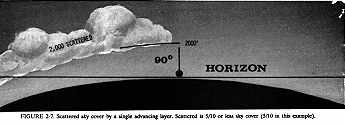
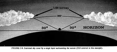
Note that INK is reporting the sky clear. No height precedes the designator since no sky cover is reported. BOI reports a scattered layer at 15,000 feet above the station. Figures 2-7 and 2-8 illustrate single layers of scattered clouds.
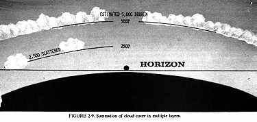
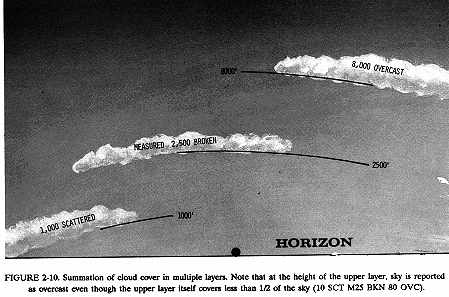
When more than one layer is reported, layers are in ascending order of height. For each layer above a lower layer or layers, the sky cover designator for that layer will be the total sky cover which includes that layer and all lower layers. In other words, the summation concept of cloud layers is used. LAX reports two layers, a scattered layer at 700 feet and a higher layer at 25,000 feet. Total coverage of the two layers does not exceed 5/10 coverage, so the upper layer also is reported as scattered. Figures 2-9 and 2-10 illustrate the summation of multiple layers.
"Transparent" sky cover is clouds or obscuring phenomena aloft through which blue sky or higher sky cover is visible. As explained in Table 2-1, a scattered, broken, or overcast layer may be reported as "thin." To be classified as thin, a layer must be half or more transparent. Remember that sky cover of a layer includes all sky cover reported below that layer. For example, if at LAX the sky had been visible through half or more of the total sky cover reported by the higher layer, the report would have been
LAX SA 1854 7 SCT 250 -SCT etc.
Any phenomenon based at the surface and hiding all or part of the sky is reported as SKY OBSCURED or SKY PARTIALLY OBSCURED (Table 2-1). An obscuration or partial obscuration may be caused by precipitation, fog, dust, blowing snow, etc. No height value precedes the designator for partial obscurations since vertical visibility is not restricted overhead. A height value precedes the designator for a total obscuration and denotes the vertical visibility into the phenomenon.
A ceiling is the height above the ground of the lowest layer of clouds or obscuring phenomena aloft that is reported as broken or overcast. This broken or overcast layer cannot be classified as "thin" nor can a surface-based obscuration be classified as "partial".
MDW reports a partial obscuration and an overcast layer at 700 feet. The overcast layer constitutes a ceiling at 700 feet. Note that the height of this ceiling layer is preceded by the letter "M." JFK reports a total obscuration of 500 feet. This height value is the vertical visibility into the obscuring phenomenon. Height of the ceiling value is preceded by the letter "W." The "M" and "W" are "ceiling designators."
A ceiling designator always precedes the height of the ceiling layer. Table 2-2 lists and explains ceiling designators. At MDW, the ceiling height was measured. JFK had an indefinite ceiling which was the vertical visibility into a surface-based total obscuration.
The sky cover and ceiling, as determined from the ground, represents as nearly as possible, what the pilot should experience in flight. In other words, a pilot flying at or above a reported ceiling layer should see less than half the surface below. A pilot descending through a surface-based total obscuration should first see the ground directly below from the height reported as vertical visibility into the obscuration. However, due to the differing viewing points of the pilot and the observer, the observed values and what the pilot sees do not always exactly agree. Figure 2-11 illustrates the effect of an obscured sky on the vision from a descending aircraft.
The letter "V" appended to the ceiling height indicates a variable ceiling. The range of variability is shown in remarks. Variable ceiling is reported only when the ceiling height is below 3,000 feet. As an example,
M12V OVC and in remarks CIG 10V14
MEASURED CEILING ONE THOUSAND TWO HUNDRED VARIABLE OVERCAST, CEILING VARIABLE BETWEEN ONE THOUSAND AND ONE THOUSAND FOUR HUNDRED.
The first three elements of the five reports would be interpreted as:
INK SA 1854 CLR...
WINK, 1854 ZULU, CLEAR
BOI SA 1854 150 SCT...
BOISE, 1854 ZULU, ONE FIVE THOUSAND SCATTERED
MDW RS 1856 -X M7 OVC...
CHICAGO MIDWAY, RECORD SPECIAL, 1856 ZULU, SKY PARTIALLY OBSCURED,
MEASURED CEILING SEVEN HUNDRED OVERCAST
JFK RS 1853 W5 X...
NEW YORK KENNEDY, RECORD SPECIAL, 1853 ZULU, INDEFINITE CEILING FIVE
HUNDRED SKY OBSCURED
LAX SP 1831 7 SCT 250 SCT...
LOS ANGELES, SPECIAL 1831 ZULU, SEVEN HUNDRED SCATTERED, TWO FIVE THOUSAND
SCATTERED
VISIBILITY
Prevailing visibility immediately follows sky and ceiling in the report. Prevailing visibility is considered representative of the visibility conditions at the observing site. This representative visibility is the greatest visibility equaled or exceeded throughout at least half the horizon circle, which need not be continuous. It is reported in statute miles and fractions.
Prevailing visibilities in the five reports are:
INK...10...
WINK...VISIBILITY ONE ZERO...
BOI...10...
BOISE...VISIBILITY ONE ZERO...
MDW...11/4...
CHICAGO MIDWAY...VISIBILITY ONE AND ONE-QUARTER...
JFK...1/4...
NEW YORK KENNEDY...VISIBILITY ONE-QUARTER...
LAX...3...
LOS ANGELES...VISIBILITY THREE...
When the prevailing visibility is less than 4 miles at either or both the tower and the weather observation station, the lowest of the two observations shall be the prevailing visibility in the body of the report. The other shall be reported in remarks.
TWR VSBY 1/2
TOWER VISIBILITY ONE-HALF MILE
The letter "V" suffixed to prevailing visibility denotes a variable visibility. The range of variability is shown in remarks. Variable visibility is reported only when it is critical to aircraft operations. As an example,
3/4V and in remarks VSBY 1/2V1
VISIBILITY THREE QUARTERS VARIABLE...
VISIBILITY VARIABLE BETWEEN ONE-HALF AND ONE.
Visibility in some directions may differ significantly from prevailing visibility. These significant differences are reported in remarks. For example, prevailing visibility is reported as 1 1/2 miles with a remark,
VSBY NE 2 1/2 SW 3/4
VISIBILITY NORTHEAST TWO AND ONE-HALF, SOUTHWEST THREE-QUARTERS
WEATHER AND OBSTRUCTIONS TO VISION
Weather and obstruction to vision when occurring at the station at observation time are reported immediately following visibility. If observed at a distance from the station, they are reported in remarks.
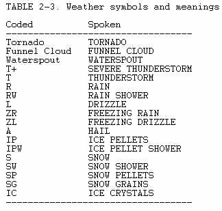
The term weather refers only to those items in Table 2-3 rather than to the more general meaning of all atmospheric phenomena. Weather includes all forms of precipitation plus tornadoes, funnel clouds, waterspouts and thunderstorms.
Precipitation is reported as one of three intensities. The intensity symbol follows the weather symbol:
Light -
Moderate (no sign)
Heavy +
No intensity is reported for hail (A) or ice crystals (IC). A thunderstorm is reported as "T" and a severe thunderstorm as "T+." A severe thunderstorm is one in which the surface wind is 50 knots or greater and/or surface hail is 3/4 inch or more in diameter.
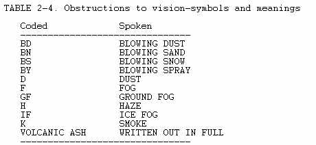
Obstructions to vision include the phenomena listed in Table 2-4. No intensities are reported for obstructions to vision. Note: Obstructions to vision are only reported for visibilities of 6 miles or less. Weather symbols are used regardless of visibility. Referring back to the initial five reports, INK and BOI report no weather or obstruction to vision, therefore, no entries appear in the reports. MDW reports heavy rain (R+) as the weather and fog (F) as the obstruction to vision. JFK reports fog (F) as an obstruction to vision.
LAX reports two obstructions to vision, haze (H) and smoke (K).
When obscuring phenomenon is surface based and partially obscures the sky, a remark reports tenths of sky hidden. For example,
K6
means 6/10 of the sky is hidden by smoke. Looking at the report from MDW, notice the remark "RF2". This means that 2/10 of the sky is hidden by rain and fog. A layer of obscuring phenomenon aloft is reported in the sky and ceiling portion the same as a layer of cloud cover is. A remark identifies the layer as an obscuring phenomenon. For example,
20 -BKN and a remark K20 -BKN
means that a thin broken layer of smoke is based at 2,000 feet above the surface.
SEA LEVEL PRESSURE
The U.S. is in the process of converting to metric units in it's weather reports. In the metric system, "hectoPascal" is the unit of pressure measurement and replaces "millibars" in current use. The units are equivalent; i.e., one millibar equals one hectoPascal, thus 1013.2 millibars is 1013.2 hectoPascals. In this publication, both millibars and hectoPascals will be used.
Sea level pressure is separated from the preceding elements by a space and is transmitted in Record hourly reports only. It is in three digits to the nearest tenth of a millibar/hectopascal. The decimal point is omitted. Sea level pressure usually is greater than 960.0 millibars/hectoPascals and less than 1050.0 millibars/hectoPascals. The first 9 or 10 is omitted. To decode, prefix a 9 or 10, whichever brings it closer to 1000.0 millibars/hectoPascals. The sea level pressures on the five reports are:
INK 1010.6 millibars/hectoPascals
BOI 1018.1 millibars/hectoPascals
MDW 999.0 millibars/hectoPascals
JFK 1018.0 millibars/hectoPascals
LAX not reported
TEMPERATURE AND DEW POINT
Temperature and dew point are in whole degrees Fahrenheit. They are separated from sea level pressure by a slash (/). If sea level pressure is not transmitted, temperature is separated from preceding elements by a space. Temperature and dew point are separated by a slash. A minus sign precedes a temperature or dew point when below zero (0) degrees F. From our five example reports, we have:
INK...76/62...
WINK...TEMPERATURE SEVEN SIX, DEW POINT SIX TWO...
BOI...62/42...
BOISE...TEMPERATURE SIX TWO, DEW POINT FOUR TWO...
MDW...66/61...
CHICAGO MIDWAY...TEMPERATURE SIX SIX, DEW POINT SIX ONE...
JFK...68/64...
NEW YORK KENNEDY...TEMPERATURE SIX EIGHT, DEW POINT SIX FOUR...
LAX...not reported
Example with minus values:
CAR...-4/-16
CARIBOU ME...TEMPERATURE MINUS FOUR, DEW POINT MINUS ONE SIX...
WIND
Wind follows dew point and is separated from it by a slash. The average two minute direction and speed are indicated in a four or five digit group. The first two digits are direction from which the wind is blowing. It is in tens of degrees referenced to true north, i.e., 01 is 10 degrees; 21 is 210 degrees. The last two or three digits are speed in knots; two digits for speeds less than 100 knots, three digits for speeds of 100 knots or greater. A calm wind is reported as 0000.
A gust is a variation in wind speed of at least 10 knots between peaks and lulls. A squall is a sudden increase of at least 15 knots in average wind speed to a sustained speed of 20 knots or more for at least one (1) minute. Gusts or squalls are reported by the letter "G" or "Q", respectively, following the average one-minute speed and followed by the peak speed in knots. For example,
1522Q37
... WIND ONE FIVE ZERO AT TWO TWO, GUST'S IN SQUALLS THREE SEVEN...
Winds decoded from our five reports are:
INK...1112G18...
WINK...WIND ONE ONE ZERO AT ONE TWO GUST'S ONE EIGHT...
BOI...1304...
BOISE...WIND ONE THREE ZERO AT FOUR...
MDW...3205
CHICAGO MIDWAY...WIND THREE TWO ZERO AT FIVE...
JFK...1804
NEW YORK KENNEDY...WIND ONE EIGHT ZERO AT FOUR...
LAX...2504
LOS ANGELES...WIND TWO FIVE ZERO AT FOUR...
When any part of the wind report is estimated (direction, speed, peak speed in gusts or squalls), the letter "E" precedes the wind group. Example,
E1522G28
...ESTIMATED WIND ONE FIVE ZERO AT TWO TWO GUSTS TWO EIGHT...
A few stations do not transmit sea level pressure, temperature and dew point. When the elements are not transmitted, the wind group is separated from the preceding element by a space as in this Special Observation from Clinton-Sherman, OK:
CSM SP W5 X 2F 1705/990
ALTIMETER SETTING
Altimeter setting follows the wind group and is separated from it by a slash. Normal range of altimeter settings are from 28.00 to 31.00 inches of mercury. The last three digits are transmitted with the decimal point omitted. The altimeter setting is decoded by prefixing the coded value with either a 2 or a 3 whichever brings the value closer to 30.00 inches. The altimeter settings in the five reports are:
INK...000...
WINK...ALTIMETER THREE ZERO ZERO ZERO...
BOI...015...
BOISE...ALTIMETER THREE ZERO ONE FIVE...
MDW...980...
CHICAGO MIDWAY...ALTIMETER TWO NINER EIGHT ZERO...
JFK...006...
NEW YORK KENNEDY...ALTIMETER THREE ZERO ZERO SIX...
LAX...991...
LOS ANGELES...ALTIMETER TWO NINER NINER ONE...
REMARKS
Remarks, if any, follow the altimeter setting and are separated from it by a slash. Certain remarks should be reported routinely and others may be included by the observer when considered significant to aviation. Often, some of the most important information in an observation may be the remarks section.
The remarks are coded but generally are readable with a little practice. Clouds or weather occurring within 10 miles of the station are noted by "VCNTY STN", while clouds or weather occurring beyond 30 miles are noted by "DSNT". Between 10 and 30 miles no distance reference is given.
Runway Visibility/Runway Visual Range (RVV/RVR)
The first remark, when transmitted, is the runway visibility or runway visual range. Runway Visibility (RVV) is the visibility from a particular location along an identified runway and is reported in miles and fractions of miles. Runway visual range (RVR) is the maximum horizontal distance down a specified instrument runway at which a pilot can see to identify standard high intensity runway lights. RVR is reported in hundreds of feet.
The report consists of a runway designator and the contraction "VV" or "VR" followed by the appropriate visibility or visual range. Both the VV and the VR reports are for a 10 minute period preceding observation time. The remark usually reports the 10 minute extremes separated by the letter "V". However, if the visual range or visibility has not changed significantly during the 10 minutes, a single value is sent indicating that the value has remained constant.
The following examples show several RW and RVR reports and their decoding.
JFK...R04RVR22V30...
NEW YORK KENNEDY...RUNWAY FOUR RIGHT, VISUAL RANGE VARIABLE BETWEEN
TWO THOUSAND TWO HUNDRED FEET AND THREE THOUSAND FEET
...R36VV11/2...
...RUNWAY THREE SIX VISIBILITY VALUE ONE AND ONE-HALF...(VV constant
during the 10 minute period.)
...R05LVV1V2...
...RUNWAY FIVE LEFT, VISIBILITY VALUE VARIABLE BETWEEN ONE AND TWO...
...R26VR24...
...RUNWAY TWO SIX, VISUAL RANGE TWO THOUSAND FOUR HUNDRED FEET...(VR
constant during the 10 minute period.)
Runway visual range in excess of 6,000 feet is written 60+ and the minimum value is encoded as the minimum suffixed by a minus sign. For example,
...R36LVR10-V25...
...RUNWAY THREE SIX LEFT, VISUAL RANGE VARIABLE FROM LESS THAN ONE
THOUSAND FEET TO TWO THOUSAND FIVE HUNDRED FEET...
Some examples of other remarks.
|
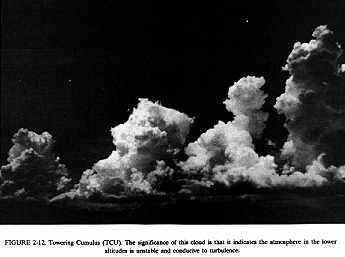
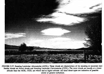
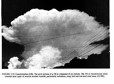
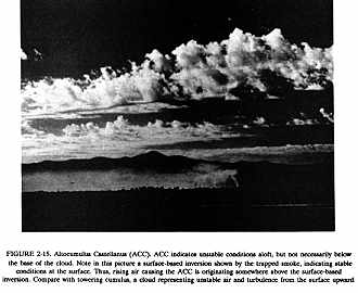
* These cloud types are highly significant and the observer should always report them. Figures 2-12 through 2-17 {2-13, 2-14, 2-15, 2-16} are photographs of these clouds and explain their significance. A pilot in flight should also report them when observed.
 |
FREEZING LEVEL DATA
Freezing level data (from upper air observations) is distributed by
collectives. There are three collectives for the East, Central, and West
sections of the country. The heading for the collectives is UXUSxx KWBC
where the "xx" is 70 for the eastern collective, 71 for the central collective,
or 72 for the western collective. The code used in the collectives follows:
Stn ID Time RADAT UU (D) (hphphp)(hphphp)(/n)
Stn ID and Time - standard 3-letter identifier and observation time.
RADAT - a contraction identifying the data as "freezing level data."
UU - relative humidity at the freezing level in percent. When more than one level is sent, "UU" is the highest relative humidity observed at any of the levels transmitted.
(D) - a coded letter "L," "M," or "H". This indicates that relative humidity is for the "lowest," "middle." or "highest" level coded. This letter is omitted when only one level is sent.
(hphphp) - height in hundreds of feet above MSL at which the sounding crossed the zero degree Celsius isotherm. No more than three levels are coded. If the sounding crosses the zero degree isotherm more than three times, the levels coded are the lowest, highest and the intermediate crossing with the highest relative humidity (RH).
(/n) - indicator to show the number of crossings of the zero degree Celsius isotherm, other than those coded. The indicator is omitted when all levels are coded.
Examples (Station IDs and times omitted):
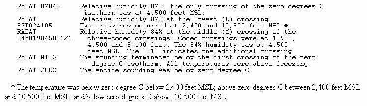 |
* The temperature was below zero degree C below 2,400 feet MSL; above zero degrees C between 2,400 feet MSL and 10,500 feet MSL; and below zero degrees C above 10,500 feet MSL.
REPORT IDENTIFIERS
Individual reports must contain the time and type of report.
Example 1, INK SA 1100...
indicates a relay report from Wink, TX for 1100 UTC. The "SA" signifies a Record hourly.
Example 2, DM SA COR 1100...
signifies a correction to the 1100 UTC Record hourly report as originally transmitted. Corrections transmitted must consist of the entire corrected observation.
Example 3, INK SP 2315...
indicates a Special Report of an observation taken at 2315 UTC to report a significant change in weather.
Supplemental Aviation Weather Reporting Stations (SAWRS) reports are unscheduled and are made by observers at stations not served by a regularly reporting weather station. Observations taken routinely on an hourly observation basis are encoded with an "SA." Observations taken during commercial aircraft operations and whenever mandatory special criteria are met are encoded with an "SP."
READING THE SURFACE AVIATION WEATHER REPORT
Now that we have discussed the individual elements and their decoding, let's read completely each of the reports. Capitalized phrases are those elements which normally are broadcast by the station at or near the airport where the observation was made:
INK SA 1854 CLR 10 106/77/63/1112G18/000
WINK, 1854 ZULU, CLEAR, VISIBILITY ONE ZERO, pressure 1010.6 millibars/hectoPascals, TEMPERATURE SEVEN SEVEN, DEW POINT SIX THREE, WIND ONE ONE ZERO AT ONE TWO GUSTS ONE EIGHT, ALTIMETER THREE ZERO ZERO ZERO.
BOI SA 1854 150 SCT 10 181/62/42/1304/015
BOISE, 1854 ZULU, ONE FIVE THOUSAND SCATTERED, VISIBILITY ONE ZERO, pressure 1018.1 millibars/hectoPascals, TEMPERATURE SIX TWO, DEW POINT FOUR TWO, WIND ONE THREE ZERO AT FOUR, ALTIMETER THREE ZERO ONE FIVE.
MDW RS 1856 -X M7 OVC 11/2R+F 990/63/61/3205/980/ RF2 RB12
CHICAGO MIDWAY, RECORD SPECIAL, 1856 ZULU, SKY PARTIALLY OBSCURED, MEASURED CEILING SEVEN HUNDRED OVERCAST, VISIBILITY ONE AND ONE-HALF, HEAVY RAIN, FOG, pressure 999.0 millibars/hectoPascals, TEMPERATURE SIX THREE, DEW POINT SIX ONE, WIND THREE TWO ZERO AT FIVE, ALTIMETER TWO NINER EIGHT ZERO, TWO TENTHS SKY OBSCURED BY RAIN AND FOG, rain began 12 minutes past the hour.
JFK RS 1853 W5 X 1/4F 180/68/64/1804/006/R04RVR22V30
TWR VSBY 1/2
NEW YORK KENNEDY, RECORD SPECIAL, 1853 ZULU, INDEFINITE CEILING FIVE HUNDRED SKY OBSCURED, VISIBILITY ONE-QUARTER, FOG, pressure 1018.0 millibars/hectoPascals, TEMPERATURE SIX EIGHT, DEW POINT SIX FOUR, WIND ONE EIGHT ZERO AT FOUR, ALTIMETER THREE ZERO ZERO SIX, RUNWAY FOUR RIGHT VISUAL RANGE VARIABLE BETWEEN TWO THOUSAND TWO HUNDRED FEET AND THREE THOUSAND FEET, TOWER VISIBILITY ONE HALF.
LAX SP 1831 7 SCT 250 SCT 3HK 2504/991
LOS ANGELES, SPECIAL, 1831 ZULU, SEVEN HUNDRED SCATTERED, TWO FIVE THOUSAND SCATTERED, VISIBILITY THREE, HAZE, SMOKE, WIND TWO FIVE ZERO AT FOUR, ALTIMETER TWO NINER NINER ONE.
AUTOMATED SURFACE OBSERVATIONS
Automated Surface Observing System (ASOS)
The Automated Surface Aviation Observing System (ASOS) is a joint effort of the NWS, FAA, and the DOD. ASOS is designed to support aviation operations, weather forecasting activities, and at the same time, support the general needs of the hydrometeorological, climatological and meteorological research communities. ASOS will provide continuous minute-by-minute observations and perform the basic observing functions necessary to generate a Surface Aviation Observation (SAO). When fully implemented ASOS will more than double the number of full-time surface aviation weather observing locations (between 900 to 1,700 locations).
While the automated system and the human may differ in their methods of data collection and interpretation, both produce an observation that is similar in form and content. For the "objective" elements such as pressure, ambient temperature, dew point temperature, wind, and precipitation accumulation, both the automated system and the observer use a fixed location and time-averaging technique. For the "subjective" elements, observers use a fixed time, spatial averaging technique to describe the visual elements (sky condition, visibility and present weather), while the automated systems use a fixed location, time-averaging technique. Although this is a fundamental change, the manual and automated techniques yield remarkably similar results within the limits of their respective capabilities.
Among the basic strengths of the ASOS observation is the fact that critical weather parameters (such as sky condition and visibility) are measured at specific locations where they are needed most. ASOS data are updated once each minute and can be accessed through a variety of media never before available from a surface observing site. Computer generated voice messages can be made available through the telephone and directly to the pilot through the ground to air radio.
All ASOS locations will prepare and disseminate SAOs. Some locations operate completely unattended with no human intervention in the generation of the observation. This type of station is designated as "AO2" in the body of the SAO message.
Other locations operate with human on-station oversight and possible intervention in the form of augmentation and/or backup of the SAO message. This type of station is designated as "AO2A" in the body of the SAO message. This means an observer is present at the ASOS location to provide general oversight of the observation. These are referred to as "augmented" sites or observations. At augmented sites, observers will include in the observation some of the weather elements and remarks that the automated systems cannot detect or generate. These elements include thunderstorms, tornadoes, funnel clouds, waterspouts, hail, and freezing rain (when temperatures are near freezing). Some of the remarks the observers will include are those for virga, volcanic ash, and hailstone size. Figure 2-1 is a breakdown of an ASOS observation.
The ASOS will automatically report the following surface weather elements in the SAO:
1. Sky Condition: Cloud Height in hundreds of feet and Amount (CLR, SCT, BKN, OVC) up to 12,000 feet AGL. Ceilings reported as M - measured, E - estimated, W - indefinite, X obscured, and V - variable
2. Visibility up to 10 statute miles
3. Basic Present Weather Information (type and intensity): Rain, Snow, and Freezing Rain (R, S, and ZR). If unable to determine type of light precipitation when temperatures are near freezing, reports P-. Intensities reported in standard form ("-" for light, no symbol for moderate, "+" for heavy)
4. Obstructions to Vision: Fog, Haze
5. Pressure: Sea-level Pressure in millibars/hectoPascals, and Altimeter Setting in inches of mercury
6. Ambient Temperature, Dew Point Temperature (degrees Fahrenheit)
7. Wind: Direction (tens of degrees from true north), speed (knots), character (Gusts, Squalls), and Variability
8. Selected Significant Remarks including: variable ceiling height, visibility, and wind; tower visibility; wind shifts; peak wind; rapid pressure changes; pressure tendency; beginning and ending times of weather, temperature data; precipitation amounts; etc.
Examples of ASOS observations:
IAD SA 1455 A02 CLR BLO 120 M 101/42/41/2804/ 991 $
This observation from Dulles Airport, Washington D.C., indicates at 1455 UTC no clouds below 12,000 feet were detected. The prevailing visibility was missing. The sea-level pressure was 1010.1 millibars/hectoPascals, temperature was 42 degrees F. and dew point 41 degrees F. The winds were from 280 degrees at 4 knots and the altimeter was 29.91 inches. The maintenance flag ($) is automatically appended to the observation to indicate that the site may be in need of maintenance.
JAD RS 1755 AO2A M25 BKN 100 OVC 3TR+ 101/81/75/2820G35/991/RB50 TWR VSBY 1 PCPN 0016 52032 6035/ VSBY W 1/2
Because this ASOS is attended, a thunderstorm is reported in this SAO example. [Because thunderstorms are not reported at an unattended ASOS site, separate messages based on complementary technologies provide information on thunderstorm presence and location(s)]. This report depicts heavy rain, strong gusty winds and a rapidly rising pressure. The 52032 is an additive group denoting pressure tendency and change in the last 3 hours. The pressure change over the past 3 hours in the above observation was 3.2 millibars/hectoPascals. The manually augmented remarks are for tower visibility and lower visibility to the west. The precipitation accumulation since the last hourly SAO report is identified in the "PCPN RRRR" remark, 0.16 inch in the observation above. The 6-hour precipitation accumulation is reported in the "6RRR/" group and is 0.35 inch in the example.
Automated Weather Observing System (AWOS)
The Automated Weather Observing Systems, AWOS III, has been installed by the FAA at selected airports around the country. AWOS operates in four modes: Mode 1: Full-time Automated Operation; Mode 2: Full-time Automated Operation with Local NOTAMs; Mode 3: Full-time Automated Operation w/Manual Weather Augmentation and Local NOTAM Option; and Mode 4: Manual Operation.
The Automated Weather Observing Systems consist of automated reports of ceiling/sky conditions, visibility, temperature, dew point, wind direction/speeds/gusts, altimeter setting, and if certain conditions are met, automated remarks containing density altitude, variable visibility and variable wind direction. A precipitation accumulation sensor is included and coded for longline transmission for use by meteorologists. Automated observations are broadcast on a ground-to-air radio and made available on a telephone answering device. Selected sites will have capability to transmit observations to the Service A teletype network. Figure 2-2 is the breakdown of an AWOS message.
Examples of AWOS observations:
LBL SA 1755 AWOS CLR BLO 120 10 90/56/2008/017
Observation from Liberal, KS, at 1755 UTC, CLR BLO 120 indicates "Clear Below 12,000 feet," visibility 10 miles, temperature 90 degrees F., dew point 56 degrees F., wind from 200 degrees at 8 knots, altimeter 30.17 inches.
FOD SA 2255 AWOS M5 BKN 10 OVC 3/4 32/30/0412/980/ P005/VSBY 3/4V1 1/2 WND 02V08/ WEA: R-ZR-S-F
Observation from Fort Dodge, IA, with a precipitation accumulation report, an automated variable visibility and wind direction remark. An observer appended the manual remarks of light rain, light freezing rain, light snow and fog to the observation.
Automatic Meteorological Observing Station (AMOS)
The AMOS is a solid-state system capable of automatically observing temperature, dew point, wind direction and speed, pressure (altimeter setting), peak wind speed, and precipitation accumulation. The field sensors are tied in directly to the FAA observation network. It transmits a weather report whenever the station is polled by the circuits. At a staffed AMOS, the observer can manually enter additional information to give a more complete observation. Figure 2-3 is the breakdown of an unstaffed AMOS.
PGO SA 1051 AMOS 76/61/0308/007 PK WND 18 013
which decodes as follows:
Observation from Page, OK, at 1051 UTC, temperature 76 degrees F, dew point 61 degrees F, wind from 030 degrees at 8 knots, altimeter setting 30.07 inches, peak wind since the last hourly observation 18 knots, 13 hundredths of an inch of liquid precipitation since the last synoptic observation. Figure 2-4 is the breakdown of a staffed AMOS.
GLS SA 1352 AMOS E12 BKN 150 OVC 6TRW-F 79/77/1103/004 PK WND 15 008/TB32 NW MOVG W
This Galveston, TX, observation contains similar information to the PGO example above but with the addition of sky condition, visibility, and weather and remarks made by an observer.
Examples of a staffed AMOS observation:
GLS SA 1455 AMOS CLR 7 82/71/0311/010 PK WND 15 000
GLS SA 1555 AMOS 11 SCT E100 OVC 7 80/73/0706/996 PK WND 13 028/TCU ALQDS RWU SW
GLS RS 1655 AMOS 7 SCT 15 SCT E60 OVC 7R-78/75/0506/006 PK WND 12 008
Automatic Observing Station (AUTOB)
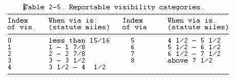
The AUTOB is an AMOS with added capability to automatically report sky conditions, visibility and precipitation occurrence. AUTOB is polled at 20 minute intervals. The upper limit of cloud amount and height measurements is 6,000 feet AGL. Visibility in statute miles is determined by a backscatter sensor with reportable categories of 0 to 8 (Table 2-5). If a visibility report consisting of 3 values is encountered, it is decoded as shown in the following example:
"BV786," 7 = present visibility, 8 = maximum visibility during past 10 minutes, and 6 = minimum visibility during past 10 minutes.
AUTOB may indicate no cloud layers in either a clear situation or when the sensor is unable to penetrate a surface-based obscuration. To distinguish between the two, the following rules apply. If the visibility is less than 2 miles, either partial obscuration "-X" or indefinite obscuration "WX" is reported. A "-X" implies some cloud returns and a "WX" implies no cloud returns. A vertical visibility value for "WX" is not measured. When visibility is 2 miles or greater and no cloud returns are detected a "CLR BLO 60" is used which indicates a clear sky below 6,000 feet. "E" is the ceiling designator. A maximum of 3 (lowest) cloud layers will be reported. Figure 2-5 is the breakdown of an AUTOB message. For example:
DRT SA 1448 AUTOB 25 SCT E40 OVC BV5 P 58/52/1412/995 PK WND 16 004
This Del Rio, TX, observation at 1448 UTC indicates: sky condition of two thousand five hundred scattered, ceiling four thousand overcast, surface visibility was between 4 1/2 and 5 1/2 statute miles, precipitation has occurred within 10 minutes of the observation, temperature 58 degrees F, dew point 52 degrees F, wind from 140 degrees at 12 knots, altimeter setting 29.95 inches, peak wind since the last hourly observation 16 knots, four hundredths (0.04 inches) of liquid precipitation since the last synoptic observation.
Examples of an AUTOB message:
DRT SP 1328 AUTOB CLR BLO 60 BV8 75/65/ 0905/991 PK WND 08 000
DRT SA 1348 AUTOB 25 SCT E30 OVC BV8 83/71/1408/989 PK WND 18 120
DRT SP 1428 AUTOB -X E30 OVC BV1 73/69/ 1307/000 PK WND 10 000 HYR CLDS DETECTED
A remark "HYR CLDS DETECTED" is included if clouds are detected above
an overcast, with the higher clouds "HYR CLDS" being less than 6,000 feet
AGL. Note that an AUTOB makes no distinction between a thin and opaque
cloud layer. "E30 OVC" may be a thin overcast, but is reported as a ceiling.
Remote Automatic Meteorological Observing System (RAMOS)
The breakdown of a RAMOS message is shown in Figure 2-6. Note this is similar to the unstaffed AMOS observation, except for the 3-hour pressure change, maximum/minimum temperature, and 24-hour precipitation accumulation that is included at designated times.
AVIATION ROUTINE WEATHER REPORT (METAR)
A new international weather reporting code (METAR) is now being used by all countries of the world with the exception of the United States and Canada. These two nations will continue to use the code previously described in this section until January 1, 1996. After that date, the new code will be used for weather reports (METAR) and forecasts (TAFs) worldwide.
Although the METAR code is being adopted worldwide, each country is allowed to make modifications or exceptions to the code for use in their particular country, i.e., the U.S. will continue using the current units of measurement (except for temperature and dew point), rather than metric units; the U.S. will continue reporting prevailing visibility rather than lowest sector visibility. Most of the current U. S. observing procedures and policies will continue after the METAR conversion date, with the information disseminated in the METAR code and format. This publication describes how the code will appear in the United States. A METAR report contains the following sequence of elements:
1. Type of report
2. Station designator
3. Time of report
4. Wind
5. Visibility
6. Weather and obstructions to visibility
7. Sky condition
8. Temperature and dew point
9. Altimeter setting
10. Remarks
The following paragraphs describe the elements in a METAR report.
TYPE OF REPORT
There are two types of report - the METAR which is a routine observation report and SPECI which is a Special METAR weather observation. The type of report METAR or SPECI will always appear in the report header or lead element of the report.
STATION IDENTIFIER
The METAR code uses ICAO 4-letter station identifiers. In the contiguous 48 states, the 3-letter domestic station identifier is prefixed with a "K"; i.e., the domestic identifier for Seattle is SEA while the ICAO identifier is KSEA. Elsewhere, the first two letters of the ICAO identifier indicate what region of the world and country (or state) the station is in. For Alaska, all station identifiers start with "PA"; for Hawaii, all station identifiers start with "PH". Canadian station identifiers start with "CU", "CW", "CY", and "CZ"; Mexican station identifiers start with "MM". The identifier for the western Caribbean is "M" followed by the individual country's letter; i.e., Cuba is "MU", Dominican Republic "MD", the Bahamas "MY". The identifier for the eastern Caribbean is "T" followed by the individual country's letter; i.e., Puerto Rico is "TJ". For a complete worldwide listing see ICAO Document 7910, "Location Indicators".
TIME
The time the observation is taken is transmitted as a four digit time group appended with a Z to denote Coordinated Universal Time (UTC).
Example: 1250Z.
WIND
The wind is reported as a five digit group (six digits if speed is over 99 knots). The first three digits is the direction the wind is blowing from in ten's of degrees, or "VRB" if the direction is variable. The next two digits is the speed in knots, or if over 99 knots, the next three digits. If the wind is gusty, it is reported as a "G" after the speed followed by the highest gust reported. The abbreviation "KT" is appended to denote the use of knots for wind speed.
Examples:
13008KT wind from 130 degrees at 8 knots
08032G45KT wind from 080 degrees at 32 knots with gusts to 45 knots.
VRB04KT wind variable in direction at 4 knots
00000KT wind calm
210103G130KT wind from 210 degrees at 103 knots with gusts to 130 knots
If the wind direction is variable by 60 degrees or more and the speed is greater than 6 knots, a variable group consisting of the extremes of the wind direction separated by a "V" will follow the prevailing wind group.
Example: 32012G22KT 280V350
VISIBILITY
Visibility is reported in statute miles with "SM" appended to it.
Examples:
7SM - seven statute miles
15SM - fifteen statute miles
1/2SM - one half statute mile
Runway Visual Range (RVR), when reported, is in the format: R(runway)/(visual range)FT. The "R" identifies the group followed by the runway heading, a "/", and the visual range in feet (meters in other countries).
Example:
R32L/1200FT - runway 32 left visual range 1200 feet
WEATHER
The weather as reported in the METAR code represents a significant change in the way weather is currently reported. In METAR, weather is reported in the format:
Intensity / Proximity / Descriptor / Precipitation / Obstruction to visibility / Other
Note: the "/" above and in the following descriptions (except as the separator between the temperature and dew point) are for separation purposes in this publication and do not appear in the actual METARs.
Intensity - applies only to the first type of precipitation reported. A "-" denotes light, no symbol denotes moderate, and a "+" denotes heavy.
Proximity - applies to and reported only for weather occurring in the vicinity of the airport (between 5 and 10 miles of the center of the airport runway complex). It is denoted by the letters "VC".
Descriptor - these seven descriptors apply to the precipitation or obstructions to visibility.
TS - thunderstorm DR - low drifting
SH - shower(s) MI - shallow
FZ - freezing BC - patches
BL - blowing
Precipitation - there are eight types of precipitation in the METAR code:
RA - rain GR - hail (> 1/4")
DZ - drizzle GS - small hail/snow pellets
SN - snow PE - ice pellets
SG - snow grains IC - ice crystals
Obstructions to visibility - there are eight types of obstructing phenomena in the METAR code:
FG - fog (vsby < 5/8 mile) PY - spray
BR - mist (vsby 5/8 - 6 mi) SA - sand
FU - smoke DU - dust
HZ - haze VA - volcanic ash
Note: fog (FG) is reported only when the visibility is less than five eighths of mile otherwise mist (BR) is reported.
Other - there are five categories of other weather phenomena which are reported when they occur:
SQ - squall SS - sandstorm
DS - duststorm PO - dust/sand whirls
FC - funnel cloud/tornado/waterspout
Examples:
TSRA - thunderstorm with moderate rain
+SN - heavy snow
-RA FG - light rain and fog
BRHZ - mist and haze (vsby > than 5/8 mi)
FZDZ - freezing drizzle
VCSHRA - rain shower in the vicinity
SKY CONDITION
The sky condition as reported in METAR represents a significant change from the way sky condition is currently reported. In METAR, sky condition is reported in the format:
Amount / Height / (Type) or Vertical Visibility
Amount - the amount of sky cover is reported in eighths of sky cover, using the contractions:
SKC - clear (no clouds)
SCT - scattered (1/8 to 4/8's of clouds)
BKN - broken (5/8's to 7/8's of clouds)
OVC - overcast (8/8's of clouds)
Note: A ceiling layer is not designated in the METAR code. For aviation purposes, the ceiling is the lowest broken or overcast layer, or vertical visibility into an obscuration. Also there is no provision for reporting thin layers in the METAR code.
Height - cloud bases are reported with three digits in hundreds of feet.
(Type) - if towering cumulus clouds (TCU) or cumulonimbus clouds (CB) are present, they are reported after the height which represents their base.
Examples:
SCT025TCU BKN080 BKN250
scattered towering cumulus at 2,500 feet, broken clouds at 8,000 feet, broken clouds at 25,000 feet.
SCT008 OVC012CB
scattered clouds at 800 feet, overcast cumulonimbus cloud at 1,200 feet
SKC clear, no clouds
Vertical Visibility - total obscurations are reported in the format "VVhhh" where VV denotes vertical visibility and "hhh" is the vertical visibility in hundred's of feet. There is no provision in the METAR code to report partial obscurations.
Example:
1/8SM FG VV006 - horizontal visibility one eighth of a mile in fog, vertical visibility six hundred feet.
TEMPERATURE/DEW POINT
Temperature and dew point are reported in a two-digit form in degrees Celsius. Temperatures below zero are prefixed with an "M".
Examples:
15/08 - temperature 15 degrees, dew point 8 degrees
00/M02 - temperature zero degrees, dew point minus 2 degrees
ALTIMETER.
Altimeter settings are reported in a four-digit format in inches of mercury prefixed with an "A" to denote the units of pressure.
Example: A2995 - twenty nine point nine five inches of mercury
REMARKS
Remarks are limited to reporting operationally significant weather, the beginning and ending times of certain weather phenomena, and low-level wind shear of significance to aircraft landing and taking off.
The contraction "RMK" precedes remarks. The contraction "RE" is used to denote recent weather events. Wind shear information is denoted by "WS" followed "TKO" for takeoff or "LDG" for landing, and the runway "RW" affected.
Example: RMK REFZDZB45 WS TKO RW04R ReMarks follow, REcent weather event, FreeZing DriZzle Began at 45 minutes after the hour, Wind Shear during TaKe Off RunWay 04 Right.
Examples of METAR reports and explanation:
METAR KBNA 1250Z 33018KT 290V360 1/2SM R31/2700FT +SN BLSNFG VV008 00/M03 A2991 RMK RERAE42SNB42
METAR routine weather report
KBNA Nashville, TN
1250Z time 1250 UTC
33018KT wind from 330 degrees at 18 knots
290V360 wind direction variable between 290 degrees and 360 degrees
1/2SM visibility one half statute mile
R31/2700FT RVR for runway 31 is 2,700 feet
+SN heavy snow
BLSNFG visibility obstructed by blowing snow and fog
VV008 sky obscured with vertical visibility of 800 feet
00/M03 temperature zero degrees Celsius, dew point minus 3 degrees
Celsius
A2991 altimeter setting two nine point nine one inches
RMK remarks follow
RE recent weather events
RAE42 rain ended 42 past the hour
SNB42 snow began 42 past the hour
METAR KSFO 1453Z VRB02KT 3SM MIBR SKC 15/12 A3012
METAR routine weather report
KSFO San Francisco, CA
1453Z time 1453 UTC
VRB02KT wind variable at 2 knots
3SM visibility 3 statute miles
MIBR visibility obstructed by shallow mist (ground fog)
SKC sky clear
15/12 temperature 15 degrees Celsius, dew point 12 degrees Celsius
A3012 altimeter setting three zero point one two inches
SPECI KCVG 2228Z 28024G36KT 3/4SM +TSRA BKN008 OVC020CB 28/23 A3000 RMK RETSB24RAB24
SPECI special weather report
KCVG Cincinnati, OH
2228Z time 2228 UTC
28024G36KT wind from 280 degrees at 24 knots with gusts to 36 knots
3/4SM visibility three fourths of a statute mile
+TSRA thunderstorm with heavy rain
BKN008 OVC020CB broken clouds at 800 feet, overcast cumulonimbus cloud at 2,000 feet
28/23 temperature 28 degrees Celsius, dew point 23 degrees Celsius
A3000 altimeter setting three zero point zero zero inches
RMK remarks follow
RE recent weather event
TSB24 thunderstorm began 24 past the hour
RAB24 rain began 24 past the hour
IAD SA 1155 AO2A CLR BLO 120 5F 101/42/41/2804/991/ 52102 70125 10060 20041
IAD STATION IDENTIFICATION: (Dulles International Airport) Identifies report using 3 or 4 alphanumeric characters (usually airport identifier).
SA TYPE OF REPORT: (Record) See Figure 2-3 for explanation.
1155 TIME OF REPORT: UTC
AO2A TYPE OF STATION: Automated station with precipitation discriminator and augmentation.
CLR BLO 120 SKY AND CEILING: (No clouds were detected below 12,000 feet AGL)
Determined from a laser ceilometer every 30 seconds over a 30 minute period.
5 PREVAILING VISIBILITY: (Measured visibilities equal to or greater than
5 and less than 7 statute miles). Determined from a visibility sensor once every 30 seconds and is used to compute a one-minute average. The one-minute visibility values are then averaged over a 10 minute period to determine the reported (prevailing) visibility.
F WEATHER AND OBSTRUCTIONS TO VISION: (fog) When visibility drops below 7 statute miles, the current Dew Point Depression (DD) will be used to distinguish between Fog and Haze. If the DD is less than or equal to 4 degrees F, then F will be reported as the obstruction to vision.
101 SEA-LEVEL PRESSURE: (1010.1 millibars/hectoPascals) Only the tens, units, and tenths digits are reported. To decode, prefix the value with a 9 or 10, whichever brings the value closest to 1000 millibars/hectoPascals.
42 TEMPERATURE: (42 degrees F.) See Figure 2-3 for explanation.
41 DEW POINT: (41 degrees F.) See Figure 2-3 for explanation.
2804 WIND: (280 degrees true north at 4 knots) See Figure 2-3 for explanation
The current 2 minute average wind is computed once every 5 seconds.
991 ALTIMETER SETTING: (29.91 inches) See Figure 2-3 for explanation.
52102 PRESSURE TENDENCY, 5appp: (steadily rising, 10.2 millibars/ hectoPascals higher than three hours ago.) See note on bottom of Figure 2-6.
70125 24-HOUR PRECIPITATION 7RRRR: (1.25 inches of precipitation, liquid equivalent, in the past 24 hours.)
10060 MAXIMUM TEMPERATURE 1sTTT: (60 degrees F.) The maximum temperature during the past 6 hours.
20041 MINIMUM TEMPERATURE 2sTTT: (41 degrees F.) The minimum temperature during the past 6 hours.
NOTE: Refer to ASOS GUIDE FOR PILOTS and the AIRMAN'S INFORMATION MANUAL for more information. Refer to the AIRPORT/FACILITY DIRECTORY, aeronautical charts, and related publications for broadcast, telephone and location data. Check "Notices to Airmen" for ASOS system status. Density Altitude will be included on voice broadcast only when 1000 or more feet above airport elevation.
FIGURE 2-1. Decoding observations from ASOS stations.
FOD SA 0055 AWOS M5 OVC 1/2 70/68/3325G30/992/ P110/WND 30V36/WEA: TRW+
T OVHD
FOD STATION IDENTIFICATION: (Fort Dodge, IA)
SA TYPE OF REPORT: (Record) See Figure 2-3 for
explanation.
0055 TIME OF REPORT: UTC.
AWOS AUTOMATIC STATION IDENTIFIER.
M5 OVC SKY AND CEILING: (Measured 500 feet overcast) Determined from
sensor every 30 seconds and integrated over a 30-minute sampling period.
1/2 PREVAILING VISIBILITY: (One-half statute mile) Determined from sensor outputs every 10-second intervals that are used to compute a one-minute average. The one-minute visibility values are averaged over a 10-minute period to determine the reported visibility. Visibility greater than 10 statute miles not reported.
70 TEMPERATURE: (70 degrees F.) A 5-minute average reading.
68 DEW POINT: (68 degrees F.) A 5-minute average reading.
3325G30 WIND: (330 degrees true at 25 knots, gust to 30 knots) Direction is the first two digits and is reported in tens of degrees and the second two digits is the speed. The "G" stands for wind gust and the last two digits is the highest 5-second average wind speed for the past 10 minutes.
992 ALTIMETER SETTING: (29.92 inches) See Figure 2-3 for an explanation.
P110 PRECIPITATION ACCUMULATION: (1.10 inches) The cumulative amount
or liquid equivalent precipitation. Reported on each observation it is
an accumlation reported to the nearest 0.01 inch in inches/tenths/hundredths
and
prefixed with the letter "P".
WND 30V36 AUTOMATED REMARK: (Wind direction variable between 300 degrees
and 360 degrees true. Variable wind direction is reported when the wind
direction varies around the reported direction by 60 degrees or more with
the wind
speed is 7 knots or greater.
WEA: MANUAL WEATHER AUGMENTATION: (Thunderstorm with heavy rain shower
TRW+ directly over the station) This example indicates that the weather
T OVHD observer at the station reports a thunderstorm with a heavy rain
shower
directly over the station. The data that can be added to the report
is limited to thunderstorms (their intensity and direction), obstructions
to visibility (dependent on the visibility being 3 miles or less) and precipitation
(type and intensity).
NOTE: Refer to the AIRMAN'S INFORMATION MANUAL for more information.
Refer to the AIRPORT/FACILITY DIRECTORY, aeronautical charts, and related
publications for broadcast, telephone, and location data. Check NOTICES
TO AIRMEN for AWOS system units.
 |
 |
NOTE: In THREE-HOUR PRESSURE CHANGE the first digit is the barometer
tendency. The tendency is higher than three hours ago if the digit is 0,
1, 2 or 3. The pressure is lower than three hours ago if the digit is 5,
6, 7 or 8 and if the digit is a 4, no change has occurred in the last three
hours.