AVIATION WEATHER FORECASTS
Note: For information on an important future change in the aviation weather reporting and forecasting system, see the Aviation Routine Weather Report (METAR) and International Terminal Aerodrome Forecast (TAF).
Good flight planning involves considering all available weather information, including weather forecasts. This section explains the following aviation forecasts:
1. Terminal Forecasts
(a). Domestic (FT)
(b). International (ICAO TAF)
2. Aviation Area Forecast (FA)
3. Convective SIGMET (WST)
4. SIGMET and AIRMET (WS and WA)
5. TWEB Route Forecast and Synopsis
6. Winds and Temperatures Aloft Forecast (FD)
7. Special Flight Forecasts
8. Center Weather Service Unit (CWSU) Products
Also discussed are the following general forecasts which may aid in flight planning:
1. Hurricane Advisory (WH)
2. Convective Outlook (AC)
3. Severe Weather Watch Bulletins (WW) and Alert Messages (AWW)
TERMINAL FORECASTS (FT and TAF)
TERMINAL FORECAST FT (Domestic)
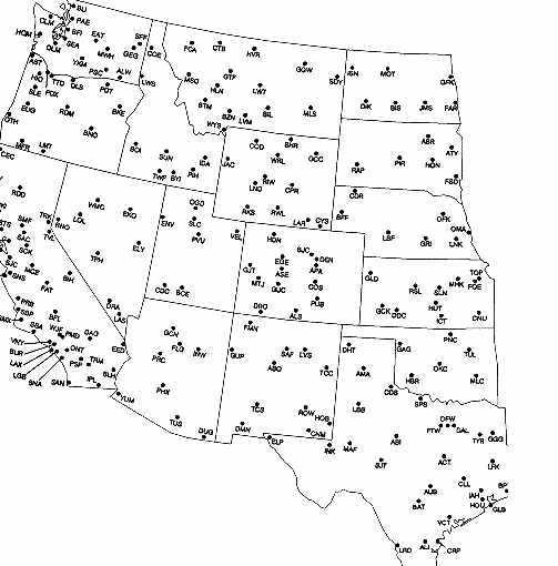
A Terminal Forecast (FT) is a description of the weather conditions expected to occur at an airport and within a 5 nautical mile radius of the runway complex. Terminal Forecasts are valid for a 24-hour period. Figures 1-5A through 1-5C {1-5B} depicts the locations where FTs are issued three times daily. Issuance and valid times are according to time zones. Section 15 contains a listing of the issuance and valid times of the FTs. The format of the FT is similar to the SAO (Surface Aviation Observation) report. All times in FTs are Universal Coordinated Time (UTC or Z times).
FT REQUIREMENTS
In order for a forecast to be issued for a terminal, a minimum of two consecutive, complete, routine observations are required from that terminal. This includes terminals with automated weather observations. If for some reason, complete observations are not available from an terminal, the contractions "NO UPDTS AVBL" (no updates available) or "FT NOT AVBL" (FT not available) will appear in the FT to alert users. For those terminals which are routinely open part-time only, the FT for these terminals will include the statement "NO UPDTS AFT (time)Z" or "NO UPDTS TIL (time)Z" [no updates after (time)Z or no updates until (time)Z] where "(time)Z" is the hour the terminal closes for the day [AFT (time)Z] or opens for the day and the two required observations have been received [TIL (time)Z]. If the required observations are not available at the routine FT issuance time, the contraction "FT DLAD" (FT delayed) is sent out for that terminal.
FT FORMAT
FTs are issued in the following format:
iii FT DDTTTT 1st forecast group.
TTZ 2nd forecast group.
TTTTZ 3rd forecast group.
.
TTZ Last forecast group..
The "iii" is the station identifier. "DDTTTT" is the date (DD) and valid period (TTTT) of the forecast. "TTZ" or "TTTTZ" indicates a forecast change group. Note that after the first forecast group, each succeeding forecast group is on a separate line and set in from the left margin. This helps in reading the FT. The number of forecast groups will depend on the complexity of the forecast for that terminal. The period "." at the end of each forecast group indicates the end of that particular forecast group. The last forecast group ends with two periods ".." which indicates the end of the FT itself.
FT CONTENTS
FTs contain the following elements...
LOCATION / TYPE / VALID DATE TIME / FORECAST
Note: the "/" above in the following descriptions are for separation purposes in this publication and do not appear in the actual FTs.
The following are descriptions of the above FT elements:
LOCATION
This is the standard U.S. three letter identifier for the terminal the forecast is issued for.
TYPE
The letters "FT" will always appear here. If it is a routine issuance, this is all that will appear. For delayed, corrected, or updated FTs, the appropriate contraction will appear next (see Unscheduled FTs discussion).
VALID DATE TIME
This is a six digit group, the first two digits is the date the valid period begins. The next four digits are the valid period of the forecast. For routine issuances, this is a 24-hour period. For other types of FTs, this may be less than a 24-hour period. If the FT is delayed, corrected, or updated, the issue time will follow the valid date time (see Unscheduled FTs discussion).
FORECAST
The forecast portion of FTs includes:
Sky Condition / Visibility / Weather and/or Obstructions to Visibility / Wind / Remarks
These elements are described below:
Sky Condition - the height of cloud bases are forecast in hundreds of feet above ground level. Cloud amounts are forecast in tenths of sky cover. The contractions for sky cover are:
CLR (clear) - less than 1/10 cover
SCT (scattered) - 1/10 to 5/10's cover
BKN (broken) - 6/10's to 9/10's cover
OVC (overcast) - 1.0 or complete cover.
If a thin cloud layer is expected, it is noted by a "-" between the cloud height and cloud amount. If a ceiling is expected, the ceiling layer will be prefixed with the letter "C". A partially obscured sky is noted by a "-X" prior to the actual sky cover forecast. A totally obscured sky is forecast by an "X" preceded by a "C" to denote this as a ceiling.
Visibility - visibility is forecast in statute miles. If the prevailing visibility is expected to be 6 miles or more, a visibility forecast is not included in the FT.
Weather and/or Obstructions to Visibility - if a weather phenomena or an obstruction to visibility of significance to aviation operations are expected, they will be included as the prevailing conditions in the FT. The following tables contain the weather and obstructions to visibility which may appear in an FT.
TABLE 4-1. FT Weather
---------------------------------------------
R RAIN ZR FREEZING RAIN
S SNOW ZL FREEZING DRIZZLE
RW RAIN SHOWER IP ICE PELLETS
SW SNOW SHOWER IC ICE CRYSTALS
T THUNDERSTORM A HAIL
L DRIZZLE IPW ICE PELLET SHOWERS
SG SNOW GRAINS SP SNOW PELLETS
---------------------------------------------
Precipitation intensities are forecast using the following symbols:
Light -
Moderate (no sign)
Heavy +
A severe thunderstorm is forecast as "T+." A severe thunderstorm is one in which the surface wind is 50 knots or greater and/or surface hail is 3/4 inch or more in diameter.
Obstructions to vision include the phenomena listed in Table 4-2. No intensities are reported for obstructions to vision.
TABLE 4-2. FT Obstructions to Visibility
-------------------------------------------
F FOG BD BLOWING DUST
GF GROUND FOG BN BLOWING SAND
H HAZE BS BLOWING SNOW
K SMOKE IF ICE FOG
D DUST VOLCANIC ASH WRITTEN OUT
-------------------------------------------
Wind - the wind is forecast by direction and speed. The direction is forecast in tens of degrees relative to true north. The speed is forecast in knots. Wind gusts are noted by a "G" after the speed followed by the peak gust expected. If a speed of less than 6 knots is expected, a wind forecast is not included in the FT.
Remarks - remarks are added to a forecast group to amplify or describe expected weather conditions which differ from those forecast as the prevailing conditions. The remark "LLWS" for low level wind shear is used when a significant change or shear in wind direction or speed is expected within 2000 feet of the surface. If the magnitude and duration of the expected shear is known, it may be included with the LLWS remark. The conditional remark "OCNL" for occasional is used to describe those conditions which have a high probability (greater than 50%) of occurring, but are expected to last for a period of time less than one-half of the forecast period. Thus if a forecast period is 6 hours long, an occasional condition during that period is expected to last less than 3 hours. The "OCNL" remark is used for differing sky and visibility conditions and for precipitation and thunderstorm events.
The probability remark "CHC" for chance is used only with expected precipitation and thunderstorms events and not within 6 hours of the FT issuance. The probability of occurrence of these events is 30 to 49 percent.
The remark "VCNTY" for vicinity is used to describe dense fog (visibility below 3 miles), showers or thunderstorms that develop, or are expected to develop, beyond the FTs 5 nautical mile radius out to about 25 miles, which may directly affect operations to and from the airport.
Frontal passages are also a form of remarks used in FTs, however they appear immediately after the time in the forecast change group the front is expected to pass the terminal. The contractions for frontal passages are:
CFP - cold frontal passage
WFP - warm frontal passage
OCF - occluded frontal passage
An example of frontal passage in an FT:
OKC FT 112222 C20 BKN 1610 OCNL 20 SCT 01Z CFP 40 SCT 3110 etc...
In this example, a cold front is expected to pass through Oklahoma City around 0100Z with improving conditions behind the front.
SCHEDULED FT COLLECTIVES
FT's are normally issued in a collective by forecast areas. The heading of an FT collective identifies the message as an FT along with a 6-digit date-time group giving the transmission time. For example, "FT130945" means a collective transmitted on the 13th at 0945Z. A collective FT message will usually be broken down into states, i.e. "TX 130945" would be followed by a group of FTs for terminals in the state of Texas.
UNSCHEDULED FTS
Delayed, corrected, or amended FTs are FTs which are issued at times other than the normal issuance times. An unscheduled FT is identified in the message rather than in the heading. The following are examples of a delayed FT for Binghamton, NY, a corrected FT for Memphis, TN, and an amended FT for Lufkin, TX.
BGM FT RTD 131615 1620Z 100 SCT 1810. etc.
MEM FT COR 132222 2230Z 40 SCT 300 SCT OCNL TRW. etc.
LFK FT AMD 131410 1425Z C8 OVC 4F OVC OCNL BKN. etc.
Note in each forecast a time group follows the valid period. This time group is the forecast issue time.
A routine delayed FT (RTD) is issued for those terminals not on a 24-hour observing schedule. When the first two complete observations of the day are received, an RTD FT is issued. For example, the BGM delayed forecast was issued at 1620Z and not at the scheduled issuance time of 1445Z. This changes the beginning of the valid forecast period from 1500Z to 1600Z. After this, the FT is issued at the normal times.
A corrected FT (COR) is issued when an FT contains typographical or other errors. For example, the FT for MEM was issued at the normal issuance time of 2145Z. After the FT had gone out, an error in the FT was noted, so a correction was issued at 2230Z The valid time remains the same as in the original FT.
An amended or updated FT (AMD) is necessary for a situation in which the forecast has to be revised due to significant changes in the weather. For example the original FT issued for LFK at 0945Z was not verifying, so an amended forecast was issued at 1425Z. In this case, the valid period of the amended forecast begins at the hour nearest the issuance time and continues until the end of the valid period of the original FT.
FTS FOR AUTOMATED OBSERVATION LOCATIONS
FTs are issued for automated observations sites when the local NWS Manager feels there is sufficient, reliable information available through augmentation or other means and that representative weather conditions at the site can be determined by the forecasters. This may include non-augmented automated observation sites.
At those sites where the automated observations are augmented on a part-time basis, the statement "UPDTS LIMITED TO CIG AND VSBY (AFT TTZ, or TIL TTZ, or TTZ-TTZ)" will be included with last FT issued for that site each day. When users see this statement in an FT, they should not expect updates for thunderstorms and/or freezing precipitation for the times shown by the qualifiers AFT (after), TIL (until), or the period from TTZ-TTZ for that terminal. Updates may still be issued for changes in ceilings and visibilities.
Example of an FT:
MEM FT 121818 C30 BKN 5H 2012.
20Z C30 BKN 5H 2012 OCNL C8 OVC 1TRW.
02Z CFP C15 BKN 25 OVC 3315G20 OCNL 3RW.
04Z C8 OVC 3512 CHC 2R-S-.
10Z C12 BKN 0208.
12Z CLR 3F OCNL 1/2F.
16Z CLR..
This is a routine FT for Memphis, TN, issued on the 12th and is valid from 1800Z until 1800Z the next day.
The first forecast group calls for a ceiling of 3,000 feet broken, visibility 5 miles in haze, and a wind from 200 degrees at 12 knots.
The second forecast group includes after 2000Z, an occasional thunderstorm with a ceiling 800 feet overcast and a visibility of 1 mile in moderate rain showers. In this case the forecast period is 6 hours long (20Z until 02Z), but the occasional conditions with the thunderstorms will last less than 3 hours (half of the forecast period).
The third forecast group expects a cold front passage within 30 minutes either side of 02Z bringing in ceilings 1,500 feet broken and 2,500 feet overcast. The wind shifts, coming from 330 degrees at 15 knots with gusts to 20 knots. Occasional periods of moderate rain showers reducing visibility to 3 miles is expected. In this case, the prevailing visibility is expected to be 6 miles or more, so it is not included with the forecast. The fourth forecast group begins around 0400Z and lowers ceilings to 800 feet overcast. The wind is from 350 degrees at 12 knots and there is a chance (less than 50 percent) of a mixture of light rain and light snow reducing visibilities to 2 miles.
The fifth forecast group begins around 10Z with conditions improving to ceilings 1,200 feet broken and wind from 020 degrees at 8 knots.
The sixth forecast group begins around 12Z with skies going clear, with fog forming, reducing prevailing visibility to 3 miles and occasionally to one half mile. The wind speed is expected to be less than 6 knots so a wind forecast is not included with this forecast group.
The seventh and last forecast group (note the ".."s) expects clear skies until the end of the valid period of the FT (1800Z).
INTERNATIONAL TERMINAL AERODROME FORECAST (TAF)
On July 1, 1993, a new, revised Terminal Aerodrome Forecast (TAF) format and code replaced the existing TAF code. This new code is in effect in most countries. The exceptions are the United States and Canada. These two countries issue Terminal Forecasts for domestic use and TAFs for the military and those airports serving international aviation.
On January 1, 1996 the U.S. and Canada will convert entirely to the new TAF code. After that date, the new code for weather reports (METAR) and TAFs will be used worldwide. The North American code used in the FT (and SAO) will be discontinued. Although the new TAF code is being adopted worldwide, each country is allowed to make modifications or exceptions to the code for use in each particular country. The TAF code, as described here, is the one used in the United States for those airports serving international aviation and will also be used after the January 1, 1996 conversion date. The World Meteorological Organization's (WMO) publication No. 782 "Aerodrome Reports and Forecasts" contains the base METAR and TAF code as adopted by the WMO member countries.
TAFs are forecasts for international flights and use the same code used in the METAR weather reports. See Section 2 for a description of the METAR code. They are scheduled four times daily for 24-hour periods beginning at 0000Z, 0600Z, 1200Z, and 1800Z. See Section 15 for issuance times.
A TAF is a concise statement of the expected meteorological conditions at an airport during a specified period (usually 24 hours). TAFs are issued in the following format:
TYPE LOCATION / ISSUANCE TIME / VALID TIME / FORECAST
Note: the "/" above and in the following descriptions are for separation purposes in this publication and do not appear in the actual TAFs.
The following is a description of the above elements which make up a TAF
TYPE
There are two types of TAF issuances, a routine forecast issuance (TAF) and an amended forecast (TAF AMD). An amended TAF is issued when the current TAF no longer adequately describes the on-going weather or the forecaster feels the TAF is not representative of the current or expected weather. Either TAF or TAF AMD appears as a separate product header line before the text of the forecast.
Corrected (COR) or delayed (RTD) TAFs are identified only in the communications header which precedes the actual forecasts.
LOCATION
The TAF code uses ICAO 4-letter location identifiers. In the contiguous 48 states, the 3-letter domestic location identifier is prefixed with a "K"; i.e., the domestic identifier for Seattle is SEA while the ICAO identifier is KSEA. Elsewhere, the first two letters of the ICAO identifier indicate what region of the world and country (or state) the station is in. For Alaska, all station identifiers start with "PA"; for Hawaii, all station identifiers start with "PH". Canadian station identifiers start with "CU", "CW", "CY", and "CZ"; Mexican station identifiers start with "MM". The identifier for the western Caribbean is "M" followed by the individual country's letter; i.e., Cuba is "MU", Dominican Republic "MD", the Bahamas "MY". The identifier for the eastern Caribbean is "T" followed by the individual country's letter; i.e., Puerto Rico is "TJ". For a complete worldwide listing see ICAO Document 7910, "Location Indicators".
ISSUANCE DATE/TIME
This is a 6-digit group giving the date (first two digits) and time (last four digits) in UTC the forecast is issued.
VALID PERIOD
This is a four-digit group which gives the valid period, usually 24 hours, of the forecast in UTC. In the case of an amended forecast, or a forecast which is corrected or delayed, the valid period may be for less than 24 hours. Where an airport or terminal operates on a part time basis (less than 24 hours/day), the TAFs issued for those locations will have the abbreviated statement "AMD NOT SKED AFT (closing time) UTC" added to their forecasts. For the TAFs issued while these locations are closed, the word "NIL" will appear in place of the forecast text. A delayed (RTD) forecast will then be issued for these locations after two complete observations are received.
FORECAST
This is the body of the TAF. The basic format is:
WIND / VISIBILITY / WEATHER / SKY CONDITION
The wind, visibility, and sky condition elements are always included in the initial time group of the forecast. Weather is included only if significant to aviation.
If a significant, lasting change in any of the elements is expected during the valid period, a new time period with the changes is included. It should be noted that the new time period will include only those elements which are expected to change, i.e., if a lowering of the visibility is expected but the wind is expected to remain the same, the new time period reflecting the lower visibility would not include a forecast wind. The forecast wind would remain the same as in the previous time period.
Any temporary conditions expected during a specific time period are included with that time period. The following describes the elements in the above format.
WIND - this five (or six) digit group includes the expected wind direction (first 3 digits) and speed (last 2 digits or 3 digits if 100 knots or greater). The contraction "KT" follows to denote the units of wind speed. Wind gusts are noted by the letter "G" appended to the wind speed followed by the highest expected gust.
A variable wind direction is noted by "VRB" where the three digit direction usually appears. A calm wind (3 knots or less) is forecast as "00000KT".
Examples:
18010KT - wind forecast from 180 degrees at 10 knots.
35012G20KT - wind forecast from 350 degrees at 12 knots with gusts to 20 knots.
VISIBILITY - the expected prevailing visibility up to and including 6 miles is forecast in statute miles, including fractions of miles, followed by "SM" to note the units of measure. Expected visibilities greater than 6 miles are forecast as a Plus 6SM.
Examples:
1/2SM - visibility one-half statute mile
4SM - visibility four statute miles
P6SM - visibility greater than 6 statute miles
WEATHER - weather phenomena significant to aviation are forecast in the following format in TAFs:
Intensity or Proximity / Descriptor / Precipitation / Obstruction to Visibility / Other
Intensity - in the TAF, intensities are noted by a "-" for light, no symbol for moderate, and "+" for heavy. These intensity symbols apply to precipitation only.
Proximity - this applies to weather conditions expected to occur in the vicinity of the airport (between a 5 to 10 statute mile radius of the airport), but not at the airport itself. It is denoted by the letters "VC".
Descriptor - there are seven descriptors which apply to forecast precipitation and/or obstructions to visibility.
TS - thunderstorm DR - low drifting
SH - shower MI - shallow
FZ - freezing BC - patches
BL - blowing
Precipitation - there are five types of precipitation forecast in TAFs.
RA - rain GR - hail (> 1/4")
SN - snow GS - small hail/snow pellets
PE - ice pellets
Note: for automated observing stations, UP for unknown precipitation type will be forecast.
Obstructions to Visibility - there are eight types of obstructing phenomena forecast in TAFs.
FG - fog (vsby < 5/8 mile) PY - spray
BR - mist (vsby 5/8 - 6 mi) SA - sand
FU - smoke DU - dust
HZ - haze VA - volcanic ash
Note: Fog (FG) is forecast only when the visibility is expected to be less than five-eighths of mile, otherwise mist (BR) is forecast.
Other - there are five other weather phenomena which are included in TAFS.
SQ - squall SS - sandstorm
DS - duststorm. PO - dust/sand whirls
FC - funnel cloud/tornado/waterspout
Examples of forecast weather:
+TSRA - thunderstorm with heavy rain
SNRA - snow and rain mixed
RA FG - rain and fog (note the space)
FUHZ - smoke and haze
FZRA - freezing rain
If no significant weather is expected to occur during a specific time period in the forecast, the weather group is omitted for that time period. If, after a time period in which significant weather is forecast, a change to a forecast of no significant weather occurs, the contraction NSW (No Significant Weather) will appear as the weather group in the new time period.
SKY CONDITION - sky condition is forecast in TAFs in the following format:
Amount / Height / (Type) or Vertical Visibility
Amount - the expected amount of sky cover is forecast in eighths of sky cover, using the contractions:
SKC - clear (no clouds or less than 1/8 clouds)
SCT - scattered (1/8 to 4/8s of clouds)
BKN - broken (5/8s to 7/8s of clouds)
OVC - overcast (sky totally covered)
Note: Ceiling layers are not designated in the TAF code. For aviation purposes, the ceiling is the lowest broken or overcast layer or vertical visibility into an obscuration.
Height - the bases of expected clouds layers are forecast with three digits in hundreds of feet.
Examples:
SCT008 BKN020 OVC100 - scattered clouds at 800 feet, broken clouds at 2,000 feet, overcast clouds at 10,000 feet.
SKC - clear, no clouds
(Type) - if cumulonimbus clouds are expected at the airport, the contraction "CB" is appended to the cloud layer which represents the base of the cumulonimbus cloud(s). Cumulonimbus clouds are the only cloud type forecast in TAFs.
Example:
SCT050 BKN025CB BKN250 - scattered clouds at 500 feet, broken cumulonimbus cloud(s) at 2,500 feet, broken clouds at 25,000 feet.
Vertical Visibility - when the sky is totally obscured, vertical visibility into the obscuration is forecast in the format "VVhhh" where VV denotes vertical visibility and "hhh" is the expected vertical visibility in hundred's of feet. There is no provision in the TAF code to forecast partial obscurations.
Example:
1/2SM FG VV012 - vertical visibility 1,200 feet (with horizontal visibility one half mile in fog).
PROBABILITY FORECAST
A PROB40 (PROBability) HHhh group in a TAF indicates the probability of occurrence of thunderstorms or other precipitation events. The PROB group is used when the occurrence of thunderstorms or precipitation is in the 30% to less than 50% range, thus the probability value 40 is appended to the PROB contraction. This is followed by a four digit group giving the beginning time (HH) and ending time (hh) of the time period during which the thunderstorms or precipitation is expected. Following this will be the conditions expected with the thunderstorms and/or precipitation.
Examples:
PROB40 2102 1/2SM +TSRA OVC005CB - between the hours of 2100Z and 0200Z, there is a 40 percent probability of conditions of five hundred feet overcast in a cumulonimbus cloud, visibility one half mile in a thunderstorm with heavy rain.
PROB40 1014 1SM RASN - between the hours of 1000Z and 1400Z, a chance (40%) of rain and snow mixed reducing visibility to one mile is expected.
TEMPORARY CONDITIONS
When temporary conditions are expected to occur during the forecast valid period, a TEMPO (TEMPOrary) HHhh group indicates this.
The TEMPO group is used for any conditions in wind, visibility, weather, or sky condition which are expected to last for generally less than an hour at a time. The time period during which the temporary conditions are expected are given by a four-digit group giving the beginning time (HH) and ending time (hh) of the time period following the TEMPO indicator.
Examples:
SCT030 TEMPO 1923 BKN030 - predominant sky condition is scattered clouds at 3,000 feet, but between the hours of 1900Z and 2300Z, broken clouds at 3,000 feet will exist for periods of less than one hour.
4SM HZ TEMPO 1215 2SM BRHZ - prevailing visibility is 4 miles in haze, but between the hours of 1200Z and 1500Z, visibility of 2 miles in mist (fog) and haze is expected for periods of less than one hour.
FORECAST CHANGE GROUPS
A significant, permanent change in existing conditions during the valid period of the TAF is indicated by the change groups FMHH (FroM) and BECMG (BECoMinG) HHhh.
The FMHH change group is used when a rapid change, usually less than one hour, in conditions is expected. The hour (HH) the change is expected is appended to the FM indicator.
Example:
... BKN030 FM01 SKC...
Prior to 0100Z the sky condition is broken clouds at 3,000 feet. Around 0100Z, the sky condition will change to clear and will continue until the next change group or until the end of the current forecast.
The BECMG HHhh change group is used when a gradual change in conditions is expected over a longer time period, usually two hours. The times the change is expected is a four-digit group with the beginning (HH) and ending times (hh) of the change period which follows the BECMG indicator.
Example:
... 3SM BR OVC012 BECMG 1416 5SM HZ BKN020...
Prior to 1400Z the visibility is 3 miles in mist and the sky condition
is overcast clouds at 1,200 feet. During the hours from 1400Z to 1600Z,
a gradual change to visibility of 5 miles in haze and broken clouds at
2,000 feet is expected and will continue until the next change group or
the next forecast.
AVIATION AREA FORECAST (FA)
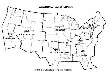
An aviation Area Forecast (FA) is a forecast of general weather conditions over an area the size of several states. It is used to determine forecast en route weather and to interpolate conditions at airports which do not have FTs issued. Figure 1-4 maps the FA areas. FAs are issued 3 times a day by the National Aviation Weather Advisory Unit (NAWAU) in Kansas City, MO, for each of the 6 areas in the contiguous 48 states. In Alaska, FAs are issued by the WSFOs in Anchorage, Fairbanks, and Juneau for their respective area (Figure 1-4A) and utilized a different format (see "Alaska Area Forecasts"). The WSFO in Honolulu issues FAs for Hawaii (Figure 1-4A). A specialized FA for the Gulf of Mexico is issued by the National Hurricane Center in Miami, FL. This product combines both aviation and marine information and is intended to support offshore helicopter operations. The Gulf of Mexico FA focuses on an area which includes the coastal plains and coastal waters from Apalachicola, FL to Brownsville, TX, and the offshore waters of the Gulf of Mexico, in an area west of 85W and north of 27N.
An example of an Aviation Area Forecast (FA):
SLCC FA 141045
SYNOPSIS AND VFR CLDS/WX
SYNOPSIS VALID UNTIL 150500
CLDS/WX VALID UNTIL 142300 ... OTLK VALID 142300-150500
ID MT NV UT WY CO AZ NM
SEE AIRMET SIERRA FOR IFR CONDS AND MTN OBSCN.
TSTMS IMPLY PSBL SVR OR GTR TURBC SVR ICG LLWS
AND IFR CONDS.
Example of TAF with decoding by heading and time groups:
TAF
KMEM 121720Z 1818 20012KT 5SM HZ BKN030 PROB40 2022 1SM TSRA OVC008CB FM22 33015G20KT P6SM BKN015 OVC025 PROB40 2202 3SM SHRA FM02 35012KT OVC008 PROB40 0205 2SM -RASN BECMG 0608 02008KT NSW BKN012 BECMG 1012 00000KT 3SM BR SKC TEMPO 1214 1/2SM FG FM16 VRB04KT P6SM NSW SKC.
TAF KMEM 121720Z 1818 - TAF issued for Memphis, TN on the 12th at 1720Z and valid for a 24 hour period from 1800Z to 1800Z.
20012KT 5SM HZ BKN030 PROB40 2022 1SM TSRA OVCOO8CB - forecast for the hours from 1800Z to 2200Z (beginning of next time period), wind from 200 degrees at 12 knots, visibility 5 statute miles in haze, broken clouds at 3,000 feet. A chance (40%) of thunderstorm with moderate rain, visibility 1 statute mile, and overcast sky at 800 feet by cumulonimbus cloud.
FM22 33015G20KT P6SM BKN015 OVC025 PROB40 2202 3SM SHRA - forecast for the hours from 2200Z to 02007, wind from 330 degrees at 15 knots with gusts to 20 knots, visibility greater than 6 statute miles, broken clouds at 1,500 feet, overcast clouds at 2,500 feet. Between the hours of 2200Z and 0200Z, a chance (40%) of visibility 3 statute miles in moderate rain showers.
FM02 35012KT OVC008 PROB40 0205 2SM -RASN - forecast for the hours from 0200Z to 0600Z, wind from 350 degrees at 12 knots, overcast clouds at 800 feet. Between the hours of 0200Z and 0500Z, a chance (40%) of visibility 2 statute miles in light rain and snow mixed. Note: the prevailing visibility is not expected to change from P6SM forecast in the previous time period, so a visibility forecast is not included after the wind forecast.
BECMG 0608 02008KT NSW BKN012 - between 0600Z and 0800Z conditions forecast to become wind from 020 degrees at 8 knots, no significant weather, broken clouds at 1,200 feet with conditions continuing until 1000Z.
BECMG 1012 00000KT 3SM BR SKC TEMPO 1214 1/2SM FG - between 1000Z and 1200Z conditions forecast to become wind calm, visibility 3 statute miles in mist, with clear skies. Between the hours of 1200Z and 1400Z visibility temporarily 1/2 statute mile in fog. Conditions continuing until 1600Z.
FM16 VRB04KT P6SM NSW SKC - from 1600Z until the end of the forecast (1800Z), wind variable in direction at 4 knots, visibility greater than 6 statute miles, no significant weather, and sky clear.
-----------------------------------------------------------------------------
NON MSL HGTS ARE DENOTED BY AGL OR CIG.
SYNOPSIS ... HIGH PRES OVER NERN MT CONTG EWD GRDLY. LOW PRES OVR AZ NM AND WRN TX RIVING GENLY STNRY. ALF ... TROF EXTDS FROM WRN MT INTO SRN AZ RIVING STNRY..
.
ID MT
FROM YXH TO SHR TO 30SE BZN TO 60SE PIH TO LKT TO YXC TO YXH.
70-90 SCT-BKN 120-150. WDLY SCT RW-. TOPS SHWRS 180. OTLK...VFR
RMNDR AREA...100-120. ISOLD RW- MNLY ERN PTNS AREA. OTLK..VFR.
.
UT NV NM AZ
80 SCT-BKN 150-200. WDLY SCT RW-/TRW-. CB TOPS 450. OTLK..VFR.
.
WY CO
FROM BZN TO GCC TO LBL TO DVC TO RKS TO BZN.
70-90 BKN-OVC 200. OCNL VSBY 3R-F. AFT 20Z WDLY SCT
TRW-. CB TOPS 450. OTLK...MVFR CIG RW.
The FA is comprised of four sections: a communications and product header section, a precautionary statement section, and two weather sections; a SYNOPSIS section and a VFR CLOUDS/WX section.
COMMUNICATIONS AND PRODUCT HEADERS
The communications and product header identify the office for which the FA is issued, the date and time of issue, the product name, the valid times, and the states and/or areas covered by the FA. The following shows the communications and product headers for the example FA. It was issued for the Salt Lake City area (the "C" after SLC identifies the product containing a Clouds and Weather forecast) on the 14th at 1045Z. The next line is the plain language product name. The third line is the valid period of the SYNOPSIS and the fourth line is the valid periods of the CLOUDS/WX and OTLK sections. The beginning of the valid period is the hour after the forecast is issued, in this case 1100Z. The last line lists the states that make up the Salt Lake City forecast area.
SLCC FA 141045
SYNOPSIS AND VFR CLDS/WX
SYNOPSIS VALID UNTIL 150500
CLDS/WX VALID UNTIL 142300 ... OTLK VALID 142300-150500
ID MT NV UT WY CO AZ NM
PRECAUTIONARY STATEMENTS
Between the communications/products headers and the body of the forecast are three precautionary statements which are in all Area Forecasts. The first statement,
SEE AIRMET SIERRA FOR IFR CONDS AND MTN OBSC
is included to alert users that IFR conditions and/or mountain obscurations may be occurring or may be forecast to occur in a portion of the FA area. The user should always check the latest AIRMET Sierra for the FA area.
The second statement,
TSTMS IMPLY PSBL SVR OR GTR TURBC SVR ICG LLWS AND IFR CONDS
is included as a reminder of the hazards existing in all thunderstorms. Thus, these thunderstorm associated hazards are not spelled out within the body of the FA.
NON MSL HGTS ARE DENOTED BY AGL OR CIG
The purpose of this statement is to alert the user that heights, for the most part, are above sea level. All heights are in hundreds of feet. For example, 30 BKN 100 HYR TRRN OBSCD means bases of the broken clouds are 3,000 feet MSL with tops 10,000 feet MSL. Terrain above 3,000 feet MSL will be obscured. The tops of the clouds, turbulence, icing and freezing level heights are always MSL.
Heights above ground level are noted in either of two ways:
(1) Ceilings by definition are above ground. Therefore, the contraction "CIG" indicates above ground. For example, "CIGS GENLY BLO 10" means that ceilings are expected to be generally below 1,000 feet above ground level.
(2) The contraction "AGL" means above ground level. Therefore, "AGL 20 SCT" means scattered clouds with bases 2,000 feet above ground level.
Thus, if the contraction "AGL" or "CIG" is not denoted, height is automatically above MSL.
SYNOPSIS
The SYNOPSIS is a brief summary of the location and movements of fronts, pressure systems, and circulation patterns for an 18-hour period. References to low ceilings and/or visibilities, strong winds or any other phenomena the forecaster considers useful may also be included.
For example:
SYNOPSIS ... HIGH PRES OVER NERN MT CONTG EWD GRDLY. LOW PRES OVR AZ NM AND WRN TX RMNG GENLY STNRY. ALF...TROF EXTDS FROM WRN MT INTO SRN AZ RMNG STNRY.
This paragraph states that high pressure over north-eastern Montana will continue to move gradually eastward. Low pressure over Arizona, New Mexico and western Texas will remain stationary. Aloft, a low pressure trough extending from western Montana into southern Arizona will remain stationary.
VFR CLOUDS AND WEATHER (VFR CLDS/WX)
Hazardous weather, i.e., IFR, icing, and turbulence conditions, are not included in the Area Forecast, but are included in the In-Flight Aviation Weather Advisories.
This section contains a 12-hour specific forecast, followed by a 6-hour (18 hour in Alaska) categorical outlook giving a total forecast period of 18 hours (30 hours in Alaska).
The VFR CLDS/WX section is usually several paragraphs long. The breakdown may be by states or by well-known geographical areas. The specific forecast section gives a general description of clouds and weather which cover an area greater than 3,000 square miles and is significant to VFR flight operations.
Surface visibility and obstructions to vision are included when the forecast visibility is six statute miles or less. Precipitation, thunderstorms, and sustained winds of 20 knots or greater are always included when forecast. The conditional term OCNL (occasional) is used to describe clouds and visibilities which may affect VFR flights. Table 4-3 defines the conditional term. The area coverage terms ISOLD (isolated), WDLY SCT (widely scattered), SCT or AREAS (scattered), and NMRS or WDSPRD (numerous or widespread) are used to indicate the area coverage of thunderstorms or showers. The term ISOLD may also be used to describe areas of ceilings or visibilities which are expected to affect areas less than 3,000 square miles. Table 4-4 defines the area coverage terms.
TABLE 4-3. Conditional Term Definition
--------------------------------------
Term Description
--------------------------------------
OCNL A greater than 50% probability of a phenomena occurring but for
less than 1/2 of the forecast period
TABLE 4-4. Area coverage of showers and thunderstorms
-----------------------------------------------------
Adjective
Coverage
Isolated
Single cells (no percentage)
Widely scattered
Less than 25% of area affected
Scattered or Areas
25 to 54% of area affected
Numerous or Widespread
55% or more of area affected
-----------------------------------------------------
WY CO
FROM BZN TO GCC TO LBL TO DVC TO RKS TO BZN.
70-90 BKN-OVC 200. OCNL VSBY 3R-F. AFT 20Z WDLY SCT TRW-. CB TOPS 450. OTLK...MVFR CIG RW.
This part of the VFR CLDS/WX section is the forecast for the states of Wyoming and Colorado. The exact area coverage of the forecast is from Bozeman, MT, to Gillette, WY, to Liberal, KS, to Dove Creek, WY, to Rock Springs, WY, and back to Bozeman, MT. The specific forecast period is from the 14th day of the month at 1100Z to 2300Z. The base of the broken to overcast layer of clouds is 7,000 to 9,000 feet MSL with the tops of the clouds at 20,000 feet MSL. The visibility is expected to be greater than six statute miles and winds less than 20 knots, both by omission. The visibility is forecast to occasionally (Table 4-3) be 3 statute miles in light rain and fog. After 2000Z, widely scattered thunderstorms (Table 4-4) are expected with tops to 45,000 feet MSL. The outlook for this same area from 1100Z until 0500Z the next day is for marginal VFR conditions due to ceilings and rain showers.
A categorical outlook, identified by "OTLK" is included for each area breakdown. A categorical outlook of IFR and MVFR can be due to ceilings only (CIG), restriction to visibility only (TRW, F, etc), or a combination both (CIG, TRW, F, etc).
For example,
OTLK...VFR BCMG MVFR CIG F AFT 09Z.
means the weather is expected to be VFR, becoming MVFR due to low ceiling and visibilities restricted by fog after 0900Z. "WND" is included in the outlook if winds, sustained or gusty, are expected to be 20 knots or greater. For criteria of each category, refer to the legend on the weather depiction chart (Section 6).
AMENDED AVIATION AREA FORECASTS
Amendments to the FA are issued as needed. Only that section of the FA being revised is transmitted as an amendment. Area Forecasts are also amended and updated by Inflight Advisories (AIRMETs, SIGMETs, and Convective SIGMETs). An amended FA is identified by "AMD," a corrected FA is identified by "COR", and a delayed FA is identified by "RTD."
IN-FLIGHT AVIATION WEATHER ADVISORIES (WST WS, WA)
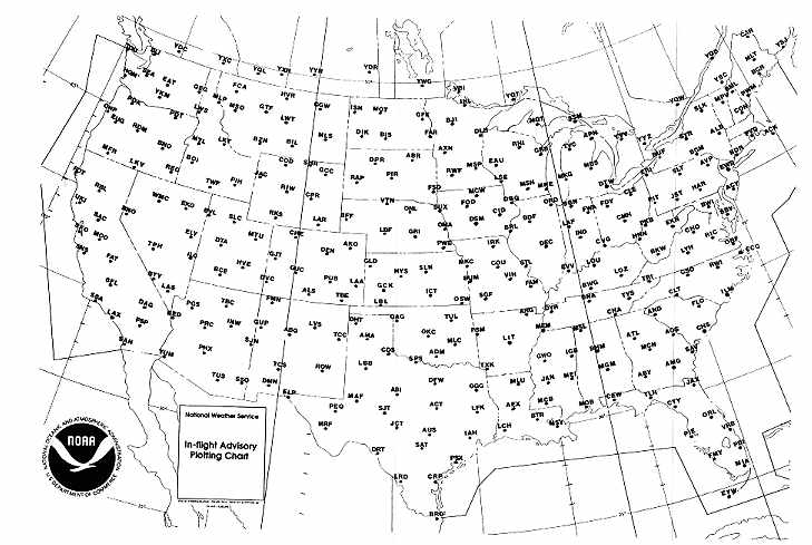
In-flight Aviation Weather Advisories are forecasts to advise en route aircraft of development of potentially hazardous weather. All In-flight Advisories in the conterminous U.S. are issued by the National Aviation Weather Advisory Unit (NAWAU) in Kansas City, MO. In Alaska, the three WSFOs (Anchorage, Fairbanks and Juneau) issue In-flight Advisories for their respective areas. The WSFO in Honolulu issues advisories for Hawaii. All heights are referenced to MSL, except in the case of ceilings (CIG) which indicates above ground level. The advisories are of three types - Convective SIGMET (WST), SIGMET (WS) and AIRMET (WA). All In-flight Advisories use the same location identifiers (either VORs, airports, or well-known geographic areas) to describe the hazardous weather areas (Figures 4-1 and 4-2).
CONVECTIVE SIGMET (WST)
Convective SIGMETs are issued in the conterminous U.S. for any of the following:
1. Severe thunderstorm due to:
a. surface winds greater than or equal to 50 knots
b. hail at the surface greater than or equal 3/4 inches in diameter
c. tornadoes.
2. Embedded thunderstorms.
3. A line of thunderstorms.
4. Thunderstorms greater than or equal to VIP level 4 affecting 40%
or more of an area at least 3000 square miles.
Any Convective SIGMET implies severe or greater turbulence, severe icing and low level wind shear. A Convective SIGMET may be issued for any convective situation which the forecaster feels is hazardous to all categories of aircraft.
Convective SIGMET bulletins are issued for the Eastern (E), Central (C) and Western (W) United States (Convective SIGMETs are not issued for Alaska or Hawaii). The areas are separated at 87 and 107 degrees west longitude with sufficient overlap to cover most cases when the phenomenon crosses the boundaries. Thus, a bulletin will usually be issued only for the area where the bulk of observations and forecast conditions are located. Bulletins are issued hourly at H+55. Special bulletins are issued at any time as required and updated at H+55. If no criteria meeting a Convective SIGMET are observed or forecast, the message "CONVECTIVE SIGMET ... NONE" will be issued for each area at H+55. Individual Convective SIGMETs for each area are numbered sequentially (01 - 99) each day, beginning at 00Z. A continuing Convective SIGMET phenomenon will be reissued every hour at H+55 with a new number. The text of the bulletin consists of either an observation and a forecast or just a forecast. The forecast is valid for up to 2 hours.
The following are examples of Convective SIGMET bulletins for the Central United States. For the Western United States, they would be numbered 20W and 21W. For the Eastern United States, they would be numbered 20E and 21E.
MKCC WST 221855
CONVECTIVE SIGMET 20C
VALID UNTIL 2055Z
ND SD
FROM 90W MOT-GFK-ABR-90 MOT
INTSFYG AREA SVR TSTMS MOVG FROM 2445. TOP ABV 450. WIND GUSTS TO 60 KTS RPRTD. TORNADOES...HAIL TO 2 IN ... WIND GUSTS TO 65 KTS PSBL ND PTN.
CONVECTIVE SIGMET 21C
VALID UNTIL 2055Z
50SE CDS
ISOLD SVR TSTM D30 MOVG FROM 2420. TOPS ABV 450. HAIL TO 2 IN ... WIND GUSTS TO 65 KTS PSBL.
OUTLOOK VALID 222055-230055
AREA 1 ... FROM INL-MSP-ABR-MOT-INL
SVR TSTMS CONT TO DVLP IN AREA OVR ND. AREA IS XPCD TO RMN SVR AND SPRD INTO MN AS STG PVA MOVS OVR VRY UNSTBL AMS CHARACTERIZED BY -12 LIFTED INDEX.
AREA 2 ... FROM CDS-DFW-LRD-ELP-CDS
ISOLD STG TSTMS WILL DVLP OVR SWRN AND WRN TX THRUT FCST PD AS UPR LVL TROF MOVS NEWD OVR VERY UNSTBL AMS. LIFTED INDEX RMS IN THE -8 TO -10 RANGE. DRY LINE WL BE THE FOCUS OF TSTM DVLPMT.
This is an example of a complete WST bulletin, including the Convective SIGMET Outlook. This is the 20th and 21st Convective SIGMETs of the day in the Central United States. The first message indicates an area of severe thunderstorms in North and South Dakota. These storms have produced wind gusts to 60 knots with the possibility of tornadoes, hail up to 2 inches, and 65 knot winds over North Dakota. The second message is about a single severe thunderstorm southeast of Childress. The outlook section focuses on the Dakotas in Area 1 and Texas in Area 2.
SIGMET (WS) / AIRMET (WA)
SIGMETs / AIRMETs are issued for the six areas corresponding to the FA areas (Figure 1-4). The maximum forecast period is four hours for SIGMETs and six hours for AIRMETs. Both advisories are considered "widespread" because they must be either affecting or be forecast to affect an area of at least 3,000 square miles at any one time. At times, the total area to be affected during the forecast period (see Fig. 4-1; In-flight Advisory Plotting Chart) is very large. It could be that only a small portion of this total area would be affected at any one time. An example would be a 3,000 square mile phenomenon forecast to move across an area totaling 25,000 square miles during a forecast period.
SIGMET (WS)
A SIGMET advises of non-convective weather that is potentially hazardous to all aircraft. In the conterminous U.S., SIGMETs are issued when the following phenomena occur or are expected to occur:
1. Severe icing not associated with thunderstorms
2. Severe or extreme turbulence or clear air turbulence (CAT) not associated
with thunderstorms
3. Duststorms, sandstorms, or volcanic ash lowering surface or in-flight
visibilities to below three miles
4. Volcanic eruption
SIGMETs are identified by an alphabetic designator which include NOVEMBER through YANKEE but exclude SIERRA and TANGO. The first issuance of a SIGMET will be labeled UWS (Urgent Weather Sigmet) and subsequent issuances at the forecasters discretion. Issuances for the same phenomenon will be sequentially numbered, using the original designator until the phenomenon ends. For example, the first issuance in the CHI area for phenomenon moving from the SLC area will be SIGMET PAPA 3, if the previous two issuances, PAPA 1 and PAPA 2 had been in the SLC area. Note that no two different phenomena across the country can have the same alphabetic designator at the same time.
For example,
DFWP UWS 051710
SIGMET PAPA 1 VALID UNTIL 052110 AR LA MS
FROM STL TO 30N MEI TO BTR TO MLU TO STL OCNL SVR ICING 90 TO 130 EXPCD.
FRZLVL 80 E TO 120 W. CONDS CONTG BYD 2100Z.
SFOR WS 100130
SIGMET ROMEO 2 VALID UNTIL 100530 OR WA
FROM SEA TO PDT TO EUG TO SEA
OCNL MOGR CAT BTN 280 AND 350 EXPCD DUE TO JTSTR. CONDS BGNG AFT 0200Z
CONTG BYD 0530Z AND SPRDG OVR CNTRL ID BY 0400Z.
The first example above is a SIGMET bulletin issued for the DFW area at 1710Z on the 5th and is valid until 2110Z (Note maximum forecast period for a Sigmet is 4 hours). The designator PAPA identifies the phenomenon, in this case, severe icing. This is the first issuance of the SIGMET as indicated by "UWS" and "PAPA 1". The affected states within the DFW area are Arkansas, Louisiana and Mississippi. Freezing level data and a notation that conditions are expected to continue beyond 4 hours are included. (See Table 4-9 for definitions of variability terms.)
Some NWS offices have been designated by the International Civil Aviation Organization (ICAO) as Meteorological Watch Offices (MWOs). These offices are responsible for issuing International SIGMETs for designated areas which include Alaska, Hawaii, portions of the Atlantic and Pacific Oceans, and the Gulf of Mexico. The offices which issue International SIGMETs are Anchorage, AK, Fairbanks, AK, Juneau, AK, Miami, FL; Honolulu, HI; Kansas City, MO; and Guam. The criteria for an International SIGMET are the same as for a domestic SIGMET with the following items added:
1. Thunderstorms occurring in lines or embedded in clouds or haze
2. Tropical cyclones
3. Marked mountain waves
4. Heavy hail
5. Severe squall line
Example of an International SIGMET:
WSAC1 PAFA 080255
PAZA SIGMET JULIETT 1 VALID 080300/080700 PAFA-MOD OR GREATER TURBC AND ASSOCIATED MTW EFFECT FCST BLW FL350 60 NM EITHER SIDE OF A LINE FM PAOR TO PAFA TO PAMC. NC.
This is SIGMET JULIET 1 issued by MWO Fairbanks, Alaska (PAFA) at 0255Z on the 8th. Is valid from 0300Z to 0700Z on the 8th and was issued for moderate or greater turbulence and associated mountain wave effect forecast below flight level 35,000 feet for an area 60 nautical miles either side of a line from Northway, Alaska (PAOR) to McGrath, Alaska (PAMC). No change (NC) is expected in the condition during the valid period.
AIRMET (WA)
AIRMETs (WA) are advisories of significant weather phenomena but describe conditions at intensities lower than those which trigger SIGMETs. AIRMETs are intended for dissemination to all pilots in the preflight and en route phase of flight to enhance safety. AIRMET Bulletins are issued on a scheduled basis every 6 hours. Unscheduled updates and corrections are issued as necessary. Each AIRMET Bulletin contains any current AIRMETs in effect, significant conditions not meeting AIRMET criteria, and an outlook for conditions expected after AIRMET valid period. The AIRMETs within each Bulletin are valid for 6 hours and contain details on one or more of the following phenomena when they occur or are forecast to occur:
1. Moderate icing
2. Moderate turbulence
3. Sustained surface winds of 30 knots or more
4. Ceiling less than 1,000 feet and/or visibility less than 3 miles
affecting over 50 percent of the area at one time
5. Extensive mountain obscurement
AIRMET Bulletins have fixed alphanumeric designators of SIERRA for Instrument Flight Rules (IFR) and mountain obscurations; TANGO for turbulence, strong surface winds, and low-level wind shear; and ZULU for icing and freezing level. In addition AIRMET SIERRA is referenced in the Area Forecast (FA). After the first issuance each day, scheduled or unscheduled Bulletins are numbered sequentially for easier identification. Example of an AIRMET Bulletin:
ZCZC MKCWA4T ALL 242000
WAUS1 KDFW 241650
DFWT WA 241650 AMD
AIRMET TANGO UPDT 3 FOR TURBC ... STG SFC WINDS AND LLWS VALID UNTIL
242000
AIRMET TURBC ... OK TX ... UPDT
FROM OSW TO LRD TO PEQ TO 40W LBL TO OSW
OCNL MDT TURBC BLO 60 DUE TO STG AND GUSTY LOW LVL WINDS. CONDS CONTG
BYD 2000Z.
AIRMET STG SFC WINDS ... TX
FROM CDS TO DFW TO SAT TO MAF TO CDS
AFT 18Z ... SUSTAINED SFC WINDS GTR THAN 30 KTS XPCD.
COND CONTG BYD 2000Z.
LLWS BLO 20 AGL DUE TO STG WINDS DMSHG BY 18Z.
OTLK VALID 2000-0200Z ... OK TX AR
MDT TURBC BLO 60 CONTG OVR OK/TX AND SPRDG INTO AR BY 2200-0200Z. CONTG
ENTR AREA BYD 0200Z.
NNNN
ALASKA AREA FORECASTS
The Area Forecasts issued by the NWS offices in Alaska follow a specialized format. The Alaska FA has a SYNOPSIS section similar to the FAs for the 48 contiguous states and Hawaii. Beyond this, the primary difference is that the forecasts and advisories for each individual geographic area are combined into a single product; i.e., each section includes all AIRMETs, SIGMETs, IFR/VFR/MVFR CLOUDS AND WEATHER, designated PASS forecasts where appropriate, ICING, TURBULENCE, STRONG SURFACE WINDS, or any other weather phenomena the forecaster deems important for aviation users for that particular area.
An example of portions of an Anchorage, Alaska, Area Forecast:
/D ANCH FA 211945
AK SRN HLF XCP SE AK...
SYNOPSIS VALID UNTIL 221400
RDG OF HI PRES FM OME TO UAK. OCFNT 120 NM N OF ADK TO DUT AND SEWD MOVG TO SNP TO PTH AND
SEWD BY 14Z.
AIRMETS VALID UNTIL 220200
TSTMS IMPLY SVR OR GTR TURBC SRV ICG LLWS AND IFR CONDS. NON MSL HGTS DENOTED BY AGL OR CIG.
COOK INLET AND SUSITNA VLY AB ... VALID UNTIL 220800 ... CLDS/WX...
25 SCT-BKN 65 BKN LYRS TO 90. SCT RW, LCL CIG AOB 10 AND VSBYS AOB 3RW-.
OTLK VALID 220800-230200... VFR.
PASSES ... LK CLARK-MERRILL AND RAINY... MVFR CIG. WINDY AND TAHNETA.. VFR. PORTAGE... IFR CIG F. ...TURBC...
NONE SGFNT.
... ICG AND FRZLVL...
NONE SGFNT. FRZLVL 070-080.
...///...
AK PEN ... VALID UNTIL 220800 ... CLDS/WX...
***AIRMET IFR***WDSPRD CIG BLO 10 AND VSBYS BLO 3R-F ALG PAC CST. CONTG BYD 02Z.. ***AIRMET STG SFC WNDS***LCL SFC WNDS SELY 50 KTS. WNDS DMSHG AFT 01Z...
CIG BLO 10 AND VSBY BLO 3R-F PRSTG PAC CST. LCL CIG BLO 10 AND VSBYS BLO 3R-F ON BERING CST. ELSW 15-25 OVC. VSBYS 3-5R-F. TOPS 180. SFC WNDS SE 25 KTS TIL 06Z. OTLK VALID 220800-230200 ... MVFR CIG RW. ...TURBC...
***SIGMET***MIKE 1 FOR TURBC VALID 211715/222115 PANC-SEV TURBC BLO 060 FCST 60 NM EITHER SIDE OF LINE FROM DUT TO CDB. NC. ... ICG AND FRZLVL..
***AIRMET ICG***OCNLY MDT ICGICIP 070-140. ENDG BY 00Z.. FRZLVL 070 LWRG TO 040 BY 06Z.
INTERNATIONAL AREA FORECASTS
Area Forecasts from the surface to 25,000 feet are also prepared in international format for areas in the Atlantic Ocean, Caribbean Sea, and the Gulf of Mexico. Moreover, significant weather forecasts for 25,000 feet to 60,000 feet are prepared in chart form and in international text format for the northern and western hemisphere.
Example of an International Area Forecast from the surface to FL250.
FANT2 KWBC 091600
091800Z TO 100600Z
ATLANTIC OCEAN WEST OF A LINE FROM 40N 67W TO 32N 63W. SFC TO FL250.
SYNOPSIS.
RIDGE OVER AREA MOVING TO EAST. FRONTAL SYSTEM MOVING OFF COAST BY 06Z.
SIGNIFICANT CLDS/WX
N OF 34N AND W OF 71W ... PATCHES OVC005/015 TOP 030/040 OTHERWISE BKN/OVC015/025 BKN/OVC200/240. BY 06Z INCREASING IMC IN SHRA/TS SPREADING ACROSS AREA FROM WEST. TS TOPS ABOVE 240.
S OF 34N AND W OF 75W ... SCT/BKN 015/250. BY 06Z INCREASING IMC IN SHRA/TS SPREADING ACROSS AREA FROM WEST. TS TOPS ABOVE 240.
ELSEWHERE ... CLR OCNL SCT015/025. BY 06Z INCREASING BKN080/100.
ICE.
FZ LVL 080/090 N SLOPING TO 120/130 S. MOD IN SHRA. SEV IN TS.
TURB.
MOD IN SHRA. SEV IN TS.
OUTLOOK.
100600Z TO 101800Z
FRONT CONTINUING SLOWLY EWD. INCREASING IMC IN SHRA/TS SPREADING E OVER AREA. SHRA/TS ENDING SW PORTION AFTER FRONTAL PASSAGE.
Example of weather forecast for FL250 to FL600
FAPA1 KWBC 141610
SIG WX PROG FL250-FL600 VALID 150600Z
ISOL EMBD CB TOPS 400 NE OF 11N173W 14N166W 11N164W 01N174W
ISOL EMBD CB TOPS 400 07N158W 08N137W 11N137W 12N158W 07N158W
ISOL EMBD CB TOPS 400 19N157W 29N140W 32N143W 22N162W 15N162W
MDT OR GRTR TURB AND ICG VCNTY ALL CBS
MDT TURB 310-410 19N145W 25N144W 19N163W 15N162W 19N145W
The wording of the International Area Forecasts closely follows domestic Area Forecasts, except international contractions are used which may differ slightly from domestic contractions. Some exceptions are:
SHRA - Rain showers
TS - Thunderstorm
SEV - Severe
ICE - Icing
IMC - Instrument Meteorological Conditions
The groups of numbers and letters arc the boundary points of the areas in latitude and longitude. For example "11N173W" is latitude 11 degrees north and longitude 173 degrees west.
TWEB ROUTE FORECASTS AND SYNOPSIS
The TWEB Route Forecast is similar to the Area Forecast except information is contained in a route format. Forecast sky cover (height and amount of cloud bases), cloud tops, visibility (including vertical visibility), weather, and obstructions to vision are described for a corridor 25 miles on either side of the route. Cloud bases and tops are always MSL unless noted. Ceilings are always above ground level (AGL).
A Synopsis, included with each grouping of Route Forecasts, is a brief statement of the weather systems affecting the route during the forecast valid period.
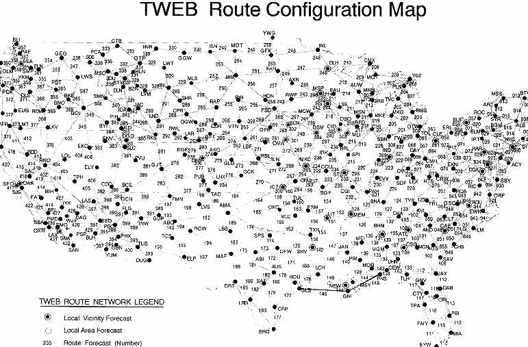
The TWEB Route Forecasts and Synopsis are prepared by WSFOs for more than 300 selected routes over the contiguous U.S. (Figure 1-6). These forecasts are used in the Transcribed Weather Broadcasts (TWEB), Telephone Information Briefing Service (TIBS), and Pilot's Automatic Telephone Weather Answering Service (PATWAS) transcriptions described in Section 1. Individual route forecasts and synopses are also available by request/reply service through any FSS or WSO.
The TWEB Route Forecasts and Synopses are issued by the WSFOs three times per day according to time zone (section 14 for issuance times). The TWEB forecast is valid for a 15-hour period. This schedule provides 24-hour coverage with most frequent updating during the hours of greatest general aviation activity.
BIS SYNS 250924. LO PRES TROF MVG ACRS ND TDA AND TNGT. HI PRES MVG SEWD FM CANADA INTO NWRN ND BY TNGT AND OVR MST OF ND BY WED MRNG.
BIS - Bismark, ND. WSFO issuing the Synopsis and Route Forecasts
SYNS - Synopsis for the area covered by the Route Forecasts
25 - 25th day of the month
0924 - Valid from 09Z on the 25th to 00Z on the 26th (15 hours).
(Rest of message)
Low pressure trough moving across North Dakota today and tonight. High pressure moving southeastward from Canada into northwestern North Dakota by tonight and over most of North Dakota by Wednesday morning.
An example of a TWEB Route Forecast:
249 TWEB 250924 GFK-MOT-ISN. ALL HGTS MSL XCP CIGS. GFK VCNTY CIGS AOA 5 THSD TILL 12Z OTRW OVER RTE CIGS 1 TO 3 THSD VSBY 3 TO 5 MI IN LGT SNW WITH CONDS BRFLY LWR IN HVYR SNW SHWRS.
249 - Route number
TWEB - TWEB Route Forecast
25 - 25th day of the month
0924 - Valid 09Z on the 25th to 00Z on the 26th
(15 hours)
GFK-MOT-ISN - Route: Grand Forks to Minot to
Williston, ND
(Rest of message)
All heights above mean sea level except ceilings - Grand Forks vicinity ... Ceilings at or above 5,000 feet until 1200Z. Otherwise over route ... ceilings 1,000 to 3,000 feet ... visibility 3 to 5 miles in light snow with conditions briefly lower in heavier snow showers.
When visibility is NOT stated, it is implied to be greater than 6 miles.
Because of their varied accessibility and route format, these forecasts are important and useful weather information that is available to the pilot for flight operations and planning.
WINDS AND TEMPERATURES ALOFT FORECAST (FD)
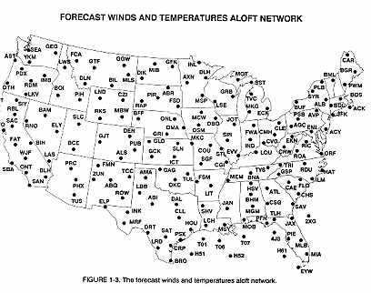
Winds and temperatures aloft are forecast for specific locations in the contiguous U.S., as shown in Figure 1-3. FD forecasts are also prepared for a network of locations in Alaska and Hawaii as shown in Figure 1-3A. Forecasts are made twice daily based on 00Z and 12Z data for use during specific time intervals.
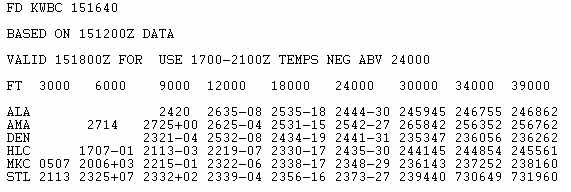
Below is a sample FD message containing a heading and six FD locations.
The heading always includes the time during which the FD may be used (1700-2100Z
in the example) and a notation "TEMPS NEG ABV 24000." Since temperatures
above 24,000 feet are always negative, the minus sign is omitted.
|
Forecast Levels
The line labelled "FT" shows 9 to 11 standard FD levels. The 45,000 foot and 53,000 foot levels are electronically transmitted and are available in the communications system. The pilot may request these levels from the FSS briefer or NWS meteorologist. Through 12,000 feet, the levels are true altitude, and above 18,000 feet, the levels are pressure altitude. The FD locations are transmitted in alphabetical order.
Note that some lower-level wind groups are omitted. No winds are forecast within 1,500 feet of station elevation. Also, no temperatures are forecast for the 3,000 foot level or for any level within 2,500 feet of station elevation.
A 4-digit group shows wind direction, in reference to true north, and wind speed. Look at the St. Louis (STL) forecast for 3,000 feet. The group 2113 means the wind is from 210 degrees at 13 knots. The first two digits give direction in tens of degrees and the second two digits are the wind speed in knots.
A 6-digit group includes forecast temperatures. In the STL forecast, the coded group for 9,000 feet is 2332+02. The wind is from 230 degrees at 32 knots and the temperature is plus 2 degrees Celsius. If a coded direction is more than "36," then the wind speed is 100 knots or more. Therefore, if the wind direction number is between 51 and 86, the wind speed will be over 100 knots. For example, the STL forecast for 39,000 feet is "731960." The wind direction is from 230 degrees (73-50=23) and the speed is 119 knots (100+19= 119). The temperature is minus 60 degrees Celsius.
If the wind speed is forecast to be 200 knots or greater, the wind group is coded as 199 knots. For example, "7799" is decoded as 270 degrees at 199 knots or greater.
When the forecast speed is less than 5 knots, the coded group is "9900" and read, "LIGHT AND VARIABLE."
Examples of decoding FD winds and temperatures:
Coded Decoded
9900+00 Wind light and variable, temperature 0 degrees Celsius
2707 270 degrees at 7 knots
850552 350 degrees (85-50=35) at 105 knots (100+05=105), temperature
-52 degrees Celsius
SPECIAL FLIGHT FORECAST
When planning a special category flight and scheduled forecasts are insufficient to meet the need. The pilot may request a special flight forecast through any FSS or WSO. Special category flights are hospital or rescue flights; experimental, photographic, or test flights; records attempts; and mass flights (such as air tours, air races and fly-aways, from special events).
Pilots should make requests far enough in advance to allow ample time for preparing and transmitting the forecast. Advance notice of 6 hours is desirable. In making a request, the pilot should give the:
1. Aircraft mission
2. Number and type of aircraft
3. Point of departure
4. Route of flight (including intermediate stops, destination, alternates)
5. Estimated time of departure
6. Time en route
7. Flight restrictions (such as VFR, below certain altitudes, etc.)
8. Time forecast is needed
The forecast is written in plain language contractions as in the example:
SPL FLT FCST ABQ-PHOTO MISSION-ABQ 121500Z. THIN CI CLDS AVGG LESS THAN TWO TENTHS CVR. VSBY MORE THAN 30. WNDS AND TEMPS ALF AT FLT ALTITUDE 2320+03. ABQ WSFO 052300Z.
CENTER WEATHER SERVICE UNIT (CWSU) PRODUCTS
Center Weather Service Unit products are issued by the CWSU meteorologist located in the ARTCCs. Coordination between the CWSU meteorologist and the nearby NWS WSFO is extremely important because both can address the same event. If time permits, coordination should take place before the CWSU meteorologist issues a product.
METEOROLOGICAL IMPACT STATEMENT (MIS)
A Meteorological Impact Statement (MIS) is an unscheduled traffic/flight operations planning forecast of conditions expected to begin beyond 2 hours but within 12 hours after issuance. This enables the impact of expected weather conditions to be included in air traffic control decisions in the near future.
A MIS will be issued when the following three conditions are met:
1. If any one of the following conditions are forecast:
a. convective SIGMET criteria
b. moderate or greater icing and/or turbulence
c. heavy or freezing precipitation
d. low IFR conditions
e. surface winds/gusts 30 knots or greater
f. low-level wind shear within 2,000 feet of the surface
g. volcanic ash, dust or sandstorm
2. If the impact occurs on air traffic flow within the ARTCC area of
responsibility.
3. If the forecast lead time (the time between issuance and outset
of a phenomenon), in the forecaster's judgment, is sufficient to make issuance
of a Center Weather Advisory (CWA) unnecessary.
An example of a MIS:
ZMP MIS 01 VALID 041200-050100
ISOLD LVL 2-4 TSTMS TOPS 350-450 MOVG FM 2925 OVR NW ND. TSTMS MOVG INTO E ND SD W MN AFT 18Z AND RMG IN CLSTRS AFT 22Z TOPS 400-500.
This MIS from the Minneapolis, MN, ARTCC is the first issuance of the day. It was issued at 1200Z on the 4th and is valid until 0100Z on the 5th.
CENTER WEATHER ADVISORY (CWA)
A Center Weather Advisory (CWA) is an unscheduled in-flight air crew, flow control, air traffic advisory for use in anticipating and avoiding adverse weather conditions in the en route and terminal areas. The CWA is not a flight planning forecast but a nowcast for conditions beginning within the next two hours. Maximum valid time of a CWA is two hours, no more than two hours between issuance time and "valid until time." If conditions are expected to continue beyond the valid period, a statement will be included in the Advisory.
A CWA may be issued for the following three situations:
1. As a supplement to an existing Inflight Advisory or Area Forecast (FA) section for the purpose of improving or updating the definition of the phenomenon in terms of location, movement, extent, or intensity relevant to the ARTCC area of responsibility. This is important for the following reason. A SIGMET for severe turbulence was issued by the NAWAU unit and the outline covered the entire ARTCC area for the total four-hour valid time period. However, the Advisory may only cover a relatively small portion of the ARTCC area at any one time during the four-hour period.
2. When an Inflight Advisory has not yet been issued but conditions meet Inflight Advisory criteria based on current pilot reports and the information must be disseminated sooner than the NAWAU unit can issue the Inflight Advisory. In this case of an impending SIGMET, the CWA will be issued as an urgent "UCWA" to allow the fastest possible dissemination.
3. When Inflight Advisory criteria is not met but conditions are or will shortly be adversely affecting the safe flow of air traffic within the ARTCC area of responsibility.
An example of a CWA:
ZKC3 CWA 032140
ZKC CWA 301 VALID UNTIL 032340
ISOLD SVR TSTM OVR COU MOVG SWWD 10 KTS. TOP 610. WND GSTS TO 55 KTS. HAIL TO 1 INCH RPRTD AT COU. SVR TSTM CONTG BYD 2340.
This is a CWA issued from the Kansas City, MO, ARTCC. The "3" after the ZKC in the first line denotes this CWA has been issued for the third weather phenomena to occur for the day. The "301" in the second line denotes the phenomena number again (3) and the issuance number (01) for this phenomena. The CWA was issued at 2140Z and is valid until 2340Z.
HURRICANE ADVISORY (WH)
When a hurricane threatens a coast line, but is located at least 300 nm offshore, an abbreviated Hurricane Advisory (WH) is issued to alert aviation interests. The Advisory gives location of the storm center, its expected movement, and the maximum winds in and near the storm center. It does not contain details of associated weather, as specific ceilings, visibilities, weather, and hazards that are found in the Area Forecasts, Terminal Forecasts, and Inflight Advisories.
An example of an abbreviated Aviation Hurricane Advisory:
MIA WH 181010
HURCN BOB AT 1000Z CNTRD 29.4N 74.2W OR 400 NMI E OF JACKSONVILLE FL EXPCTED TO MOV N ABT 12 KT. MAX WNDS 110 KT OVR SML AREA NEAR CNTR AND HURCN WNDS WITHIN 55-75 NMI.
CONVECTIVE OUTLOOK (AC)
A Convective Outlook (AC) describes the prospects for general thunderstorm activity during the following 24 hours. Areas in which there is a high, moderate, or slight risk of severe thunderstorms are included as well as areas where thunderstorms may approach severe limits (approaching is defined as winds greater than or equal to 35 knots but less than 50 knots and/or hail equal to or greater than 1/2 inch in diameter). Refer to the "Severe Weather Outlook Chart" (Section 11) for "risk" definitions. Forecast reasoning is also included in all ACs.
Outlooks are transmitted by the National Severe Storm Forecast Center (NSSFC) in Kansas City, MO, at 0700Z and 1500Z. Forecasts in each AC are valid until 1200Z the next day and are used to prepare and update the Severe Weather Outlook Chart. Use the Outlook primarily for planning flights later in the day.
Severe thunderstorm criteria:
1. Winds equal to or greater than 50 knots at the surface or,
2. Hail equal to or greater than 3/4 inch diameter at the surface or,
3. Tornadoes
An example of a Convective Outlook:
MKC AC 280700
CONVECTIVE OUTLOOK ... REF AFOS NMCGPH940
VALID 281200 - 291200Z
THERE IS A MDT RISK OF SVR TSTMS OVER PTNS ERN AL..MUCH OF GA..SC..NC..THE SE HALF OF VA..AND EXTRM SRN MD..TO RGT OF LN FM SAV MGR CEW SEM RMG HSS ROA CHO WAL.
THERE IS A SLGT RISK OF SVR TSTMS TO RGT OF LN FM MOB JAN MEM BNA LOZ IAD ACY..CONT..WAL CHO ROA HSS RMG SEM CEW MGR SAV..CONT VRB FMY.
GEN TSTMS ARE FCST TO RGT OF LN FM BLI YKM 4BW WMC TVL SFO..CONT..LCH SHV HOT PAH JST NEL.
STG SFC LO OVR WRN IN EXPCD TO MOV ENE AND DPN DURG NEXT 24 HRS. STLT INDCS UPR LVL IMPULSE FM WRN TN INTO SW AL ROTATING ARND TROF ABT 45 KTS. STG TSTMS CURRENTLY MOVG ACRS AL AHD OF UPR VORT MAX EXPCD TO CONT MOVG E. AMS OVR SE U.S. RMNS MOIST AND UNSTBL BNTH FVRBL UPR LVL DIFLUENCE. SGFNT SVR TSTMS EXPCD FM GA NE INTO SE VA WHERE LO LVL WRM ADVCTN AND CNVRGNC WL BE CONCENTRATED.
ISOLD TSTMS EXPCD TO DVLP PTNS N PAC CST SPRDG INLAND AFT 00Z AS CD AIR ALF ASSOCD WITH NEXT UPR SYS APCHS WRN U.S.
... KLOTH...
SEVERE WEATHER WATCH BULLETINS (WW) and ALERT MESSAGES (AWW)
A severe weather watch bulletin (WW) defines areas of possible severe thunderstorms or tornado activity. The bulletins are issued by the National Severe Storm Forecast Center at Kansas City, MO. WWs are unscheduled and are issued as required.
A Severe Thunderstorm Watch describes areas of expected severe thunderstorms. A Tornado Watch describes areas where the threat of tornadoes exists. In order to alert the WSFOs, WSOs, CWSUs, FSSs and other users, a preliminary message called the Alert Severe Weather Watch message (AWW) is sent before the main bulletin.
An example of a preliminary message:
MKC AWW 281909
WW 56 TORNADO GA SC NC VA AND ADJ CSTL WTRS 282000Z - 290300Z
AXIS..70 STATUTE MILES EITHER SIDE OF LINE..30 W AGS/AUGUSTA GA/ TO 30 NE ECG/ELIZABETH CITY NC/
HAIL SURFACE AND ALOFT..3 INCHES. WIND GUSTS..70 KNOTS. MAX TOPS TO 500. MEAN WIND VECTOR 250/60.
Soon after the preliminary message goes out, the actual Watch bulletin itself is issued. A Severe Weather Watch is in the following format:
1. Type of severe weather watch, watch area, valid time period, type
of severe weather possible, watch axis, meaning of a watch, and a statement
that persons should be on the lookout for severe weather.
2. Other watch information, i.e. references to previous watches.
3. Phenomena, intensities, hail size, wind speed (knots), maximum CB
tops and estimated cell movement (mean wind vector).
4. Cause of severe weather.
5. Information on updating ACs.
An example of a Watch bulletin:
MKC WW 281914
BULLETIN - IMMEDIATE BROADCAST REQUESTED TORNADO WATCH NUMBER 56
NATIONAL WEATHER SERVICE KANSAS CITY MO 214 PM EST WED MAR 28 1984
A..THE NATIONAL SEVERE STORMS FORECAST CENTER HAS ISSUED A TORNADO WATCH
FOR
MOST OF SOUTH CAROLINA MOST OF CENTRAL AND EASTERN NORTH CAROLINA PARTS
OF SOUTHEAST VIRGINIA PARIS OF EASTERN GEORGIA ADJOINING COASTAL WATERS
FROM 3 PM EST UNTIL 10 PM EST TODAY.
B..TORNADOES..LARGE HAIL..DANGEROUS LIGHTNING AND DAMAGING THUNDERSTORM WINDS ARE POSSIBLE IN THESE AREAS. THE TORNADO WATCH AREA IS ALONG AND 70 STATUTE MILES EITHER SIDE OF A LINE FROM 30 MILES WEST OF AUGUSTA GEORGIA TO 30 MILES NORTHEAST OF ELIZABETH NORTH CAROLINA. REMEMBER..A TORNADO WATCH MEANS CONDITIONS ARE FAVORABLE FOR TORNADOES AND SEVERE THUNDERSTORMS IN AND CLOSE TO THE WATCH AREA. PEOPLE IN THESE AREAS SHOULD BE ON THE LOOKOUT FOR THREATENING WEATHER CONDITIONS AND LISTEN FOR LATER STATEMENTS AND POSSIBLE WARNINGS.
C..TORNADOES AND A FEW SVR TSTMS WITH HAIL SFC AND ALF TO 3 IN. EXTRM TURBC AND SFC WND GUSTS TO 70 KT. A FEW CBS WITH MAX TOPS TO 500. MEAN WIND VECTOR 250/60.
D..PARAMETERS IN CAROLINAS VERY STG WITH STG LOW LVL FLOW AND CNVRGNC ALG WITH UNSTABLE AMS. MESO LOW MVG RPDLY THRU ERN AL WILL CONT ENE INTO CAROLINAS THIS EVENG. MEANWHILE SVR TSTMS LIKELY DVLPG IN ADVANCE THIS AFTN DUE TO ABV MENTIONED CONDS.
Status reports are issued as needed to show progress of storms and to delineate areas no longer under the threat of severe storm activity. Cancellation bulletins are issued when it become evident that no severe weather will develop or that storms have subsided and are no longer severe.
When tornadoes or severe thunderstorms have developed, WSOs, WSFOs,
and WFOs issue local warnings.