|
|
| INSTRUMENT PROCEDURES HANDBOOK |
|
RELEASE TIME ATC uses an IFR release time2 in conjunction with traffic management procedures to separate departing aircraft from other traffic. For example, when controlling departures from an airport without a tower, the controller limits the departure release to one aircraft at any given time. Once that aircraft is airborne and radar identified, then the following aircraft may be released for departure, provided they meet the approved radar separation (3 miles laterally or 1,000 feet vertically) when the second aircraft comes airborne. Controllers must take aircraft performances into account when releasing successive departures, so that a B-747 HEAVY aircraft is not released immediately after a departing Cessna 172. Besides releasing fast aircraft before slow ones, another technique commonly used for successive departures is to have the first aircraft turn 30 to 40 degrees from runway heading after departure, and then have the second aircraft depart on a SID or runway heading. Use of these techniques is common practice when maximizing airport traffic capacity. EXPECT DEPARTURE CLEARANCE TIME Another tool that the FAA is implementing to increase efficiency is the reduction of the standard expect departure clearance time3 (EDCT) requirement. The FAA has drafted changes to augment and modify procedures contained in Ground Delay Programs (GDPs). Airlines may now update their departure times by arranging their flights’ priorities to meet the controlled time of arrival. In order to evaluate the effectiveness of the new software and the airline-supplied data, the actual departure time parameter in relation to the EDCT has been reduced. This change impacts all flights (commercial and GA) operating to the nation’s busiest airports. Instead of the previous 25-minute EDCT window (5 minutes prior and 20 minutes after the EDCT), the new requirement for GDP implementation is a 10-minute window, and aircraft are required to depart within 5 minutes before or after their assigned EDCT. Using reduced EDCT and other measures included in GDPs, ATC aims at reducing the number of arrival slots issued to accommodate degraded arrival capacity at an airport affected by weather. The creation of departure or ground delays is less costly and safer than airborne holding delays in the airspace at the arrival airport. MANAGING SAFETY AND CAPACITY SYSTEM DESIGN The CAASD is aiding in the evolution towards free flight with its work in developing new procedures necessary for changing traffic patterns and aircraft with enhanced capabilities, and also in identifying traffic flow constraints that can be eliminated. This work supports the FAA’s Operational Evolution Plan in the near-term. Rapid changes in technology in the area of navigation performance, including the change from ground-based area navigation systems, provide the foundation for aviation’s global evolution. This progress will be marked by combining all elements of communication, navigation, and surveillance (CNS) with air traffic management (ATM) into tomorrow’s CNS/ATM based systems. The future CNS/ATM operating environment will be based on navigation defined by geographic waypoints expressed in latitude and longitude since instrument procedures and flight routes will not require aircraft to overfly ground-based navigation aids defining specific points. APPLICATION OF AREA NAVIGATION RNAV airways provide more direct routings than the current VOR-based airway system, giving pilots easier access through terminal areas, while avoiding the circuitous routings now common in many busy Class B areas. RNAV airways are a critical component to the transition from ground-based navigation systems to GPS navigation. RNAV routes help maintain the aircraft flow through busy terminals by segregating arrival or departure traffic away from possibly interfering traffic flows. Further, RNAV provides the potential for increasing airspace capacity both en route and in the terminal area in several important ways. Strategic use of RNAV airways nationwide is reducing the cost of flying and providing aircraft owners more benefits from their IFR-certified GPS receivers. Several scenarios have been identified where RNAV routes provide a substantial benefit to users.
Dozens of new RNAV routes have been designated, and new ones are being added continuously. In order to designate RNAV airways, the FAA developed criteria, en route procedures, procedures for airway flight checks, and created new charting specifications. Some of the considerations include:
In the future, as aircraft achieve higher levels of navigation accuracy and integrity, closely spaced parallel routes may be introduced, effectively multiplying the number of available routes between terminal areas. RNAV can be used in all phases of flight and, when implemented correctly, results in:
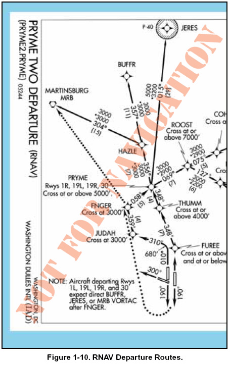
For example, take the situation at Philadelphia International Airport, located in the middle of some highly popular north-south traffic lanes carrying New York and Boston traffic to or from Washington, Atlanta, and Miami. Philadelphia’s position is right underneath these flows. Chokepoints resulted from traffic departing Philadelphia, needing to wait for a “hole” in the traffic above into which they could merge. The CAASD helped US Airways and Philadelphia airport officials establish a set of RNAV departure routes that do not interfere with the prevailing established traffic. Traffic heading north or south can join the established flows at a point further ahead when higher altitudes and speeds have been attained. Aircraft properly equipped to execute RNAV procedural routes can exit the terminal area faster — a powerful inducement for aircraft operators to upgrade their navigation equipment. Another example of an RNAV departure is the PRYME TWO DEPARTURE from Washington Dulles International. Notice in Figure 1-10 the RNAV waypoints not associated with VORs help free up the flow of IFR traffic out of the airport by not funneling them to one point through a common NAVAID.
|