|
|
| INSTRUMENT PROCEDURES HANDBOOK |
|
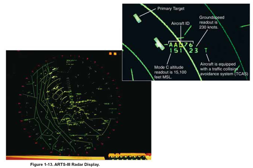
GPS-BASED HELICOPTER OPERATIONS The synergy between industry and the FAA created during the development of the Gulf of Mexico GPS grid system and approaches is an excellent example of what can be accomplished to establish the future of helicopter IFR SATNAV. The Helicopter Safety Advisory Council (HSAC), National Air Traffic Controllers Association (NATCA), helicopter operators, and FAA Flight Standards Divisions all worked together to develop this infrastructure. The system provides both the operational and cost-saving features of flying direct to a destination when offshore weather conditions deteriorate below VFR and an instant and accurate aircraft location capability that is invaluable for rescue operations. The expansion of helicopter IFR service for emergency medical services (EMS) is another success story. The FAA worked with EMS operators to develop helicopter GPS nonprecision instrument approach procedures and en route criteria. As a result of this collaborative effort, EMS operators have been provided with hundreds of EMS helicopter procedures to medical facilities. Before the GPS IFR network, EMS helicopter pilots had been compelled to miss 30 percent of their missions due to weather. With the new procedures, only about 11 percent of missions are missed due to weather. The success of these operations can be attributed in large part to the collaborative efforts between the helicopter industry and the FAA. There are currently 289 special use helicopter procedures, with more being added. There are also 37 public use helicopter approaches. Of these, 18 are to runways and 19 are to heliports or points-inspace (PinS). REDUCED VERTICAL SEPARATION MINIMUMS The U.S. domestic reduced vertical separation minimums (DRVSM) program has reduced the vertical separation from the traditional 2,000-foot minimum to a 1,000-foot minimum above FL 290, which allows aircraft to fly a more optimal profile, thereby saving fuel while increasing airspace capacity. The FAA has implemented DRVSM between FL 290 and FL 410 (inclusive) in the airspace of the contiguous 48 states, Alaska, and in Gulf of Mexico airspace where the FAA provides air traffic services. DRVSM is expected to result in fuel savings for the airlines of as much as $5 billion by 2016. Full DRVSM adds six additional usable altitudes above FL 290 to those available using the former vertical separation minimums. DRVSM users experience increased benefits nationwide, similar to those already achieved in oceanic areas where RVSM is operational. In domestic airspace, however, operational differences create unique challenges. Domestic U.S. airspace contains a wider variety of aircraft types, higher-density traffic, and an increased percentage of climbing and descending traffic. This, in conjunction with an intricate route structure with numerous major crossing points, creates a more demanding environment for the implementation of DRVSM than that experienced in applying RVSM on international oceanic routes. As more flights increase demands on our finite domestic airspace, DRVSM helps to reduce fuel burn and departure delays and increases flight level availability, airspace capacity, and controller flexibility. FAA RADAR SYSTEMS The FAA operates two basic radar systems; airport surveillance radar (ASR) and air route surveillance radar (ARSR). Both of these surveillance systems use primary and secondary radar returns, as well as sophisticated computers and software programs designed to give the controller additional information, such as aircraft speed and altitude. AIRPORT SURVEILLANCE RADAR The direction and coordination of IFR traffic within specific terminal areas is delegated to airport surveillance radar (ASR) facilities. Approach and departure control manage traffic at airports with ASR. This radar system is designed to provide relatively short-range coverage in the airport vicinity and to serve as an expeditious means of handling terminal area traffic. The ASR also can be used as an instrument approach aid. Terminal radar approach control facilities (TRACONs) provide radar and nonradar services at major airports. The primary responsibility of each TRACON is to ensure safe separation of aircraft transitioning from departure to cruise flight or from cruise to a landing approach. Most ASR facilities throughout the country use a form of automated radar terminal system (ARTS). This system has several different configurations that depend on the computer equipment and software programs used. Usually the busiest terminals in the country have the most sophisticated computers and programs. The type of 1-17 system installed is designated by a suffix of numbers and letters. For example, an ARTS-IIIA installation can detect, track, and predict primary, as well as secondary, radar returns. [Figure 1-13]
On a controller’s radar screen, ARTS equipment automatically provides a continuous display of an aircraft’s position, altitude, groundspeed, and other pertinent information. This information is updated continuously as the aircraft progresses through the terminal area. To gain maximum benefit from the system, each aircraft in the area must be equipped with a Mode C altitude encoding transponder, although this is not an operational requirement. Direct altitude readouts eliminate the need for time consuming verbal communication between controllers and pilots to verify altitude. This helps to increase the number of aircraft that may be handled by one controller at a given time. The FAA has begun replacing the ARTS systems with newer equipment in some areas. The new system is called STARS, for Standard Terminal Automation Replacement System. STARS is discussed in more detail later in this chapter. |