|
|
| INSTRUMENT PROCEDURES HANDBOOK |
|
AVIONICS AND INSTRUMENTATION The proliferation of advanced avionics and instrumentation has substantially increased the capabilities of aircraft in the IFR environment. FLIGHT MANAGEMENT SYSTEM
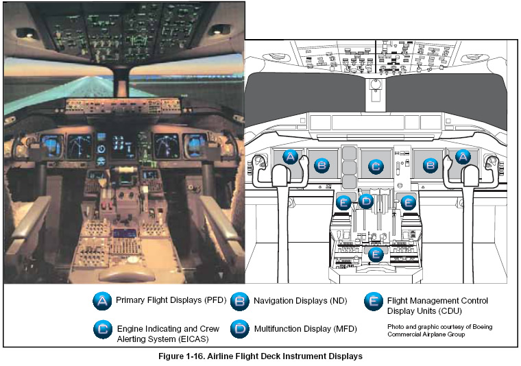
ELECTRONIC FLIGHT INFORMATION SYSTEM The electronic flight information system (EFIS) found in advanced aircraft cockpits offer pilots a tremendous amount of information on a colorful, easy-to-read display. Glass cockpits are a vast improvement over the earlier generation of instrumentation. [Figure 1-16] Primary flight, navigation, and engine information are presented on large display screens in front of the flight crew. Flight management CDUs are located on the center console. They provide data display and entry capabilities for flight management functions. The display units generate less heat, save space, weigh less, and require less power than traditional navigation systems. From a pilot’s point of view, the information display system is not only more reliable than previous systems, but also uses advanced liquid-crystal technology that allows displayed information to remain clearly visible in all conditions, including direct sunlight.
NAVIGATION SYSTEMS Navigation systems are the basis for pilots to get from one place to another and know where they are and what course to follow. Since the 1930s, aircraft have navigated by means of a set of ground-based NAVAIDs. Today, pilots have access to over 2,000 such NAVAIDs within the continental U.S., but the system has its limitations:
Since the 1980s, aircraft systems have evolved towards the use of SATNAV. Based on the GPS satellite constellation, SATNAV may provide better position information than a ground-based navigation system. GPS is universal so there are no areas without satellite signals. Moreover, a space-based system allows “off airway” navigation so that the efficiencies in aircraft route determination can be exacted. SATNAV is revolutionizing navigation for airlines and other aircraft owners and operators. A drawback of the satellite system, though, is the integrity and availability of the signal, especially during electromagnetic and other events that distort the Earth’s atmosphere. In addition, the signal from space needs to be augmented, especially in traffic-dense terminal areas, to guarantee the necessary levels of accuracy and availability. The CAASD is helping the navigation system of the U.S. to evolve toward a satellite-based system. The CAASD analysts are providing the modeling necessary to understand the effects of atmospheric phenomena on the GPS signal from space, while the CAASD is providing the architecture of the future navigation system and writing the requirements (and computer algorithms) to ensure the navigation system’s integrity. Moving toward a satellite-based navigation system allows aircraft to divorce themselves from the constraints of ground-based NAVAIDs and formulate and fly those routes that aircraft route planners deem most in line with their own cost objectives. With the advent of SATNAV, there are a number of applications that can be piggybacked to increase capacity in the NAS. Enhanced navigation systems will be capable of “random navigation,” that is, capable of treating any latitude-longitude point as a radio navigation fix, and being able to fly toward it with the accuracy we see today, or better. New routes into and out of the terminal areas are being implemented that are navigable by on-board systems. Properly equipped aircraft are being segregated from other aircraft streams with the potential to increase volume at the nation’s busy airports by keeping the arrival and departure queues full and fully operating. The CAASD is working with the FAA to define the nation’s future navigation system architecture. By itself, the GPS satellite constellation is inadequate to serve all the system’s needs. Augmentation of the GPS signal via WAAS and LAAS is a necessary part of that new architecture. The CAASD is developing the requirements based on the results of sophisticated models to ensure the system’s integrity, security, and availability. |
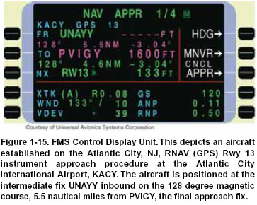 A flight management system (FMS) is a flight computer
system that uses a large database to allow routes to be
preprogrammed and fed into the system by means of a
data loader. The system is constantly updated with
respect to position accuracy by reference to conventional
navigation aids, inertial reference system technology, or
the satellite global positioning system. The sophisticated
program and its associated database ensures that the
most appropriate navigation aids or inputs are automatically
selected during the information update cycle. A
typical FMS provides information for continuous automatic
navigation, guidance, and aircraft performance
management, and includes a control display unit
(CDU). [Figure 1-15]
A flight management system (FMS) is a flight computer
system that uses a large database to allow routes to be
preprogrammed and fed into the system by means of a
data loader. The system is constantly updated with
respect to position accuracy by reference to conventional
navigation aids, inertial reference system technology, or
the satellite global positioning system. The sophisticated
program and its associated database ensures that the
most appropriate navigation aids or inputs are automatically
selected during the information update cycle. A
typical FMS provides information for continuous automatic
navigation, guidance, and aircraft performance
management, and includes a control display unit
(CDU). [Figure 1-15]