|
AERONAUTICAL CHARTS
Pilots can obtain most aeronautical charts and publications
produced by the FAA National Aeronautical
Charting Office (NACO). They are available by subscription
or one-time sales through a network of FAA
chart agents primarily located at or near major civil airports.
Additionally, opportunities to purchase or download
aeronautical publications online are expanding,
which provides pilots quicker and more convenient
access to the latest information. Civil aeronautical charts
for the U.S. and its territories, and possessions are produced
according to a 56-day IFR chart cycle by NACO,
which is part of the FAA’s Technical Ops Aviation
Systems Standards (AJW-3). Comparable IFR charts
and publications are available from commercial sources,
including charted visual flight procedures, airport qualification
charts, etc.
Most charts and publications described in this chapter
can be obtained by subscription or one-time sales from
NACO. Charts and publications are also available
through a network of FAA chart agents primarily
located at or near major civil airports. To order online,
use the “Catalogs/Ordering Info” link at http://www.naco.faa.gov. Below is the contact information
for NACO.
FAA, National Aeronautical Charting Office
Distribution Division AJW-3550
10201 Good Luck Road
Glenn Dale,
MD 20769-9700
Telephone
(301) 436-8301
(800) 638-8972
toll free, U.S. only
FAX (301) 436-6829
Email: 9-AMC-chartsales@faa.gov
IFR charts are revised more frequently than VFR charts
because chart currency is critical for safe operations.
Selected NACO IFR charts and products available
include IFR navigation charts, planning charts, supplementary
charts and publications, and digital products.
IFR navigation charts include the following:
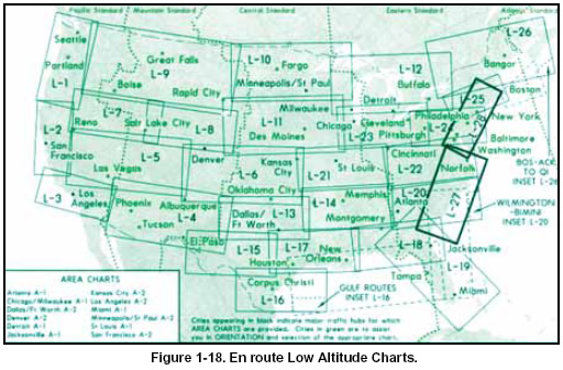
IFR En route Low Altitude Charts (Conterminous U.S. and Alaska):
En route low
altitude charts provide aeronautical information
for navigation under IFR conditions below 18,000
feet MSL. This four-color chart series includes airways;
limits of controlled airspace; VHF
NAVAIDs with frequency, identification, channel,
geographic coordinates; airports with terminal
air/ground communications; minimum en route
and obstruction clearance altitudes; airway distances;
reporting points; special use airspace; and
military training routes. Scales vary from 1 inch = 5
NM to 1 inch = 20 NM. The size is 50 x 20 inches
folded to 5 x 10 inches. The charts are revised every
56 days. Area charts show congested terminal areas
at a large scale. They are included with subscriptions
to any conterminous U.S. Set Low (Full set, East or
West sets). [Figure 1-18]
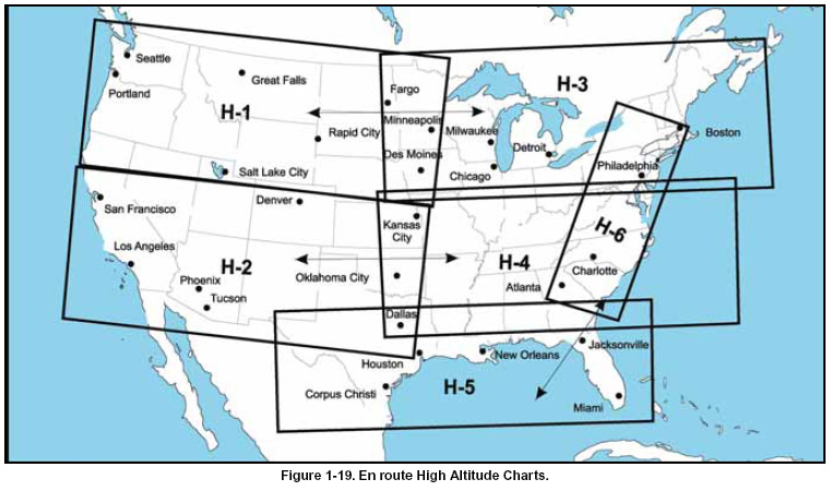
- IFR En route High Altitude Charts
(Conterminous U.S. and Alaska):
En route high
altitude charts are designed for navigation at or
above 18,000 feet MSL. This four-color chart
series includes the jet route structure; VHF
NAVAIDs with frequency, identification, channel,
geographic coordinates; selected airports; and
reporting points. The chart scales vary from 1 inch
= 45 NM to 1 inch = 18 NM. The size is 55 x 20
inches folded to 5 x 10 inches. Revised every 56
days. [Figure 1-19 ]
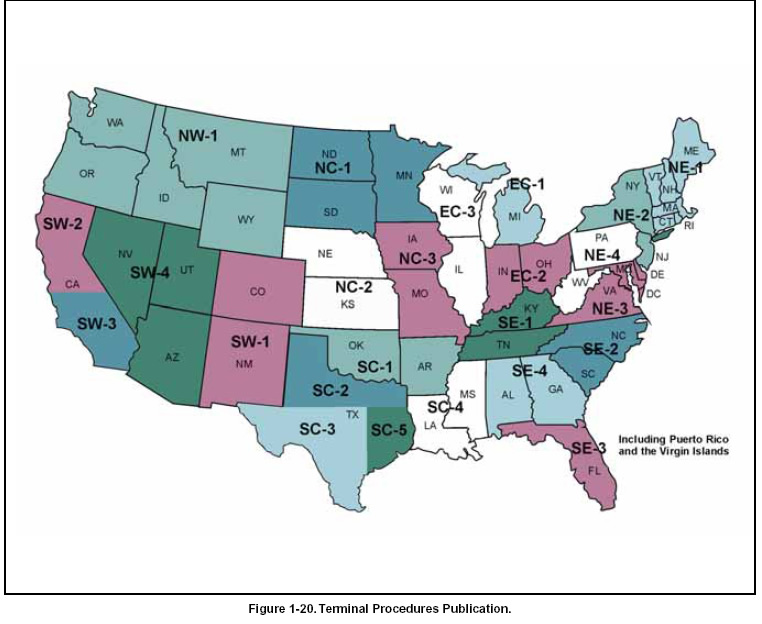
- U.S. Terminal Procedures Publication (TPP)
TPPs are published in 20 loose-leaf or perfect
bound volumes covering the conterminous U.S.,
Puerto Rico, and the Virgin Islands. A Change
Notice is published at the midpoint between revisions
in bound volume format. [Figure 1-20]
- Instrument Approach Procedure (IAP) Charts: IAP charts portray the aeronautical data that is
required to execute instrument approaches to airports.
Each chart depicts the IAP, all related navigation
data, communications information, and
an airport sketch. Each procedure is designated
for use with a specific electronic navigational
aid, such as an ILS, VOR, NDB, RNAV, etc.
- Instrument Departure Procedure (DP) Charts: There are two types of departure procedures;
Standard Instrument Departures (SIDs) and
Obstacle Departure Procedures (ODPs). SIDs
will always be in a graphic format and are
designed to assist ATC by expediting clearance
delivery and to facilitate transition between takeoff and en route operations. ODPs are
established to ensure proper obstacle clearance
and are either textual or graphic, depending on
complexity.
- Standard Terminal Arrival (STAR) Charts: STAR charts are designed to expedite ATC
arrival procedures and to facilitate transition
between en route and instrument approach
operations. They depict preplanned IFR ATC
arrival procedures in graphic and textual form.
Each STAR procedure is presented as a separate
chart and may serve either a single airport
or more than one airport in a given geographic
area.
- Airport Diagrams: Full page airport diagrams
are designed to assist in the movement of
ground traffic at locations with complex runway
and taxiway configurations and provide
information for updating geodetic position navigational
systems aboard aircraft.
- Alaska Terminal Procedures Publication:
This publication contains all terminal flight procedures
for civil and military aviation in Alaska. Included are
IAP charts, DP charts, STAR charts, airport diagrams,
radar minimums, and supplementary support
data such as IFR alternate minimums, take-off minimums,
rate of descent tables, rate of climb tables,
and inoperative components tables. The volume is
5-3/8 x 8-1/4 inches top bound, and is revised every
56 days with provisions for a Terminal Change
Notice, as required.
- U.S. IFR/VFR Low Altitude Planning Chart:
This chart is designed for preflight and en route
flight planning for IFR/VFR flights. Depiction
includes low altitude airways and mileage,
NAVAIDs, airports, special use airspace, cities,
time zones, major drainage, a directory of airports
with their airspace classification, and a
mileage table showing great circle distances
between major airports. The chart scale is 1 inch
= 47 NM/1:3,400,000, and is revised annually,
available either folded or unfolded for wall
mounting.
Supplementary charts and publications include:
- Airport/Facility Directory (A/FD): This seven
volume booklet series contains data on airports,
seaplane bases, heliports, NAVAIDs, communications
data, weather data sources, airspace,
special notices, and operational procedures. The coverage includes the conterminous U.S., Puerto
Rico, and the Virgin Islands. The A/FD shows
data that cannot be readily depicted in graphic
form; e.g., airport hours of operations, types of
fuel available, runway widths, lighting codes, etc.
The A/FD also provides a means for pilots to
update visual charts between edition dates, and is
published every 56 days. The volumes are sidebound
5-3/8 x 8-1/4 inches.
- Supplement Alaska: This is a civil/military flight
information publication issued by the FAA every
56 days. This booklet is designed for use with
appropriate IFR or VFR charts. The Supplement
Alaska contains an airport/facility directory, airport
sketches, communications data, weather data
sources, airspace, listing of navigational facilities,
and special notices and procedures. The
volume is side-bound 5-3/8 x 8-1/4 inches.
- Chart Supplement Pacific: This supplement is
designed for use with appropriate VFR or IFR en
route charts. Included in this booklet are the airport/
facility directory, communications data,
weather data sources, airspace, navigational facilities,
special notices, and Pacific area procedures.
IAP charts, DP charts, STAR charts, airport diagrams,
radar minimums, and supporting data for
the Hawaiian and Pacific Islands are included. The
manual is published every 56 days. The volume is
side-bound 5-3/8 x 8-1/4 inches.
- North Pacific Route Charts: These charts are
designed for FAA controllers to monitor
transoceanic flights. They show established intercontinental
air routes, including reporting points
with geographic positions. The Composite Chart
scale is 1 inch = 164 NM/1:12,000,000. 48 x 41-
1/2 inches. Area Chart scales are 1 inch = 95.9
NM/1:7,000,000. The size is 52 x 40-1/2 inches.
All charts shipped unfolded. The charts are revised
every 56 days.
- North Atlantic Route Chart: Designed for FAA
controllers to monitor transatlantic flights, this
five-color chart shows oceanic control areas,
coastal navigation aids, oceanic reporting points,
and NAVAID geographic coordinates. The full size
chart scale is 1 inch = 113.1 NM/1:8,250,000,
shipped flat only. The half size chart scale is 1 inch
= 150.8 NM/1:11,000,000. The size is 29-3/4 x 20-
1/2 inches, shipped folded to 5 x 10 inches only,
and is revised every 56 weeks.
- FAA Aeronautical Chart User’s Guide: This
publication is designed to be used as a teaching
aid and reference document. It describes the substantial
amount of information provided on the
FAA’s aeronautical charts and publications. It
includes explanations and illustrations of chart
terms and symbols organized by chart type. It is
available online at: http://www.naco.faa.gov/index.asp?xml=naco/online/aero_guide
- Airport/Facility Directory (A/FD)
Digital products include:
- The NAVAID Digital Data File: This file contains
a current listing of NAVAIDs that are compatible
with the NAS. Updated every 56 days, the file
contains all NAVAIDs including ILS and its components,
in the U.S., Puerto Rico, and the Virgin
Islands plus bordering facilities in Canada,
Mexico, and the Atlantic and Pacific areas. The file is available by subscription only, on a 3.5-
inch, 1.4 megabyte diskette.
- The Digital Obstacle File: This file describes all
obstacles of interest to aviation users in the U.S.,
with limited coverage of the Pacific, Caribbean,
Canada, and Mexico. The obstacles are assigned
unique numerical identifiers, accuracy codes, and
listed in order of ascending latitude within each
state or area. The file is updated every 56 days, and
is available on 3.5-inch, 1.4 megabyte diskettes.
- The Digital Aeronautical Chart Supplement
(DACS): The DACS is a subset of the data provided
to FAA controllers every 56 days. It reflects digitally
what is shown on the en route high and low
charts. The DACS is designed to be used with aeronautical
charts for flight planning purposes only. It
should not be used as a substitute for a chart. The
DACS is available on two 3.5-inch diskettes, compressed
format. The supplement is divided into the
following nine individual sections:
Section 1: High Altitude Airways, Conterminous U.S.
Section 2: Low Altitude Airways, Conterminous U.S.
Section 3: Selected Instrument Approach Procedure NAVAID and Fix Data
Section 4: Military Training Routes
Section 5: Alaska, Hawaii, Puerto Rico, Bahamas, and Selected Oceanic Routes
Section 6: STARs, Standard Terminal Arrivals
Section 7: DPs, Instrument Departure Procedures
Section 8: Preferred IFR Routes (low and high altitude)
Section 9: Air Route and Airport Surveillance Radar Facilities |
