|
The en route phase of flight has seen some of the most
dramatic improvements in the way pilots navigate
from departure to destination. Developments in technology
have played a significant role in most of these
improvements. Computerized avionics and advanced
navigation systems are commonplace in both general
and commercial aviation.
The procedures employed in the en route phase of flight
are governed by a set of specific flight standards established
by Title 14 of the Code of Federal Regulations
(14 CFR), Federal Aviation Administration (FAA)
Order 8260.3, United States Standard for Terminal
Instrument Procedures (TERPS), and related publications.
These standards establish courses to be flown,
obstacle clearance criteria, minimum altitudes, navigation
performance, and communications requirements.
For the purposes of this discussion, the en route phase of
flight is defined as that segment of flight from the termination
point of a departure procedure to the origination
point of an arrival procedure.
EN ROUTE NAVIGATION
Part 91.181 is the basis for the course to be flown. To
operate an aircraft within controlled airspace under
instrument flight rules (IFR), pilots must either fly
along the centerline when on a Federal airway or, on
routes other than Federal airways, along the direct
course between navigational aids or fixes defining the
route. The regulation allows maneuvering to pass well
clear of other air traffic or, if in visual flight rules
(VFR) conditions, to clear the flight path both before
and during climb or descent.
En route IFR navigation is evolving from the ground
based navigational aid (NAVAID) airway system to a
sophisticated satellite and computer-based system that
can generate courses to suit the operational requirements
of almost any flight. Although the promise of
the new navigation systems is immense, the present
system of navigation serves a valuable function and is
expected to remain for a number of years.
The procedures pilots employ in the en route phase of
flight take place in the structure of the National
Airspace System (NAS) consisting of three strata. The
first, or lower stratum is an airway structure that
extends from the base of controlled airspace up to but
not including 18,000 feet mean sea level (MSL). The
second stratum is an area containing identifiable jet
routes as opposed to designated airways, and extends
from 18,000 feet MSL to Flight Level (FL) 450. The
third stratum, above FL 450 is intended for random,
point-to-point navigation.
AIR ROUTE TRAFFIC CONTROL CENTERS
The Air Route Traffic Control Center (ARTCC)
encompasses the en route air traffic control system
air/ground radio communications, that provides safe
and expeditious movement of aircraft operating on IFR
within the controlled airspace of the Center. ARTCCs
provide the central authority for issuing IFR clearances
and nationwide monitoring of each IFR flight. This
applies primarily to the en route phase of flight, and
includes weather information and other inflight services.
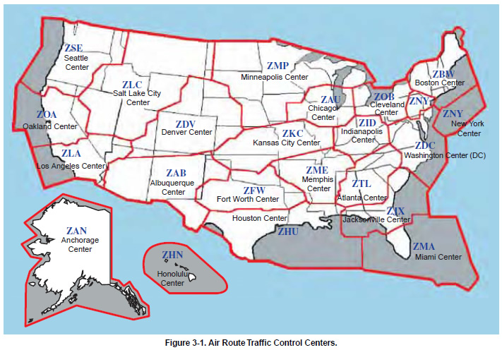
There are 20 ARTCCs in the conterminous United
States (U.S.), and each Center contains between 20 to
80 sectors, with their size, shape, and altitudes determined
by traffic flow, airway structure, and workload.
Appropriate radar and communication sites are connected
to the Centers by microwave links and telephone
lines. [Figure 3-1 on page 3-2]
The CFRs require the pilot in command under IFR in
controlled airspace to continuously monitor an appropriate
Center or control frequency. When climbing after
takeoff, an IFR flight is either in contact with a radarequipped
local departure control or, in some areas, an
ARTCC facility. As a flight transitions to the en route
phase, pilots typically expect a handoff from departure
control to a Center frequency if not already in contact
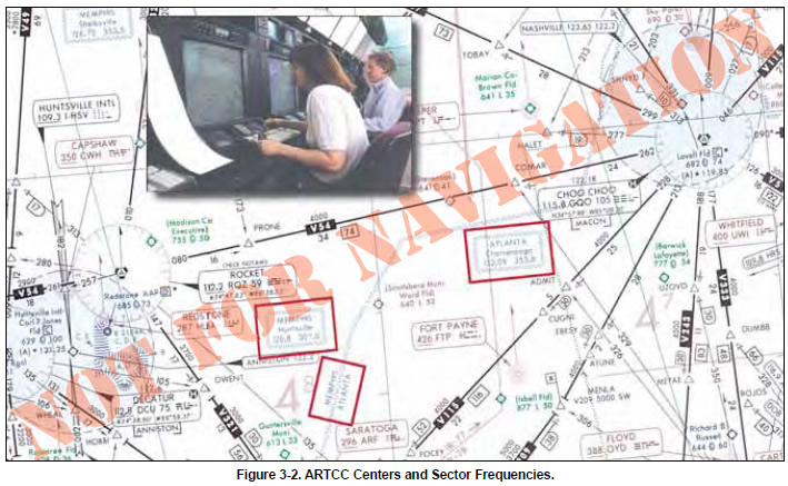
with the Center. The FAA National Aeronautical
Charting Office (NACO) publishes en route charts
depicting Centers and sector frequencies, as shown in
Figure 3-2 on page 3-2. During handoff from one Center
to another, the previous controller assigns a new frequency.
In cases where flights may be still out of range,
the Center frequencies on the face of the chart are very
helpful. In Figure 3-2 on page 3-2, notice the boundary
between Memphis and Atlanta Centers, and the
remoted sites with discrete very high frequency (VHF)
and ultra high frequency (UHF) for communicating
with the appropriate ARTCC. These Center frequency
boxes can be used for finding the nearest frequency
within the aircraft range. They also can be used
for making initial contact with the Center for clearances.
The exact location for the Center transmitter is not
shown, although the frequency box is placed as close as
possible to the known location.
During the en route phase, as a flight transitions from
one Center facility to the next, a handoff or transfer of
control is required as previously described. The handoff
procedure is similar to the handoff between other radar facilities, such as departure or approach control.
During the handoff, the controller whose airspace is
being vacated issues instructions that include the name
of the facility to contact, appropriate frequency, and
other pertinent remarks.
Accepting radar vectors from controllers does not relieve
pilots of their responsibility for safety of flight. Pilots
must maintain a safe altitude and keep track of their position,
and it is their obligation to question controllers,
request an amended clearance, or, in an emergency, deviate
from their instructions if they believe that the safety
of flight is in doubt. Keeping track of altitude and position
when climbing, and during all other phases of flight,
are basic elements of situational awareness. Aircraft
equipped with an enhanced ground proximity warning
system (EGPWS) or terrain awareness and warning system
(TAWS) and traffic alert and collision avoidance
system (TCAS) help pilots detect and correct unsafe altitudes
and traffic conflicts. Regardless of equipment,
pilots must always maintain situational awareness
regarding their location and the location of traffic in their
vicinity. |
