|
|
| INSTRUMENT PROCEDURES HANDBOOK |
|
NAVIGATIONAL GAPS Where a navigational course guidance gap exists,
referred to as an MEA gap, the airway or route segment
may still be approved for navigation. The navigational
gap may not exceed a specific distance that varies
directly with altitude, from zero NM at sea level to 65
NM at 45,000 feet MSL and not more than one gap may
exist in the airspace structure for the airway or route
segment. Additionally, a gap usually does not occur at
any airway or route turning point. To help ensure the
maximum amount of continuous positive course guidance
available when flying, there are established en
route criteria for both straight and turning segments.
Where large gaps exist that require altitude changes,
MEA “steps” may be established at increments of not
less than 2,000 feet below 18,000 feet MSL, or not less
than 4,000 feet at 18,000 MSL and above, provided that
a total gap does not exist for the entire segment within
the airspace structure. MEA steps are limited to one
step between any two facilities to eliminate continuous
or repeated changes of altitude in problem areas. The
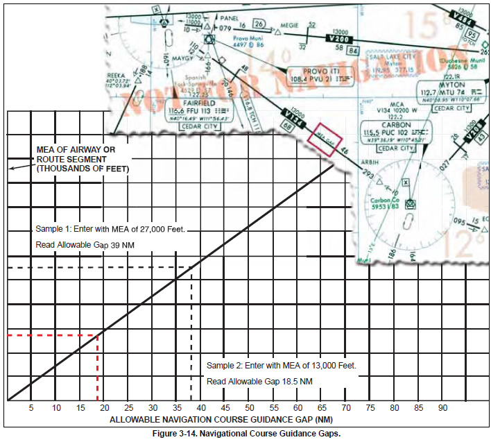
allowable navigational gaps pilots can expect to see are determined, in part, by reference to the graph
depicted in Figure 3-14. Notice the en route chart
excerpt depicting that the MEA is established with a
gap in navigation signal coverage northwest of the
Carbon VOR/DME on V134. At the MEA of 13,000,
the allowable navigation course guidance gap is
approximately 18.5 NM, as depicted by Sample 2. The
navigation gap area is not identified on the chart by
distances from the navigation facilities.
|