|
MINIMUM EN ROUTE ALTITUDE
The minimum enroute altitude (MEA) is the lowest
published altitude between radio fixes that assures
acceptable navigational signal coverage and meets
obstacle clearance requirements between those fixes.
The MEA prescribed for a Federal airway or segment,
RNAV low or high route, or other direct route applies
to the entire width of the airway, segment, or route
between the radio fixes defining the airway, segment,
or route. MEAs for routes wholly contained within
controlled airspace normally provide a buffer above the
floor of controlled airspace consisting of at least 300
feet within transition areas and 500 feet within control
areas. MEAs are established based upon obstacle clearance
over terrain and manmade objects, adequacy of
navigation facility performance, and communications
requirements, although adequate communication at the
MEA is not guaranteed.
MINIMUM OBSTRUCTION CLEARANCE ALTITUDE
The minimum obstruction clearance altitude (MOCA)
is the lowest published altitude in effect between fixes
on VOR airways, off-airway routes, or route segments
that meets obstacle clearance requirements for the entire
route segment. This altitude also assures acceptable navigational
signal coverage only within 22 NM of a VOR.
The MOCA seen on the NACO en route chart, may have
been computed by adding the required obstacle clearance
(ROC) to the controlling obstacle in the primary
area or computed by using a TERPS chart if the controlling
obstacle is located in the secondary area. This figure
is then rounded to the nearest 100 - foot increment, i.e.,
2,049 feet becomes 2,000, and 2,050 feet becomes 2,100
feet. An extra 1,000 feet is added in mountainous areas,
in most cases. The MOCA is based upon obstacle clearance
over the terrain or over manmade objects, adequacy
of navigation facility performance, and communications
requirements.
ATC controllers have an important role in helping pilots
remain clear of obstructions. Controllers are instructed
to issue a safety alert if the aircraft is in a position that, in
their judgment, places the pilot in unsafe proximity to
terrain, obstructions, or other aircraft. Once pilots inform
ATC of action being taken to resolve the situation, the
controller may discontinue the issuance of further alerts.
A typical terrain/obstruction alert may sound like this:
“Low altitude alert. Check your altitude immediately.
The MOCA in your area is 12,000.”
MINIMUM VECTORING ALTITUDES
Minimum vectoring altitudes (MVAs) are established
for use by ATC when radar ATC is exercised. The MVA
provides 1,000 feet of clearance above the highest
obstacle in nonmountainous areas and 2,000 feet above
the highest obstacle in designated mountainous areas.
Because of the ability to isolate specific obstacles, some
MVAs may be lower than MEAs, MOCAs, or other
minimum altitudes depicted on charts for a given
location. While being radar vectored, IFR altitude
assignments by ATC are normally at or above the
MVA.
Controllers use MVAs only when they are assured an
adequate radar return is being received from the aircraft.
Charts depicting minimum vectoring altitudes
are normally available to controllers but not available
to pilots. Situational awareness is always important,
especially when being radar vectored during a climb
into an area with progressively higher MVA sectors,
similar to the concept of minimum crossing altitude.
Except where diverse vector areas have been established,
when climbing, pilots should not be vectored
into a sector with a higher MVA unless at or above the
next sector’s MVA. Where lower MVAs are required
in designated mountainous areas to achieve compatibility
with terminal routes or to permit vectoring to an
instrument approach procedure, 1,000 feet of obstacle
clearance may be authorized with the use of Airport
Surveillance Radar (ASR). The MVA will provide at
least 300 feet above the floor of controlled airspace.
The MVA charts are developed to the maximum radar
range. Sectors provide separation from terrain and
obstructions. Each MVA chart has sectors large
enough to accommodate vectoring of aircraft within
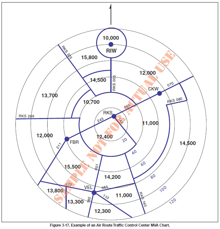
the sector at the MVA. [Figure 3-17]

MINIMUM RECEPTION ALTITUDE
Minimum reception altitudes (MRAs) are determined
by FAA flight inspection traversing an entire
route of flight to establish the minimum altitude the
navigation signal can be received for the route and
for off-course NAVAID facilities that determine a fix.
When the MRA at the fix is higher than the MEA, an
MRA is established for the fix, and is the lowest altitude
at which an intersection can be determined.
MINIMUM CROSSING ALTITUDE
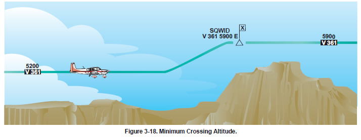
A minimum crossing altitude (MCA) is the lowest altitude
at certain fixes at which the aircraft must cross when
proceeding in the direction of a higher minimum en route
IFR altitude, as depicted in Figure 3-18 on page 3-14.
MCAs are established in all cases where obstacles intervene
to prevent pilots from maintaining obstacle clearance
during a normal climb to a higher MEA after passing a
point beyond which the higher MEA applies. The same
protected en route area vertical obstacle clearance requirements
for the primary and secondary areas are considered
in the determination of the MCA. The standard for determining
the MCA is based upon the following climb
gradients, and is computed from the flight altitude:

- Sea level through 5,000 feet MSL—150 feet per
NM
- 5000 feet through 10,000 feet MSL — 120 feet
per NM
- 10,000 feet MSL and over — 100 feet per NM

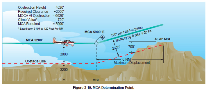
To determine the MCA seen on a NACO en route
chart, the distance from the obstacle to the fix is computed
from the point where the centerline of the en
route course in the direction of flight intersects the
farthest displacement from the fix, as shown in Figure
3-19. When a change of altitude is involved with a
course change, course guidance must be provided if
the change of altitude is more than 1,500 feet and/or if
the course change is more than 45 degrees, although
there is an exception to this rule. In some cases, course
changes of up to 90 degrees may be approved without
course guidance provided that no obstacles penetrate
the established MEA requirement of the previous airway
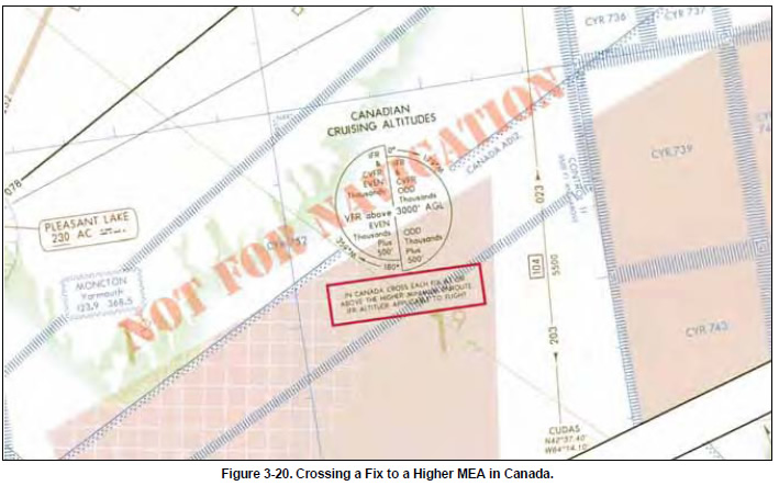
or route segment. Outside U. S. airspace, pilots
may encounter different flight procedures regarding
MCA and transitioning from one MEA to a higher
MEA. In this case, pilots are expected to be at the higher
MEA crossing the fix, similar to an MCA. Pilots must
thoroughly review flight procedure differences when flying
outside U.S. airspace. On NACO en route charts,
routes and associated data outside the conterminous U.S.
are shown for transitional purposes only and are not part
of the high altitude jet route and RNAV route systems.
[Figure 3-20]

|
