|
PREFERRED IFR ROUTES
A system of preferred IFR routes helps pilots, flight
crews, and dispatchers plan a route of flight to minimize
route changes, and to aid in the efficient, orderly
management of air traffic using Federal airways.
Preferred IFR routes are designed to serve the needs of
airspace users and to provide for a systematic flow of
air traffic in the major terminal and en route flight environments.
Cooperation by all pilots in filing preferred
routes results in fewer air traffic delays and better efficiency
for departure, en route, and arrival air traffic
service. [Figure 3-3]
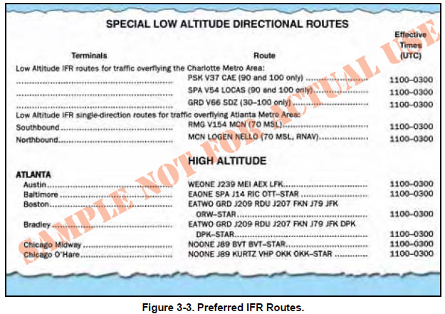
Preferred IFR routes are published in the
Airport/Facility Directory for the low and high altitude
stratum. If they begin or end with an airway number, it
indicates that the airway essentially overlies the airport
and flights normally are cleared directly on the airway.
Preferred IFR routes beginning or ending with a fix
indicate that pilots may be routed to or from these fixes
via a standard instrument departure (SID) route, radar
vectors, or a standard terminal arrival route (STAR).
Routes for major terminals are listed alphabetically
under the name of the departure airport. Where several
airports are in proximity they are listed under the principal
airport and categorized as a metropolitan area;
e.g., New York Metro Area. One way preferred IFR
routes are listed numerically showing the segment fixes
and the direction and times effective. Where more than
one route is listed, the routes have equal priority for
use. Official location identifiers are used in the route
description for very high frequency omnidirectional
ranges (VORs) and very high frequency omnidirectional
ranges/tactical air navigation (VORTACs), and
intersection names are spelled out. The route is direct
where two NAVAIDs, an intersection and a NAVAID, a
NAVAID and a NAVAID radial and distance point, or
any navigable combination of these route descriptions
follow in succession.
SUBSTITUTE EN ROUTE FLIGHT PROCEDURES
Air route traffic control centers are responsible for specifying
essential substitute airway and route segments and
fixes for use during VOR/VORTAC shutdowns.
Scheduled shutdowns of navigational facilities require
planning and coordination to ensure an uninterrupted
flow of air traffic. A schedule of proposed facility shutdowns
within the region is maintained and forwarded as
far in advance as possible to enable the substitute routes
to be published. Substitute routes are normally based on
VOR/VORTAC facilities established
and published for use in
the appropriate altitude strata. In
the case of substitute routes in
the upper airspace stratum, it may
be necessary to establish routes
by reference to VOR/VORTAC
facilities used in the low altitude
system. Nondirectional radio beacon
(NDB) facilities may only be
used where VOR/VORTAC coverage
is inadequate and ATC
requirements necessitate use
of such NAVAIDs. Where
operational necessity dictates,
navigational aids may be used
beyond their standard service
volume (SSV) limits, provided
that the routes can be
given adequate frequency pro-
Figure 3-3. Preferred IFR Routes. tection.
The centerline of substitute routes must be contained
within controlled airspace, although substitute routes
for off-airway routes may not be in controlled airspace.
Substitute routes are flight inspected to verify
clearance of controlling obstacles and to check for
satisfactory facility performance. To provide pilots
with necessary lead time, the substitute routes are submitted
in advance of the en route chart effective date. If
the lead time cannot be provided, the shutdown may be
delayed or a special graphic NOTAM may be considered.
Normally, shutdown of facilities scheduled for 28
days (half the life of the en route chart) or less will not
be charted. The format for describing substitute routes
is from navigational fix to navigational fix. A minimum
en route altitude (MEA) and a maximum authorized
altitude (MAA) is provided for each route segment.
Temporary reporting points may be substituted for the
out-of-service facility and only those other reporting
points that are essential for air traffic control. Normally,
temporary reporting points over intersections are not
necessary where Center radar coverage exists. A minimum
reception altitude (MRA) is established for each
temporary reporting point.
|
