|
WAYPOINTS
Waypoints are specified geographical locations, or
fixes, used to define an RNAV route or the flight path
of an aircraft employing RNAV. Waypoints may be any
of the following types: predefined, published waypoints,
floating waypoints, or user-defined waypoints.
Predefined, published waypoints are defined relative to
VOR-DME or VORTAC stations or, as with GPS, in
terms of latitude/longitude coordinates.
USER-DEFINED WAYPOINTS
Pilots typically create user-defined waypoints for use
in their own random RNAV direct navigation. They are
newly established, unpublished airspace fixes that are
designated geographic locations/positions that help
provide positive course guidance for navigation and a
means of checking progress on a flight. They may or
may not be actually plotted by the pilot on en route
charts, but would normally be communicated to ATC in
terms of bearing and distance or latitude/longitude. An
example of user-defined waypoints typically includes
those derived from database RNAV systems whereby
latitude/longitude coordinate-based waypoints are generated
by various means including keyboard input, and
even electronic map mode functions used to establish
waypoints with a cursor on the display. Another example
is an offset phantom waypoint, which is a point-in-space
formed by a bearing and distance from NAVAIDs, such as
VORTACs and tactical air navigation (TACAN) stations,
using a variety of navigation systems. When specifying
unpublished waypoints in a flight plan, they can be communicated
using the frequency/bearing/distance format or
latitude and longitude, and they automatically become
compulsory reporting points unless otherwise advised by
ATC. All airplanes with latitude and longitude navigation
systems flying above FL 390 must use latitude and
longitude to define turning points.
FLOATING WAYPOINTS
Floating waypoints, or reporting points, represent airspace
fixes at a point in space not directly associated
with a conventional airway. In many cases, they may be
established for such purposes as ATC metering fixes,
holding points, RNAV-direct routing, gateway waypoints,
STAR origination points leaving the en route
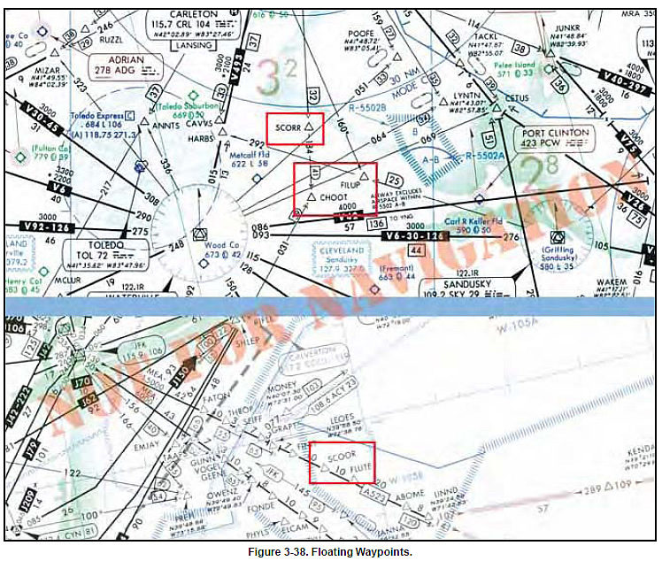
structure, and SID terminating points joining the enroute structure. In Figure 3-38, in the top example, a
NACO low altitude en route chart depicts three floating
waypoints that have been highlighted, SCORR, FILUP,
and CHOOT. Notice that waypoints are named with
five-letter identifiers that are unique and pronouncable.
Pilots must be careful of similar waypoint names.
Notice on the high altitude en route chart excerpt in the
bottom example, the similar sounding and spelled
floating waypoint named SCOOR, rather than
SCORR. This emphasizes the importance of correctly
entering waypoints into database-driven
navigation systems. One waypoint character
incorrectly entered into your navigation system
could adversely affect your flight. The SCOOR
floating reporting point also is depicted on a
Severe Weather Avoidance Plan (SWAP) en route
chart. These waypoints and SWAP routes assist
pilots and controllers when severe weather affects
the East Coast.
|
