|
VHF AIRWAYS/ROUTES
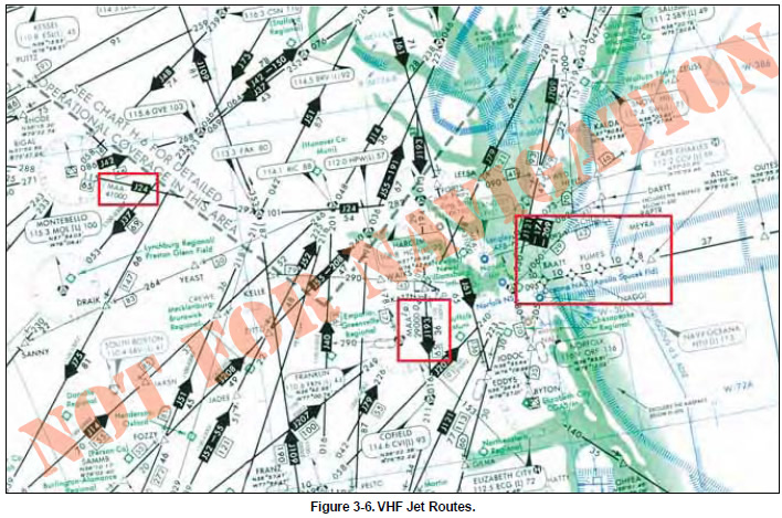
Figure 3-6 depicts numerous arrowed, single direction
jet routes on this excerpt from a NACO en route high
altitude chart, effective at and above 18,000 feet MSL
up to and including FL 450. Notice the MAAs of 41,000
and 29,000 associated with J24 and J193, respectively.
Additionally, note the BAATT, NAGGI, FUMES, and
MEYRA area navigation (RNAV) waypoints.
Waypoints are discussed in detail later in this chapter.
VHF EN ROUTE OBSTACLE CLEARANCE AREAS
All published routes in the NAS are based on specific
obstacle clearance criteria. An understanding of en
route obstacle clearance areas helps with situational
awareness and may help avoid controlled flight into terrain
(CFIT). Obstacle clearance areas for the en route
phase of flight are identified as primary, secondary, and
turning areas.
The primary and secondary area obstacle clearance criteria,
airway and route widths, and the ATC separation
procedures for en route segments are a function of
safety and practicality in flight procedures. These flight
procedures are dependent upon the pilot, the aircraft,
and the navigation system being used, resulting in a
total VOR system accuracy factor, along with an associated
probability factor. The pilot/aircraft information
component of these criteria includes pilot ability to
track the radial and the flight track resulting from turns
at various speeds and altitudes under different wind
conditions. The navigation system information
includes navigation facility radial alignment displacement,
transmitter monitor tolerance, and receiver
accuracy. All of these factors were considered during
development of en route criteria. From this analysis,
the computations resulted in a total system accuracy
of ±4.5° 95 percent of the time and ±6.7° 99 percent
of the time. The 4.5° figure became the basis for primary
area obstacle clearance criteria, airway and
route widths, and the ATC separation procedures. The
6.7° value provides secondary obstacle clearance area
dimensions. Figure 3-7 depicts the primary and secondary
obstacle clearance areas.
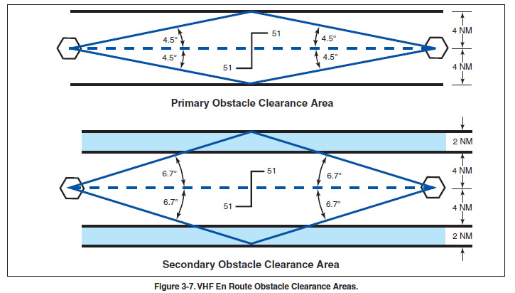
PRIMARY AREA
The primary obstacle clearance area has a protected
width of 8 nautical miles (NM) with 4 NM on each
side of the centerline. The primary area has widths of
route protection based upon system accuracy of a
±4.5° angle from the NAVAID. These 4.5° lines
extend out from the NAVAID and intersect the boundaries
of the primary area at a point approximately 51
NM from the NAVAID. Ideally, the 51 NM point is
where pilots would change over from navigating away
from the facility, to navigating toward the next facility,
although this ideal is rarely achieved.
 If the distance from the NAVAID to the changeover
point (COP) is more than 51 NM, the outer boundary
of the primary area extends beyond the 4 NM width
along the 4.5° line when the COP is at midpoint. This
means the primary area, along with its obstacle clearance
criteria, is extended out into what would have
been the secondary area. Additional differences in the
obstacle clearance area result in the case of the effect of
an offset COP or dogleg segment. For protected en
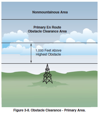
route areas the minimum obstacle clearance in the primary
area, not designated as mountainous under Part
95 — IFR altitude is 1,000 feet over the highest obstacle.
[Figure 3-8] If the distance from the NAVAID to the changeover
point (COP) is more than 51 NM, the outer boundary
of the primary area extends beyond the 4 NM width
along the 4.5° line when the COP is at midpoint. This
means the primary area, along with its obstacle clearance
criteria, is extended out into what would have
been the secondary area. Additional differences in the
obstacle clearance area result in the case of the effect of
an offset COP or dogleg segment. For protected en
route areas the minimum obstacle clearance in the primary
area, not designated as mountainous under Part
95 — IFR altitude is 1,000 feet over the highest obstacle.
[Figure 3-8]
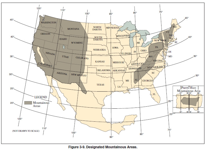
Mountainous areas for the Eastern and Western U.S.
are designated in Part 95, as shown in Figure 3-9 on
page 3-8. Additional mountainous areas are designated
for Alaska, Hawaii, and Puerto Rico. With some
exceptions, the protected en route area minimum
obstacle clearance over terrain and manmade obstacles
in mountainous areas is 2,000 feet. Obstacle
clearance is sometimes reduced to not less than 1,500
feet above terrain in the designated mountainous areas
of the Eastern U.S., Puerto Rico, and Hawaii, and may
be reduced to not less than 1,700 feet in mountainous
areas of the Western U.S. and Alaska. Consideration is
given to the following points before any altitudes providing
less than 2,000 feet of terrain clearance are
authorized:
- Areas characterized by precipitous terrain.
- Weather phenomena peculiar to the area.
- Phenomena conducive to marked pressure differentials.
- Type of and distance between navigational facilities.
- Availability of weather services throughout the
area.
- Availability and reliability of altimeter resetting
points along airways and routes in the area.
Altitudes providing at least 1,000 feet of obstacle clearance
over towers and/or other manmade obstacles may
be authorized within designated mountainous areas if
the obstacles are not located on precipitous terrain where
Bernoulli Effect is known or suspected to exist.
Bernoulli Effect, atmospheric eddies, vortices, waves,
and other phenomena that occur in conjunction with disturbed
airflow associated with the passage of strong
winds over mountains can result in pressure deficiencies
manifested as very steep horizontal pressure gradients.
Since downdrafts and turbulence are prevalent under
these conditions, potential hazards may be multiplied.
|
