|
|
| INSTRUMENT PROCEDURES HANDBOOK |
|
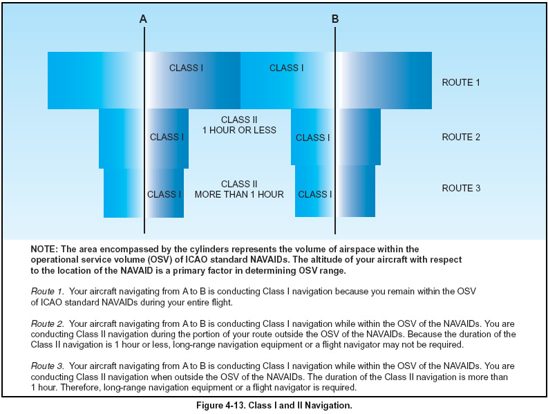
ARRIVAL NAVIGATION CONCEPTS Today, the most significant and demanding navigational requirement is the need to safely separate aircraft. In a nonradar environment, ATC does not have an independent means to separate air traffic and must depend entirely on information relayed from flight crews to determine the actual geographic position and altitude. In this situation, precise navigation is critical to ATC’s ability to provide separation. Even in a radar environment, precise navigation and position reports, when required, are still the primary means of providing separation. In most situations,ATC does not have the capability or the responsibility for navigating an aircraft. Because they rely on precise navigation by the flight crew, flight safety in all IFR operations depends directly on your ability to achieve and maintain certain levels of navigational performance. ATC uses radar to monitor navigational performance, detect possible navigational errors, and expedite traffic flow. In a nonradar environment, ATC has no independent knowledge of the actual position of your aircraft or its relationship to other aircraft in adjacent airspace. Therefore, ATC’s ability to detect a navigational error and resolve collision hazards is seriously degraded when a deviation from a clearance occurs. The concept of navigation performance, previously discussed in this book, involves the precision that must be maintained for both the assigned route and altitude. Required levels of navigation performance vary from area to area depending on traffic density and complexity of the routes flown. The level of navigation performance must be more precise in domestic airspace than in oceanic and remote land areas since air traffic density in domestic airspace is much greater. For example, there are two million flight operations conducted within Chicago Center’s airspace each year. The minimum lateral distance permitted between co-altitude aircraft in Chicago Center’s airspace is 8 NM (3 NM when radar is used). The route ATC assigns an aircraft has protected airspace on both sides of the centerline, equal to one-half of the lateral separation minimum standard. For example, the overall level of lateral navigation performance necessary for flight safety must be better than 4 NM in Center airspace. When STARs are reviewed subsequently in this chapter, you will see how the navigational requirements become more restrictive in the arrival phase of flight where air traffic density increases and procedural design and obstacle clearance become more limiting. The concept of navigational performance is fundamental to the code of federal regulations, and is best defined in Parts 121.103 and 121.121, which state that each aircraft must be navigated to the degree of accuracy required for air traffic control. The requirements of Part 91.123 related to compliance with ATC clearances and instructions also reflect this fundamental concept. Commercial operators must comply with their Operations Specifications (OpsSpecs) and understand the categories of navigational operations and be able to navigate to the degree of accuracy required for the control of air traffic. In the broad concept of air navigation, there are two major categories of navigational operations consisting of Class I navigation and Class II navigation. Class I navigation is any en route flight operation conducted in controlled or uncontrolled airspace that is entirely within operational service volumes of ICAO standard NAVAIDs (VOR, VOR/DME, NDB). Class II navigation is any en route operation that is not categorized as Class I navigation and includes any operation or portion of an operation that takes place outside the operational service volumes of ICAO standard NAVAIDs. For example, your aircraft equipped only with VORs conducts Class II navigation when your flight operates in an area outside the operational service volumes of federal VORs. Class II navigation does not automatically require the use of long-range, specialized navigational systems if special navigational techniques are used to supplement conventional NAVAIDs. Class II navigation includes transoceanic operations and operations in desolate and remote land areas such as the Arctic. The primary types of specialized navigational systems approved for Class II operations include inertial navigation system (INS), Doppler, and global positioning system (GPS). Figure 4-13 provides several examples of Class I and II navigation.
A typical limitations entry in a commercial operator’s pilot handbook states, “The area navigation system used for IFR Class I navigation meets the performance/accuracy criteria of AC 20-130A for en route and terminal area navigation.” The subject of AC 20-130A is Airworthiness Approval of Navigation or Flight Management Systems Integrating Multiple Navigation Sensors.
|