|
|
| INSTRUMENT PROCEDURES HANDBOOK |
|
DESCENT PLANNING Prior to flight, calculate the fuel, time, and distance required to descend from your cruising altitude to the approach gate altitude for the specific instrument approach of your destination airport. In order to plan your descent, you need to know your cruise altitude, approach gate altitude or initial approach fix altitude, descent groundspeed, and descent rate. Update this information while in flight for changes in altitude, weather, and wind. Your flight manual or operating handbook may also contain a fuel, time, and distance to descend chart that contains the same information. The calculations should be made before the flight and “rules of thumb” updates should be applied in flight. For example, from the charted STAR you might plan a descent based on an expected clearance to “cross 40 DME West of Brown VOR at 6,000” and then apply rules of thumb for slowing down from 250 knots. These might include planning your airspeed at 25 NM from the runway threshold to be 250 knots, 200 knots at 20 NM, and 150 knots at 15 NM until gear and flap speeds are reached, never to fall below approach speed.
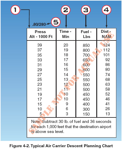
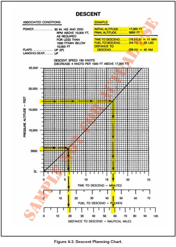
The need to plan the IFR descent into the approach gate and airport environment during the preflight planning stage of flight is particularly important for turbojet powered airplanes. A general rule of thumb for initial IFR descent planning in jets is the 3 to 1 formula. This means that it takes 3 NM to descend 1,000 feet. If an airplane is at flight level (FL) 310 and the approach gate or initial approach fix is at 6,000 feet, the initial descent requirement equals 25,000 feet (31,000 - 6,000). Multiplying 25 times 3 equals 75; therefore begin descent 75 NM from the approach gate, based on a normal jet airplane, idle thrust, speed Mach 0.74 to 0.78, and vertical speed of 1,800 - 2,200 feet per minute. For a tailwind adjustment, add 2 NM for each 10 knots of tailwind. For a headwind adjustment, subtract 2 NM for each 10 knots of headwind. During the descent planning stage, try to determine which runway is in use at the destination airport, either by reading the latest aviation routine weather report (METAR) or checking the automatic terminal information service (ATIS) information. There can be big differences in distances depending on the active runway and STAR. The objective is to determine the most economical point for descent. An example of a typical jet descent-planning chart is depicted in Figure 4-2. Item 1 is the pressure altitude from which the descent begins; item 2 is the time required for the descent in minutes; item 3 is the amount of fuel consumed in pounds during descent to sea level; and item 4 is the distance covered in NM. Item 5 shows that the chart is based on a Mach .80 airspeed until 280 knots indicated airspeed (KIAS) is obtained. The 250- knot airspeed limitation below 10,000 feet mean sea level (MSL) is not included on the chart, since its effect is minimal. Also, the effect of temperature or weight variation is negligible and is therefore omitted. Due to the increased cockpit workload, you want to get as much done ahead of time as possible. As with the climb and cruise phases of flight, you should consult the proper performance charts to compute your fuel requirements as well as the time and distance needed for your descent. Figure 4-3 is an example of a descent-planning chart. If you are descending from 17,000 feet to a final (approach gate) altitude of 5,650, your time to descend is 11 minutes and distance to descend is 40 NM.
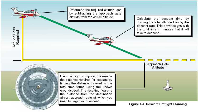
During the cruise and descent phases of flight, you need to monitor and manage the airplane according to the appropriate manufacturer’s recommendations. The flight manuals and operating handbooks contain cruise and descent checklists, performance charts for specific cruise configurations, and descent charts that provide information regarding the fuel, time, and distance required to descend. Review this information prior to the departure of every flight so you have an understanding of how your airplane is supposed to perform at cruise and during descent. A stabilized descent constitutes a pre-planned maneuver in which the power is properly set, and minimum control input is required to maintain the appropriate descent path. Excessive corrections or control inputs indicate the descent was improperly planned. Plan your IFR descent from cruising altitude so you arrive at the approach gate altitude or initial approach fix altitude prior to beginning the instrument approach. [Figure 4-4 on page 4-4]
Descending from cruise altitude and entering the approach environment can be a busy time during the flight. You are talking on the radio, changing radio frequencies, pulling out different charts, adjusting controls, reading checklists, all of which can be distracting. By planning your descent in advance, you reduce the workload required during this phase of flight, which is smart workload management. Pilots often stay as high as they can as long as they can, so planning the descent prior to arriving at the approach gate is necessary to achieve a stabilized descent, and increases situational awareness. Using the information given, calculate the distance needed to descend to the approach gate.
Subtract 2,100 feet from 17,000 feet, which equals 14,900 feet. Divide this number by 1,500 feet per minute, which equals 9.9 minutes, round this off to 10 minutes. Using your flight computer, find the distance required for the descent by using the time of 10 minutes and the groundspeed of 155 knots. This gives you a distance of 25.8 NM. You need to begin your descent approximately 26 NM prior to arriving at your destination airport approach gate.
|